HOME
FORECAST
Local
Graphical
Aviation
Marine
Rivers and Lakes
Hurricanes
Severe Weather
Fire Weather
Sunrise/Sunset
Long Range Forecasts
Climate Prediction
Space Weather
PAST WEATHER
Past Weather
Astronomical Data
Certified Weather Data
SAFETY
INFORMATION
Wireless Emergency Alerts
Weather-Ready Nation
Brochures
Cooperative Observers
Daily Briefing
Damage/Fatality/Injury Statistics
Forecast Models
GIS Data Portal
NOAA Weather Radio
Publications
SKYWARN Storm Spotters
StormReady
TsunamiReady
Service Change Notices
EDUCATION
NEWS
SEARCH
Search For
NWS
All NOAA
ABOUT
About NWS
Organization
For NWS Employees
National Centers
Careers
Contact Us
Glossary
Social Media
NWS Transformation
Local forecast by
"City, St" or ZIP code
Sorry, the location you searched for was not found. Please try another search.
Multiple locations were found. Please select one of the following:
Location Help
News Headlines
Important Beach and Rip Current Forecasts - Know Before You Go
Updated Drought Information Statement
Customize Your
Weather.gov
Enter Your City, ST or ZIP Code
Remember Me
LOADING...
Wakefield, VA
Weather Forecast Office
Fire Weather Briefing Page
Weather.gov
>
Wakefield, VA
> Fire Weather Briefing Page
Current Hazards
River Flooding
Briefing Page
Winter
Local Outlook
Space
Drought
Thunderstorms
Hurricanes
Current Conditions
Satellite
Rainfall
Air Quality
Observations (Map)
Observations (List)
Marine Obs (Map)
Marine Obs (List)
Regional Radar&Satellite
Rainfall Monitor Page
Radar
Local Enhanced Radar
Local KAKQ Standard Radar (low bandwidth)
Regional Standard Radar (low bandwidth)
National Standard Radar (low bandwidth)
Dover Radar(low bandwidth)
Forecasts
Aviation
Map View
Forecasters' Discussion
Hourly View
Tropical
Marine
Beach & Surf
Fire Weather
Forecast Models
Agriculture Weather Page
Routine Text Product
Enhanced Forecast Graphics
Tide Forecast & Reference
Coastal Flood
Rivers and Lakes
Current & Past Streamflow
Ensemble River Guidance
River Observations (Map)
River Forecast Centers
River Forecasts (Map)
River Summary Page
James River Richmond White Water
Climate and Past Weather
Past Rainfall
CoCoRaHS
24 Hour Summary
Snowfall Records
Past Observed Weather
Drought Outlook
Climate Prediction
NWS Wakefield Main Climate Page
Tropical Cyclone Reports
Local Programs
Met Calculator
Office Newsletter
Office Tours
Past Office News Archive & Event Review
SKYWARN
Sun/Moon Data
Astronomical
NOAA WEATHER RADIO
Virtual Presentations
Main Briefing
Page
Severe
Thunderstorms
Tides/Coastal
Flooding
Rivers/River
Flooding
Extended Forecasts
& Drought
Space Weather
Fire Weather
Rain and Snow
Forecasts
Hurricanes
Marine Weather
Radar and
Satellite
Climate Data
Maps and
Models
Safety and
Preparedness
Wakefield Radar
Dover AFB Radar
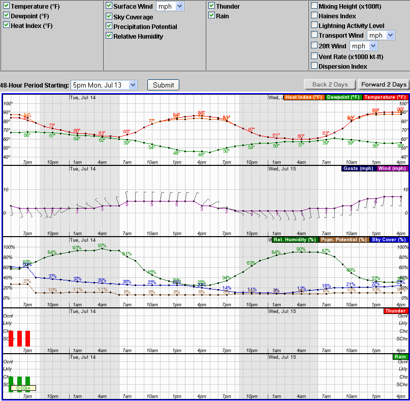
Forecast Graph
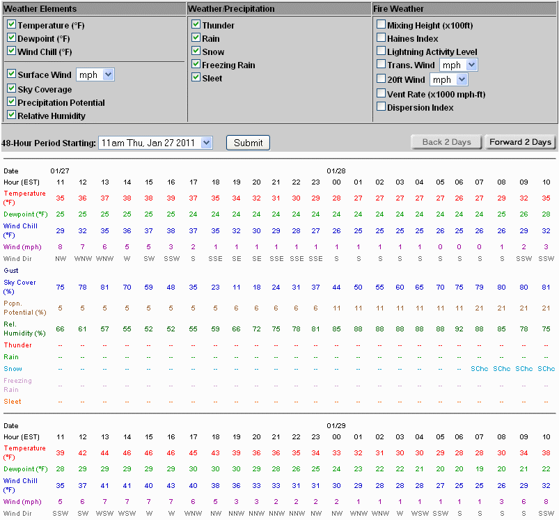
Forecast Table
Forecast Images
Fire Weather Forecast
Point Fire Weather
Forecast (RAWS Sites)
Fire Weather Warnings
Fire Danger Statements
National Wildfire
Assessment Page
Request a Spot Forecast
Area Forecast
Discussion (AFD)
NWS National
Fire Weather Page
Wakefield Fire
Weather Page
Fire Weather Outlooks and Parameters
Mouseover/tap to Change Graphic
SPC National Outlooks
Day 1 Outlook
Day 2 Outlook
Days 3-8 Outlook
Fuel Moisture (FM) Graphics
10 Hour FM (Observed)
10 Hour FM (Forecast)
100 Hour FM (Observed)
100 Hour FM (Forecast)
1000 Hour FM (Observed)
1000 Hour FM (Forecast)
Drought Status Graphics
Keetch-Byrum Index
Palmer Drought Index
Observed Soundings
Wallops Island
Dulles
Greensboro
Blacksburg
Morehead City
Radar
Current Weather
Rivers & Lakes
Satellite
Forecast Maps
Hour by Hour Forecast
Tropical Weather
Graphical Hazards
Briefings
Marine Forecasts
Forecaster's Discussion
SKYWARN
Submit Storm Report
Climate Data
Fire Weather
Beach & Surf
Coastal Flood
Heat
Follow us on X
Follow us on Facebook
AKQ RSS Feed


 Coastal Flood
 Heat
Heat