Overview
A deep upper level trough swept across the southern US and turned northeastward offshore of the east coast from the morning of January 3 through the morning of January 4, 2018. The interaction between the cold upper trough and the relatively warmer Atlantic waters resulted in tremendous intensification of a surface low pressure system that tracked from around Miami, FL to just offshore of Cape Cod on January 3 and 4. A good deal of moisture wrapped into this system and was lifted across much of the east coast, resulting in a broad area of moderate to heavy snowfall. A heavy band of snow impacted portions of the Taconics, Berkshires, Litchfield Hills, and southern Green Mountains from the late morning through the afternoon hours of January 4, resulting in snowfall rates up to 3" per hour and total snowfall amounts mainly in the 7 to 15 inch range. To the west of the heavy snowband across the Hudson, Mohawk, and Schoharie Valleys, a widespread 3 to 7 inches of snowfall occurred. Gusty northerly winds occurred with this system as well, with gusts of 30-45 mph recorded. The winds and falling snow contributed to reduced visibility and blowing and drifting of snow. The snowfall tapered off in the evening of January 4.Snow/Wind Reports

Public Information Statement
Spotter Reports
National Weather Service Albany NY
1055 AM EST Fri Jan 05 2018

The following are unofficial observations taken during the past 30
hours for the storm that has been affecting our region. Appreciation
is extended to highway departments, cooperative observers, Skywarn
spotters and media for these reports. This summary also is available
on our home page at weather.gov/albany

********************STORM TOTAL SNOWFALL********************

LOCATION          STORM TOTAL     TIME/DATE   COMMENTS
                     SNOWFALL           OF
                     /INCHES/   MEASUREMENT

CONNECTICUT

...Litchfield County...
   Winsted               15.0   900 PM  1/04  Public
   1 N Thomaston         14.0   700 AM  1/05  CoCoRaHS
   5 NNW Winsted         13.8   700 AM  1/05  CoCoRaHS
   Bakersville           13.3   600 PM  1/04  Co-Op Observer
   3 SW New Hartford     13.3   700 AM  1/05  CoCoRaHS
   Harwinton             13.0   630 PM  1/04  Public
   Torrington            12.0   330 PM  1/04  Social Media
   5 W Woodbury Center   11.0   215 PM  1/04  Trained Spotter
   Norfolk               11.0   800 AM  1/05  Co-Op Observer
   4 SSW Cornwall Bridg  10.8   700 AM  1/05  CoCoRaHS
   Warren                10.5   545 AM  1/05  Twitter
   New Hartford          10.5   404 PM  1/04  Social Media
   1 WNW Oakville        10.0   720 AM  1/05  CoCoRaHS
   Canaan                 7.0   414 PM  1/04  WeatherNet6

MASSACHUSETTS

...Berkshire County...
   1 N Otis Wood Lanes   14.0   738 AM  1/05  Ski Area
   5 NW Otis             12.2   700 AM  1/05  CoCoRaHS
   Sandisfield           12.0   600 PM  1/04  WTEN
   Otis                  12.0   600 PM  1/04  WTEN
   Savoy                 10.2  1019 PM  1/04  WeatherNet6
   2 E Hancock           10.0   727 AM  1/05  Ski Area
   Lenoxdale             10.0   600 PM  1/04  Co-Op Observer
   Tyringham             10.0   600 PM  1/04  WTEN
   Clarksburg             9.2   508 AM  1/05  WeatherNet6
   Becket                 9.0   349 PM  1/04  WeatherNet6
   Stockbridge            9.0   600 PM  1/04  WTEN
   North Adams            8.0   600 PM  1/04  WTEN
   Great Barrington       8.0   415 PM  1/04  Trained Spotter
   2 SE Belcher Square    7.0   744 AM  1/05  Ski Area
   3 NE Housatonic        6.0   600 AM  1/05  CoCoRaHS

NEW YORK

...Albany County...
   3 N Selkirk            5.5   700 AM  1/05  CoCoRaHS
   1 W Albany             5.0   700 AM  1/05  CoCoRaHS
   1 NE Shakers           4.9   745 AM  1/05  ASOS
   Boght Corners          4.5   930 PM  1/04  NWS Employee
   Latham                 4.2   420 PM  1/04  WeatherNet6
   Cohoes                 4.0   500 PM  1/04  WeatherNet6
   2 W Albany             4.0   630 PM  1/04  Retired NWS Emp.
   2 WNW Guilderland      4.0   700 AM  1/05  CoCoRaHS
   Colonie                3.7   609 PM  1/04  WeatherNet6
   Albany                 3.6   700 PM  1/04  NWSFO Albany
   2 S Colonie            3.6   700 AM  1/05  CoCoRaHS
   1 SSW Menands          3.1   415 PM  1/04  WNYT Studios
   Knox                   3.0   722 PM  1/04  WeatherNet6
   Preston Hollow         2.5   430 PM  1/04  Social Media

...Columbia County...
   Kinderhook             7.0   600 PM  1/04  WTEN
   Copake                 7.0   521 AM  1/05  WeatherNet6
   North Chatham          6.8   413 PM  1/04  WeatherNet6
   Taghkanic              6.2   636 AM  1/05  WeatherNet6
   Austerlitz             6.0   923 PM  1/04  WeatherNet6
   Ancramdale             5.6   456 AM  1/05  WeatherNet6
   Germantown             4.0   421 PM  1/04  WeatherNet6
   Livingston             3.0   958 PM  1/04  WeatherNet6

...Dutchess County...
   Poughquag             10.5   405 PM  1/04  1050 feet
   6 ESE Pleasant Valle   8.3   700 AM  1/05  CoCoRaHS
   6 NNW Poughquag        8.3   700 PM  1/04  Public
   2 SSE Hopewell Junct   6.7   700 AM  1/05  CoCoRaHS
   Hopewell Junction      6.5   530 PM  1/04  CoCoRaHS
   Red Hook               5.8   411 PM  1/04  WeatherNet6
   2 SW Elizaville        5.0   330 PM  1/04  Trained Spotter
   Rhinebeck              4.4   245 PM  1/04  Public
   Poughkeepsie           4.0   700 AM  1/05  Co-Op Observer
   Fairview               4.0   500 PM  1/04  Trained Spotter
   1 NE Red Hook          3.3   700 AM  1/05  CoCoRaHS
   2 SSE Poughkeepsie     2.8  1019 PM  1/04  Trained Spotter
   1 WSW Red Oaks Mill    2.8   500 AM  1/05  CoCoRaHS

...Fulton County...
   Broadalbin             4.0   600 PM  1/04  WTEN
   7 NW GLOVERSVILLE      2.8   800 AM  1/05  Co-Op Observer
   Fishhouse              2.0   405 PM  1/04  WeatherNet6
   Northville             2.0   344 PM  1/04  WeatherNet6
   Perth                  2.0  1006 PM  1/04  WeatherNet6

...Greene County...
   Cairo                  5.0   419 PM  1/04  WeatherNet6
   Halcott Center         5.0   413 AM  1/05  WeatherNet6
   East Jewett            4.7   700 AM  1/05  Co-Op Observer
   7 SSE Westerlo         4.5   500 AM  1/05  CoCoRaHS
   Greenville Center      4.5   539 PM  1/04  WeatherNet6
   Catskill               4.0   414 PM  1/04  WeatherNet6
   Kiskatom               4.0   457 AM  1/05  WeatherNet6

...Hamilton County...
   2 SW Indian Lake       1.0   815 AM  1/05  Co-Op Observer
   Wells                  1.0   423 PM  1/04  WeatherNet6
   Long Lake              0.5   600 PM  1/04  WTEN

...Herkimer County...
   Ilion                  0.9   700 AM  1/05  CoCoRaHS

...Montgomery County...
   Amsterdam              3.5   419 PM  1/04  WeatherNet6
   5 NW Charleston Four   3.5   345 PM  1/04  Social Media
   Fonda                  3.1   403 PM  1/04  WeatherNet6
   Fultonville            3.0   600 PM  1/04  WTEN
   Glen                   2.5   844 PM  1/04  WeatherNet6
   Palatine Bridge        2.0   349 PM  1/04  WeatherNet6
   Fort Plain             1.0   700 AM  1/05  CoCoRaHS

...Rensselaer County...
   6 E Poestenkill       13.0   733 AM  1/05  Ski Area
   Averill Park           8.4   800 AM  1/05  CoCoRaHS
   1 WNW Averill Park     8.4  1044 PM  1/04  Meteorologist
   5 E Waterford          7.5   700 AM  1/05  CoCoRaHS
   Center Brunswick       7.3   957 PM  1/04  WeatherNet6
   Poestenkill            7.0   830 PM  1/04  Social Media
   East Schodack          6.5   600 PM  1/04  Trained Spotter
   East Greenbush         6.0   725 PM  1/04  Trained Spotter
   1 N Sycaway            5.5  1000 PM  1/04  NWS Employee
   2 NE Troy              5.5   700 AM  1/05  CoCoRaHS
   West Sand Lake         5.0   900 PM  1/04  Trained Spotter
   Speigletown            3.5   351 PM  1/04  WeatherNet6
   2 WSW Eagle Bridge     3.0   400 PM  1/04  Co-Op Observer

...Saratoga County...
   Lake Desolation        4.2   452 AM  1/05  WeatherNet6
   Malta                  4.0   915 PM  1/04  WeatherNet6
   2 SE Clifton Park      4.0   600 AM  1/05  CoCoRaHS
   Ballston Lake          4.0   550 PM  1/04  Social Media
   2 S Clifton Park Cen   3.6  1047 PM  1/04  Retired NWS Emp.
   Ballston Spa           3.2   359 PM  1/04  WeatherNet6
   2 ESE Ballston Spa     3.0   810 AM  1/05  CoCoRaHS
   3 S Saratoga Lake      3.0   700 AM  1/05  CoCoRaHS
   Saratoga Springs       2.8   600 AM  1/05  CoCoRaHS
   Charlton               2.5   421 PM  1/04  WeatherNet6
   1 SSE Porter Corners   1.5   815 AM  1/05  CoCoRaHS
   Edinburg               1.5   426 PM  1/04  WeatherNet6
   1 W Gansevoort         1.4   600 AM  1/05  CoCoRaHS

...Schenectady County...
   Delanson               4.0   728 AM  1/05  WeatherNet6
   Schenectady            3.6   939 PM  1/04  WeatherNet6
   Schenectady-GE Plot    3.3   715 PM  1/04  NWS Employee
   Glenville              3.0   413 PM  1/04  WeatherNet6
   Duanesburg             3.0   418 PM  1/04  WeatherNet6
   Niskayuna              3.0   700 AM  1/05  Co-Op Observer
   1 SSW Aqueduct         2.8   730 PM  1/04  NWS Employee
   1 NNE Hawthorne Hill   2.7   900 PM  1/04  NWS Employee

...Schoharie County...
   Gilboa                 5.0   343 PM  1/04  WeatherNet6
   Jefferson              4.0   719 AM  1/05  WeatherNet6
   Charlotteville         3.8   440 PM  1/04  WeatherNet6
   Richmondville          3.8   404 PM  1/04  WeatherNet6
   Esperance              3.5   630 PM  1/04  Social Media
   Schoharie              3.5   735 AM  1/05  Co-Op Observer
   Seward                 2.0   322 PM  1/04  WeatherNet6
   7 N North Blenheim     2.0   800 AM  1/05  Co-Op Observer
   2 ESE Cobleskill       1.8   735 AM  1/05  Co-Op Observer

...Ulster County...
   Wallkill               6.1   430 PM  1/04  Trained Spotter
   Esopus                 5.5   338 PM  1/04  WeatherNet6
   1 WNW Rosendale Vill   4.5   700 AM  1/05  CoCoRaHS
   Phoenicia              4.5   456 AM  1/05  WeatherNet6
   Kingston               3.2   300 PM  1/04  Public
   3 ENE Kerhonkson       3.0   225 PM  1/04  Social Media
   West Shokan            2.0   422 AM  1/05  WeatherNet6
   Highmount              2.0   634 AM  1/05  WeatherNet6
   West Hurley            1.0   730 AM  1/05  CoCoRaHS

...Warren County...
   Warrensburg            2.5   515 AM  1/05  WeatherNet6
   Lake Luzerne           2.0   600 AM  1/05  Co-Op Observer
   5 SE North Creek       2.0   700 AM  1/05  Co-Op Observer
   Queensbury             1.8   443 AM  1/05  WeatherNet6
   2 WNW Warrensburg      1.7   800 AM  1/05  CoCoRaHS

...Washington County...
   5 SW NORTH HEBRON      5.0   700 AM  1/05  Co-Op Observer
   Hebron                 5.0   523 AM  1/05  WeatherNet6
   Cambridge              3.0   600 PM  1/04  Social Media
   Fort Edward            2.0   600 PM  1/04  WTEN
   Whitehall              2.0   800 AM  1/05  Co-Op Observer
   Hudson Falls           1.2   515 AM  1/05  WeatherNet6

VERMONT

...Bennington County...
   Woodford              14.0   617 AM  1/05  WeatherNet6
   1 NNE Bromley Villag   9.0   645 AM  1/05  Ski Area
   Pownal                 8.5   519 PM  1/04  WeatherNet6
   West Arlington         8.5   443 AM  1/05  WeatherNet6
   1 E Manchester Cente   8.3   700 AM  1/05  CoCoRaHS
   Landgrove              8.2   640 AM  1/05  WeatherNet6

...Windham County...
   Brattleboro            9.0   530 PM  1/04  Social Media
   3 E Somerset           9.0   634 AM  1/05  Ski Area
   3 SSW Putney           7.1   700 PM  1/04  Trained Spotter
   Vernon                 7.0   747 PM  1/04  Social Media
   2 SSW Stratton Mount   7.0   726 AM  1/05  Ski Area
   Wilmington             6.0   354 PM  1/04  WeatherNet6
   Marlboro               5.9   900 AM  1/05  Co-Op Observer
   3 WSW Charlestown      5.3   700 AM  1/05  CoCoRaHS
Public Information Statement
National Weather Service Albany NY
826 PM EST Thu Jan 4 2018

...Wind Reports...

Location                     Speed     Time/Date       Elevation (ft.)

...Connecticut...

...Litchfield County...
3 SW Torrington              42 MPH    0455 PM 01/04   1220
1 SSW Oakville               37 MPH    0653 PM 01/04   730
2 ESE Torrington             37 MPH    0718 PM 01/04   967
2 WSW New Hartford           36 MPH    0814 PM 01/04   1043
2 NW Terryville              33 MPH    0658 PM 01/04   865
Litchfield                   26 MPH    0305 PM 01/04   981
1 WNW Woodbury Center        23 MPH    0725 PM 01/04   472
3 ENE Torrington             21 MPH    0651 PM 01/04   912
Norfolk                      21 MPH    0730 PM 01/04   956
2 ENE New Hartford           20 MPH    0805 PM 01/04   862

...Massachusetts...

...Berkshire County...
2 SE Adams                   51 MPH    0710 PM 01/04   1555
2 NNW Sheffield              42 MPH    0725 PM 01/04   662
2 WSW East Windsor           40 MPH    0545 PM 01/04   1894
Harriman-and-west Airport    37 MPH    0554 PM 01/04   653
3 SW Williamstown            29 MPH    0516 PM 01/04   997
Great Barrington             25 MPH    0540 PM 01/04   708
3 NNE Pittsfield             25 MPH    0628 PM 01/04   1123
3 SW Williamstown            22 MPH    0749 PM 01/04   918
1 NE Great Barrington        21 MPH    0747 PM 01/04   698

...New York...

...Albany County...
2 W Voorheesville            37 MPH    0635 PM 01/04   377
2 NE Preston Hollow          36 MPH    0725 PM 01/04   1247
1 W Knox                     34 MPH    0724 PM 01/04   1292
2 SW Voorheesville           33 MPH    0537 PM 01/04   456
Albany Intl Ap               32 MPH    0734 PM 01/04   275
2 SSE Delmar                 32 MPH    0641 PM 01/04   160

...Columbia County...
1 NW Kinderhook              36 MPH    0725 PM 01/04   238
2 NE Copake                  31 MPH    0705 PM 01/04   685
2 E Claverack                25 MPH    0806 PM 01/04   541
3 ESE Catskill               25 MPH    0735 PM 01/04   185
Chatham                      25 MPH    0729 PM 01/04   436
1 N Niverville               22 MPH    0750 PM 01/04   332

...Dutchess County...
Hudson Valley Regional Airpo 41 MPH    0228 PM 01/04   164
Red Hook                     38 MPH    0745 PM 01/04   212
6 ESE Pleasant Valley        38 MPH    0341 PM 01/04   643
1 ENE Cornwall On Hudson     34 MPH    0618 PM 01/04   63
2 NE Beacon                  31 MPH    0410 PM 01/04   295
1 NE Hopewell Junction       29 MPH    0749 PM 01/04   1483
1 NNW Wappingers Falls       29 MPH    0639 PM 01/04   308
Fairview                     24 MPH    0504 PM 01/04   236

...Fulton County...
4 N Saint Johnsville         31 MPH    0710 PM 01/04   1181
2 ESE Johnstown              25 MPH    0804 PM 01/04   880
2 SSE Broadalbin             25 MPH    0750 PM 01/04   3051

...Greene County...
1 SE Hunter                  30 MPH    0753 PM 01/04   1606
4 NE Fleischmanns            25 MPH    0445 PM 01/04   2254

...Hamilton County...
1 ESE Eagle Bay              18 MPH    0431 PM 01/04   1715
2 SE Indian Lake             17 MPH    0809 PM 01/04   1637

...Herkimer County...
1 WNW Herkimer               29 MPH    0500 PM 01/04   713
3 ENE Cold Brook             28 MPH    0505 PM 01/04   1421
3 S Dolgeville               25 MPH    0501 PM 01/04   1525
Dolgeville                   22 MPH    0658 PM 01/04   845

...Montgomery County...
4 ENE East Springfield       37 MPH    0650 PM 01/04   1043
3 ESE Canajoharie            31 MPH    0740 PM 01/04   655
2 N Tribes Hill              25 MPH    0805 PM 01/04   745

...Rensselaer County...
2 WSW Hancock                31 MPH    0300 PM 01/04   950
3 ESE Castleton-on-Hudso     28 MPH    0735 PM 01/04   344
5 ESE Waterford              27 MPH    0600 PM 01/04   912
Averill Park                 26 MPH    0741 PM 01/04   633
3 WSW Hoosick Falls          25 MPH    0250 PM 01/04   856
2 ENE Wyantskill             20 MPH    0722 PM 01/04   505

...Saratoga County...
1 W Edinburg                 27 MPH    0730 PM 01/04   1065
4 ESE Niskayuna              21 MPH    0739 PM 01/04   214

...Schenectady County...
2 SW Mariaville              38 MPH    0715 PM 01/04   1368
East Glenville               30 MPH    0719 PM 01/04   377
1 N Schenectady              28 MPH    0811 PM 01/04   344

...Schoharie County...
1 W Cobleskill               28 MPH    0340 PM 01/04   1076

...Ulster County...
4 E Phoenicia                47 MPH    0751 PM 01/04   1072
1 NNE Wallkill               33 MPH    0715 PM 01/04   353
3 WSW Tillson                27 MPH    0625 PM 01/04   633
1 SSW New Paltz              27 MPH    0338 PM 01/04   339
3 WSW Hyde Park              25 MPH    0644 PM 01/04   344
3 N Kerhonkson               21 MPH    0654 PM 01/04   898

...Warren County...
Floyd Bennett Memorial Airpo 31 MPH    0707 PM 01/04   321
9 NW Bolton Landing          23 MPH    0705 PM 01/04   1089

...Washington County...
Granville                    24 MPH    0700 PM 01/04   419
5 S Whitehall                23 MPH    0335 PM 01/04   119

...Vermont...

...Bennington County...
4 ESE Woodford State Park    41 MPH    0631 PM 01/04   2802
3 WSW Peru                   39 MPH    0450 PM 01/04   1928
Bennington State Airport     32 MPH    0404 PM 01/04   826
3 WSW Woodford State Park    27 MPH    0611 PM 01/04   2395
1 NNE Old Bennington         26 MPH    0610 PM 01/04   657

...Windham County...
2 NW Vernon                  42 MPH    0621 PM 01/04   632
Brattleboro                  39 MPH    0730 PM 01/04   374
5 NNW Wilmington             39 MPH    0810 PM 01/04   2099
1 E Townshend                36 MPH    0647 PM 01/04   1677
2 SSW Putney                 28 MPH    0659 PM 01/04   354
Wilmington                   28 MPH    0634 PM 01/04   1492
4 N Townshend                23 MPH    0702 PM 01/04   1799

Observations are collected from a variety of sources with varying
equipment and exposures. We thank all volunteer weather observers
for their dedication. Not all data listed are considered official.
Radar: (click to enlarge)
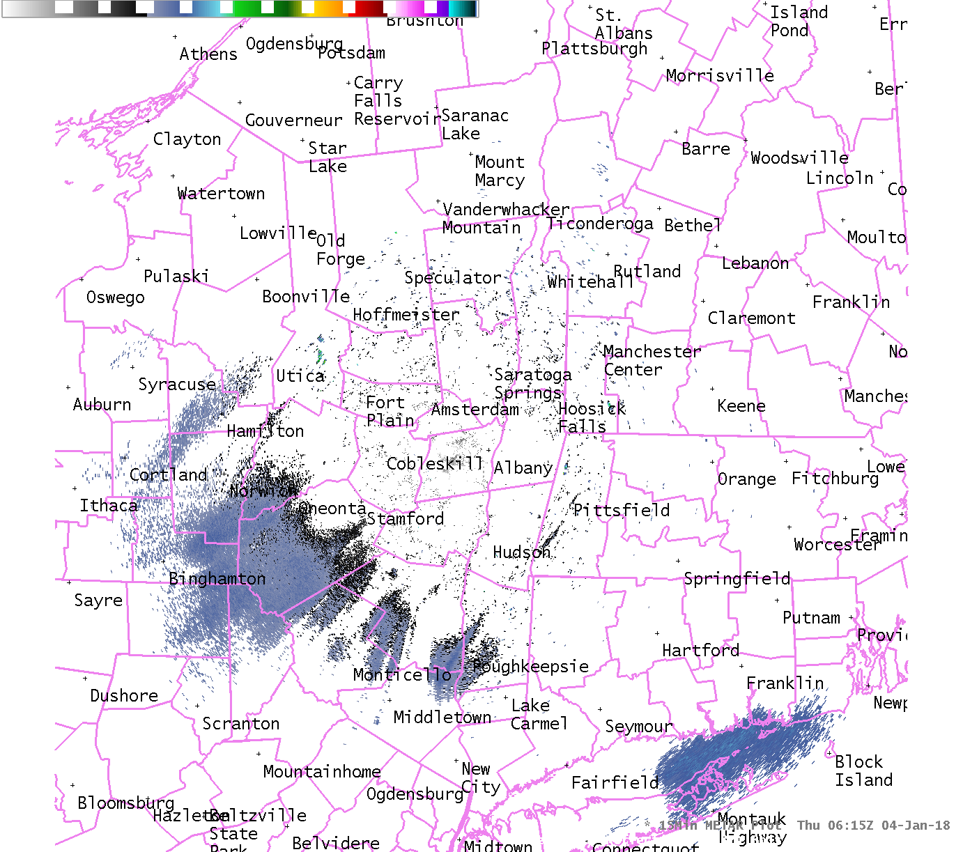 |
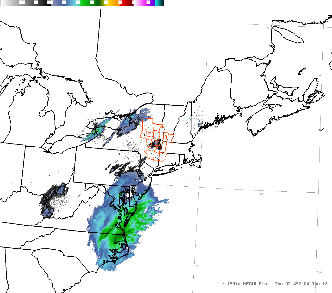 |
| KENX (East Berne, NY) radar 1:15 am to 9:00 pm January 4, 2018 | Regional radar loop 9:45 pm January 3 to 7:00 pm January 4, 2018 |
Satellite: (click to enlarge)
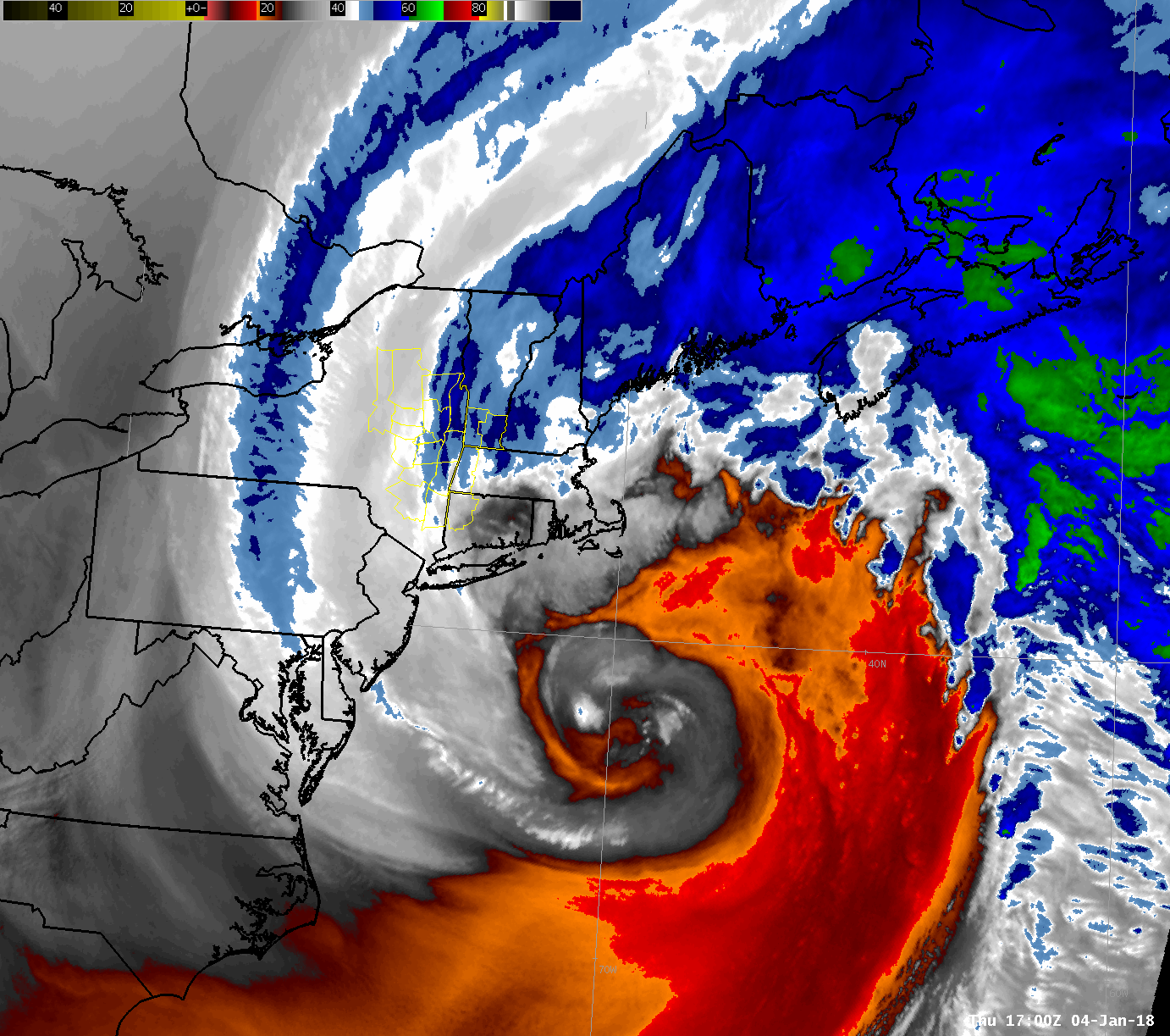 |
 |
| GOES-16 mid-level water vapor loop 12:00 pm January 4 to 1:00 am January 5, 2018 | GOES-16 1-minute visible satellite imagery from mesoscale sector 12:20 pm to 1:30 pm January 4, 2018 |
Additional GOES-16 loops courtesy NOAA/NESDIS and C. Velden, Univ. of Wisconsin-SSEC:
Environment
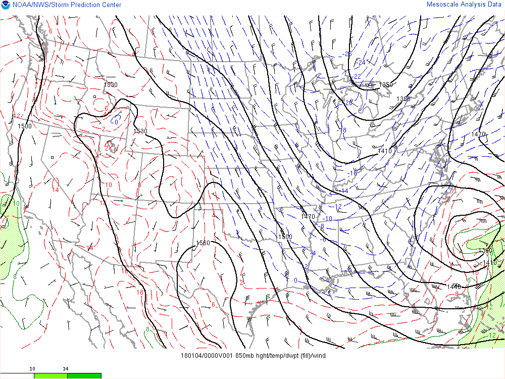
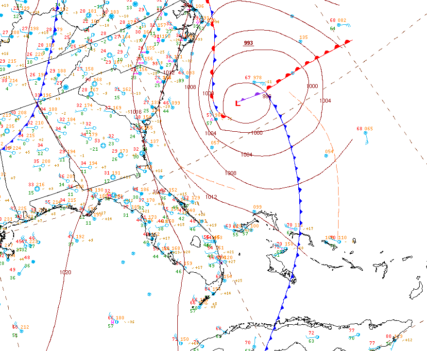
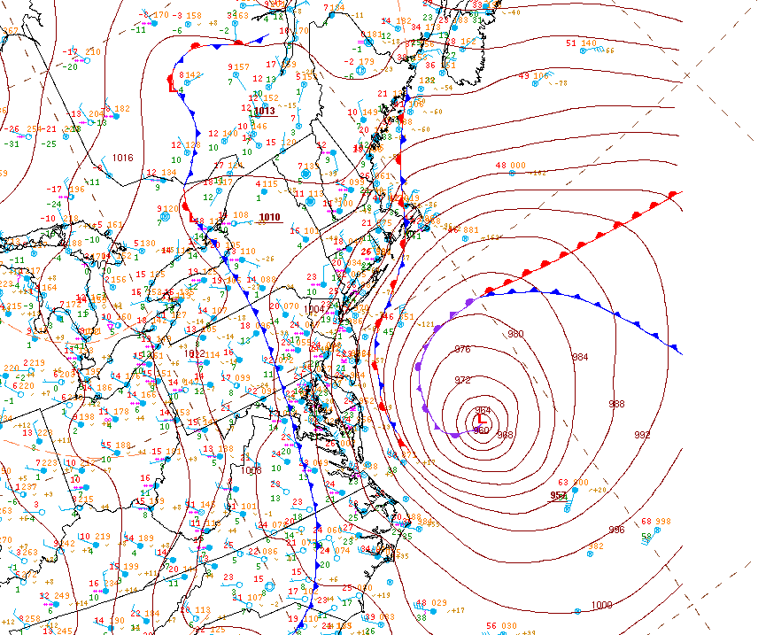
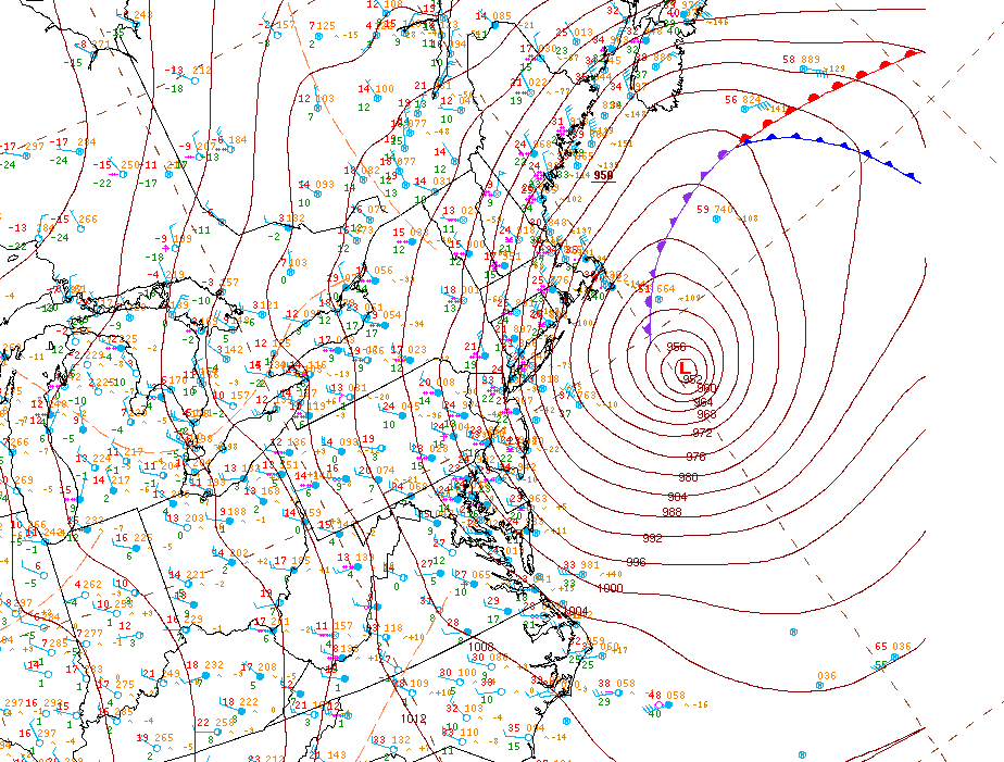
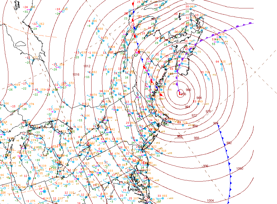
The incredibly strong and rapidly strengthening 4 January 2018 cyclone was associated with a deep 500 mb trough that tracked through the southeastern US (Fig. 1) and became sharply negatively tilted as it ejected up the east coast. Unseasonably cold air was associated with this trough (Fig. 2), resulting in accumulating snowfall as far south as northern Florida and coastal portions of Georgia and the Carolinas. The surface low fed off the baroclinic instability associated with the sharp temperature gradient between the cold upper trough and warmer air over the Atlantic. A truly remarkable rate of deepening of 59 mb in 24 hours occurred with this cyclone as it went from 1010 mb at 15Z 3 Jan to 950 mb at 15Z 4 Jan (Figs 3-7)! To put this in perspective, this is over twice the deepening rate of a meteorological "bomb", defined as a cyclone that deepens 24 mb in 24 hours.
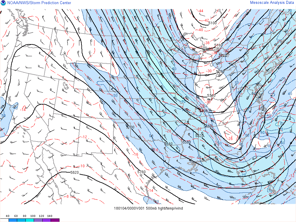 |
 |
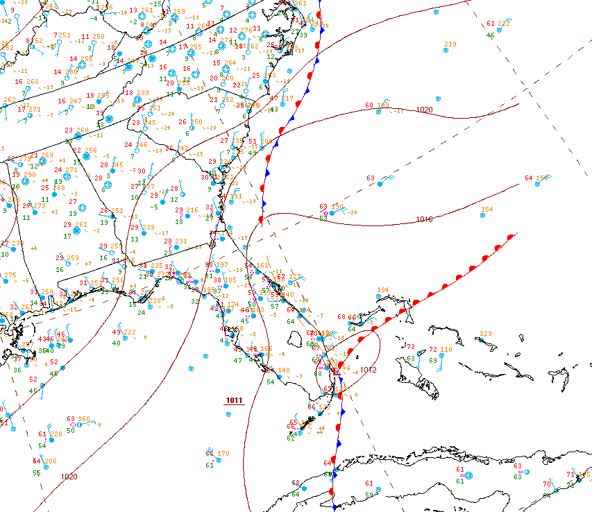 |
| Figure 1: RAP 1-h forecast of 500 mb height (thick contours, m), temp (thin contours, C), and wind (barbs, kt) valid 0000 UTC 4 Jan. From SPC Mesoanalysis archive. | Figure 2: RAP 1-h forecast of 850 mb height (thick contours, m), temp (thin contours, C), dewpoint (fills, C) and wind (barbs, kt) valid 0000 UTC 4 Jan. From SPC Mesoanalysis archive. | Figure 3: WPC analysis valid 12Z 3 Jan. |
 |
 |
 |
| Figure 4: WPC analysis valid 00Z 4 Jan. | Figure 5: WPC analysis valid 12Z 4 Jan. | Figure 6: WPC analysis valid 18Z 4 Jan. |
 |
| Figure 7: WPC analysis valid 00Z 5 Jan. |
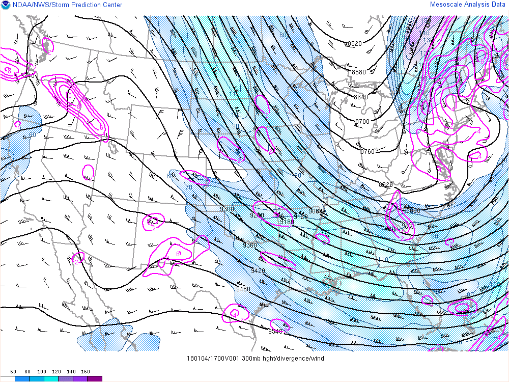
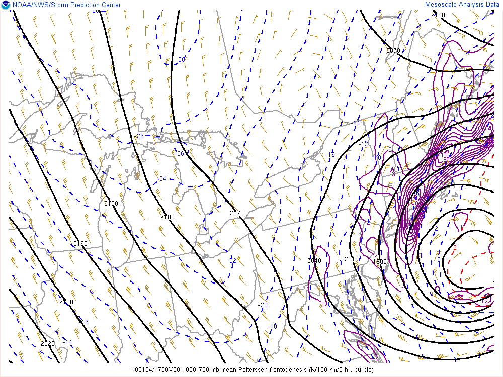
Ascent occurred over the local forecast area beneath the right entrance region of a strong 300 mb jet, resulting in light snowfall spreading across much of the forecast area during the morning hours of the 4th (Fig. 8). As the cyclone continued to approach, an area of strong frontogenesis in the 850-700 mb layer spread into southern New England within the confluence of easterly and northerly flow (Fig. 9). The resulting circulation allowed a band of heavy snowfall to pivot into western New England and far southeastern New York, with snowfall rates as high as 3" per hour observed over Litchfield County, CT. This band resided longest and pivoted over Litchfield County from the late morning into the early afternoon, resulting in the highest snowfall totals in the Albany forecast area of 10-15" over much of the county. The heavier frontogenetic bands did not make it much further west than the Taconics of New York, so the remainder of the forecast area saw mainly light to moderate snow. A period of Hudson-Mohawk convergence occurred in the evening over the Capital District (Fig. 10), resulting in locally enhanced snowfall totals. The strong pressure gradient with the cyclone resulted in gusty winds during and after the snowfall, especially over portions of the Mid-Hudson Valley, Taconics, and western New England where wind gusts exceeded 40 mph at times (Fig. 11)
 |
 |
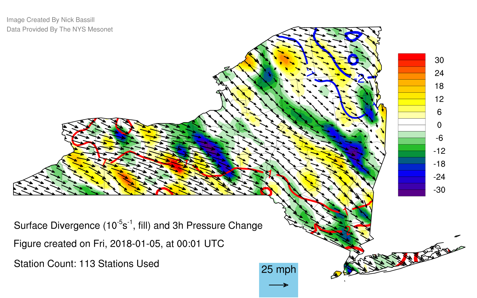 |
| Figure 8: RAP 1-h forecast of 300 mb height (black contours, m), divergence (color contours, s/-1), and wind (barbs, kt) valid 1700 UTC 4 Jan. From SPC Mesoanalysis archive. | Figure 9: RAP 1-h forecast of 850-700 mb mean Petterssen frontogenesis (purple contours, K/100 km/3h), height (black contours, m), and wind (barbs, kt) valid 1700 UTC 4 Jan. From SPC Mesoanalysis archive. | Figure 10: Gridded analysis of surface divergence (fills, 10^-5/s), 3h pressure change (contours), and winds (arrows) at 0000 UTC 5 Jan from New York State Mesonet data. Image courtesy Nick Bassill. |
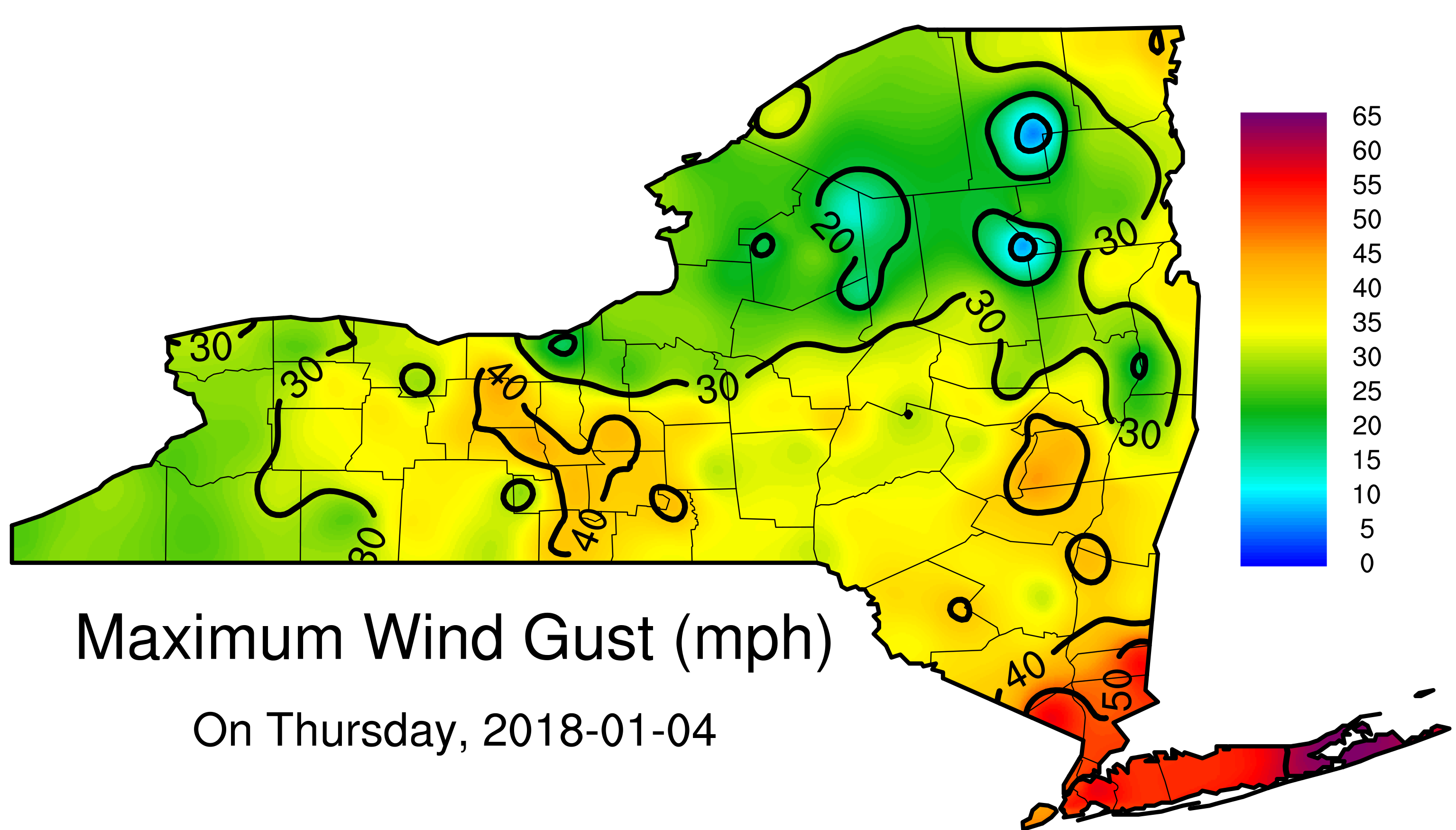 |
| Figure 11: Gridded analysis of peak wind gusts observed on 4 Jan from New York State Mesonet data. Image courtesy Nick Bassill. |
 |
Media use of NWS Web News Stories is encouraged! Please acknowledge the NWS as the source of any news information accessed from this site. |
|

