The National Weather Service (NWS) Forecast Office in State College central Pennsylvania (KCTP) opened in 1993. It was co-located with the Middle Atlantic River Forecast Center (MARFC) in the Rider II building in downtown State College. The MARFC arrived in State College in January 1993 after a long history, dating to the 1930s in Harrisburg.
KCTP was a new office which evolved out of the 1980s NWS modernization and reorganization (MAR) program. The new forecast office structure affected the Philadelphia, Pittsburgh, and Cleveland forecast areas of responsibilities in Pennsylvania and led to the closing of the smaller Weather Service Office’s (WSO) at Erie, Williamsport, Scranton, and Harrisburg. This ended the era of large forecast offices with areas of responsibilities which included smaller satellite offices within their area of responsibility.
The first NWS employees arrived in the Spring of 1993. The first two employees were electronic technicians (Ray Overline and Glenn Odum). The Meteorological staff began to arrive in May and June 1993. The office’s first meteorologist in-charge (MIC), Robert (Bob) Case, arrived in June 1993. Bob was a well known hurricane forecaster and gained fame in the book and movie The Perfect Storm. The first Warning Coordination Meteorologist (WCM) was Thomas (Tom) Dunham. Bob and Tom had been the Deputy Meteorologists in-charge (DMIC) at the Boston and Buffalo WFO’s respectively. Both were Pennsylvania State University Graduates and had served in the United States Navy. The first Scientific Operations Officer (SOO) was Richard Grumm. The Senior Service Hydrologist (SSH) function still remained with the MARFC (Greg Rishel) but the position was destined to be transferred to the WFO as part of the MAR process.
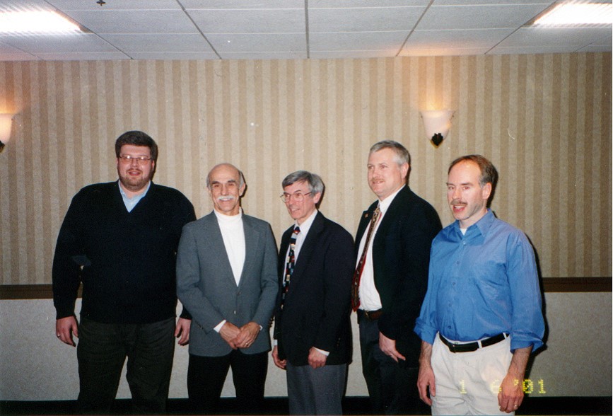 The initial forecast staff in the Spring of 1993 included the MIC, WCM, SOO, and 3 General Meteorologists (Peter Jung, David Martin, and Richard (Rick) Winther (left). The Hydrometeorological (HMT) staff was filled in during the latter half of 1993 as the office spun-up to use the new Doppler radar systems, called NEXRAD at the time and now known as the WSR-88D.
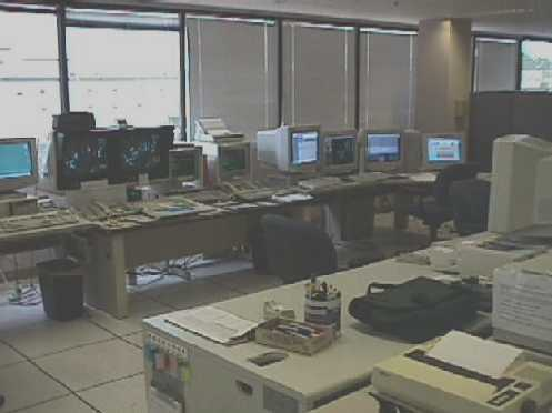 When the staff began arriving in May 1993 (11 May actually) the operations area had several phones on the floor, an odd shaped table known as the “football table” and a single Automation of Field Operations and Services (AFOS) console to monitor the weather. During the summer of 1993 furniture was added and the Principle User Processor (PUP) and Radar Process Generator (RPG) work stations were installed (right). The PUP was the primary means to monitor the radar data to produce short term forecasts and warnings. And odd device, similar to a mouse, called a graphical tablet puck (PUC) was used to navigate a tablet of products and other options.
The radar was located in Black Moshannon State Park near the PSU astronomy telescope. This site was selected as part of the MAR-NEXRAD installation project. The Harrisburg WSO WSR-74C, which was operated from 28 June 1977 to 12 January 1996 was in effect replaced by the KCCX doppler radar. The Erie (KERI) radar was operated from August 1977 through early 2000. The NEXRAD program essentially eliminated or replaced all WSR-74C radars. The site was chosen to avoid beam blockage issues due to terrain, proximity to good communications, and the push for more science within the NWS. The location of the Forecast office and the radar facilitated collaboration with the Pennsylvania State University (PSU) and the Department of Meteorology.
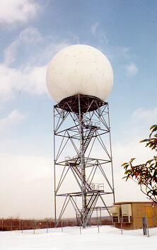 The radar construction was completed July 1993 and data began to flow to the office in July (left). The radar was deemed operational in September 1993 and the office formally began short-term forecast operations using KCCX radar in October 1993. The October 1993 Halloween snow was the first major winter event observed by the radar. Several large severe weather events including several tornadic supercell thunderstorms and a large bow echo were observed in April 1994. The warnings for these storms were produced by the Harrisburg WSO via information relayed to them via phone and AFOS.
Shortly after the radar was commissioned, the PSU TV show Weather World did a feature on the radar. This included a visit to the radar, climbing into the dome and a visit to the office to show the key features the radar could identify (below, right). On a clear cool autumn night, refraction allowed the radar to detect vehicles traveling along I80.
In the Spring of 1994 two new General Forecasters (John LaCorte and David Nicosia) were added to the staff to get to full phase I staffing. The office assumed warning responsibility in 1992 with the first warning issued by Pete Jung on August 2, 1994.
In 1994 the office received an experimental satellite system known as RAMSDIS. This McIDAS based system offered advanced satellite looping and display color display capabilities which did not exist in most NWS forecast offices. RAMSDIS was a significant improvement over the black and white limited control micro-SWIS system.
The final phase of the evolution of the office occurred in 1998 with the installation and commissioning of the original Hewlett Packard based Advanced Weather Interactive Processing System (AWIPS) system. The addition of the 5 Lead forecasters to the Meteorological staff was linked to AWIPS. The 5 Leads were selected by the Spring of 1998 (John LaCorte, David Nicosia, Peter Jung, Barry Lambert, and Michael Evans). Three new  General Forecasters were added to the staff to replace those promoted to Leads.
After full staffing, the office took over full forecast responsibilities in 1998.
In December 2005 the office moved to its new location at Innovation Park (left). The move was facilitated by the Binghamton forecast office, which hosted 5 KCTP staff members from 5 to 9 December 2005 to run KCTP operations remotely from Binghamton.
Over the course of the past 15 years, AWIPS underwent many upgrades and improvements. The National Weather Service got deeper into IDSS and Social media. From a technology perspective, the implementation of GOES-16 into operations was a big project in the 2016-17 timeframe. GOES-16 represented a quantum leap forward in data resolution and quality.
A key focus of the MAR plan was, where possible, to co-locate NWS offices with Universities with a meteorology department. Thus, the NWS office in State College was located close to the PSU Meteorology Department. In the original office location, on Beaver Avenue, the PSU created office and shared workspace. Dr Forbes and his graduate students were located in this space from 1993 to 1998. This facilitated exchanges, joint research projects, access to students, and access to new technologies.
In 1993, the PSU meteorology department provided KCTP with access to the internet. With the purchase of an HP workstation, known as eyewall (eyewall.met.psu.edu), in the autumn of 1993, the NWS in State College gained access to the internet. This facilitated the rapid access to higher-resolution model data sets and the establishment of one of the first NWS websites, known as eyewall.
The internet access facilitated getting raw model files into the office for display in a program known as PCGRIDDS. Prior to internet access, data was acquired via telephone based modems. The internet access improved forecast operations allowing diagnosis of model output. Several surrounding offices requested access to a limited set of this data via modems. Using GEMPAK to process the raw model data, a web based set of forecast graphics was put into production by the Spring of 1994.
The use of the web increased and the webpages were expanded to provide increased amounts of model graphics to the web. By the winter of 1996 the office provided output from the Aviation model (AVN), the Nested Grid Model (NGM), and Stepped terrain model (Eta). Model profiles and meteograms were added via a joint COMET project with the co-located PSU students.
The web presence expanded in 1998 to include a Lagged Average Forecast (LAF) page which showed 3-4 model forecasts valid at the same time. The software was changed from GEMPAK to GrADS in this timeframe. A Medium Range Extended Forecast (MREF) ensemble MOS product was developed in 1998 and a full display of early NCEP based MREF and SREF ensembles was established in October of 1999. All of this work was a cooperative effort between the PSU and the NWS office in State College.
Climate anomalies were part of the initial release of the model and ensemble pages in October 1999. These graphics were hosted on an upgraded version of the eyewall website and backed up on the websites known as nws and meso.
The early use of ensembles and standardized anomalies in the forecast process was the direct result of the co-location of the NWS with the PSU Department of Meteorology.
The web base operational model data was complimented by expanded on-line reviews of extreme and unusual weather events which affected the Mid-Atlantic and portions of the eastern United States.
The internet access provided by the PSU was the primary reason KCTP was chosen as an early RAMSDIS site in 1995. RAMSDIS improved access to satellite data and the use of color enhancements in the pre-AWIPS era.
The close proximity to the PSU Meteorology Department provided students who worked as student trainees in both NWS Offices. Several of these trainees became Interns at these offices and many of these students went on to work at other NWS offices. The program expanded in 2003-2006 to include a course which was taught by a team of NWS personnel.
The students and the co-located PSU office in Rider-II led to local weekly map discussion in the autumn semester of 1994 which continued through 2005. A broader meteorological community based weather discussion was developed by the PSU meteorology Department in 2006 which continues in some form today. This weekly map discussion includes students, PSU faculty, and AccuWeather and NWS personnel.
The establishment of the NWS office in State College in 1993 facilitated change. The early 1990s was a time of change. The internet was just gaining traction, the WSR-88D program was in full installation and implementation mode, AWIPS was right behind it, and the concept of ensemble forecasting was still in the early stages.
The co-location of the NWS with the PSU meteorology department facilitated rapid and relatively efficient change in a decade of new and rapidly-developing technologies.


 Send Us a Report