 |
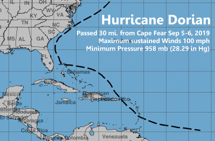
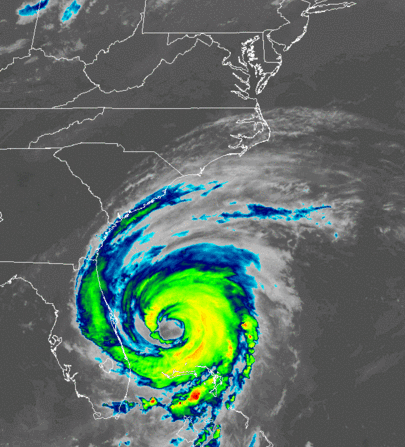
Hurricane Dorian was the strongest and most destructive storm of the 2019 hurricane season. The northern Bahamas, the Abaco Islands, and Grand Bahama Island were devastated by Dorian's category five winds estimated to have reached over 180 mph with a storm surge greater than 18 feet. The storm stalled across Grand Bahama Island on Sunday, September 2 through Monday, September 3. Dorian then slowly weakened to category two strength as persistent rain and wind cooled the ocean beneath the slow-moving storm.
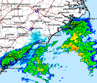
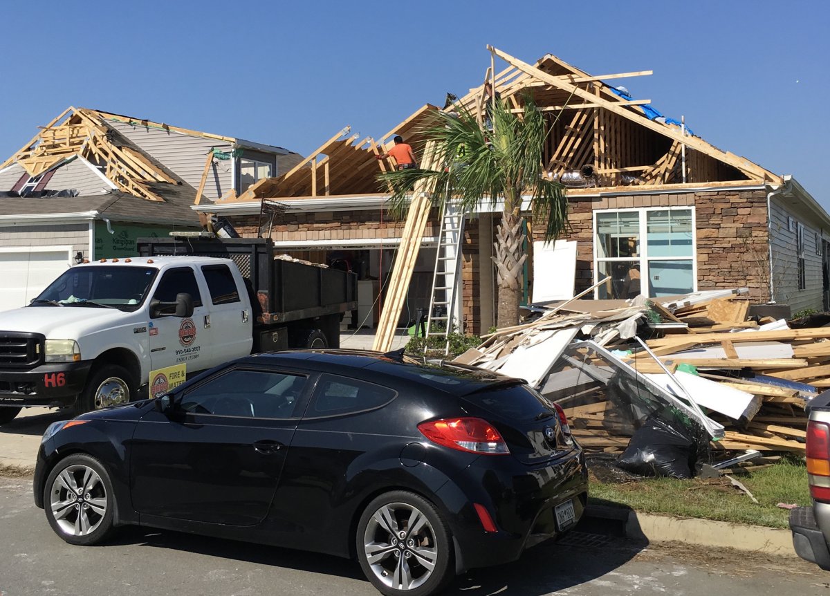
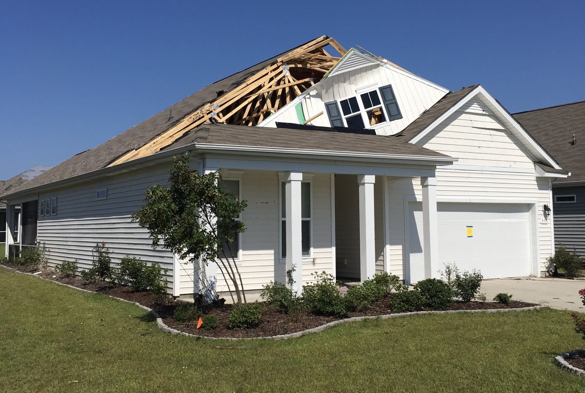
After leaving the Bahamas, Dorian turned northwestward and moved parallel to the Florida east coast on September 4. Bands of showers and thunderstorms ahead of the storm's center produced over a dozen tornadoes across northeastern South Carolina and eastern North Carolina during the morning of Wednesday, September 5. Fortunately for South Carolina and southeastern North Carolina, Dorian continued to turn to the right and the center remained offshore as it approached Cape Fear that evening. Dorian's eye missed Cape Fear by about 30 miles, however the storm made landfall on Ocracoke and Hatteras Islands during the early morning hours of September 6, heavily damaging the southern Outer Banks with wind and a substantial storm surge produced by northwest winds crossing the shallow waters of the Pamlico Sound.
|
Infrared satellite loop of Hurricane Dorian moving north from the Bahamas and affecting eastern South and North Carolina. Higher, colder clouds tops are colored in yellow and red. Loop runs from September 4-6, 2019. |
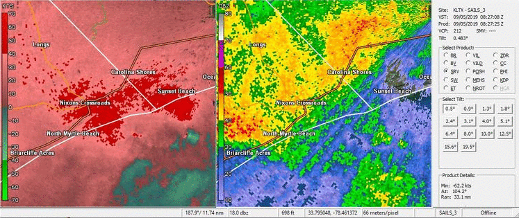
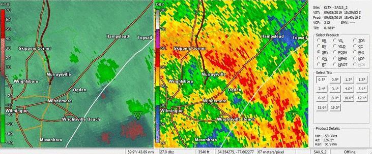
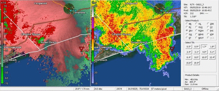
Radar loop from the Wilmington/LTX Doppler radar of Hurricane Dorian moving along the coast of South and North Carolina on September 5-6, 2019. Green-shaded boxes are flash flood warnings; red-shaded boxes are tornado warnings. |
Specific Storm Impacts by County
Georgetown County, SC
Power was knocked out to the entire city of Georgetown. Downed trees and power lines blocked multiple city streets. Water Street in downtown Georgetown flooded due to a combination of heavy rain and storm surge on September 5. Water entered several businesses but damage was generally minor. Sand dunes were breached on Pawley`s Island during high tide, and media reports said water reached knee deep on at least one city street. Newspaper photos showed a number of private docks across the marsh were damaged by surge and waves. All utilities including power and water were lost to Pawley`s Island during the storm. City officials classified beach erosion as "severe," especially along the southern portion of the island where sand covered the entire length of Springs Avenue. The northern portion of Pawley`s Island suffered less beach erosion. No structural damage was noted to any homes. Storm surge pushed water onto streets in Debordieu Plantation south of Pawley`s Island during the afternoon high tide on September 5. Widely shared video on social media showed fast-flowing water moving through neighborhood streets. In Litchfield Beach, water covered many of the town`s roads during high tide, and many wooden walkways across the dunes were destroyed.
Horry County, SC
Storm surge flooding affected Garden City during the afternoon of September 5. Video shared by local media showed six inches of water covering Atlantic Avenue at least two blocks inland from the beach. Flash flooding affected a few Horry County neighborhoods including Grier Crossing and Jordan Estates near the city of Conway. Inlet Square Mall in Garden City had up to two feet of flood water standing in the parking lot. Flash flooding also affected the Surfside Beach Club community. In Cherry Grove, flood water was knee deep on 49th Avenue. North of Conway, Long Avenue Extension was closed as water from Grier Swamp covered hundreds of feet of the highway. Three tornadoes touched down in Horry County during Hurricane Dorian's passage: an EF1 tornado struck Little River at 4:37 a.m., an EF0 tornado developed near Socastee at 5:45 a.m., and another EF0 tornado touched down in North Myrtle Beach at 6:37 a.m.
Brunswick County, NC
Heavy rain led to flash flooding in parts of Brunswick County. News video showed water flowing across roads in in the Stoney Creek neighborhood near Leland on September 5. Small creeks near Varnamtown flooded and closed Baker Drive Southwest. U.S. Highway 17 was closed due to high water near Ocean Isle Beach early on September 6. Three tornadoes struck Brunswick County during Hurricane Dorian's leading edge: an EF0 tornado occurred on the Sunny Point Military Ocean Terminal property at 5:19 a.m., an EF1 tornado moved through The Nature Conservancy's Green Swamp Preserve at 5:23 a.m., and an EF2 tornado severely damaged homes and injured one person in Carolina Shores at 6:58 a.m.
New Hanover County, NC
Carolina Beach experienced no overwash and only minor beach erosion. Sand dunes reconstructed after Hurricane Florence last year helped protect the town. In Wrightsville Beach, minor beach erosion occurred on the south end of the island but there was little impact elsewhere. At Fort Fisher State Recreation Area, Dorian`s waves destroyed 13 sea turtle nests on the beach. Relatively few trees were knocked down across the county, and there were no plans for the county to provide residential debris pickup. Heavy rain on September 5 led to flash flooding in parts of New Hanover County. Highway 117 in Castle Hayne was covered with two feet of water. Water reached 12 inches deep on Rogersville Road. Several neighborhood streets along Gordon Road, North College Road, and Market Street were covered in water through part of the afternoon. After a lull during the late afternoon, additional heavy rain led to a second round of flash flooding during the late evening that closed highway 133 in Castle Hayne, Old Mill Road near Wrightsboro, Wrightsville Avenue in Wilmington, and East Bedford Road in Ogden. West Northchase Parkway flooded after midnight on September 6.
Four tornadoes struck New Hanover County during the morning of September 5 as Hurricane Dorian approached from the south. The first was an EF0 tornado in the Myrtle Grove area at 5:58 a.m. This was followed by a another EF0 tornado in the Burnt Mill Creek area at 6:17 a.m., an EF0 tornado in the Brookfield neighborhood near Gordon Road at 6:39 a.m., and finally an EF1 tornado that moved through Porters Neck at 11:48 a.m.
A 54-year old man was killed while cutting a fallen tree on September 7.
Pender County, NC
News reports indicated Surf City and most of Topsail Island actually gained sand during Hurricane Dorian. Wind damage to trees was minor and the county government did not plan to provide vegetative debris pickup. Local media reported that some county roads were closed due to flooding during Dorian, but water receded quickly and no significant issued occurred. Four tornadoes associated with Hurricane Dorian touched down in Pender County: an EF0 tornado struck Scotts Hill at 6:56 a.m., an EF0 tornado affected Shaw Highway near St. Helena at 7:45 a.m., an EF0 tornado touched down near Long Creek at 12:19 p.m., and finally an EF0 tornado affected a portion of the Holly Shelter Gameland and Highway 53 at 1:10 p.m.
Columbus County, NC
A man fell from a ladder and died on September 2 while getting his home ready for the hurricane. Two tornadoes associated with Hurricane Dorian touched down in Columbus County on September 5: an EF0 tornado developed in the Livingston Creek community at 6:37 a.m., and an EF0 tornado struck several miles south of Bolton at 6:53 a.m.
Bladen County, NC
An EF0 tornado struck the Kelly community at 7:21 a.m.
|
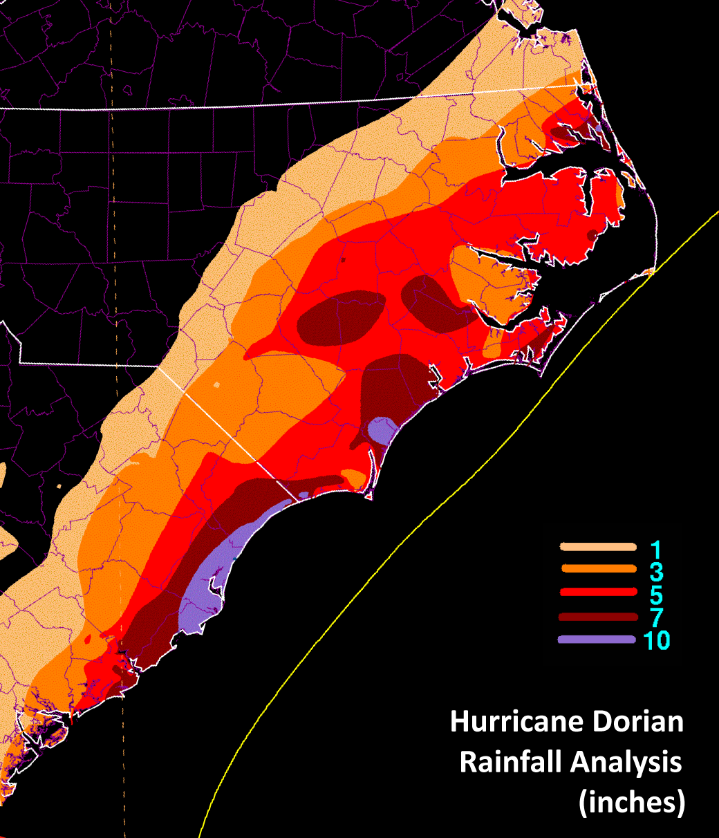
Hurricane Dorian rainfall totals in inches, produced by the NWS Weather Prediction Center. The yellow line is the path of Dorian's eye. |
Gauge-measured rainfall totals from local cities and volunteer observers from Hurricane Dorian
| North Carolina | Rainfall | South Carolina | Rainfall | |
| Wilmington 7.3 miles NE | 13.07 | Pawleys Island 5.6 miles NNE | 15.21 | |
| Wilmington 8.0 miles ENE | 12.25 | Pawleys Island 2.6 miles N | 14.80 | |
| Wilmington 6.7 miles NE | 12.13 | Litchfield by the Sea | 13.44 | |
| Wilmington 7.3 miles NE | 11.78 | Georgetown NWS Cooperative observer | 13.38 | |
| Castle Hayne | 11.40 | Myrtle Beach 5.2 miles SW | 12.77 | |
| Smith Creek 0.8 miles E | 11.36 | Georgetown 11.2 miles SW | 12.10 | |
| NWS Wilmington Office (not ASOS) | 10.80 | Pawleys Island 2.7 miles W | 12.00 | |
| Wilmington Kings Grant neighborhood | 10.24 | Myrtle Beach 9.2 miles WSW | 11.63 | |
| Wilmington ASOS | 10.05 | North Myrtle Beach ASOS | 10.74 | |
| Wilmington 6.2 miles SSE | 9.68 | Myrtle Beach 2.4 miles ENE | 10.62 | |
| Sunset Beach 1.7 miles WNW | 9.55 | Winyah Bay-Oyster Landing | 10.49 | |
| Wilmington NWS cooperative observer | 9.30 | Surfside Beach 1.0 miles NE | 10.25 | |
| Sunset Beach | 8.93 | Pawleys Island 0.8 miles WNW | 10.20 | |
| Calabash 1.2 miles NNW | 8.78 | Socastee 3 mi miles NE | 10.18 | |
| Hampstead 4.1 miles WNW | 8.63 | Murrells Inlet 0.9 miles NNE | 10.13 | |
| Calabash 2 miles N | 8.30 | Myrtle Beach NWS Cooperative observer | 10.00 | |
| Calabash 1.9 miles NNE | 7.94 | Conway 10 miles NE | 9.96 | |
| Calabash Town Hall | 7.62 | Murrells Inlet 4.0 miles NE | 9.76 | |
| Bolivia 7.8 miles SW | 7.56 | Little River | 9.66 | |
| Bolivia 7.6 miles SW | 7.52 | Myrtle Beach 5.0 miles WNW | 9.58 | |
| Ocean Isle Beach 3 miles NW | 7.48 | Myrtle Beach Prestwick neighborhood | 9.54 | |
| Hampstead 0.3 miles NW | 7.30 | Myrtle Beach 8.4 miles WNW | 9.19 | |
| Leland 5.7 miles WSW | 7.19 | Pawleys Island 1.8 miles W | 9.10 | |
| Bolivia 8.0 miles SW | 7.04 | Myrtle Beach AWOS | 8.87 | |
| Wilmington 4.1 miles SE | 6.83 | Myrtle Beach 7.4 miles NNW | 8.15 | |
| Leland 3.5 miles SSW | 6.79 | Longs 1.3 miles NW | 7.63 | |
| Wilmington 2.3 miles SE | 6.77 | Myrtle Beach 8.4 miles WNW | 7.63 | |
| Elizabethtown 6.2 miles NW | 6.65 | Cherry Grove Beach | 7.48 | |
| Topsail Beach 2.1 miles W | 6.56 | Conway 5 miles W | 7.43 | |
| Burgaw 0.3 miles NE | 6.40 | Pawleys Island 3.9 miles WNW | 7.25 | |
| Shallotte River 2 miles inland | 6.25 | Conway 9.2 miles NNE | 7.11 | |
| Holly Shelter/Back Island RAWS | 6.21 | Black Creek near Longs | 7.10 | |
| Green Swamp RAWS | 6.09 | Horry County RAWS | 6.89 | |
| Lake Waccamaw 3.9 miles SE | 6.05 | Crabtree Swamp at Conway | 6.72 | |
| Shallotte NWS Cooperative observer | 6.01 | Andrews NWS Cooperative observer | 6.20 | |
| Surf City 2.8 miles WSW | 5.81 | Hemingway SC DOT | 5.95 | |
| Hampstead 2.3 miles ENE | 5.55 | Loris 2 miles NW | 5.82 | |
| Wilmington 3.7 miles S | 5.53 | Longs NWS Cooperative observer | 5.39 | |
| Southport 5.9 miles W | 5.46 | Kingstree 6.9 miles SE | 4.74 | |
| Wilmington 2.8 miles SE | 5.43 | Gallivants Ferry NWS Coop observer | 4.56 | |
| Black River near Currie | 5.42 | Myrtle Beach 5.0 miles NNW | 4.30 | |
| Oak Island 2.3 miles E | 5.23 | Loris 1.4 miles ENE | 4.25 | |
| Carolina Beach 0.4 miles WSW | 5.10 | Loris Farm at Fox Bay | 4.21 | |
| Kure Beach | 5.06 | Marion 2.2 miles S | 4.11 | |
| Turnbull Creek RAWS | 4.93 | Marion RAWS | 4.08 | |
| Carolina Beach St. Joseph St. | 4.92 | Mullins NWS Cooperative observer | 4.04 | |
| Burgaw Edgewood | 4.84 | Green Sea | 3.92 | |
| Lumberton 2.3 miles NE | 4.80 | Marion NWS Cooperative observer | 3.88 | |
| Southport 1.0 miles NE | 4.79 | Kingstree 2.6 miles NNE | 3.80 | |
| Carolina Beach 1.0 miles N | 4.75 | Coward 5.1 miles NNW | 3.74 | |
| Long Beach 2.9 miles NE | 4.74 | Kingstree 7.9 miles NW | 3.70 | |
| Bolivia 4 miles SSE | 4.73 | Dillon 3.8 miles NW | 3.63 | |
| White Lake Marina | 4.66 | Kingstree 9.5 miles NW | 3.63 | |
| St. Pauls | 4.65 | Scranton 7.4 miles W | 3.53 | |
| Southport 2.7 miles NNW | 4.60 | Reaves Ferry | 3.35 | |
| Bladenboro 2.0 miles NNW | 4.59 | Cades NWS Cooperative observer | 3.30 | |
| Sunny Point RAWS | 4.58 | Marion AWOS | 3.25 | |
| Topsail Beach Fire Dept | 4.57 | Florence 2.2 miles ESE | 2.95 | |
| Oak Island 0.9 miles ENE | 4.54 | Florence Womack Gardens neighborhood | 2.94 | |
| Southport 0.9 miles NE | 4.50 | Florence 2.1 miles SW | 2.90 | |
| Whiteville NWS Cooperative observer | 4.42 | Florence West Lakes neighborhood | 2.87 | |
| Wilmington State Port | 4.27 | Florence ASOS | 2.68 | |
| Lumberton 8.6 miles SSE | 4.20 | Florence 1.2 miles NNE | 2.67 | |
| Holden Beach West End | 4.14 | Florence Kingsgate neighborhood | 2.55 | |
| Pembroke NWS Cooperative observer | 4.09 | Florence 6.1 miles W | 2.46 | |
| Whiteville RAWS | 4.09 | Florence 5.1 miles W | 2.43 | |
| William O Huske Lock & Dam | 4.02 | Darlington 7.3 miles SSW | 2.20 | |
| Chadbourn 1.1 miles NNW | 3.94 | Darlington NWS Cooperative observer | 1.97 | |
| Whiteville 6.1 miles NW | 3.89 | Clio 1.5 miles NW | 1.92 | |
| Elizabethtown 6.6 miles NW | 3.80 | Clio 1.6 miles WNW | 1.91 | |
| Cape Fear River Lock & Dam 1 | 3.79 | Darlington 0.3 miles ENE | 1.86 | |
| Lumberton RAWS | 3.76 | Clio 2 miles NE | 1.80 | |
| Lumberton 2.6 miles ESE | 3.67 | Hartsville 7 miles NE | 1.52 | |
| Carolina Beach-Myrtle Grove Sound | 3.48 | Bennettsville Emergency Ops Center | 1.12 | |
| Lumberton 3 miles north | 3.40 | Hartsville NWS Cooperative observer | 1.00 | |
| Caswell Beach | 2.67 | Bennettsville NWS Cooperative observer | 0.97 | |
| Lumberton NWS cooperative observer | 2.51 | Kingstree NWS Cooperative observer | 0.96 | |
| Pembroke | 2.36 | Hartsville 1.8 miles W | 0.88 |
Peak Wind Gusts During Hurricane Dorian
| North Carolina | Peak Gust (mph) | Marine | Peak Gust (mph) | |
| Federal Point (Weatherflow) | 75 | 41013-Frying Pan Shoals Buoy | 89 | |
| Fort Fisher Battle Acre Rd (Weatherflow) | 75 | 41037-Wrightsville Beach Offshore Buoy | 78 | |
| Southport Waterfront Park | 70 | Johnnie Mercer Pier | 69 | |
| Surf City Pier | 70 | 41038-Wrightsville Beach Nearshore Buoy | 67 | |
| Southport - Cape Fear Pilots | 69 | 41024-Sunset Beach Nearshore Buoy | 65 | |
| Sunset Beach | 65 | |||
| Sunny Point RAWS | 63 | South Carolina | Peak Gust (mph) | |
| Caswell Beach | 61 | Winyah Bay (Weatherflow) | 88 | |
| Oak Island | 61 | Murrells Inlet (Weatherflow) | 64 | |
| Carolina Beach-Myrtle Grove Sound | 61 | Myrtle Beach Prestwick neighborhood | 63 | |
| Kure Beach | 60 | Georgetown | 63 | |
| Carolina Beach Publix (Weatherflow) | 60 | North Myrtle Beach ASOS | 61 | |
| Bald Head Island | 56 | Georgetown AWOS | 55 | |
| Wilmington ASOS | 56 | Socastee 3 mi NE | 55 | |
| Calabash 2 mi N | 54 | Myrtle Beach AWOS | 54 | |
| Shallotte River 2 mi inland | 54 | Cherry Grove Beach | 54 | |
| Carolina Beach St. Joseph St. | 54 | Conway 5 mi W | 53 | |
| Topsail Beach Fire Dept | 53 | Lake Arrowhead | 52 | |
| Holly Shelter/Back Island RAWS | 52 | Little River | 50 | |
| Green Swamp/Nature Conservancy RAWS | 50 | Florence ASOS | 48 | |
| Ocean Isle Beach 3 mi NW | 50 | Marion AWOS | 45 | |
| Wilmington State Port | 48 | Loris Farm at Fox Bay | 43 | |
| Lumberton RAWS | 48 | Conway 10 miles NE | 42 | |
| Burgaw Edgewood neighborhood | 48 | Kingstree AWOS | 41 | |
| Holden Beach West End | 47 | Loris 2 miles NW | 41 | |
| Castle Hayne | 46 | Conway AWOS | 40 | |
| White Lake Marina | 45 | Horry County RAWS | 40 | |
| Calabash Town Hall | 45 | Litchfield by the Sea | 38 | |
| Whiteville | 38 | Marion RAWS | 37 |
Minimum Barometric Pressure Observed during Hurricane Dorian
| Location | millibars | in. Hg |
| 41013-Frying Pan Shoals Buoy | 958.5 | 28.30 |
| 41037-Wrightsville Beach Offshore Buoy | 959.2 | 28.33 |
| 41038-Wrightsville Beach Nearshore Buoy | 976.4 | 28.83 |
| Bald Head Island | 976.7 | 28.84 |
| Federal Point (Weatherflow) | 979.0 | 28.91 |
| Fort Fisher Battle Acre Rd (Weatherflow) | 980.0 | 28.94 |
| Southport Cape Fear Pilots | 981.7 | 28.99 |
| Carolina Beach Publix (Weatherflow) | 982.0 | 29.00 |
| Winyah Bay Range A Rear Light (Weatherflow) | 982.0 | 29.00 |
| Carolina Beach St. Joseph St. | 982.1 | 29.00 |
| Caswell Beach | 982.4 | 29.01 |
| Kure Beach | 982.7 | 29.02 |
| Wrightsville Beach-Johnnie Mercer Pier | 983.6 | 29.05 |
| Topsail Beach Fire Dept | 984.4 | 29.07 |
| Wilmington-Kings Grant neighborhood | 985.8 | 29.11 |
| Bolivia 4 miles SSE | 985.8 | 29.11 |
| Holden Beach-West End | 986.1 | 29.12 |
| Ocean Isle Beach 3 miles NW | 986.5 | 29.13 |
| Shallotte River 2 miles inland | 986.5 | 29.13 |
| Wilmington ASOS | 986.5 | 29.13 |
| Sunset Beach | 986.8 | 29.14 |
| Winyah Bay-Oyster Landing | 987.0 | 29.15 |
| Castle Hayne | 987.6 | 29.16 |
| Socastee 3 miles NE | 987.8 | 29.17 |
| Myrtle Beach-Prestwick neighborhood | 987.8 | 29.17 |
| Georgetown AWOS | 988.5 | 29.19 |
| Little River | 988.8 | 29.20 |
| Cherry Grove Beach | 988.8 | 29.20 |
| North Myrtle Beach AWOS | 989.5 | 29.22 |
| Myrtle Beach AWOS | 989.5 | 29.22 |
| Calabash Town Hall | 989.5 | 29.22 |
| Litchfield by the Sea | 989.8 | 29.23 |
| BurgaweEdgewood neighborhood | 991.2 | 29.27 |
| White Lake Marina | 992.9 | 29.32 |
| Conway AWOS | 993.2 | 29.33 |
| Whiteville AWOS | 994.9 | 29.38 |
| Elizabethtown AWOS | 997.6 | 29.46 |
| Marion AWOS | 998.6 | 29.49 |
| Florence ASOS | 1000.4 | 29.54 |
Confirmed Tornado Touchdowns on September 5, 2019
(in chronological order of touchdown time)
LITTLE RIVER, SC              HORRY COUNTY      4:37 AM - 4:48 AM     EF1

The tornado touched down in Little River around 4:37 AM
EDT. The earliest observed damage occurred to a dock and several
large trees near the end of Park Road at the Intracoastal
Waterway. One large section of wooden dock was thrown
approximately 150 yards. Several trees in the Little River area
south of U.S. Highway 17 were uprooted, broken and snapped.

The tornado crossed US Highway 17 around 4:39 AM EDT and
continued to damage the neighborhood on the north side of Little
River. Several hardwood trees and pines were snapped with shingle
damage to area homes consistent with EF-1 damage and 105 mph wind
speeds. Around 4:42 AM EDT, the tornado crossed through several
housing developments near Horseshoe Road in the vicinity of River
Hills Golf course where tree damage continued. After crossing
Eagles Nest Golf Course and Golf Avenue, trees were snapped on
the west side of the golf course before tracking into swamp land
north of Heritage Trust Road.

After passing through the swamp, damage resumed in The Retreat
neighborhood along Retreat Place. Shingle, siding damage to homes,
and partial roof loss were observed in The Retreat neighborhood
along with uprooted tree damage. The tornado crossed State Highway
57 North and snapped large pines and some hardwood trees, as caused
shingle damage to the nearby homes, consistent with EF-1 damage.
The tornado continued and crossed Highway 9 East and damaged
trees and shingles at Community Motors. Damage continued near
Surfride Blvd with an awning ripped off the local strip mall. The
tornado likely dissipated around 4:48 AM EDT.
Some damage from possible tornado in Little River SC this morning. #dorian #HurricaneDorian pic.twitter.com/mtm90hvV8x
— Jason Lee (@TSN_JLee) September 5, 2019
Found another nice screen grab of the first tornado of the day we had early this morning in Cherry Grove. The tornado was illuminated from power flashes as it passed through the retreat place subdivision in Little River, South Carolina, damaging numerous homes. pic.twitter.com/CM46pZ7aDY
— ☈ Chris Jackson ☈ (@ChrisJacksonSC) September 6, 2019
NWS Doppler radar loop showing the thunderstorm which spawned a tornado in Little River, SC early in the morning of September 5, 2019. This loop runs from 4:27 AM through 4:48 AM EDT.
SUNNY POINT MIL TERMINAL, NC  BRUNSWICK CO.    5:19 AM - 5:25 AM      EF0

A waterspout was observed crossing the Cape Fear River and
moved onshore at the Military Ocean Terminal Sunny Point complex.
The tornado caused tree damage as it moved across wooded areas of
the facility. Wind were estimated to have reached up to 80 mph
along a 5 mile path.
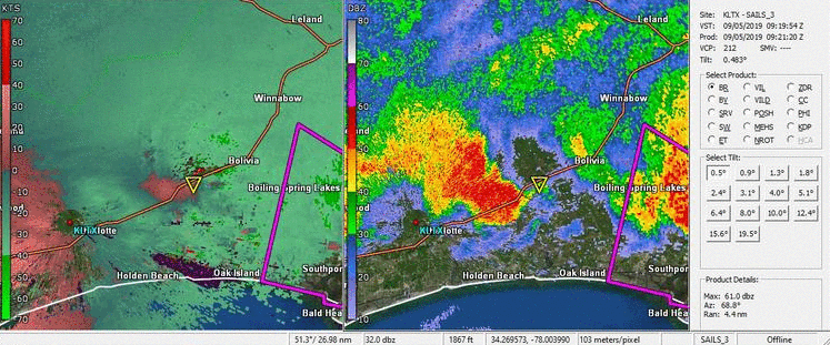
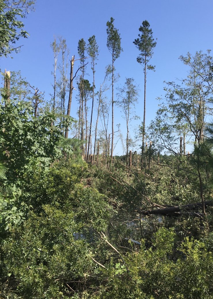
GREEN SWAMP PRESERVE, NC      BRUNSWICK CO.    5:23 AM - 5:26 AM    EF1

Damage was first observed from the end of Middle River Road Northeast where
about a dozen trees up to 14 inches in diameter were snapped along with
a few smaller hardwoods. From this point the tornado tracked over rural
and inaccessible swamp land towards Highway 211. On the east side of 211,
approximately 50 large pine trees were snapped in an area about 50 yards
wide. Several trees fell across Highway 211, and a few additional smaller
trees were snapped on the west side. Little significant damage was
observed west of 211. Estimated wind speeds reached 105 mph. Path length
was 2.25 miles and the maximum path width was 50 yards.
NWS Doppler radar images of the thunderstorm that produced an EF1 tornado in the Green Swamp Preserve near Supply in Brunswick County, NC. This image loop runs from 5:21 AM to 5:38 AM EDT on September 5, 2019.
3 MILES WSW SOCASTEE, SC      HORRY COUNTY      5:45 AM - 5:46 AM     EF0

A funnel cloud touched down in the Riverbend neighborhood 3 miles west-
southwest of Socastee. Several fascia boards were torn off one
of the condos and two 24 inch oak trees were partially uprooted. Based on
observed damage the estimated maximum wind speed was 65 mph, with a path
length of 0.1 miles.
MYRTLE GROVE, NC             NEW HANOVER CO.   5:58 AM - 6:02 AM    EF0

A tornado initially impacted the SE Harbor Dr area with large
limbs blown down. The tornado moved west-northwest breaking numerous
large limbs. It crossed Myrtle Grove Rd breaking additional large
tree limbs and uprooting a few trees up to 3 feet diameter. Shingles
were also blown off a shed in this area. The tornado lifted on the north
side of Grove Point Rd.
WILMINGTON-BURNT MILL CREEK, NC  NEW HANOVER CO.  6:17 AM - 6:22 AM   EF0

A weak tornado with winds generally 55 to 65 mph caused mainly minor
damage to trees on its path across an urban residential area. The
tornado touched down near Wrightsville Ave at Eisenhower Ave and moved
northwest across the Burnt Mill Creek area. Minor tree damage continued
as the tornado crossed Wilmington National Cemetery. The tornado
dissipated near the west end of Klein Road.
LIVINGSTON CREEK, NC          COLUMBUS COUNTY   6:37 AM - 6:41 AM     EF0

A tornado formed just northeast of the intersection of Bordeux Rd
and Delco Prosper Rd where several large branches were broken. The
tornado then traveled northwest close to Livingston Chapel Rd, and
produced significant roof damage on a double wide manufactured home
and flipped a trailer over. Trees were also snapped along the way,
and damage continued until the tornado lifted shortly after passing
Connor Rd. This tornado had a path length of 2.1 miles, a maximum
width of 50 yards, and had wind speeds up to 85 mph.
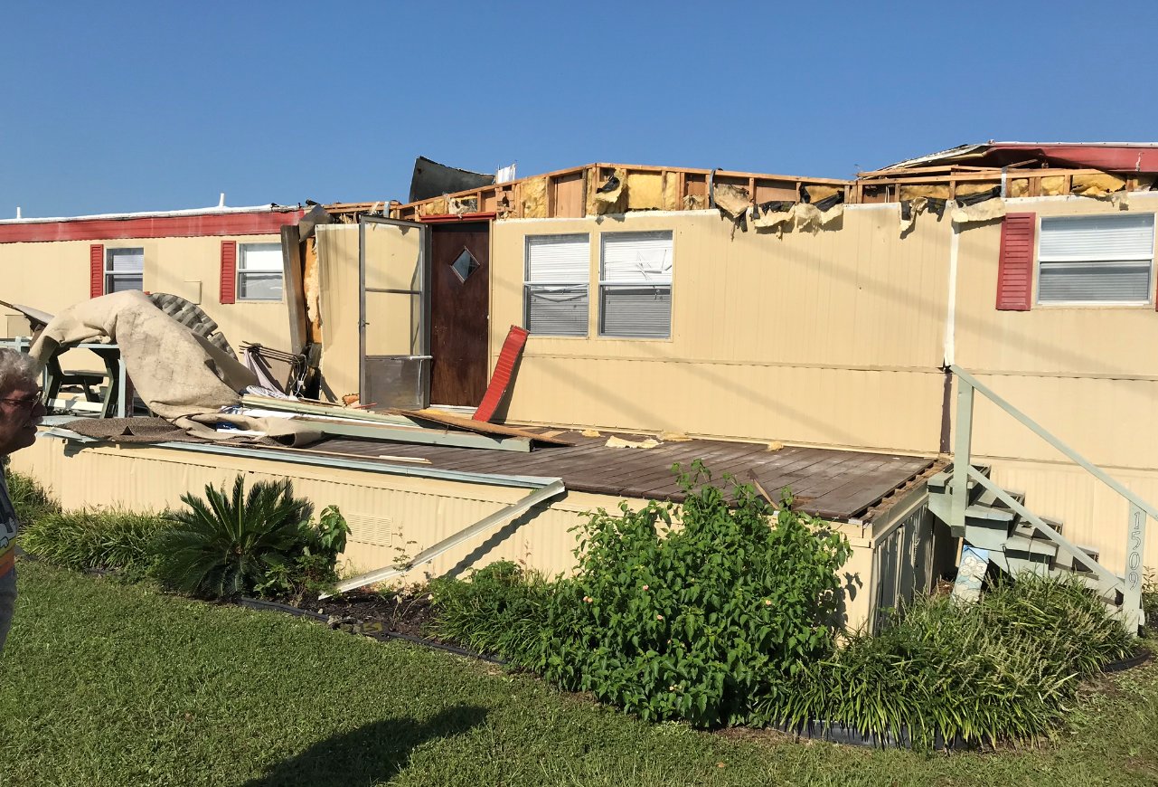
NORTH MYRTLE BEACH, SC        HORRY COUNTY     6:37 AM - 6:38 AM     EF0

A tornado touched down on Beacon Ave in Waterway View Mobile Home
Park, moving toward the west-southwest. The worst damage was
observed between Tanglewood Ave and Gardenia Ave where 2 mobile
homes were severely damaged. A shed was pushed into another
mobile home and a telephone pole was tiled by the wind. Minor
damage occurred to another six mobile homes before the tornado
exited Waterway View Mobile Home Park and moved into an adjacent
neighborhood, Carolina Keyes condominiums, where considerable
damage was done to the exterior of several buildings. Minor
roof damage also occurred.
Video from North Myrtle Beach shows possible tornado Thursday morning as Hurricane Dorian continues to move closer to land. https://t.co/ml60uCLB43 pic.twitter.com/BP38IMl87o
— ABC11 EyewitnessNews (@ABC11_WTVD) September 5, 2019
Tornado damage occurred to at least eight trailers at the Waterway View Mobile Home Park in North Myrtle Beach. (Photo credit: NWS)
WILMINGTON-GORDON ROAD, NC    NEW HANOVER CO.   6:39 AM - 6:41 AM     EF0

A short-lived tornado impacted the Brookfield neighborhood near
Gordon Rd in Wilmington. The tornado formed just south of
Stones Edge Loop causing some damage to trees. The tornado moved
across Northbrook Rd and knocked large limbs down. It also caused
the walls to buckle at a home along Northbrook Rd., destroyed a
nearby shed, and knocked several large limbs out of a large tree.
The tornado moved northwest causing damage to an old shed on the
south side of Briercrest Dr. The tornado then crossed Briercrest
Dr. causing minor damage to a home and knocking large limbs out of
trees. The tornado lifted in the vicinity of Gordon Rd. east of
North Kerr Ave. Maximum winds were estimated around 80 mph along the
tornado's 0.3 mile path length.
6 MILES SOUTH OF BOLTON, NC   COLUMBUS COUNTY   6:53 AM               EF0

A large section of a hardwood tree was broken out at Pineview Veterinary
Hospital at Green Swamp Road.  A few additional hardwood trees were blown
over along the east side of NC Highway 211.  Estimated wind speed was
75 mph, making this an EF0 tornado.
SCOTTS HILL, NC               PENDER COUNTY     6:56 AM - 7:02 AM     EF0

A tornado formed near Scott's Hill Animal Hospital and moved west-
northwest across Highway 17. The tornado caused some structural
damage to Scott's Hill Market and some minor damage to homes
primarily along the west side of Pandy Ann Ln. There were several
trees uprooted along the road. The tornado lifted as it entered
the woods near the end of Pandy Ann Ln.
Video of a tornado passing near Pender County Fire Station 18 along Highway 17 near Sidbury Rd. Video courtesty of Station 18. Time was around 6:55-7:00 AM EDT Thursday Sept 5, 2019 pic.twitter.com/RRFhZuL47l
— NWS Wilmington NC (@NWSWilmingtonNC) September 5, 2019
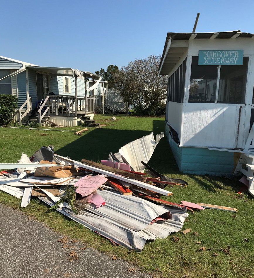
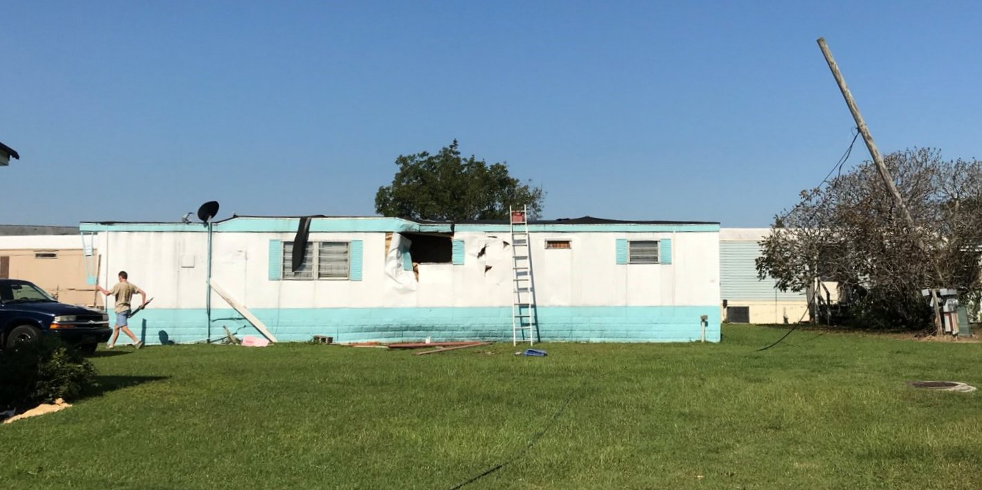
SUNSET BEACH/CAROLINA SHORES, NC  BRUNSWICK CO.  6:58 AM - 7:17 AM    EF2

Video shared on social media showed this tornado moved onshore near
Tubbs Inlet. The tornado moved northwest causing moderate tree
damage and minor roof damage as it crossed Sunset Blvd North near
Sunset Beach Town Hall. Spotty tree and roof damage continued as
the tornado crossed Sea Trail Golf Resort and moved into a large
wooded area north of Old Georgetown Road SW (Hwy 179). To this
point along the path, damage was consistent with wind speeds in
the 80-90 mph range (EF-0/EF-1).

The tornado continued near Bennett Trail SW at the intersection of
Thomasboro Road and caused major roof damage to a few homes and a
horse barn. Large sections of roofs were blown off, and numerous
large trees were snapped as the tornado approached The Farms at
Brunswick community. In this area, the tornado strengthened to
EF-2 with a width of approximately 200 yards. Damage in The Farms
was extensive. Several dozen homes received minor to major damage
along Carolina Farms Blvd, Slippery Rock Way, Fence Post Lane and
Castle Run Lane. The tornado reached maximum intensity as it
crossed Slippery Rock Way near Fence Post Lane, where large
sections of roofs were blown off. There were several instances of
lumber piercing both exterior and interior walls of houses. The
only known injury, a broken arm, occurred in this area.

The tornado exited The Farms at Brunswick and crossed Highway 17
just south of the intersection of Hickman Road (Hwy 57). Two open
air carports and a metal garage were destroyed on the north side
of Highway 17. It crossed the holes 14-16 of Crow Creek Golf
Club, snapping numerous large pine trees and causing minor roof
damage to homes along Honey Tree Lane. The tornado crossed
Hickman Road behind Beulah Baptist Church, traversed the north
end of Green Pastures Lane, and snapped numerous large hardwood
and pine trees throughout private game land. It caused minor
damage to a farmhouse and destroyed a chicken coop before crossing
Ash Little River Road NW. Numerous trees were snapped and uprooted
on the west side of Ash Little River Road NW as the tornado moved
into swampland near the Waccamaw River. Damage along and north of
Hickman Road was consistent with maximum winds of 90-100 mph
winds (EF-1).
|
NWS Doppler radar images from 6:55 AM to 7:16 AM on September 5, 2019. The thunderstorm that produced the tornado in Sunset Beach and Carolina Shores moves onshore while producing a waterspout. The resulting tornado moves northwestward across Carolina Shores and dissipates in woodlands near the Waccamaw River. |
||
|
KELLY, NC                     BLADEN COUNTY     7:21 AM - 7:26 AM     EF0

A tornado traveled along a 5 mile path along Natmore Rd, mainly
along the north side of the highway. Damage was limited to broken
large tree limbs, a few uprooted hardwood trees, and minor roof
damage at the Kelly museum.
SHAW HIGHWAY/ST. HELENA, NC   PENDER COUNTY     7:45 AM - 7:53 AM     EF0

The tornado touched down near Shaw Highway northeast of Burgaw
with isolated damage between here and St. Helena. The tornado
moved northwest toward the St. Helena area. The area with the
most significant damage was off US highway 117 in St. Helena. An
NWS storm survey team rated this tornado as an EF0 with winds of
70 mph. Path length was 7.1 miles and the maximum width was 30
yards. Time estimated via radar.
PORTERS NECK, NC              NEW HANOVER CO.   11:48 AM - 11:52 AM   EF1

A waterspout moved ashore over the northern end of Figure Eight
Island, causing EF0-rated damage to a couple of beachfront homes
and trees. The tornado track was evident across the marsh towards
the Intracoastal Waterway, where it affected Bald Eagle Ln. On
Bald Eagle Ln area there was one injury, numerous trees snapped
and uprooted, and mostly minor damage to homes. The tornado
moved northwest towards Fazio Dr where its damage path expanded to
100 yards in width. Winds also reached an estimated 100 miles per hour.
Here the tornado caused roof damage and snapped large trees near the
Porter's Neck golf course. The tornado continued to move northwest to
Futch Creek Rd and Plantation Landing Dr where it lifted after
producing additional EF0 damage, mainly to trees.
@NWSWilmingtonNC I found the tornado damage track. See location in comments. Siding/shingles/downspouts strewn about with tree and roof damage! I watched this cross the highway. #ncwx #HurricaneDorian #Tornado @ReedTimmerAccu @southernon_wx @WXgage pic.twitter.com/WD2BFS0KYc
— David Piano (@ONwxchaser) September 5, 2019
NWS Doppler radar images of the thunderstorm that produced the Porters Neck tornado. A tornadic waterspout moved onshore at Figure Eight Island and into the Porters Neck community. After crossing U.S. Highway 17 and damaging an apartment complex, a strong radar-indicated circulation continued aloft across northern New Hanover County.
LONG CREEK, NC                PENDER COUNTY     12:19PM - 12:24 PM    EF0

A tornado formed near Forest Lane, where several large tree
branches were broken. The tornado continued off to the northwest,
where EF0 damage was also seen at Clarks Landing Loop Rd due to
several snapped trees near a field. Low-end EF1 damage was then
observed on Long Creek Loop Rd where softwood trees were snapped.
The tornado continued off to the northwest where damage was
limited to broken tree limbs, before lifting near Herrings Chapel
Rd and Mulberry Ln.
HOLLY SHELTER/HIGHWAY 53, NC  PENDER COUNTY    1:10 PM - 1:15 PM      EF0

A tornado was likely already on the ground within the Holly Shelter
Gameland area as it moved onto Old Maple Hill Rd south of
Highway 53, causing trees to be snapped. (Holly Shelter was
inaccessible during the damage survey) The tornado moved toward
the west-northwest, crossing Shaw Highway near Old Blakes Bridge
Rd. causing some minor tree damage. The tornado then crossed
Highway 53 causing additional tree damage. The tornado finally
lifted near Croomsbridge Rd north of Highway 53 in the Shelter
Neck area. Maximum winds were estimated to have reached 70 mph with
a path length of 4.4 miles.
Links
National Hurricane Center Hurricane Dorian Advisory Archive
National Weather Service Charleston, SC Hurricane Dorian summary page
National Weather Service Newport/Morehead City, NC Hurricane Dorian summary page
Page Author: Tim Armstrong
Last Updated: January 25, 2020


 Coastal Flood