NOAA recently released its official outlook for the 2019-2020 Winter season.
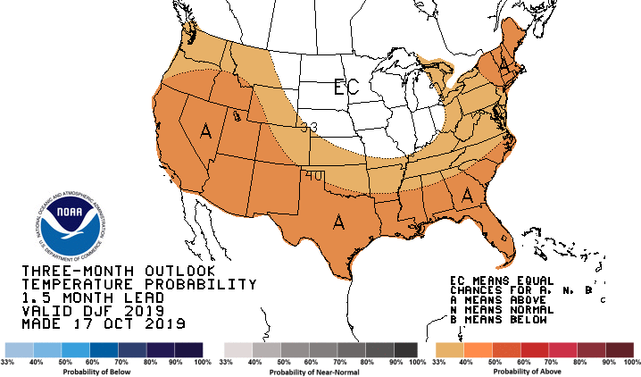
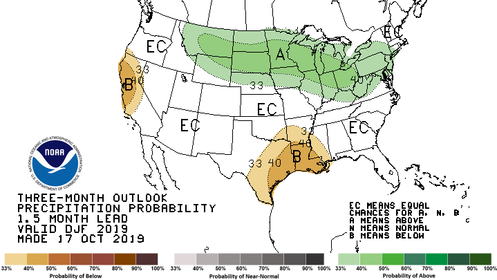
For the Carolinas, temperatures this winter will have an enhanced potential to run above normal, while precipitation has equal chances to be below, near, or above normal during December, January, and February.
|
NWS Climate Prediction Center temperature outlook for Winter 2019-2020. Orange shading indicates enhanced potential for above normal temperatures. |
NWS Climate Prediction Center precipitation outlook for Winter 2019-2020. "EC" indicates equal chances for below, near, or above normal precipitation. |
|
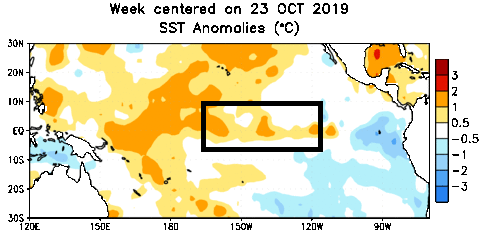
Water temperatures across the Nino 3.4 region of the tropical east Pacific are only slightly above normal, and should be near normal through our upcoming winter season. |
El Nino and La Nina events can bring big departures in winter temperatures and rainfall across the Carolinas.
El Nino occurs when water temperatures across the tropical east Pacific are warmer than normal. This typically creates a cool and wet winter across the Southern United States including the Carolinas. During La Nina events, water temperatures across the tropical east Pacific are cooler than normal. This typically creates a dry, warm winter across the Carolinas.
Ocean temperatures within the tropical east Pacific are expected to run near normal this winter. Without El Nino (warm water) or La Nina (cold water) present, the largest factor that influences the wintertime climate of the Carolinas will be missing. However there are two other climate factors that lend at least some predictability to upcoming winter temperatures: the Atlantic Multidecadal Oscillation (AMO), and recent observed trends in temperature.
Temperatures
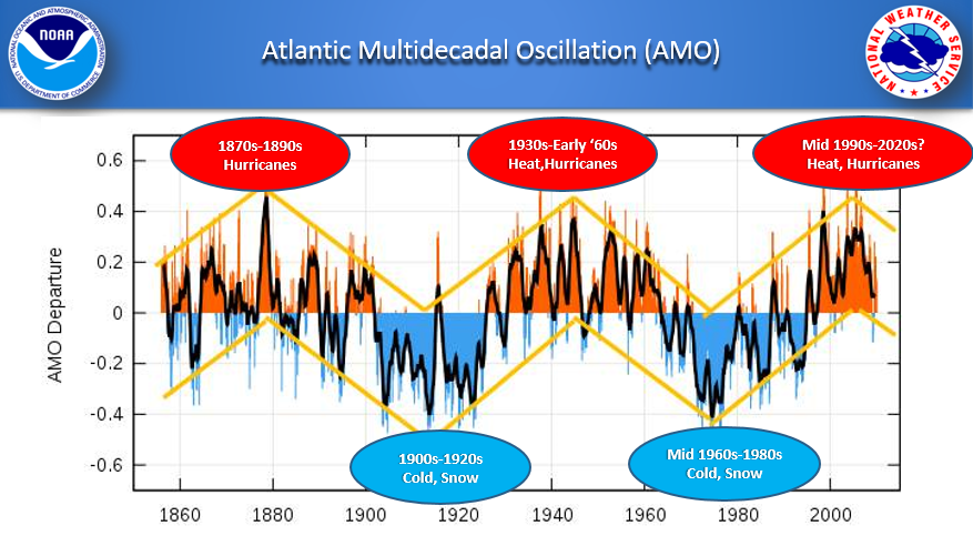
The Atlantic Multidecadal Oscillation (AMO) is a repeating climate pattern in water temperatures across the northern Atlantic Ocean. Water temperatures averaged across the North Atlantic Ocean rise and fall in a cycle measuring approximately 60 years in length. The AMO typically remains in a warm phase for 30 years, followed by 30 years in a cool phase. The AMO began its most recent warm phase 25 years ago during the mid-1990s, and this warm period may continue for a few more years. During a warm AMO, wintertime temperatures across the Carolinas tend to run mild with relatively few intense outbreaks of arctic cold. The reverse is true during the cold phase of an AMO when our winters have an increased potential to see frequent outbreaks of cold, arctic air.
|
The Atlantic Multidecadal Oscillation (AMO) has impacts on the climate of the Carolinas |
The observed trend in temperatures for all seasons, including winter, is upward across the Carolinas and across most of the globe. This is believed to be due to increased concentration of greenhouse gases in the atmosphere from the burning of fossil fuels. This ongoing trend toward warmer temperatures suggests an enhanced potential of warmer than normal temperatures for this upcoming winter.
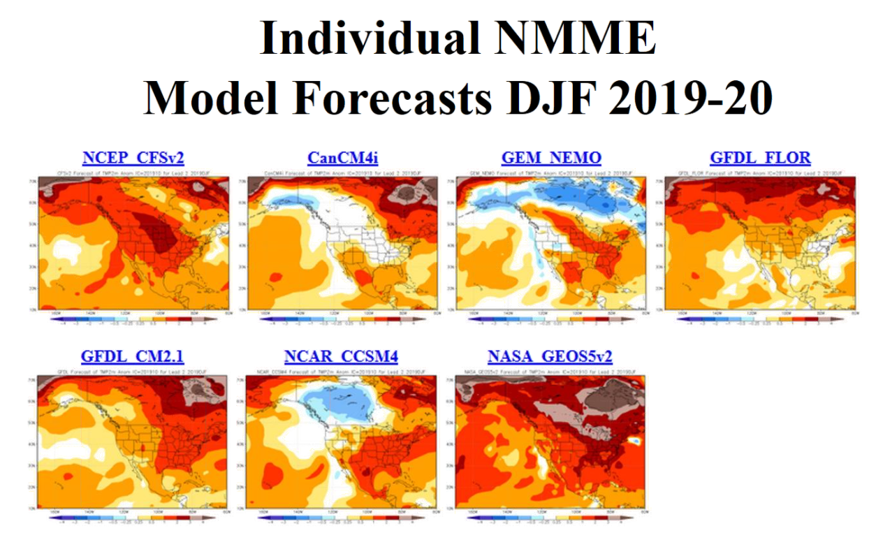
Five of the seven models used by climatologists at the NWS Climate Prediction Center are predicting a warmer than normal winter across the Carolinas. Two others are predicting near-normal temperatures. None predict below-normal temperatures.
|
|
The official NWS Climate Prediction Center outlook is for an enhanced potential of above-normal temperatures this winter.
Rainfall and River Flooding
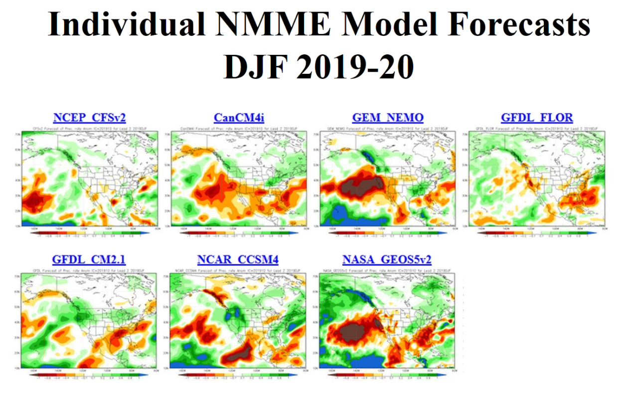
With the absence of El Nino or La Nina this winter, there is little predictability in seasonal winter rainfall across the Carolinas. Three of the seven climate models used by the NWS Climate Prediction Center show below-normal precipitation across the Carolinas, three show near-normal precipitation amounts, one is above-normal.
|
|
The official outlook for the winter is for equal chances of below, near, and above normal precipitation across North and South Carolina. This means there is no clear signal to favor higher or lower than normal rain chances for the coming winter season. “Normal” winter rainfall for our portion of the Carolinas is between 9 and 11 inches, distributed evenly across the three months of winter.
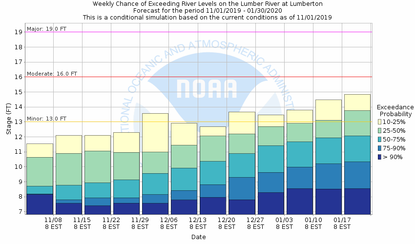
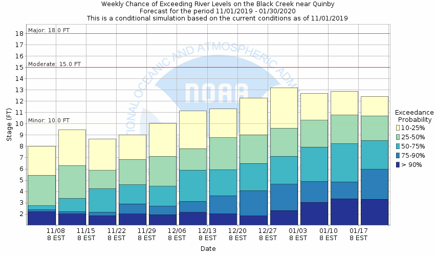
Even with uncertainty concerning rainfall this winter, multi-model blends for the upcoming winter can suggest how likely river flooding may become through January. Most rivers across our portion of the Carolinas should have low potential for flooding. This is due to persistently dry weather most of this year plus the relatively small chances for excessive rainfall this winter.
|
Flood risk on the Lumber River at Lumberton, NC through January 2020. Outlook made November 1, 2019. |
Flood risk on the Black Creek at Quinby, SC through January 2020. Outlook made November 1, 2019. |
The two locations with moderate potential to experience river flooding are the Lumber River at Lumberton, NC, and Black Creek near Quinby, SC, both shown above.
Updated outlooks of the potential for river flooding for all forecast points on the Cape Fear, Northeast Cape Fear, Lumber, Waccamaw, Pee Dee, Black, and Lynches rivers are available at this link: https://water.weather.gov/ahps2/long_range.php?wfo=ilm&percent=75
Other impacts
Even though temperatures are expected to run above normal for the winter as a whole, it is almost certain there will be short periods of arctic cold to descend across the Carolinas. During a typical winter minimum temperatures will drop into the upper teens or lower 20s at least once.
Snow is a rare event across the coastal portions of North and South Carolina, only averaging 1 to 2 inches per year. Given the relatively weak magnitude of the factors affecting our climate this winter, it is not possible to predict how seasonal snowfall might vary from normal.
Past Several Winters
|
Wilmington, NC
|
Florence, SC
|
North Myrtle Beach, SC
|
Research & Page Author: Tim Armstrong
Page Created: November 1, 2019
Last Updated: November 1, 2019


 Coastal Flood