
Scattered thunderstorms with severe gusts, hail and a tornado risk are possible near a cold front from the Ohio Valley to the Mid-Atlantic tonight. Tropical Storm Bertha is expected to bring tropical storm conditions to portions of the Gulf Coast from the panhandle of Florida into Louisiana through Wednesday. Read More >
Overview
|
Fast Facts:
|
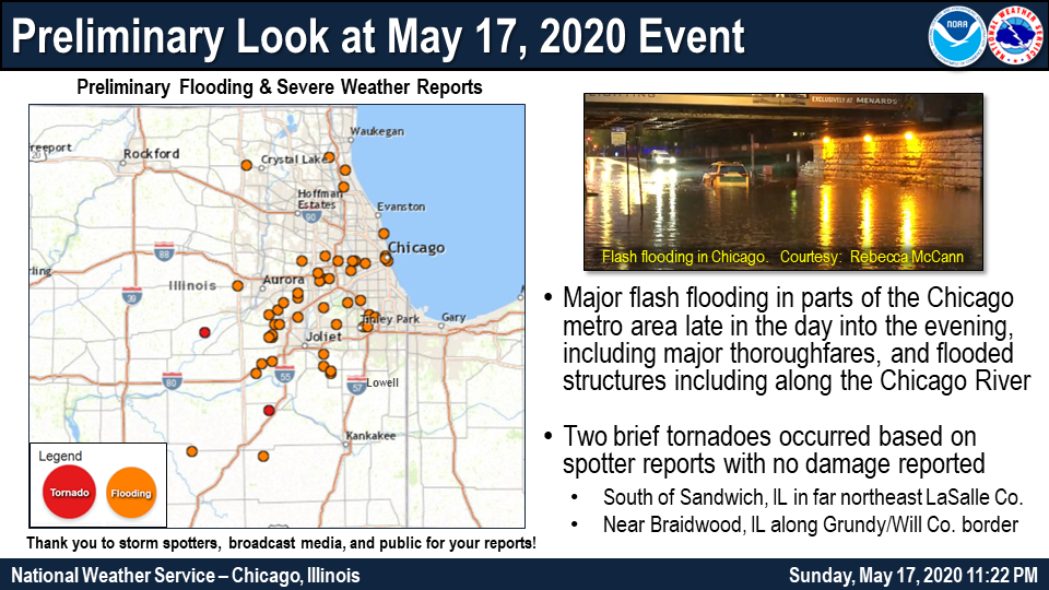 Widespread flash flooding across the Chicago metro area Sunday, May 17, 2020. |
Flooding and Storm Reports
PRELIMINARY LOCAL STORM REPORT...SUMMARY
NATIONAL WEATHER SERVICE CHICAGO IL


..TIME...   ...EVENT...      ...CITY LOCATION...     ...LAT.LON...
..DATE...   ....MAG....      ..COUNTY LOCATION..ST.. ...SOURCE....
            ..REMARKS..
1130 AM     FLOOD            1 NE GARDNER            41.19N 88.30W
05/18/2020                   GRUNDY             IL   EMERGENCY MNGR

            GRUNDY COUNTY EMERGENCY MANAGER REPORTS
            WATER RESCUE ONGOING IN THE VICINITY OF
            GARDNER.

1100 AM     FLOOD            4 ENE MORRIS            41.38N 88.36W
05/18/2020                   GRUNDY             IL   EMERGENCY MNGR

            GRUNDY COUNTY EMERGENCY MANAGER REPORTS
            NUMEROUS WATER RESCUES HAVE OCCURRED ALONG
            CEMETERY ROAD OVER THE LAST SEVERAL HOURS.
            TIME APPROXIMATE.
0850 PM     FLASH FLOOD      1 NNW CHICAGO LOOP      41.89N 87.64W
05/17/2020                   COOK               IL   LAW ENFORCEMENT

            RESIDENTIAL STRUCTURE FLOODING ALONG
            KINGBURY STREET FROM THE NB CHICAGO RIVER.

0847 PM     FLOOD            1 ESE CRESTWOOD         41.65N 87.73W
05/17/2020                   COOK               IL   EMERGENCY MNGR

            CAL-SAG ROAD CLOSED DUE TO FLOODING BETWEEN
            CICERO AVENUE AND 135TH STREET. UNKNOWN
            DEPTH. RELAYED VIA AMATUER RADIO OPERATOR.

0845 PM     HEAVY RAIN       4 NNW PLAINFIELD        41.67N 88.23W
05/17/2020  M3.13 INCH       WILL               IL   NWS EMPLOYEE

            3.13 INCHES OF RAINFALL OVER APPROXIMATELY
            24 HOURS.
0830 PM     FLASH FLOOD      1 S JOLIET              41.51N 88.08W
05/17/2020                   WILL               IL   TRAINED SPOTTER

            IL-53 PAVEMENT CHUNKS DAMAGED NEAR I-80 DUE
            TO FLASH FLOODING. TIME ESTIMATED.
0825 PM     FLOOD            FOREST PARK             41.87N 87.81W
05/17/2020                   COOK               IL   UNKNOWN

            CHICAGO CTA REPORTS VIA SOCIAL MEDIA L-TRAIN
            SERVICE SHUT DOWN BETWEEN HARLEM AVENUE AND
            FOREST PARK STATION DUE TO FLOODING.

0813 PM     FLASH FLOOD      1 NNE WHEATON           41.87N 88.10W
05/17/2020                   DUPAGE             IL   PUBLIC

            VIDEO SHARED VIA SOCIAL MEDIA SHOWS PARK
            FLOODED WITH SEVERAL FEET OF WATER NEAR
            DOWNTOWN WHEATON.

0811 PM     FLOOD            1 W OAK FOREST          41.60N 87.76W
05/17/2020                   COOK               IL   LAW ENFORCEMENT

            NUMEROUS CARS STALLED DUE TO FLOODING AT
            159TH STREET AND CENTRAL AVENUE. DEPTH
            UNKNOWN. RELAYED VIA AMATEUR RADIO OPERATOR.

0805 PM     FLASH FLOOD      CHICAGO LOOP            41.88N 87.64W
05/17/2020                   COOK               IL   LAW ENFORCEMENT

            CARS STALLING IN FLOODWATERS ALONG LOWER
            WACKER DRIVE.

0800 PM     HEAVY RAIN       3 NNW LAKEWOOD          42.26N 88.40W
05/17/2020  M3.01 INCH       MCHENRY            IL   CO-OP OBSERVER

            EVENT TOTAL.

0800 PM     FLASH FLOOD      CHICAGO RIDGE           41.71N 87.78W
05/17/2020                   COOK               IL   PUBLIC

            PHOTO SHARED VIA SOCIAL MEDIA SHOWS FLOODING
            FROM STONY CREEK INUNDATING YARDS AND
            APPROACHING STRUCTURES NEAR RIDGELAND AVENUE
            AND 103RD STREET.

0755 PM     FLOOD            2 SW LAKE FOREST        42.24N 87.86W
05/17/2020                   LAKE               IL   PUBLIC

            PHOTO SHARED VIA SOCIAL MEDIA SHOWS US-41
            CLOSED DUE TO FLOODING AT IL-60.

0755 PM     FLOOD            CLARENDON HILLS         41.80N 87.95W
05/17/2020                   DUPAGE             IL   PUBLIC

            PHOTO SHARED VIA SOCIAL MEDIA SHOWS
            RESIDENTIAL STREET FLOODING AT LEAST 1FT
            DEEP IN CLARENDON HILLS.

0740 PM     FLOOD            1 WSW DEERFIELD         42.17N 87.87W
05/17/2020                   LAKE               IL   PUBLIC

            VIDEO SHARED VIA SOCIAL MEDIA SHOWS
            RESIDENTIAL STREET FLOODING NEAR DEERFIELD
            ROAD AND WILMOT ROAD.

0730 PM     FLOOD            2 W PLAINFIELD          41.61N 88.25W
05/17/2020                   WILL               IL   PUBLIC

            MULTIPLE REPORTS OF IL-126 CLOSED WEST OF
            PLAINFIELD DUE TO FLOODING.

0725 PM     HEAVY RAIN       1 N CICERO              41.86N 87.75W
05/17/2020  M1.80 INCH       COOK               IL   PUBLIC

            PRIVATE WEATHER STATION REPORTS 1.8 INCHES
            IN 1 HOUR PERIOD ENDING AT 725 PM.

0725 PM     FLASH FLOOD      FOREST PARK             41.87N 87.82W
05/17/2020                   COOK               IL   LAW ENFORCEMENT

            ISP REPORTS I-290 FLOODED NEAR DES PLAINES
            AVENUE IN FOREST PARK.

0710 PM     FLOOD            VILLA PARK              41.89N 87.97W
05/17/2020                   DUPAGE             IL   PUBLIC

            PHOTO SHARED VIA SOCIAL MEDIA SHOWS WATER AT
            LEAST 1FT DEEP ON RESIDENTIAL ROADWAYS IN
            VILLA PARK.

0710 PM     FLASH FLOOD      ROBBINS                 41.64N 87.70W
05/17/2020                   COOK               IL   DEPT OF HIGHWAYS

            COOK COUNTY DOT REPORTS KEDZIE AVENUE CLOSED
            BETWEEN 137TH STREET AND 139TH STREET DUE TO
            FLOODING.

0700 PM     FLASH FLOOD      2 WSW ROMEOVILLE        41.64N 88.12W
05/17/2020                   WILL               IL   PUBLIC

            PHOTO SHARED VIA SOCIAL MEDIA SHOWS SEVERAL
            INCHES OF WATER ON WEBER ROAD AT 135TH
            STREET.

0700 PM     HEAVY RAIN       6 SSW NAPERVILLE        41.70N 88.20W
05/17/2020  M2.60 INCH       WILL               IL   PUBLIC

            PRIVATE WEATHER STATION REPORTS 2.6 INCHES
            OF RAIN IN 3-HR ENDING AT 7PM.

0700 PM     FLOOD            1 NNW SUGAR GROVE       41.77N 88.45W
05/17/2020                   KANE               IL   PUBLIC

            NUMEROUS PUBLIC REPORTS OF FLOODED ROADWAYS
            IN THE VICINITY OF SUGAR GROVE RELAYED VIA
            MPING.

0700 PM     FLASH FLOOD      1 ESE DOWNERS GROVE     41.79N 88.00W
05/17/2020                   DUPAGE             IL   DEPT OF HIGHWAYS

            VILLAGE OF DOWNERS GROVE REPORTS REPORTS VIA
            SOCIAL MEDIA 55TH STREET HAS BEEN CLOSED
            BETWEEN LYMAN AVENUE AND FLORENCE AVENUE DUE
            TO FLASH FLOODING OF ST. JOSEPH CREEK AND
            BARTH POND.

0700 PM     FLASH FLOOD      1 ENE DOWNERS GROVE     41.80N 87.99W
05/17/2020                   DUPAGE             IL   DEPT OF HIGHWAYS

            VILLAGE OF DOWNERS GROVE REPORTS VIA SOCIAL
            MEDIA FLASH FLOODING OF ST. JOSEPH CREEK HAS
            OVERTOPPED FAIRVIEW AVENUE. FAIRVIEW AVENUE
            CLOSED FROM MAPLE AVENUE TO PRAIRIE AVENUE.

0700 PM     FLASH FLOOD      2 N DOWNERS GROVE       41.82N 88.01W
05/17/2020                   DUPAGE             IL   DEPT OF HIGHWAYS

            VILLAGE OF DOWNERS GROVE REPORTS VIA SOCIAL
            MEDIA HIGHLAND AVENUE CLOSED NEAR 35TH
            STREET DUE TO FLOODING OF LACEY CREEK.

0650 PM     FLASH FLOOD      4 SW PLAINFIELD         41.57N 88.26W
05/17/2020                   WILL               IL   PUBLIC

            VIDEO SHARED VIA SOCIAL MEDIA SHOWS FLOODING
            MULTIPLE FEET DEEP ON RESIDENTIAL STREETS
            OFF COUNTY LINE ROAD.

0640 PM     FLASH FLOOD      1 WSW RIVERSIDE         41.83N 87.83W
05/17/2020                   COOK               IL   LAW ENFORCEMENT

            RIVERSIDE PD REPORTS 1ST AVENUE CLOSED NEAR
            FOREST AVENUE DUE TO A FLOODED UNDERPASS.

0630 PM     FLASH FLOOD      3 NW BOLINGBROOK        41.72N 88.12W
05/17/2020                   WILL               IL   NWS EMPLOYEE

            MULTIPLE VEHICLES STALLED DUE TO FLOODING
            ALONG NAPER BOULEVARD BETWEEN ROYCE ROAD AND
            BAILEY ROAD.

0630 PM     FLASH FLOOD      3 SE NAPERVILLE         41.74N 88.12W
05/17/2020                   DUPAGE             IL   NWS EMPLOYEE

            SEVERAL FEET OF WATER ON NAPER BOULEVARD
            NEAR BAILEY ROAD.

0625 PM     FLASH FLOOD      HILLSIDE                41.87N 87.90W
05/17/2020                   COOK               IL   PUBLIC

            WATER ON A FEW LANES OF I-290 NEAR I-294.

0615 PM     FLASH FLOOD      PLAINFIELD              41.61N 88.22W
05/17/2020                   WILL               IL   LAW ENFORCEMENT

            PLAINFIELD PD INDICATES VIA SOCIAL MEDIA
            THAT NUMEROUS ROADWAYS ARE FLOODED ACROSS
            THE VILLAGE.

0610 PM     FLASH FLOOD      1 N MINOOKA             41.46N 88.26W
05/17/2020                   KENDALL            IL   PUBLIC

            NUMEROUS REPORTS OF I-80 FLOODED NEAR RIDGE
            ROAD IN MINOOKA.

0605 PM     FLASH FLOOD      1 ENE LEMONT            41.68N 87.98W
05/17/2020                   COOK               IL   EMERGENCY MNGR

            MAIN STREET CLOSED DUE TO FLOODING FROM 4TH
            STREET TO WALKER ROAD EAST OF LEMONT.

0600 PM     HEAVY RAIN       4 SW PLAINFIELD         41.56N 88.26W
05/17/2020  M3.00 INCH       KENDALL            IL   PUBLIC

            PRIVATE WEATHER STATION SOUTHWEST OF
            PLAINFIELD REPORTS 3.0 INCHES OF RAIN IN 2
            HOURS ENDING AT 6PM.

0600 PM     HEAVY RAIN       3 W MINOOKA             41.45N 88.32W
05/17/2020  M3.50 INCH       GRUNDY             IL   PUBLIC

            PRIVATE WEATHER STATION WEST OF MINOOKA
            REPORTS 3.5 INCHES OF RAIN IN 2 HOURS ENDING
            AT 6PM.

0600 PM     HEAVY RAIN       5 WSW MINOOKA           41.41N 88.35W
05/17/2020  M3.60 INCH       GRUNDY             IL   PUBLIC

            PRIVATE WEATHER STATION SOUTHWEST OF MINOOKA
            REPORTS 3.6 INCHES OF RAIN IN 2 HOURS ENDING
            AT 6PM.

0550 PM     FLOOD            2 ENE HOMER GLEN        41.61N 87.91W
05/17/2020                   COOK               IL   DEPT OF HIGHWAYS

            WILL-COOK ROAD CLOSED BETWEEN 151ST STREET
            AND 159TH STREET DUE TO FLOODING.

0548 PM     FLOOD            2 SW NEW LENOX          41.49N 87.98W
05/17/2020                   WILL               IL   PUBLIC

            FLOODING REPORTED ON NELSON ROAD AT NUMEROUS
            LOCATIONS. UNKNOWN DEPTH. RELAYED VIA
            SPOTTERNETWORK.

0535 PM     FLOOD            5 SW PLAINFIELD         41.56N 88.28W
05/17/2020                   KENDALL            IL   TRAINED SPOTTER

            12-18 INCHES OF WATER ON CATON FARM ROAD AND
            RIDGE ROAD WEST OF JOLIET.

0530 PM     FLASH FLOOD      3 N CAMPUS              41.07N 88.31W
05/17/2020                   LIVINGSTON         IL   FIRE DEPT/RESCUE

            NUMEROUS ROADWAYS CLOSED IN ROUND GROVE
            TOWNSHIP DUE TO FLOODING.

0526 PM     TORNADO          2 SSE COAL CITY         41.26N 88.28W
05/17/2020                   GRUNDY             IL   FIRE DEPT/RESCUE

            BRAIDWOOD EMA REPORTED BRIEF TORNADO THAT
            CROSSED REED ROAD WEST OF I-55. TIME
            ESTIMATED BY RADAR.

0515 PM     FLOOD            1 NW BLACKSTONE         41.09N 88.70W
05/17/2020                   LIVINGSTON         IL   TRAINED SPOTTER

            1 FOOT OF WATER ON IL-17 NEAR IL-18.

0515 PM     FLOOD            4 E OSWEGO              41.65N 88.28W
05/17/2020                   KENDALL            IL   PUBLIC

            MULTIPLE PUBLIC REPORTS OF FLOODED ROADWAYS
            NEAR 127TH STREET AND COLLINS ROAD NORTHWEST
            OF PLAINFIELD.

0503 PM     FLASH FLOOD      1 NNE MANHATTAN         41.44N 87.98W
05/17/2020                   WILL               IL   PUBLIC

            VIDEO AND PHOTOS SHARED TO SOCIAL MEDIA SHOW
            NUMEROUS ROADWAYS FLOODED AT LEAST 1FT DEEP
            IN THE MANHATTAN AREA INCLUDING SMITH ROAD
            AT FOXFORD DRIVE, SMITH ROAD NEAR MCCORMICK
            WAY, AND SCHOOLHOUSE ROAD NEAR SMITH ROAD.

0430 PM     FLOOD            3 SSW ONARGA            40.67N 88.02W
05/17/2020                   IROQUOIS           IL   PUBLIC

            IL DOT REPORTS US-45 CLOSED BETWEEN PAXTON
            AND ONARGO DUE TO FLOODING. LOCATION
            APPROXIMATE. TIME APPROXIMATE.

0420 PM     FLOOD            3 E MANHATTAN           41.42N 87.94W
05/17/2020                   WILL               IL   PUBLIC

            PUBLIC REPORTS VIA SOCIAL MEDIA OF FLOODING
            ALONG MANHATTAN-MONEE ROAD AND SCHOOLHOUSE
            ROAD EAST OF MANHATTAN.

0345 PM     FLOOD            2 ESE MANHATTAN         41.41N 87.94W
05/17/2020                   WILL               IL   PUBLIC

            PHOTO SHARED VIA SOCIAL MEDIA OF PRAIRIE
            CREEK FLOODING BRUNS ROAD AT THE
            INTERSECTION WITH KANKAKEE STREET.

0330 PM     FLOOD            1 SE EDGEWATER - CHICAG 41.98N 87.65W
05/17/2020                   COOK               IL   PUBLIC

            MULTIPLE PUBLIC REPORTS OF STREET FLOODING
            IN EDGEWATER NEIGHBORHOOD OF CHICAGO RELAYED
            VIA MPING.

0330 PM     FLASH FLOOD      OAK FOREST              41.60N 87.74W
05/17/2020                   COOK               IL   DEPT OF HIGHWAYS

            IL DOT REPORTS US-6 CLOSED AT UNDERPASS NEAR
            IL-50 DUE TO FLOODING.

0310 PM     TORNADO          2 NW MILLINGTON         41.58N 88.63W
05/17/2020                   LA SALLE           IL   PUBLIC

            PHOTOS AND VIDEO POSTED TO SOCIAL MEDIA SHOW
            BRIEF TORNADO NORTHWEST OF MILLINGTON. TIME
            ESTIMATED BY RADAR.

0230 PM     FLASH FLOOD      2 W PALOS HILLS         41.70N 87.85W
05/17/2020                   COOK               IL   PUBLIC

            IL DOT REPORTS 107TH STREET CLOSED NEAR
            US-45 DUE TO FLOODING.

1030 AM     FLOOD            1 NNE LIBERTYVILLE      42.29N 87.95W
05/17/2020                   LAKE               IL   PUBLIC

            VIDEO POSTED TO SOCIAL MEDIA SHOWS FLOODING
            OF APPLEY AVENUE NEAR OAK SPRING ROAD IN
            LIBERTYVILLE.
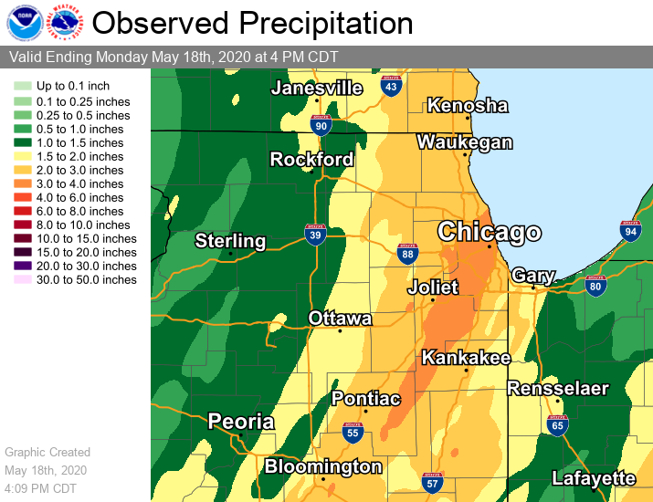
Rain Reports
 |
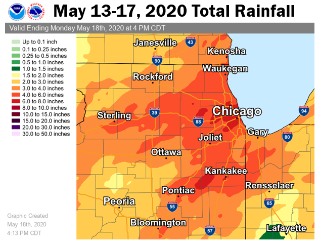 |
| Two day total rainfall from Saturday night to Sunday night, May 16-17, 2020. | Five day total rainfall from May 13-17, 2020, including prior heavy rain event of May 14-15 and this one. |
Public Information Statement
National Weather Service Chicago IL
848 PM CDT Mon May 18 2020 /948 PM EDT Mon May 18 2020/

...PRECIPITATION REPORTS...

The following are 48-hour totals through Monday morning May 18
from volunteer observers.

Location                     Amount    Time/Date
----------------------------------------------------
Oak Lawn                     5.36 in   0700 AM 05/18
Oak Forest 1 NNW             5.15 in   0700 AM 05/18
Bridgeview 1 WNW             5.05 in   0730 AM 05/18
Burbank 1 SSW                5.00 in   0800 AM 05/18
Plainfield 4 SW              4.70 in   0700 AM 05/18
Forest Park 1 ESE            4.59 in   0600 AM 05/18
Midlothian                   4.48 in   0700 AM 05/18
La Grange Park 1 SSW         4.47 in   0700 AM 05/18
Darien 2 SE                  4.42 in   0800 AM 05/18
Chicago - Rogers Park        4.39 in   0800 AM 05/18
Chicago 6.3 NW               4.35 in   0835 AM 05/18
Midway 3 SW                  4.35 in   0700 AM 05/18
Chicago - Albany Park        4.34 in   0700 AM 05/18
Chicago - Lincoln Park       4.29 in   0700 AM 05/18
New Lenox 1 SE               4.29 in   0800 AM 05/18
New Lenox 2 NE               4.29 in   0800 AM 05/18
Lockport 2 SE                4.27 in   0700 AM 05/18
Oak Park 1 NNE               4.23 in   0700 AM 05/18
Riverside                    4.18 in   0600 AM 05/18
Frankfort 4 SW               4.17 in   0800 AM 05/18
Manhattan 3 NW               4.15 in   0700 AM 05/18
Mokena 2 WSW                 4.14 in   0700 AM 05/18
Chicago Ridge                4.07 in   0700 AM 05/18
Hoffman Estates 0.6 ESE      4.06 in   0900 AM 05/18
Naperville 3 SE              4.05 in   0700 AM 05/18
Manhattan 5 ENE              3.97 in   0800 AM 05/18
Homer Glen 3 S               3.92 in   0700 AM 05/18
Alsip 2 NNE                  3.86 in   0645 AM 05/18
Harwood Heights              3.86 in   0700 AM 05/18
Chicago - Hyde Park          3.84 in   0600 AM 05/18
Pontiac 1 S                  3.77 in   0700 AM 05/18
Lakewood Shores 1 SE         3.77 in   0630 AM 05/18
Chicago - West Ridge         3.74 in   0700 AM 05/18
Lake Bluff 2 W               3.73 in   0600 AM 05/18
Manhattan 2 SE               3.71 in   0700 AM 05/18
Evanston 1 E                 3.68 in   0800 AM 05/18
Naperville 5 SSW             3.63 in   0700 AM 05/18
New Lenox 2 SW               3.62 in   0700 AM 05/18
Manhattan 1 E                3.60 in   0830 AM 05/18
Wilmington 0.9 ENE           3.59 in   0800 AM 05/18
Minooka                      3.58 in   0800 AM 05/18
Crown Point                  3.57 in   0645 AM 05/18
Lombard 1 NW                 3.56 in   0800 AM 05/18
Monee 5 W                    3.56 in   0745 AM 05/18
Naperville 4 SSW             3.56 in   0900 AM 05/18
Hillside 1 W                 3.55 in   0700 AM 05/18
Libertyville 1 ESE           3.53 in   0700 AM 05/18
Lombard                      3.52 in   0700 AM 05/18
Plainfield 2 SSE             3.51 in   0700 AM 05/18
Glen Ellyn 1 W               3.49 in   0700 AM 05/18
Mount Prospect 1 SSE         3.47 in   0700 AM 05/18
Morris 2 SSE                 3.46 in   0700 AM 05/18
Elmhurst 1 SE                3.45 in   0700 AM 05/18
1 S Darien                   3.44 in   0800 AM 05/18
Crystal Lawns 2 N            3.43 in   0900 AM 05/18
Clarendon Hills 1 NW         3.42 in   0700 AM 05/18
Buffalo Grove 2 N            3.41 in   0700 AM 05/18
Evanston 1 SSW               3.34 in   0800 AM 05/18
Downers Grove 1 SSW          3.33 in   0800 AM 05/18
Trout Valley                 3.32 in   0700 AM 05/18
New Lenox 1 SSE              3.31 in   0700 AM 05/18
Chicago - Albany Park        3.29 in   0700 AM 05/18
Lincolnshire 2 W             3.28 in   0600 AM 05/18
Buckley                      3.27 in   0800 AM 05/18
Clarendon Hills              3.27 in   0700 AM 05/18
Elk Grove Village 1 ESE      3.24 in   0600 AM 05/18
Lisle 2 SW                   3.23 in   0700 AM 05/18
Park Ridge 1 SSW             3.21 in   0700 AM 05/18
Glen Ellyn 1 SW              3.20 in   0730 AM 05/18
Golf 1 WSW                   3.17 in   0700 AM 05/18
Forest Park 1 ENE            3.17 in   0700 AM 05/18
Lakewood 2 ENE               3.17 in   0700 AM 05/18
Shorewood 2 NE               3.16 in   0700 AM 05/18
Merrillville 2 NNW           3.16 in   0700 AM 05/18
Plainfield 4 NNW             3.15 in   0700 AM 05/18
Cedar Lake 2 S               3.15 in   0800 AM 05/18
Paxton                       3.14 in   0700 AM 05/18
Algonquin 1 NNW              3.13 in   0545 AM 05/18
St. John                     3.13 in   0600 AM 05/18
Huntley                      3.12 in   0700 AM 05/18
Schaumburg 2 E               3.11 in   0700 AM 05/18
Carbon Hill 3 NE             3.11 in   0700 AM 05/18
Campton Hills 3 NNE          3.10 in   0700 AM 05/18
Channahon 3 SE               3.10 in   0700 AM 05/18
Lake Forest 1 NNW            3.09 in   0800 AM 05/18
Riverwoods 1 NE              3.09 in   0700 AM 05/18
Coal City 4 NNW              3.08 in   0700 AM 05/18
Flossmoor 1 SE               3.08 in   0700 AM 05/18
Carbon Hill 3 N              3.08 in   0700 AM 05/18
Highland 0.7 SW              3.08 in   0700 AM 05/18
Carbon Hill 3 NNW            3.07 in   0700 AM 05/18
Elgin 3 W                    3.07 in   0700 AM 05/18
Elmhurst 1 SW                3.05 in   0700 AM 05/18
Northfield                   3.01 in   0740 AM 05/18
Bull Valley 2 WNW            3.01 in   0800 AM 05/18
Morris 1 NW                  2.94 in   0800 AM 05/18
Barrington                   2.93 in   0800 AM 05/18
Naperville                   2.93 in   0600 AM 05/18
Arlington Heights            2.92 in   0600 AM 05/18
Sleepy Hollow 1 W            2.92 in   0700 AM 05/18
Bannockburn                  2.92 in   0700 AM 05/18
Long Lake                    2.90 in   0800 AM 05/18
Mundelein 1 NNE              2.90 in   0800 AM 05/18
Fox Lake Hills               2.90 in   0700 AM 05/18
Evanston                     2.88 in   0700 AM 05/18
Cissna Park 1 S              2.87 in   0700 AM 05/18
Batavia                      2.86 in   0600 AM 05/18
Morris 2 W                   2.86 in   0700 AM 05/18
Peotone                      2.86 in   0700 AM 05/18
Peotone                      2.86 in   0700 AM 05/18
Paxton 2 WSW                 2.85 in   0630 AM 05/18
Dwight                       2.83 in   0700 AM 05/18
Elgin 3 ENE                  2.81 in   0830 AM 05/18
Crescent City 2 N            2.80 in   0600 AM 05/18
Elburn                       2.80 in   0700 AM 05/18
Forest Lake 1 SSW            2.80 in   0700 AM 05/18
McHenry 1 SE                 2.78 in   0915 AM 05/18
Bloomingdale 1 SSE           2.77 in   0700 AM 05/18
Batavia 1 NW                 2.77 in   0530 AM 05/18
Griffith                     2.76 in   0600 AM 05/18
Batavia 1 NNW                2.75 in   0730 AM 05/18
Palatine 1 NNE               2.72 in   0700 AM 05/18
Naperville 1 W               2.72 in   0920 AM 05/18
Lisbon 5 S                   2.72 in   0930 AM 05/18
Batavia 1 NNW                2.72 in   0730 AM 05/18
Batavia 1 NW                 2.72 in   0700 AM 05/18
Elgin                        2.70 in   0700 AM 05/18
Arlington Heights 2 NNW      2.69 in   0700 AM 05/18
Wonder Lake                  2.69 in   0700 AM 05/18
Highwood                     2.67 in   0600 AM 05/18
Arlington Heights 1 W        2.66 in   0700 AM 05/18
Arlington Heights 1 SW       2.63 in   0600 AM 05/18
Lake Station 3 NNW           2.63 in   0725 AM 05/18
Sauk Village 2 SSE           2.62 in   0700 AM 05/18
Dwight 4 NNW                 2.61 in   0700 AM 05/18
St. Anne 3 NNE               2.60 in   0700 AM 05/18
Aurora 2 W                   2.60 in   0700 AM 05/18
Winthrop Harbor              2.60 in   0800 AM 05/18
St. Anne                     2.60 in   0700 AM 05/18
Elgin                        2.59 in   0800 AM 05/18
Elgin 1 SSW                  2.59 in   0800 AM 05/18
St. Charles 1 ENE            2.58 in   0800 AM 05/18
Batavia                      2.57 in   0600 AM 05/18
Sauk Village 3 S             2.57 in   0700 AM 05/18
Ashkum 6 E                   2.56 in   0700 AM 05/18
Griffith                     2.56 in   0700 AM 05/18
Momence 5 ENE                2.56 in   0800 AM 05/18
Aurora 4 ESE                 2.55 in   0700 AM 05/18
Aurora 3 WSW                 2.55 in   0720 AM 05/18
Winthrop Harbor 1 SW         2.55 in   0616 AM 05/18
Flossmoor 1 SSW              2.54 in   0700 AM 05/18
Medinah                      2.54 in   1004 AM 05/18
Zion 1 NW                    2.54 in   0730 AM 05/18
Glen Ellyn 1 SW              2.53 in   0800 AM 05/18
Ottawa - Buffalo Rock SP     2.53 in   0740 AM 05/18
Huntley 2 SW                 2.51 in   0700 AM 05/18
St. John 3 SSE               2.50 in   0700 AM 05/18
Mundelein 4 WSW              2.49 in   0700 AM 05/18
Hammond 1 SSW                2.48 in   0800 AM 05/18
Gibson City 3 WNW            2.47 in   0700 AM 05/18
Oswego 3 NW                  2.47 in   0730 AM 05/18
Sugar Grove 1 NNW            2.46 in   0700 AM 05/18
Plano                        2.45 in   0700 AM 05/18
Lindenhurst 1 NE             2.45 in   0800 AM 05/18
Mundelein 2 WNW              2.45 in   0700 AM 05/18
Greenwood 1 ESE              2.44 in   0700 AM 05/18
Oswego 4 SE                  2.43 in   0700 AM 05/18
Hoffman Estates              2.41 in   0700 AM 05/18
Boulder Hill 1 NNE           2.41 in   0700 AM 05/18
South Elgin 0.9 WSW          2.39 in   0900 AM 05/18
Homewood                     2.36 in   0700 AM 05/18
Chebanse 1 ENE               2.34 in   0400 AM 05/18
Schererville 1 E             2.34 in   0800 AM 05/18
Aurora                       2.32 in   0700 AM 05/18
Chebanse                     2.32 in   0600 AM 05/18
Beecher 4 ENE                2.32 in   0800 AM 05/18
Schererville 1 E             2.31 in   0700 AM 05/18
Lake Zurich 1 N              2.30 in   0600 AM 05/18
Melvin 4 WSW                 2.29 in   0700 AM 05/18
Lindenhurst 1 NNW            2.29 in   0700 AM 05/18
Romeoville 3 NW              2.29 in   0740 AM 05/18
Ogden Dunes                  2.29 in   0530 AM 05/18
Bourbonnais                  2.27 in   0700 AM 05/18
Park Forest 1 WNW            2.25 in   0730 AM 05/18
St. Charles 1 SSW            2.25 in   0730 AM 05/18
Grandwood Park 1 SE          2.22 in   0700 AM 05/18
Park Forest 1 NNE            2.20 in   0700 AM 05/18
Geneva 2 WNW                 2.19 in   0700 AM 05/18
Irwin 3 W                    2.18 in   0700 AM 05/18
Marengo                      2.18 in   0700 AM 05/18
Lansing                      2.18 in   0700 AM 05/18
Oswego 1 SSE                 2.17 in   0700 AM 05/18
Aurora 4 ESE                 2.16 in   0700 AM 05/18
Lake Holiday                 2.16 in   0700 AM 05/18
Woodstock 4 SW               2.15 in   0700 AM 05/18
Hobart 1 ENE                 2.15 in   0600 AM 05/18
Clifton 1 WNW                2.11 in   0600 AM 05/18
Beecher 3 SE                 2.08 in   0700 AM 05/18
Goodenow 2 WSW               2.05 in   0800 AM 05/18
Somonauk 2 NE                2.04 in   0600 AM 05/18
Goodenow 2 NNE               2.03 in   0700 AM 05/18
Sugar Grove 1 NNE            2.01 in   0700 AM 05/18
Marseilles 2 WSW             1.99 in   0820 AM 05/18
Mendota                      1.98 in   0730 AM 05/18
Kaneville 3 NNW              1.94 in   0700 AM 05/18
Morocco                      1.93 in   0600 AM 05/18
Johnsburg 2 SSE              1.91 in   0630 AM 05/18
Streator 1 WSW               1.85 in   0700 AM 05/18
Chatsworth 1 S               1.78 in   0700 AM 05/18
Mount Ayr 5 ENE              1.73 in   0600 AM 05/18
Fair Oaks 4 NE               1.70 in   0700 AM 05/18
Ottawa                       1.68 in   0629 AM 05/18
Nelson 3 NNW                 1.63 in   0800 AM 05/18
Baileys Corner 5 S           1.63 in   0500 AM 05/18
Stoutsburg 1 WNW             1.61 in   0800 AM 05/18
Sycamore                     1.60 in   0700 AM 05/18
Genoa                        1.51 in   0700 AM 05/18
Ottawa 1 N                   1.50 in   0700 AM 05/18
Cortland                     1.49 in   0700 AM 05/18
DeKalb                       1.49 in   0700 AM 05/18
Durand 4 NE                  1.44 in   0900 AM 05/18
DeKalb                       1.42 in   0700 AM 05/18
Rockford 2 ENE               1.39 in   0900 AM 05/18
Rockford                     1.39 in   0700 AM 05/18
Roselawn 3 ENE               1.37 in   0700 AM 05/18
Stoutsburg 1 SW              1.36 in   0700 AM 05/18
Kentland                     1.36 in   0700 AM 05/18
Rensselaer 2 SW              1.36 in   0730 AM 05/18
Rensselaer 4 N               1.34 in   0700 AM 05/18
DeMotte 4 NNW                1.34 in   0800 AM 05/18
Collegeville                 1.33 in   0600 AM 05/18
Rockford 3 WSW               1.31 in   0700 AM 05/18
Kentland 2 SSE               1.31 in   0700 AM 05/18
Machesney Park 1 NW          1.29 in   0500 AM 05/18
Valparaiso                   1.29 in   0924 AM 05/18
Valparaiso 4 SW              1.28 in   0600 AM 05/18
South Beloit 2 SE            1.27 in   0700 AM 05/18
Wheatfield 3 SSE             1.27 in   0814 AM 05/18
Boone Grove 2 WNW            1.25 in   0645 AM 05/18
Timberlane 1 SW              1.24 in   0700 AM 05/18
Malta 3 ESE                  1.24 in   0700 AM 05/18
Capron                       1.23 in   0700 AM 05/18
La Salle                     1.23 in   0700 AM 05/18
Dixon 1 NE                   1.21 in   0700 AM 05/18
Rockford 4 S                 1.21 in   0700 AM 05/18
Valparaiso 2 NW              1.21 in   0700 AM 05/18
DeMotte                      1.20 in   0600 AM 05/18
Baileys Corner 5 W           1.20 in   0700 AM 05/18
Mendota 1 SE                 1.20 in   0600 AM 05/18
DeMotte                      1.18 in   0800 AM 05/18
Remington                    1.16 in   0800 AM 05/18
Valparaiso 2 NNW             1.15 in   0850 AM 05/18
New Milford 3 W              1.14 in   0700 AM 05/18
Roscoe 2 ESE                 1.13 in   0630 AM 05/18
Hebron 1 W                   1.13 in   0929 AM 05/18
Valparaiso 1 N               1.13 in   0700 AM 05/18
Roscoe                       1.13 in   0630 AM 05/18
Boone Grove 4 NNE            1.12 in   0630 AM 05/18
Valparaiso 2 NE              1.08 in   0700 AM 05/18
Valparaiso 2 NNE             1.08 in   0900 AM 05/18
Troy Grove 4 ESE             1.06 in   0800 AM 05/18
Paw Paw 2 S                  1.03 in   0700 AM 05/18
Wheeler 1 SE                 1.01 in   0800 AM 05/18
Rainfall Stats
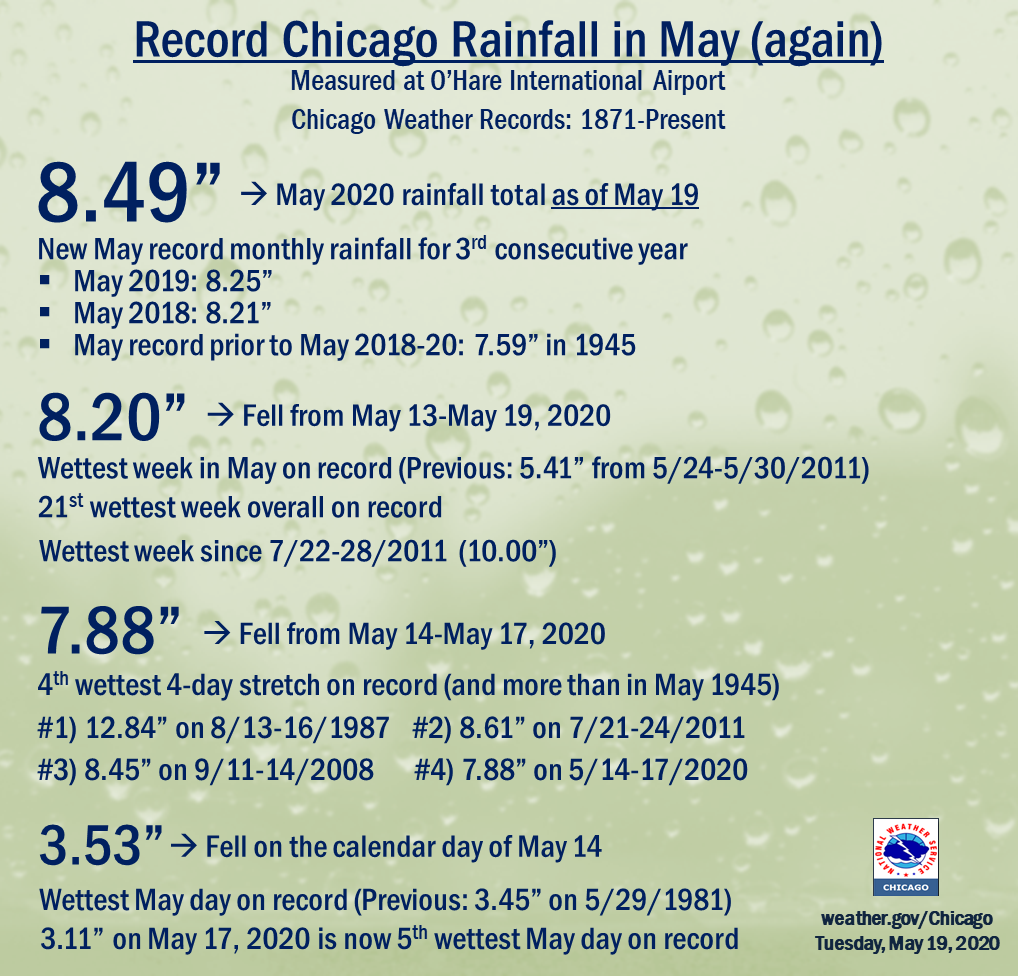 |
| Chicago Record Rainfall Information and Historical Context (as of May 19th) |
During the 4 day period of May 14-17, Chicago recorded 7.88" of rain, making it the 4th wettest 4 day stretch in Chicago recorded weather history dating back to 1871.
The top 4 wettest 4 day stretches in Chicago are:
1) 12.84” (Aug 13-16, 1987)
2) 8.61” (July 21-24, 2011)
3) 8.45” (Sept 11-14, 2008)
4) 7.88” (May 14-17, 2020)
That 7.88" of rainfall is more than has fallen during 1759 of the 1792 months of weather records in Chicago, only 33 months (less than 2%) have had more rain during the entire month than what fell in just that 4 day stretch.
May 2020 is only 0.06" away from breaking the record for wettest May ever in Chicago (as of 7 am on the 18th, so still nearly 2 weeks to potentially add to that total).
The previous wettest May in Chicago was last year with 8.25". Crazily, prior to last year, the wettest May on record as 2018 with 8.21". So in all likelihood Chicago is about to see back to back to back record breaking wet Mays in Chicago!
Finally, prior to the back to back to back record wet Mays, the 7.88" of rain that fell May 14-17th would have been enough to break the record rainfall for the entire month of May prior to 2018, all in just 4 days.
Tornadoes
There were two brief tornadoes that occurred on Sunday, May 17 based on trained spotter reports. One was in northwest Kendall County, southeast of the town of Sandwich. The other was near the Grundy and Will County border just west of Braidwood and just west of I-55.
Additional Info
 |
 |
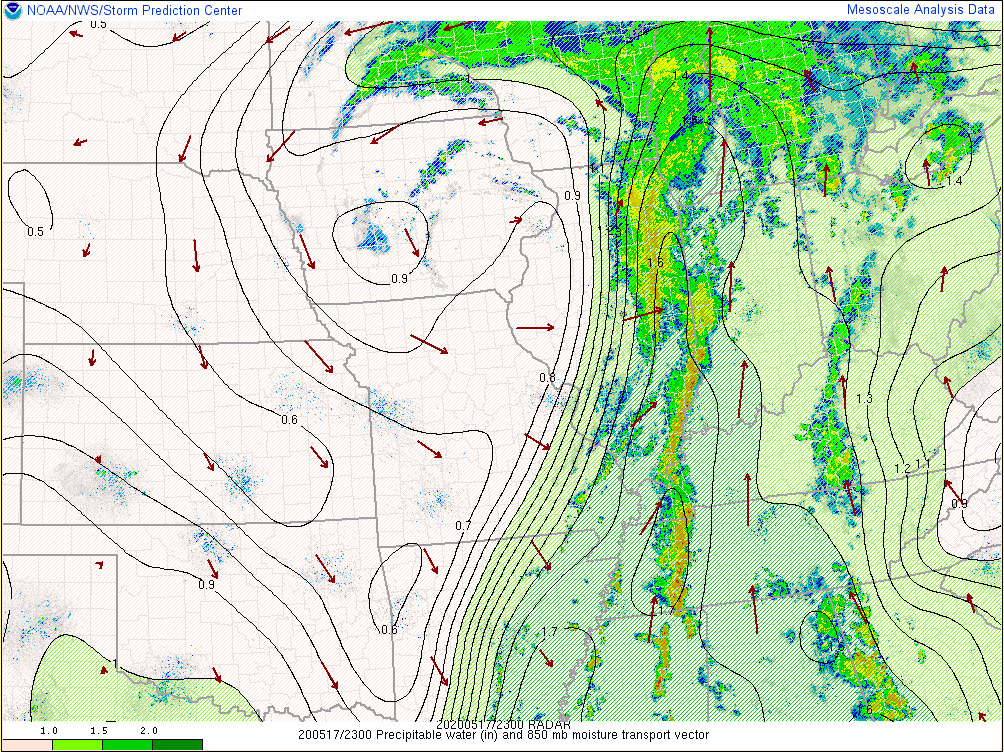 |
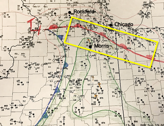
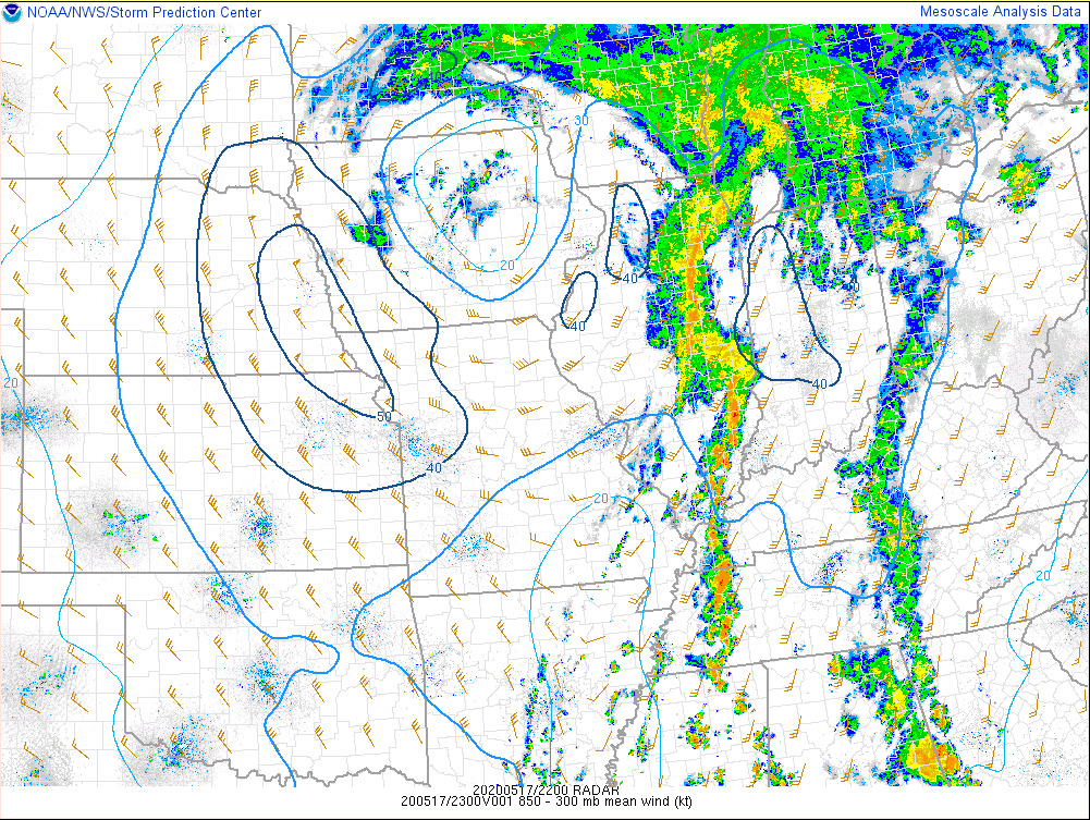
| 2 p.m. May 17 hand analyzed surface map depicting the warm frontal zone over the area and high moisture being advected into the region. Temperatures near 70 also supported low-level instability, not much, but enough for some rotating updrafts. Note the southeast winds near the warm front and south of it for a ways resulted in veering low-level profiles to support the threat of brief tornadoes. | 6 p.m. May 17 850-300mb winds | 6 p.m. May 17 precipitable waters |
 |
 |
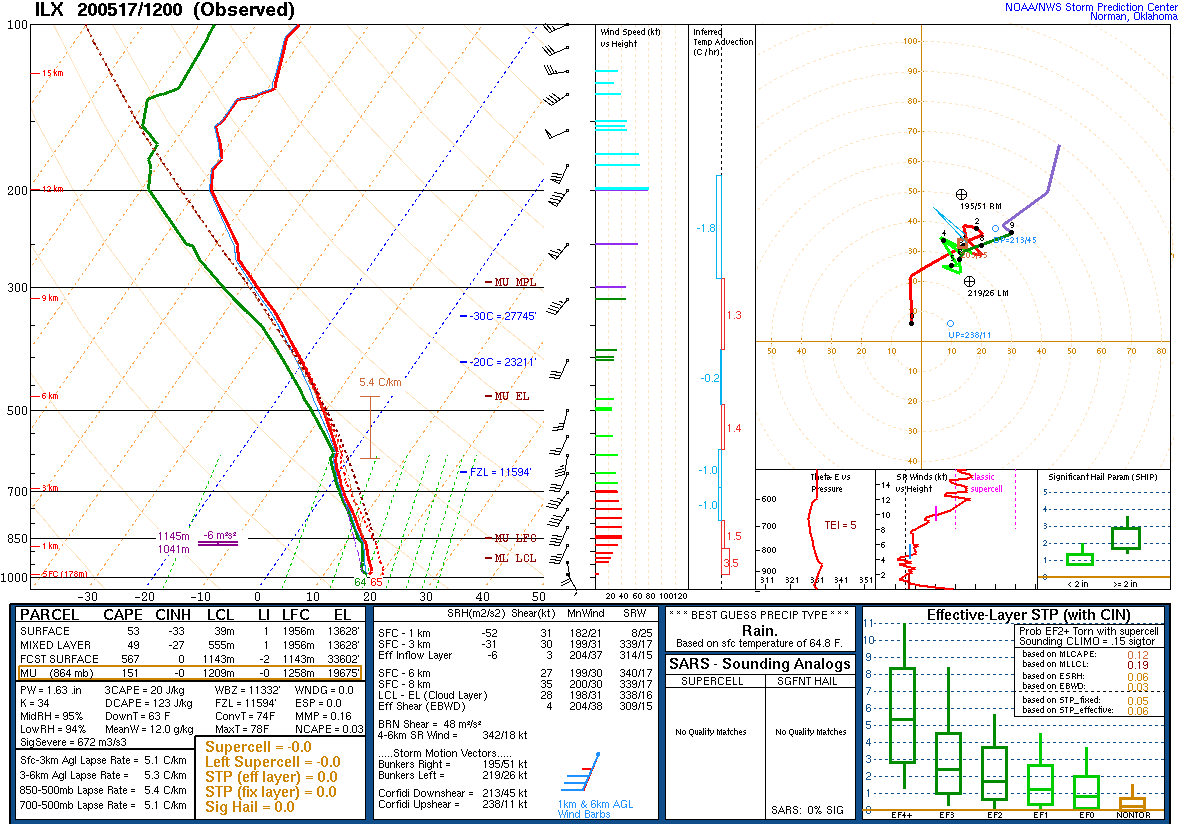 |
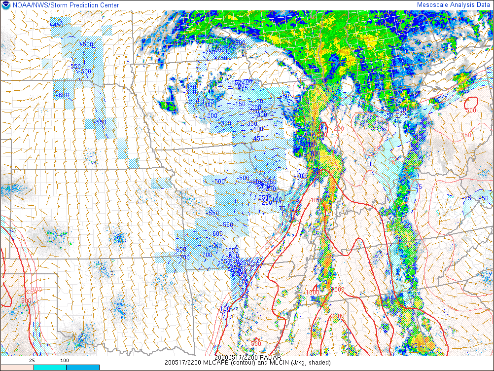
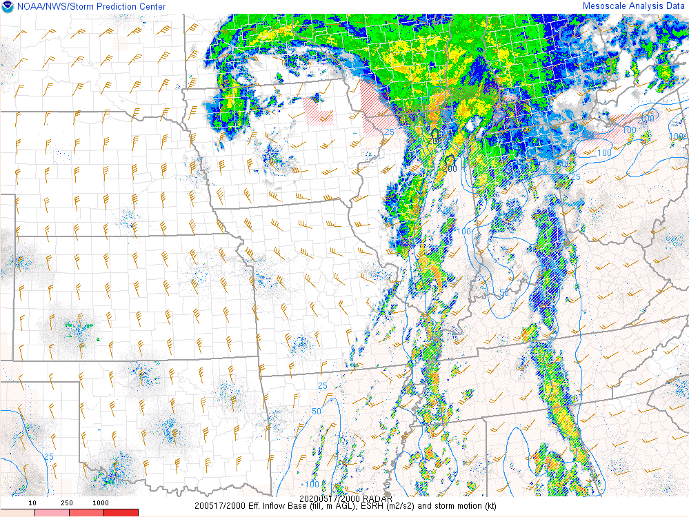
| 6 p.m. May 17 mixed layer CAPE. | 6 p.m. May 17 effective helicity. | 7 a.m. May 17 NWS Central Illinois weather balloon data (sounding). |
 |
Media use of NWS Web News Stories is encouraged! Please acknowledge the NWS as the source of any news information accessed from this site. Additional recaps can be found on the NWS Chicago Past Events Page |
|

