Life-threatening and locally catastrophic flash and urban flooding is expected across portions of south-central Texas through early Friday, with significant river flooding and rapid rises on small streams, arroyos, and typically dry washes expected. A significant heat wave continues for the Rockies, Northern Plains, and Great Lakes into the Mid-Atlantic, peaking in intensity through midweek. Read More >
Fast Facts | Snowfall Map | Science | Snowfall Reports
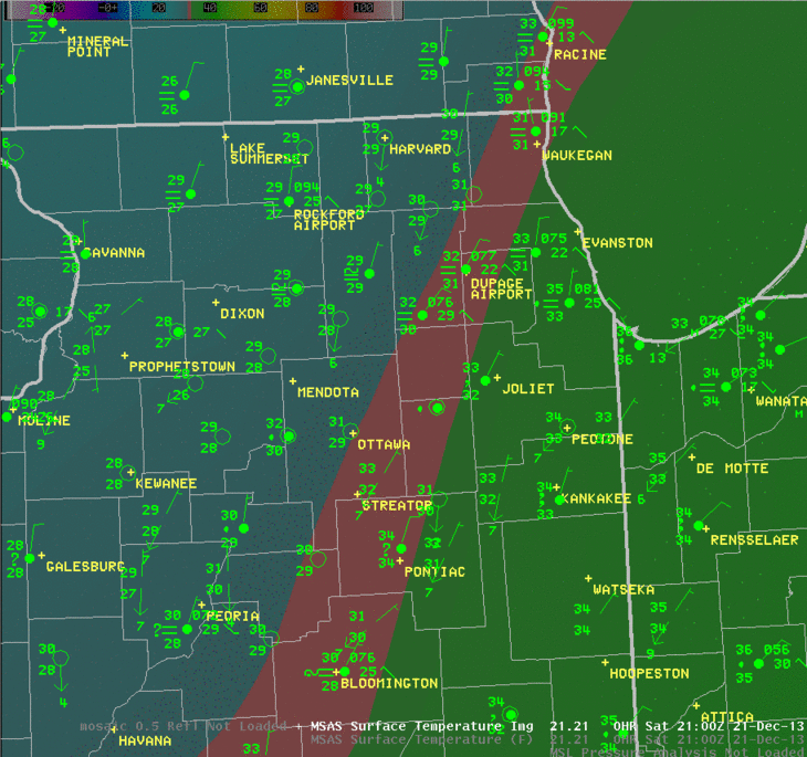
The first official weekend of winter was greeted with an extended mess of mixed precipitation, primarily rain, freezing rain, and snow. The largest snowfall totals were well to the west and northwest of the area covered by NWS Chicago, but a large portion of northern and northwest Illinois received a prolonged period of light freezing rain during the beginning of the event on Friday.
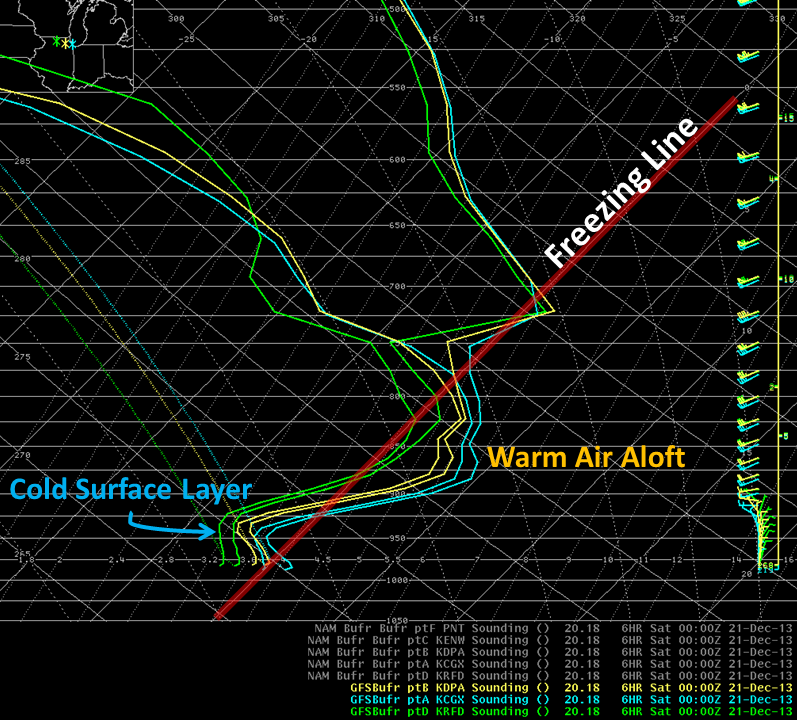
The image below, valid Friday evening at 6 PM, shows the vertical temperature profiles near Rockford (green), Wheaton (yellow), and downtown Chicago (blue). From this image it is apparent why areas around Rockford were receiving freezing rain, while areas to the southeast were primarily reporting rain on Friday. All three locations had a deep layer of warm (above-freezing) air above the surface, but at Rockford this layer was not quite so warm, and at the surface the temperature was below freezing. In contrast, the forecast sounding for the Chicago area was considerably warmer both aloft and at the surface. In areas between these two locations, the freezing line at the surface was constantly evolving on Friday, bring periods of both rain and freezing rain.
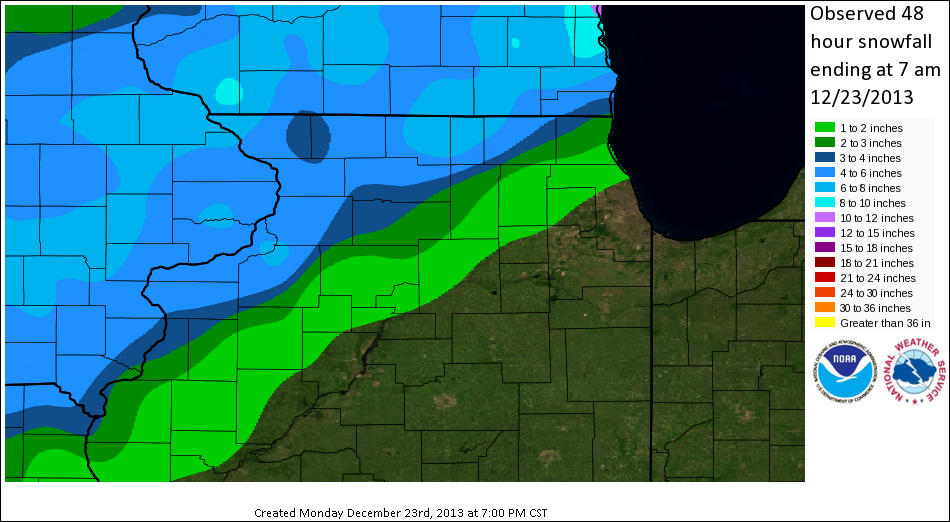
After the rain and freezing rain/drizzle ended late Friday, a new round of precipitation moved into the area on Saturday. Again the vertical temperature profile and the location of the freezing line at the surface were both key in determining which areas received rain and which received snow or freezing rain. The image below shows an animation of the approximate location of the 32 degree freezing line at the surface from 3 PM Saturday through noon on Sunday. Note the evolving precipitation trends at various locations as they move from the cool side to the "warm" side of that boundary, and also note how this boundary moves relative to the wind directions.
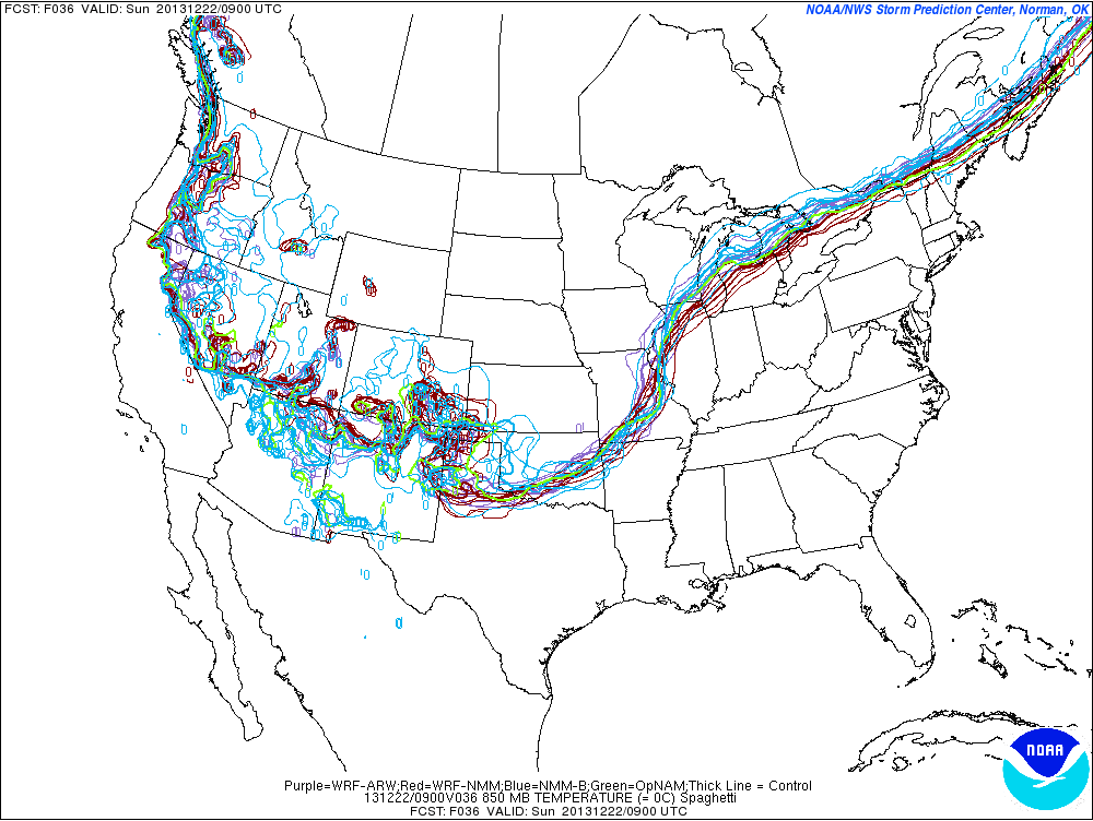
Clearly the location of the freezing line is critical both at the surface and aloft. The challenge during winter events like this, when the freezing line runs right through the forecast area, is knowing in advance where it will set up. Forecasters utilize as many tools as they can, including computer forecast models, when trying to make a decision about watches, warnings, and advisories, but even sophisticated computer models have trouble trying to pin down the exact location of such features. As an example, the image below shows the various locations that many different models had for the freezing line at 850 MB, or about a mile up in the sky. The location of the freezing line aloft provides a very general idea of which areas will receive snow and which areas will see liquid or mixed precipitation. This image is a forecast from Friday afternoon valid at 3 AM Sunday, and there is considerable variation in the location of this important feature. Areas of Wisconsin and Iowa well to the north of this line can be confident of receiving mostly snow during this time, while areas well to the south can be confident in receiving nearly all rain. Areas like northern Illinois right under the spaghetti section could receive either rain, snow, freezing rain, or a mix of all three. This presents a considerable forecast challenge.
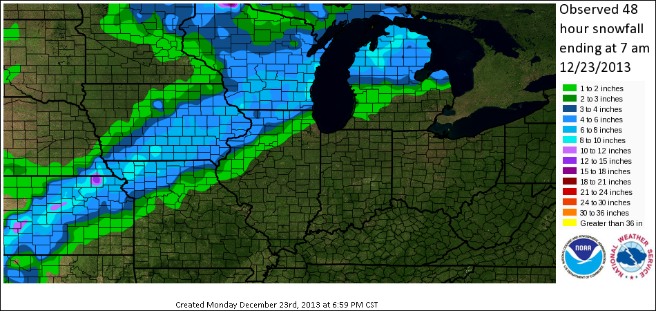
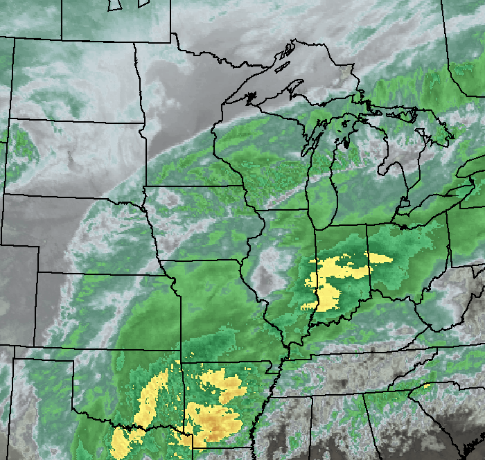
This image below is a loop of infrared satellite imagery from a regional perspective, looking at the system as it developed and pushed over the region Saturday into Sunday morning.
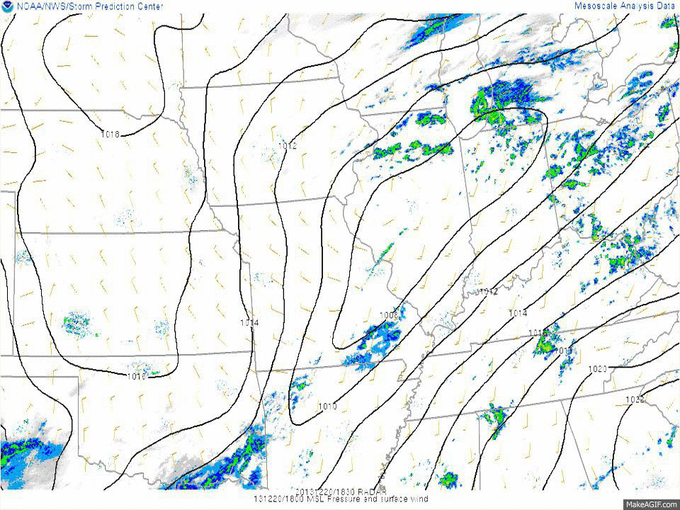
This final image below is a loop of mean sea level pressure and regional radar, valid every three hours from Friday afternoon through Sunday morning. The event begins Friday with patchy freezing rain and drizzle, then after a few hours break, continues Saturday into Sunday morning with rain, snow, and more freezing rain and freezing drizzle.
|
Local List |
|
|
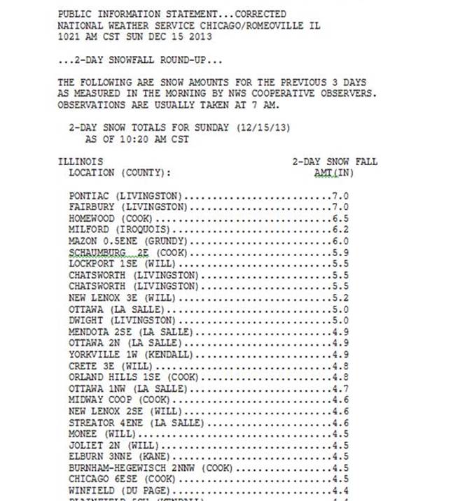
Storm Totals From Volunteer NWS Cooperative, CoCoRaHS and Official NWS Snowfall Observations
PUBLIC INFORMATION STATEMENT
NATIONAL WEATHER SERVICE CHICAGO/ROMEOVILLE IL
1038 AM CST MON DEC 23 2013

...2-DAY SNOWFALL ROUND-UP...

THE FOLLOWING ARE SNOW AMOUNTS FOR THE PREVIOUS 2 DAYS
AS MEASURED IN THE MORNING BY NWS COOPERATIVE OBSERVERS...
COCORAHS OBSERVERS AND CHICAGO...ROCKFORD AREA SNOW TEAMS.
OBSERVATIONS ARE USUALLY TAKEN AT 7 AM.

  2-DAY SNOW TOTALS FOR MONDAY (12/23/13)
     AS OF 10:38 AM CST

ILLINOIS                                 2-DAY SNOW FALL
  LOCATION (COUNTY):                         AMT(IN) REPORTS

  HARVARD (MCHENRY).............................7.0     (2)
  ROSCOE 2SE (WINNEBAGO)........................6.6     (2)
  ROSCOE 2ESE (WINNEBAGO).......................6.6     (2)
  ROCKTON 1ESE (WINNEBAGO)......................6.3     (2)
  BELVIDERE (BOONE).............................5.6     (2)
  BYRON 3N (OGLE)...............................5.4     (2)
  HEBRON (MCHENRY)..............................5.2     (2)
  ROCKFORD (WINNEBAGO)..........................5.2     (2)
  CAPRON (BOONE)................................4.9     (2)
  POLO (OGLE)...................................4.7     (2)
  MOUNT MORRIS (OGLE)...........................4.6     (2)
  ANTIOCH 4W (LAKE).............................4.2     (2)
  SPRING GROVE 2N (MCHENRY).....................4.2     (2)
  WOODSTOCK 5NW (MCHENRY).......................3.6     (2)
  WONDER LAKE 1WNW (MCHENRY)....................3.5     (2)
  DIXON 2SW (LEE)...............................3.5     (2)
  FOX LAKE HILLS 1NW (LAKE).....................3.4     (2)
  BULL VALLEY 2WNW (MCHENRY)....................3.3     (2)
  ROCHELLE (OGLE)...............................3.0     (2)
  ASHTON (LEE)..................................3.0     (2)
  LAKE VILLA 1SSW (LAKE)........................2.9     (2)
  AMBOY (LEE)...................................2.7     (2)
  FOX LAKE 2SE (LAKE)...........................2.4     (2)
  BEACH PARK 1W (LAKE)..........................2.4     (2)
  GURNEE 2NE (LAKE).............................2.3     (2)
  WAUKEGAN 2N (LAKE)............................2.1     (2)
  GENOA (DE KALB)...............................2.1     (2)
  GURNEE 2W (LAKE)..............................2.0     (2)
  MUNDELEIN (LAKE)..............................1.8     (2)
  MALTA (DE KALB)...............................1.7     (2)
  DE KALB (DE KALB).............................1.6     (2)
  PAW PAW (LEE).................................1.5     (2)
  MENDOTA 2SE (LA SALLE)........................1.5     (2)
  ELGIN 2W (KANE)...............................1.5     (2)
  BARRINGTON (LAKE).............................1.5     (2)
  DE KALB (DE KALB).............................1.4     (2)
  ELGIN 1S (KANE)...............................1.3     (2)
  CORTLAND (DE KALB)............................1.3     (2)
  ELGIN (KANE)..................................1.3     (2)
  STEWARD (LEE).................................1.2     (2)
  LAKE BLUFF 1W (LAKE)..........................1.1     (2)
  MENDOTA (LA SALLE)............................1.0     (2)
  ALGONQUIN 1N (MCHENRY)........................1.0     (2)
  INVERNESS 2S (COOK)...........................1.0     (2)
  PALATINE 1E (COOK)............................1.0     (2)
  ELGIN (KANE)..................................1.0     (2)
  ELBURN (KANE).................................1.0     (2)
  BUFFALO GROVE 2N (LAKE).......................0.8     (2)
  BATAVIA 2WNW (KANE)...........................0.8     (2)
  BATAVIA 1WNW (KANE)...........................0.7     (2)
  BARTLETT 1SSE (DU PAGE).......................0.7     (2)
  ELK GROVE VILLAGE 1ESE (COOK).................0.7     (2)
  HOFFMAN ESTATES 5W (COOK).....................0.7     (2)
  BOTANIC GARDENS (COOK)........................0.7     (2)
  OAK BROOK (DU PAGE)...........................0.6     (2)
  DOWNERS GROVE (DU PAGE).......................0.6     (2)
  WINFIELD (DU PAGE)............................0.6     (2)
  LINCOLNSHIRE 1N (LAKE)........................0.6     (2)
  NAPERVILLE 1NW (DU PAGE)......................0.6     (2)
  OTTAWA (LA SALLE).............................0.5     (2)
  LA SALLE (LA SALLE)...........................0.5     (2)
  MARSEILLES 6WNW (LA SALLE)....................0.5     (2)
  SHERIDAN 3SSE (LA SALLE)......................0.5     (2)
  NORTH AURORA 2NE (KANE).......................0.5     (2)
  PLAINFIELD 5SW (KENDALL)......................0.5     (2)
  YORKVILLE 1NE (KENDALL).......................0.5     (2)
  ELK GROVE VILLAGE 2WSW (COOK).................0.5     (2)
  SCHAUMBURG 3WSW (COOK)........................0.5     (2)
  BATAVIA (KANE)................................0.5     (2)
  AURORA (KANE).................................0.5     (2)
  YORKVILLE 2SE (KENDALL).......................0.4     (2)
  SUGAR GROVE 1NE (KANE)........................0.4     (2)
  LA GRANGE PARK 1SSW (COOK)....................0.4     (2)
  PLAINFIELD (WILL).............................0.3     (2)
  JOLIET 2N (WILL)..............................0.3     (2)
  LISLE 1SE (DU PAGE)...........................0.3     (2)
  WESTMONT 1SSE (DU PAGE).......................0.3     (2)
  LINCOLNWOOD 2E (COOK).........................0.3     (2)
  PARK RIDGE (COOK).............................0.3     (2)
  ROMEOVILLE (WILL).............................0.3     (2)
  YORKVILLE 1W (KENDALL)........................0.3     (2)
  HOMER GLEN 4WNW (WILL)........................0.2     (2)
  MARSEILLES 3NW (LA SALLE).....................0.2     (2)
  DOWNERS GROVE 2SE (DU PAGE)...................0.2     (2)
  HARWOOD HEIGHTS 2NNE (COOK)...................0.2     (2)
  LISLE MORTON ARB (DU PAGE)....................0.1     (2)
  OHARE (COOK)..................................0.1     (2)
  MIDWAY COOP (COOK)............................0.1     (2)
  NEW LENOX 3E (WILL)...........................0.1     (2)
  CARBON HILL 3.1N (GRUNDY).....................0.1     (2)
  BURR RIDGE 2SW (DU PAGE)......................0.1     (2)
  BOLINGBROOK 3NE (DU PAGE).....................0.1     (2)
  COAL CITY 4NNW (GRUNDY).......................0.1     (2)

INDIANA                                    2-DAY SNOW FALL
  LOCATION (COUNTY):                         AMT(IN) REPORTS

  PORTER 1S (PORTER)............................0.3     (2)
  VALPARAISO 5NNE (PORTER)......................0.2     (2)
  VALPARAISO 1SE (PORTER).......................0.1     (2)
  RENSSELAER (JASPER)...........................0.0     (2)
  REMINGTON (JASPER)............................0.0     (2)
  LAKE VILLAGE (NEWTON).........................0.0     (2)
  VALPARAISO 1NNW (PORTER)......................0.0     (2)
  HEBRON 1NW (PORTER)...........................0.0     (2)


$$