Overview
Fast Facts
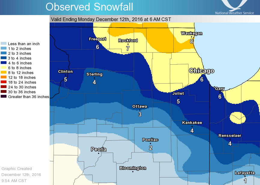
Event Snow Totals
PUBLIC INFORMATION STATEMENT
NATIONAL WEATHER SERVICE CHICAGO/ROMEOVILLE IL
1122 AM CST MON DEC 12 2016


...2-DAY SNOWFALL ROUND-UP...

THE FOLLOWING ARE SNOW AMOUNTS FOR THE PREVIOUS 2 DAYS
AS MEASURED IN THE MORNING BY NWS COOPERATIVE OBSERVERS
AND COCORAHS OBSERVERS. OBSERVATIONS ARE USUALLY
TAKEN AT 7 AM.

  2-DAY SNOW TOTALS FOR MONDAY (12/12/16)
     AS OF 11:22 AM CST

ILLINOIS                                 2-DAY SNOW FALL
  LOCATION (COUNTY):                         AMT(IN) REPORTS

  HARVARD 3SSE (MCHENRY).......................11.7     (2)
  BULL VALLEY 2WNW (MCHENRY)...................10.8     (2)
  HARVARD (MCHENRY).............................9.5     (2)
  RIVERWOODS (LAKE).............................9.3     (2)
  LAKE ZURICH (LAKE)............................9.1     (2)
  HIGHWOOD 1S (LAKE)............................9.0     (2)
  GENOA (DE KALB)...............................8.8     (2)
  WOODSTOCK 5NW (MCHENRY).......................8.7     (2)
  WOODSTOCK 4SW (MCHENRY).......................8.5     (2)
  WONDER LAKE 1WNW (MCHENRY)....................8.1     (2)
  SCHAUMBURG 2E (COOK)..........................8.1     (2)
  DOWNERS GROVE 0.4NNE (DU PAGE)...............11.7     (3)
  ST. CHARLES (KANE)............................8.0     (2)
  WAUKEGAN 2N (LAKE)............................7.9     (2)
  ELK GROVE VILLAGE 1ESE (COOK).................7.9     (2)
  OHARE (COOK)..................................7.8     (2)
  LAKE VILLA 1SSW (LAKE)........................7.8     (2)
  BEACH PARK 1W (LAKE)..........................7.8     (2)
  ELGIN 2W (KANE)...............................7.8     (2)
  HOFFMAN ESTATES 5W (COOK).....................7.8     (2)
  ROSCOE 2SE (WINNEBAGO)........................7.7     (2)
  ROSCOE 2ESE (WINNEBAGO).......................7.7     (2)
  LAKE VILLA 2WSW (LAKE)........................7.7     (2)
  BARRINGTON (LAKE).............................7.7     (2)
  FOX LAKE 2SE (LAKE)...........................7.7     (2)
  ELK GROVE VILLAGE 2WSW (COOK).................7.7     (2)
  PARK FOREST (COOK)............................7.5     (2)
  BUFFALO GROVE 2N (LAKE).......................7.5     (2)
  LINCOLNSHIRE 1N (LAKE)........................7.5     (2)
  GENEVA 4WSW (KANE)............................7.5     (2)
  BOTANIC GARDENS (COOK)........................7.5     (2)
  WILLOW SPRINGS (COOK).........................7.4     (2)
  MUNDELEIN 2WNW (LAKE).........................7.4     (2)
  GENEVA 1SSW (KANE)............................7.3     (2)
  MUNDELEIN (LAKE)..............................7.2     (2)
  MIDWAY COOP (COOK)............................7.0     (2)
  ROCKFORD 1NW (WINNEBAGO)......................7.0     (2)
  BATAVIA 1WSW (KANE)...........................7.0     (2)
  ROSELLE 1ESE (DU PAGE)........................7.0     (2)
  PARK RIDGE 1WNW (COOK)........................7.0     (2)
  BATAVIA 2WNW (KANE)...........................6.9     (2)
  MCHENRY (MCHENRY).............................6.7     (2)
  PALATINE 1E (COOK)............................6.7     (2)
  ELMHURST 1ESE (DU PAGE).......................6.7     (2)
  ROCKFORD 2ENE (WINNEBAGO).....................6.5     (2)
  NAPERVILLE 1NW (DU PAGE)......................6.5     (2)
  OAK PARK 2S (COOK)............................6.5     (2)
  PARK RIDGE (COOK).............................6.4     (2)
  ROCKFORD (WINNEBAGO)..........................6.3     (2)
  LISLE 1SE (DU PAGE)...........................6.3     (2)
  LINCOLNWOOD 2E (COOK).........................6.2     (2)
  MONEE (WILL)..................................6.1     (2)
  CRETE 3E (WILL)...............................6.1     (2)
  BATAVIA (KANE)................................6.1     (2)
  BYRON 3N (OGLE)...............................6.0     (2)
  NORTH AURORA 2NE (KANE).......................6.0     (2)
  ELBURN (KANE).................................6.0     (2)
  OAK LAWN 2WNW (COOK)..........................6.0     (2)
  ELBURN (KANE).................................6.0     (2)
  AMBOY (LEE)...................................6.0     (2)
  SUGAR GROVE 1NE (KANE)........................5.9     (2)
  LISLE (DU PAGE)...............................5.9     (2)
  PEOTONE (WILL)................................5.8     (2)
  LA GRANGE PARK 1SSW (COOK)....................5.8     (2)
  ROMEOVILLE (WILL).............................5.6     (2)
  DE KALB (DE KALB).............................5.6     (2)
  ROGERS PARK 2SW (COOK)........................5.6     (2)
  NEW LENOX 2SE (WILL)..........................5.5     (2)
  ST. CHARLES 6NW (KANE)........................5.5     (2)
  ELGIN 1S (KANE)...............................5.5     (2)
  NAPERVILLE 2SE (DU PAGE)......................5.5     (2)
  SOMONAUK 2NE (DE KALB)........................5.5     (2)
  LINCOLNWOOD 3E (COOK).........................5.5     (2)
  CHICAGO RIDGE (COOK)..........................5.5     (2)
  CHICAGO 6ESE (COOK)...........................5.5     (2)
  ELGIN (KANE)..................................5.5     (2)
  CAPRON (BOONE)................................5.4     (2)
  BURR RIDGE 2SW (DU PAGE)......................5.3     (2)
  LANSING (COOK)................................5.2     (2)
  PARK FOREST 1SW (COOK)........................5.2     (2)
  HOMER GLEN 1ENE (WILL)........................5.1     (2)
  BOLINGBROOK 3NE (DU PAGE).....................5.1     (2)
  JOLIET LOCK/DAM (WILL)........................5.0     (2)
  DE KALB (DE KALB).............................5.0     (2)
  MANHATTAN (WILL)..............................4.9     (2)
  MANHATTAN 5ENE (WILL).........................4.9     (2)
  PLAINFIELD 5SW (KENDALL)......................4.9     (2)
  CORTLAND (DE KALB)............................4.9     (2)
  PALOS PARK 1SW (COOK).........................4.9     (2)
  WORTH (COOK)..................................4.9     (2)
  YORKVILLE 2SE (KENDALL).......................4.8     (2)
  OAK LAWN (COOK)...............................4.7     (2)
  NAPERVILLE 4SSW (WILL)........................4.7     (2)
  LISLE MORTON ARB (DU PAGE)....................4.6     (2)
  NEW LENOX 3E (WILL)...........................4.5     (2)
  LOCKPORT 1SE (WILL)...........................4.5     (2)
  GURNEE 2W (LAKE)..............................4.5     (1)
  LAKE FOREST 2NNE (LAKE).......................4.5     (1)
  PLAINFIELD (WILL).............................4.4     (2)
  MOKENA 1W (WILL)..............................4.4     (2)
  HOMEWOOD (COOK)...............................4.4     (2)
  WILMINGTON 3SE (WILL).........................4.3     (2)
  JOLIET 2N (WILL)..............................4.2     (2)
  NEW LENOX 4SE (WILL)..........................4.2     (2)
  MONTGOMERY 1SSE (KENDALL).....................4.0     (2)
  EARLVILLE 3S (LA SALLE).......................4.0     (2)
  DIXON (LEE)...................................4.0     (2)
  STEWARD (LEE).................................3.9     (2)
  ASHTON (LEE)..................................3.9     (2)
  MANHATTAN 2SE (WILL)..........................3.8     (2)
  OTTAWA 2N (LA SALLE)..........................3.8     (2)
  PLAINFIELD 2SSE (WILL)........................3.6     (2)
  OTTAWA 1NW (LA SALLE).........................3.5     (2)
  DIXON 2SW (LEE)...............................3.5     (2)
  MOMENCE (KANKAKEE)............................3.2     (2)
  LA SALLE (LA SALLE)...........................3.2     (2)
  CARBON HILL 3.1N (GRUNDY).....................3.2     (2)
  COAL CITY 4NNW (GRUNDY).......................3.2     (2)
  ST ANNE (KANKAKEE)............................3.0     (2)
  MAZON 0.5ENE (GRUNDY).........................3.0     (2)
  BOURBONNAIS (KANKAKEE)........................3.0     (2)
  MORRIS 6ESE (GRUNDY)..........................2.9     (2)
  OTTAWA (LA SALLE).............................2.7     (2)
  MINOOKA (GRUNDY)..............................2.6     (2)
  PAW PAW (LEE).................................2.5     (2)
  MORRIS (GRUNDY)...............................2.5     (2)
  BONFIELD 4WSW (KANKAKEE)......................2.5     (2)
  ASHKUM 5.6E (IROQUOIS)........................2.4     (2)
  STREATOR 4ENE (LA SALLE)......................2.0     (2)
  WATSEKA 6.9WNW (IROQUOIS).....................2.0     (2)
  MARSEILLES (LA SALLE).........................1.9     (2)
  CHATSWORTH (LIVINGSTON).......................1.0     (2)
  DWIGHT (LIVINGSTON)...........................1.0     (2)
  CHATSWORTH (LIVINGSTON).......................1.0     (2)

INDIANA                                    2-DAY SNOW FALL
  LOCATION (COUNTY):                         AMT(IN) REPORTS

  CHESTERTON 4E (PORTER)........................7.5     (2)
  CROWN POINT (LAKE)............................7.2     (2)
  (KB9F)VALPARAISO 4S (PORTER)..................7.0     (2)
  (W9MAL)MERRILLVILLE 2NNW (LAKE)...............7.0     (2)
  VALPARAISO 6WSW (PORTER)......................6.6     (2)
  LAKES OF THE FOUR SEASONS 2NNE (PORTER).......6.6     (2)
  CROWN POINT 1N (LAKE).........................6.6     (2)
  DE MOTTE 1NNW (JASPER)........................6.5     (2)
  PORTAGE 3E (PORTER)...........................6.0     (2)
  HEBRON 4NE (PORTER)...........................6.0     (2)
  PORTER 1S (PORTER)............................5.9     (2)
  VALPARAISO 6SSW (PORTER)......................5.5     (2)
  DE MOTTE 4SW (JASPER).........................5.5     (2)
  VALPARAISO 1SE (PORTER).......................5.3     (2)
  REMINGTON (JASPER)............................5.2     (2)
  VALPARAISO 4SW (PORTER).......................5.0     (2)
  DE MOTTE 6S (JASPER)..........................4.5     (2)
  DYER 1WNW (LAKE)..............................4.0     (2)
  REMINGTON (JASPER)............................4.0     (2)
  RENSSELAER (JASPER)...........................3.1     (2)
  MOROCCO (NEWTON)..............................3.0     (2)
  CROWN POINT 2WSW (LAKE).......................3.0     (2)
  MOUNT AYR 2NNE (NEWTON).......................2.6     (2)

$$
Storm Reports
539

NWUS53 KLOT 021443

LSRLOT


Preliminary Local Storm Report

National Weather Service Chicago IL

943 AM CDT Sun Aug 2 2026


..TIME...   ...EVENT...      ...CITY LOCATION...     ...LAT.LON...

..DATE...   ....MAG....      ..COUNTY LOCATION..ST.. ...SOURCE....

            ..REMARKS..


0700 AM     Rain             2 SSW Frankfort Square  41.49N 87.81W

08/02/2026  M4.94 Inch       Will               IL   Cocorahs


            Cocorahs station IL-WL-165 Frankfort 1 ESE.


0700 AM     Rain             1 SE Flossmoor          41.53N 87.66W

08/02/2026  M4.78 Inch       Cook               IL   Cocorahs


            Cocorahs station IL-CK-229 Flossmoor 1 SE.


0830 AM     Rain             2 WNW Montgomery        41.74N 88.38W

08/02/2026  M4.46 Inch       Kane               IL   Mesonet


            Mesonet station BBMI2 Montgomery -

            Blackberry Cr.


0700 AM     Rain             2 N Hammond             41.61N 87.49W

08/02/2026  M4.27 Inch       Lake               IN   Cocorahs


            Cocorahs station IN-LK-89 Hammond 2 N.


0700 AM     Rain             2 NW Rockdale           41.53N 88.14W

08/02/2026  M4.18 Inch       Will               IL   Cocorahs


            Cocorahs station IL-WL-175 Rockdale 1 NW.


0700 AM     Rain             3 N Carbon Hill         41.34N 88.30W

08/02/2026  M4.18 Inch       Grundy             IL   Cocorahs


            Cocorahs station IL-GY-1 Carbon Hill 3 N.


0700 AM     Rain             3 N Carbon Hill         41.34N 88.30W

08/02/2026  M4.18 Inch       Grundy             IL   CO-OP Observer


            CO-OP Observer station CTYI2 Coal City 4

            NNW.


0500 AM     Rain             1 N Park Forest         41.50N 87.68W

08/02/2026  M3.68 Inch       Cook               IL   CO-OP Observer


            CO-OP Observer station PKFI2 Park Forest.


0600 AM     Rain             1 W Joliet              41.53N 88.11W

08/02/2026  M3.66 Inch       Will               IL   Cocorahs


            Cocorahs station IL-WL-174 Joliet 0.8 E.


0700 AM     Rain             Burr Ridge              41.75N 87.91W

08/02/2026  M3.63 Inch       Cook               IL   Cocorahs


            Cocorahs station IL-CK-394 Burr Ridge.


0800 AM     Rain             2 S Woodridge           41.73N 88.05W

08/02/2026  M3.62 Inch       DuPage             IL   Cocorahs


            Cocorahs station IL-DP-174 Bolingbrook 2.6

            NE.


0700 AM     Rain             3 NNW Carbon Hill       41.33N 88.31W

08/02/2026  M3.61 Inch       Grundy             IL   Cocorahs


            Cocorahs station IL-GY-16 Carbon Hill 3 NNW.


0700 AM     Rain             NWS Chicago-Romeoville  41.60N 88.09W

08/02/2026  M3.49 Inch       Will               IL   CO-OP Observer


            CO-OP Observer station LOTI2 Romeoville -

            NWS Chicago.


0700 AM     Rain             1 NNE Oak Park          41.91N 87.78W

08/02/2026  M3.49 Inch       Cook               IL   Cocorahs


            Cocorahs station IL-CK-74 Oak Park 1 NNE.


0700 AM     Rain             3 ESE Manhattan         41.41N 87.93W

08/02/2026  M3.38 Inch       Will               IL   Cocorahs


            Cocorahs station IL-WL-198 Manhattan 3.5

            ESE.


0700 AM     Rain             3 NNW Lake Station      41.62N 87.25W

08/02/2026  M3.37 Inch       Lake               IN   Cocorahs


            Cocorahs station IN-LK-63 Gary 5 ENE.


0700 AM     Rain             4 ESE Aurora            41.73N 88.24W

08/02/2026  M3.36 Inch       DuPage             IL   Cocorahs


            Cocorahs station IL-DP-101 Aurora 4 ESE.


0800 AM     Rain             Minooka                 41.45N 88.25W

08/02/2026  M3.34 Inch       Grundy             IL   Cocorahs


            Cocorahs station IL-GY-10 Minooka.


0700 AM     Rain             1 S Woodridge           41.74N 88.05W

08/02/2026  M3.34 Inch       DuPage             IL   Cocorahs


            Cocorahs station IL-DP-198 Woodridge 0.3 SW.


0600 AM     Rain             1 SSE Boulder Hill      41.70N 88.33W

08/02/2026  M3.32 Inch       Kendall            IL   Cocorahs


            Cocorahs station IL-KD-136 Oswego.


0800 AM     Rain             2 WSW Goodenow          41.38N 87.68W

08/02/2026  M3.28 Inch       Will               IL   Cocorahs


            Cocorahs station IL-WL-149 Monee 5 SE.


0700 AM     Rain             1 SSW Yorkville         41.63N 88.46W

08/02/2026  M3.19 Inch       Kendall            IL   Cocorahs


            Cocorahs station IL-KD-110 Yorkville 0.9

            SSW.


0700 AM     Rain             1 NW Clarendon Hills    41.80N 87.97W

08/02/2026  M3.19 Inch       DuPage             IL   Cocorahs


            Cocorahs station IL-DP-122 Clarendon Hills 1

            NW.


0700 AM     Rain             1 NNE Park Forest       41.49N 87.68W

08/02/2026  M3.13 Inch       Cook               IL   Cocorahs


            Cocorahs station IL-CK-69 Park Forest 1 NNE.


0600 AM     Rain             2 SE Boulder Hill       41.69N 88.31W

08/02/2026  M3.12 Inch       Kendall            IL   Cocorahs


            Cocorahs station IL-KD-126 Boulder Hill.


0700 AM     Rain             1 N Shorewood           41.53N 88.20W

08/02/2026  M3.10 Inch       Will               IL   Cocorahs


            Cocorahs station IL-WL-122 Shorewood.


0700 AM     Rain             3 NE Carbon Hill        41.33N 88.27W

08/02/2026  M3.10 Inch       Grundy             IL   Cocorahs


            Cocorahs station IL-GY-21 Carbon Hill 3 NE.


0830 AM     Rain             1 SW Irving Park - Chic 41.95N 87.73W

08/02/2026  M3.08 Inch       Cook               IL   Cocorahs


            Cocorahs station IL-CK-429 Harwood Heights

            4.0 ESE.


0700 AM     Rain             1 SE Elmhurst           41.89N 87.93W

08/02/2026  M3.05 Inch       DuPage             IL   Cocorahs


            Cocorahs station IL-DP-109 Elmhurst 0.8 ESE.


0629 AM     Rain             1 ESE Villa Park        41.88N 87.96W

08/02/2026  M2.97 Inch       DuPage             IL   Cocorahs


            Cocorahs station IL-DP-178 Villa Park.


0800 AM     Rain             2 WNW Bull Valley       42.32N 88.39W

08/02/2026  M2.93 Inch       McHenry            IL   Cocorahs


            Cocorahs station IL-MCH-13 Bull Valley 2

            WNW.


0700 AM     Rain             1 N Lynwood             41.54N 87.54W

08/02/2026  M2.93 Inch       Cook               IL   CO-OP Observer


            CO-OP Observer station LNSI2 Lansing.


0700 AM     Rain             1 ESE Albany Park - Chi 41.96N 87.70W

08/02/2026  M2.82 Inch       Cook               IL   Cocorahs


            Cocorahs station IL-CK-323 Chicago - Albany

            Park.


0630 AM     Rain             3 N New Lenox           41.56N 87.96W

08/02/2026  M2.77 Inch       Will               IL   Cocorahs


            Cocorahs station IL-WL-180 Mokena 4 WNW.


0600 AM     Rain             Batavia                 41.85N 88.31W

08/02/2026  M2.77 Inch       Kane               IL   CO-OP Observer


            CO-OP Observer station BATI2 Batavia.


0700 AM     Rain             1 S Oak Park            41.87N 87.79W

08/02/2026  M2.77 Inch       Cook               IL   Cocorahs


            Cocorahs station IL-CK-426 Oak Park 1.0 SSE.


0700 AM     Rain             2 SSE Plainfield        41.58N 88.19W

08/02/2026  M2.75 Inch       Will               IL   Cocorahs


            Cocorahs station IL-WL-51 Plainfield 2 SSE.


0700 AM     Rain             North Aurora            41.81N 88.33W

08/02/2026  M2.75 Inch       Kane               IL   Cocorahs


            Cocorahs station IL-KN-160 North Aurora 0.3

            NNE.


0700 AM     Rain             Wilmington              41.30N 88.14W

08/02/2026  M2.71 Inch       Will               IL   Cocorahs


            Cocorahs station IL-WL-164 Wilmington.


0630 AM     Rain             1 SE Lakewood Shores    41.27N 88.13W

08/02/2026  M2.70 Inch       Will               IL   Cocorahs


            Cocorahs station IL-WL-73 Lakewood Shores 1

            SE.


0700 AM     Rain             3 SE Naperville         41.74N 88.12W

08/02/2026  M2.69 Inch       DuPage             IL   Cocorahs


            Cocorahs station IL-DP-78 Naperville 3 SE.


0800 AM     Rain             Lombard                 41.88N 88.02W

08/02/2026  M2.67 Inch       DuPage             IL   Cocorahs


            Cocorahs station IL-DP-187 Lombard.


0700 AM     Rain             1 NNW Sugar Grove       41.78N 88.45W

08/02/2026  M2.66 Inch       Kane               IL   Cocorahs


            Cocorahs station IL-KN-4 Sugar Grove 1 NNW.


0700 AM     Rain             4 ENE Buckley           40.62N 87.96W

08/02/2026  M2.64 Inch       Iroquois           IL   Cocorahs


            Cocorahs station IL-IR-26 Buckley 4 ENE.


0600 AM     Rain             1 NW Sammons Point      41.05N 87.88W

08/02/2026  M2.63 Inch       Kankakee           IL   Cocorahs


            Cocorahs station IL-KK-53 Chebanse 3.7 NNE.


0700 AM     Rain             1 NNW Oak Forest        41.62N 87.75W

08/02/2026  M2.60 Inch       Cook               IL   Cocorahs


            Cocorahs station IL-CK-306 Oak Forest 1 NNW.


0700 AM     Rain             2 W Oakwood Hills       42.25N 88.28W

08/02/2026  M2.55 Inch       McHenry            IL   Cocorahs


            Cocorahs station IL-MCH-109 Crystal Lake 2.9

            ENE.


0800 AM     Rain             Winthrop Harbor         42.48N 87.83W

08/02/2026  M2.53 Inch       Lake               IL   Cocorahs


            Cocorahs station IL-LK-23 Winthrop Harbor.


0600 AM     Rain             1 NNE Homer Glen        41.61N 87.93W

08/02/2026  M2.51 Inch       Will               IL   Cocorahs


            Cocorahs station IL-WL-131 Homer Glen 1 NNE.


0815 AM     Rain             1 SSE Boulder Hill      41.70N 88.33W

08/02/2026  M2.50 Inch       Kendall            IL   Mesonet


            Mesonet station WBOI2 Oswego - Waubonsee Cr.


0800 AM     Rain             2 SSW Lincoln Park - Ch 41.90N 87.66W

08/02/2026  M2.50 Inch       Cook               IL   Cocorahs


            Cocorahs station IL-CK-469 Chicago 1.9 NW.


0700 AM     Rain             Midlothian              41.63N 87.72W

08/02/2026  M2.49 Inch       Cook               IL   Cocorahs


            Cocorahs station IL-CK-253 Midlothian.


0700 AM     Rain             Chicago Ridge           41.70N 87.78W

08/02/2026  M2.47 Inch       Cook               IL   Cocorahs


            Cocorahs station IL-CK-152 Chicago Ridge.


0800 AM     Rain             Dixon                   41.84N 89.49W

08/02/2026  M2.46 Inch       Lee                IL   Mesonet


            Mesonet station DXRI2 Dixon - Rock R.


0700 AM     Rain             Porter                  41.62N 87.08W

08/02/2026  M2.43 Inch       Porter             IN   Cocorahs


            Cocorahs station IN-PT-69 Porter.


0700 AM     Rain             2 NNW Dwight            41.12N 88.45W

08/02/2026  M2.42 Inch       Grundy             IL   Cocorahs


            Cocorahs station IL-GY-38 Dwight 2.2 NNW.


0600 AM     Rain             Chebanse                41.01N 87.91W

08/02/2026  M2.41 Inch       Kankakee           IL   Cocorahs


            Cocorahs station IL-KK-28 Chebanse.


0700 AM     Rain             1 S Burns Harbor        41.59N 87.13W

08/02/2026  M2.39 Inch       Porter             IN   Cocorahs


            Cocorahs station IN-PT-80 Portage 3 E.


0700 AM     Rain             1 W Peotone             41.33N 87.80W

08/02/2026  M2.39 Inch       Will               IL   CO-OP Observer


            CO-OP Observer station PEOI2 Peotone.


0700 AM     Rain             2 W Morris              41.35N 88.45W

08/02/2026  M2.39 Inch       Grundy             IL   Cocorahs


            Cocorahs station IL-GY-28 Morris 2 W.


0700 AM     Rain             2 SSE Streator          41.10N 88.82W

08/02/2026  M2.34 Inch       Livingston         IL   CO-OP Observer


            CO-OP Observer station STAI2 Streator.


1158 PM     Rain             1 S Burbank             41.73N 87.77W

08/01/2026  M2.34 Inch       Cook               IL   CO-OP Observer


            CO-OP Observer station MDWI2 Midway 3 SW

            COOP.


0730 AM     Rain             2 SE Darien             41.73N 87.95W

08/02/2026  M2.26 Inch       DuPage             IL   Cocorahs


            Cocorahs station IL-DP-79 Darien 2 SE.


0700 AM     Rain             Grand Ridge             41.23N 88.83W

08/02/2026  M2.25 Inch       La Salle           IL   Cocorahs


            Cocorahs station IL-LS-76 Grand Ridge 0.2

            SSW.


0730 AM     Rain             Oak Lawn                41.71N 87.75W

08/02/2026  M2.25 Inch       Cook               IL   Cocorahs


            Cocorahs station IL-CK-149 Oak Lawn.


0700 AM     Rain             3 NNW Lakewood          42.26N 88.40W

08/02/2026  M2.24 Inch       McHenry            IL   Cocorahs


            Cocorahs station IL-MCH-107 Crystal Lake 3.9

            WNW.


0700 AM     Rain             2 SSE Dwight            41.07N 88.41W

08/02/2026  M2.21 Inch       Livingston         IL   Cocorahs


            Cocorahs station IL-LV-28 Dwight 2.3 SSE.


0600 AM     Rain             2 WSW Kankakee          41.11N 87.89W

08/02/2026  M2.21 Inch       Kankakee           IL   Cocorahs


            Cocorahs station IL-KK-45 Kankakee 1.4 WSW.


0700 AM     Rain             3 NNE Valparaiso        41.52N 87.04W

08/02/2026  M2.17 Inch       Porter             IN   Cocorahs


            Cocorahs station IN-PT-179 Valparaiso 3.0

            NNE.


&&


$$
Meteorology
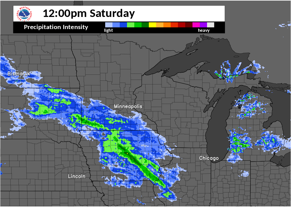
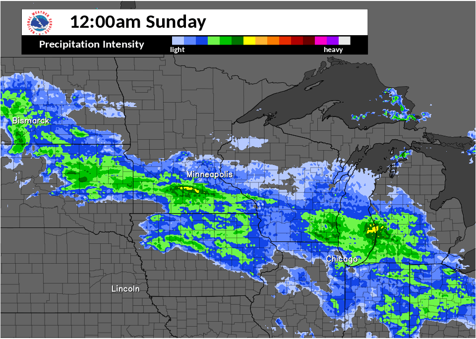
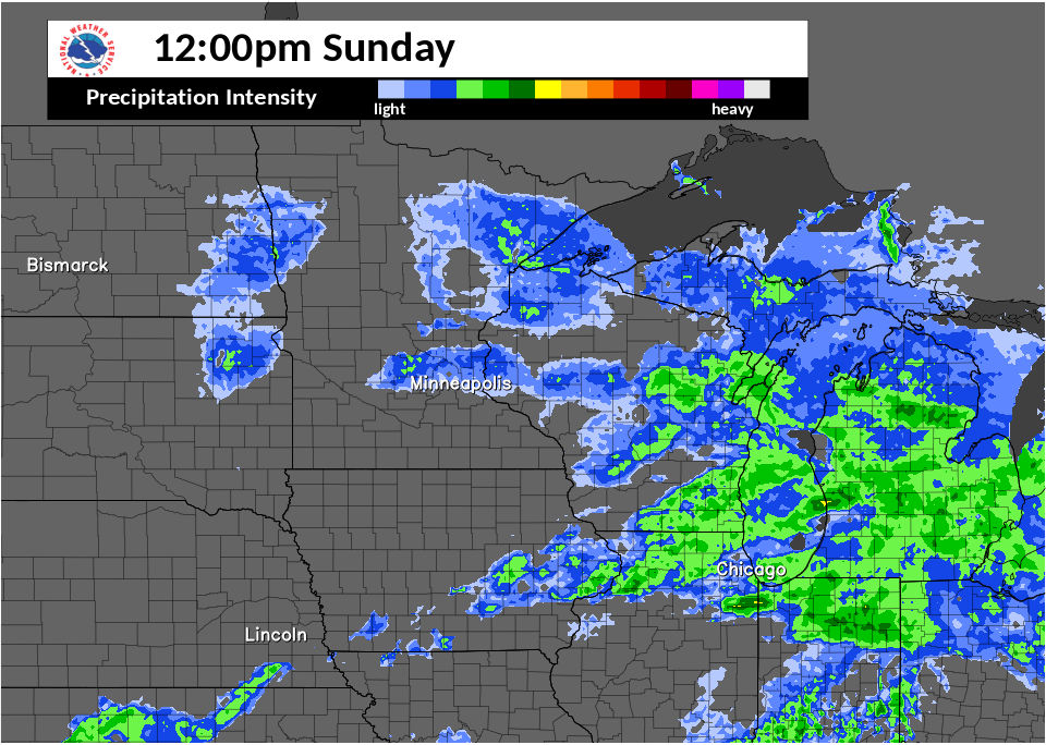
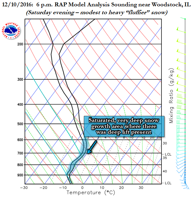
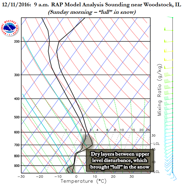
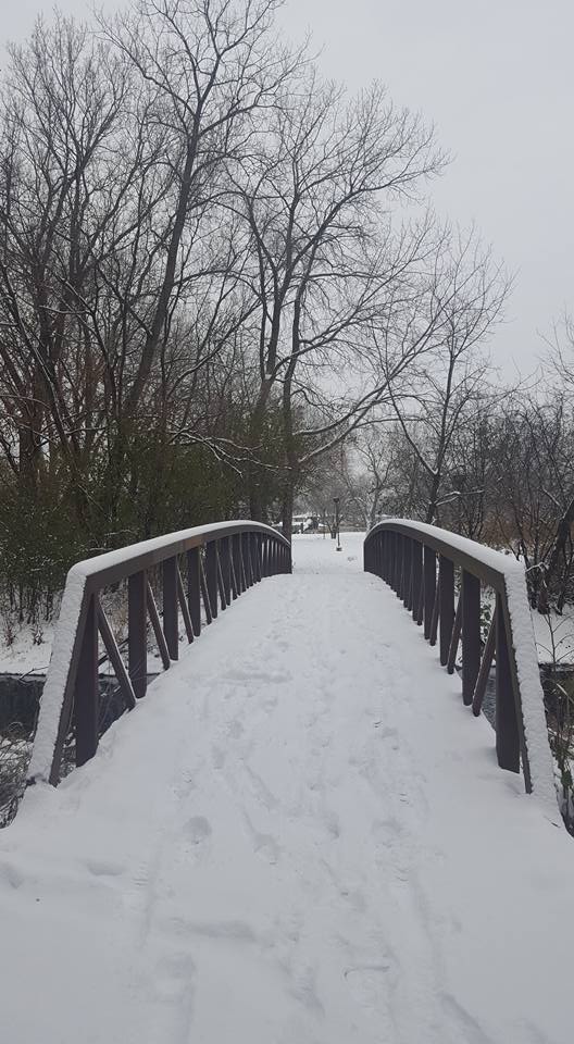
The second snow event of the season, this one also during the weekend, was a longer duration event that was truly made up of two meteorological systems. The first was a minor upper disturbance that produced lift and saturation in an inherent cold atmosphere, favorable for larger dendritic snowflake growth. The second system was about 12 hours later, with occasional flurries/light snow in-between. This second upper level disturbance was a stronger one and steered high moisture northward over the area. The snow caused by this event was a more wet snow, with snowflakes sticking together as they fell. Both "bursts" of snow activity had rates near or over one inch per hour at times north of I-80.
 |
 |
 |
| December 10, 2016: Radar loop from noon to midnight | December 11, 2016: Radar loop from midnight to noon | December 11, 2016: Radar loop from noon to midnight |
 |
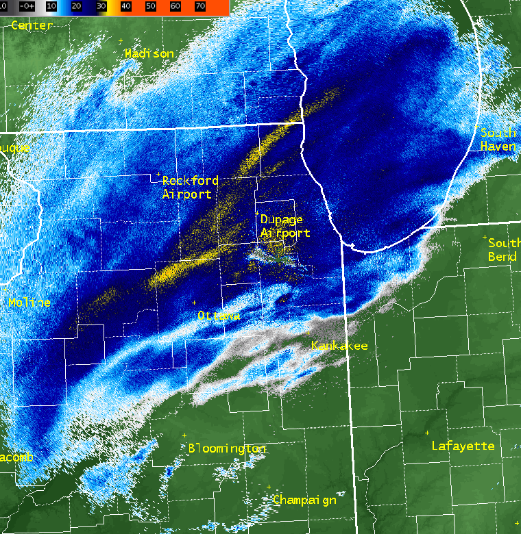
| December 11, 2016: NWS Chicago Doppler Radar Reflectivity loop from 9 a.m. through 10 p.m. The yellow areas indicate over 30 dBZ echoes of snow that are indicative of a high number of snowflakes or large snowflakes, or both. These echoes were often in stripes correlating with snow bands. The forcing for this was a developing frontogenetic circulation in response to the deepening of the weather system and tightening of the temperature gradient aloft. |
 |
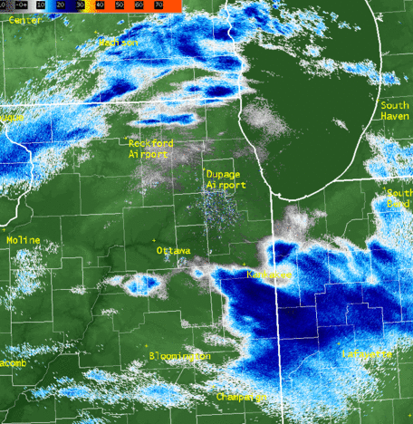
| December 11, 2016: NWS Chicago Doppler Radar Reflectivity image from 4:45 pm Heavy snow bands across Lake and McHenry Counties southwest through DuPage, Kane, DeKalb, and LaSalle Counties. |
 |
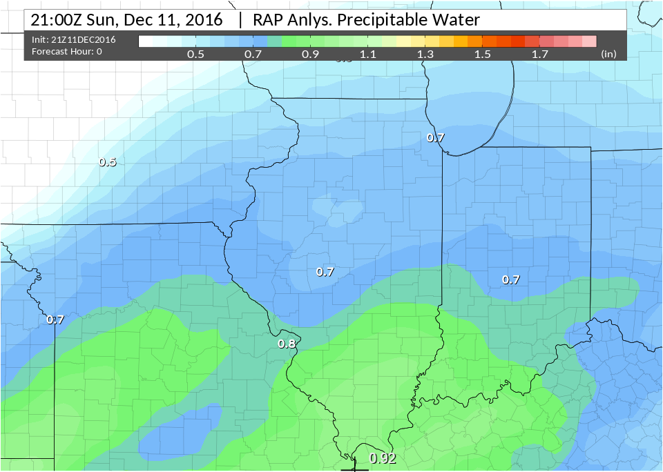 |
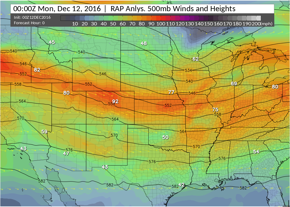
| December 11, 2016: RAP Analysis of 500 mb at 6 p.m. The colors indicate the mid-level winds and the black lines heights. The short wave trough moving across the Upper Midwest and the associated jet promoted widespread lift and deformation across northern Illinois, which favored the development of the frontogenetic circulation and snow bands. | December 11, 2016: RAP Analysis of Precipitable Water (PWAT) at 3 p.m. Moisture values in excess of 0.6 inches are high for all snow events. Similar to the prior Sunday, the snow became more wet and coupled with the light winds at the surface, it stuck to many objects such as trees. The 6 pm NWS Lincoln, IL weather balloon confirmed these values with 0.71" PWAT observed. |
 |
 |
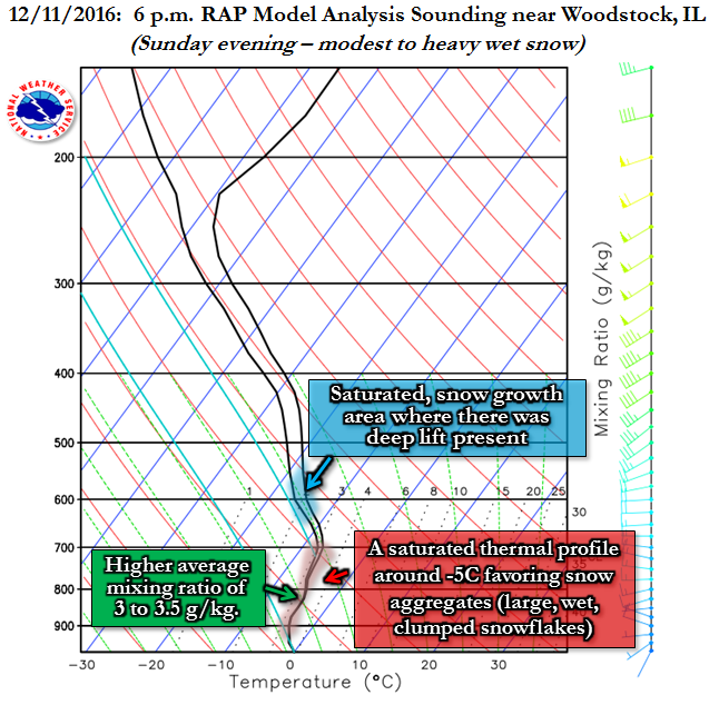 |
| December 10, 2016 6 p.m.: RAP model analysis in far northern Illinois | December 11, 2016 9 a.m.: RAP model analysis in far northern Illinois | December 11, 2016 6 p.m.: RAP model analysis in far northern Illinois |
Additional
Photos
 |
 |
| Photo courtesy of Christian Lyon, Lakeview area of Chicago, IL | Photo courtesy of Christine McEvilly in the southwest Suburbs |
Links
 |
Media use of NWS Web News Stories is encouraged!
|
|

