|
Fast Facts:
|
  |
Coldest Temperatures
Public Information Statement
National Weather Service Chicago IL
138 PM CST Sat Jan 6 2018/ 238 PM EST Sat Jan 6 2018

...Top Ten Low Temperatures from Dec. 25 through Jan. 6...

Observations are collected from a variety of sources with varying
equipment and exposures. We thank all volunteer weather observers
for their dedication. Not all data listed are considered official.

LOW TEMPERATURES

Location                     Temp       Date(s)        Provider
----------------------------------------------------------------
Watseka                      -22 F       01/01-03        COOP
Pontiac Airport              -21 F       01/01           AWOS
Rochelle Airport             -21 F       01/06           AWOS
Rensselaer,IN                -20 F       01/02           COOP
Dixon                        -19 F       01/02-04        COOP
Marseilles Lock/Dam          -19 F       01/02-04        COOP
Dwight                       -18 F       01/02           COOP
Kankakee Airport             -18 F       01/02           AWOS
Paw Paw                      -18 F       01/02           COOP
Peru Airport                 -18 F       01/01-02        AWOS
Rochelle                     -18 F       01/03           COOP
Sugar Grove - Aurora Airport -18 F       01/06           ASOS
Kankakee                     -17 F       01/02           COOP
Morris Airport               -17 F       01/02           AWOS
Ottawa                       -17 F       01/01           COOP
Paxton                       -17 F       01/01-02        COOP
Rensselaer, IN Airport       -17 F       01/02           AWOS
Joliet Airport               -16 F       01/02           AWOS
McHenry Statton Lock/Dam     -16 F       01/02           COOP
Morris                       -16 F       01/01           COOP
Rockford Airport             -16 F       01/06           ASOS
Romeoville - Lewis Airport   -16 F       01/02           AWOS
De Kalb                      -15 F       01/01-03        COOP
Aurora                       -14 F       01/02-03        COOP
Du Page Airport              -14 F       01/02           ASOS
Joliet                       -14 F       01/02-03        COOP
Lowell, IN                   -14 F       12/27           COOP
Park Forest                  -14 F       01/03           COOP
De Kalb Airport              -14 F       01/02           AWOS
Barrington                   -13 F       01/02           COOP
Coal City 4NNW               -13 F       01/06           COOP
Elgin                        -13 F       01/02           COOP
Indiana Dunes Nat. Lake.     -13 F       01/02           COOP
Valparaiso, IN Airport       -13 F       01/02           COOP
New Year's Cold
 |
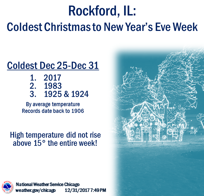 |
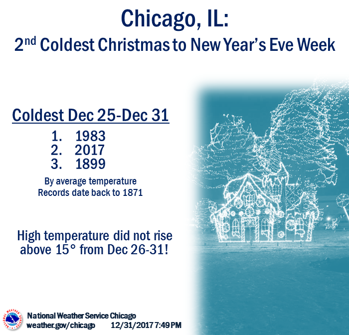
| Christmas to New Year's Eve: Chicago | Christmas to New Year's Eve: Rockford |
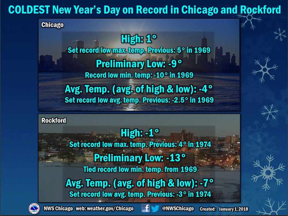
Chicago's high temperature of 1° was the coldest high temperature for the city since January 6, 2014 when the high temperature was -2°.
January 1 Cold
Public Information Statement
National Weather Service Chicago IL
958 AM CST Mon Jan 1 2018 /1058 AM EST Mon Jan 1 2018/

...Low Temperature and Wind Chills from New Year`s Day Morning...

Observations are collected from a variety of sources with varying
equipment and exposures. We thank all volunteer weather observers
for their dedication. Not all data listed are considered official.

LOW TEMPERATURES

Location                     Temp      Time/Date       Provider
---------------------------------------------------------------
Pontiac Airport              -21 F     0735 AM 01/01   AWOS
Peru Airport                 -19 F     0755 AM 01/01   AWOS
1 WNW Campus                 -19 F     0735 AM 01/01   CWOP
4 SW Ottawa                  -17 F     0800 AM 01/01   COOP
2 WSW Paxton                 -17 F     0630 AM 01/01   COOP
2 WNW Dixon                  -17 F     0734 AM 01/01   CWOP
1 W Streator                 -17 F     0801 AM 01/01   CWOP
1 E Paw Paw                  -17 F     0700 AM 01/01   COOP
2 WNW Dixon                  -17 F     0806 AM 01/01   CWOP
Milford                      -17 F     0747 AM 01/01   CWOP
Rochelle Airport             -17 F     0715 AM 01/01   AWOS
Morris Airport               -14 F     0815 AM 01/01   AWOS
Kankakee Airport             -14 F     0835 AM 01/01   AWOS
De Kalb Airport              -13 F     0755 AM 01/01   AWOS
Sugar Grove - Aurora Airport -13 F     0752 AM 01/01   ASOS
Rockford Airport             -13 F     0754 AM 01/01   ASOS
Romeoville - Lewis Airport   -12 F     0715 AM 01/01   AWOS
Dupage Airport               -12 F     0752 AM 01/01   ASOS
Joliet Airport               -10 F     0755 AM 01/01   AWOS
Rensselaer Airport            -9 F     0835 AM 01/01   AWOS
Chicago O`Hare                -9 F     0751 AM 01/01   ASOS
Lansing Airport               -8 F     0815 AM 01/01   AWOS
Wheeling - Chi Exec Airport   -8 F     0752 AM 01/01   ASOS
Waukegan Airport              -8 F     0755 AM 01/01   ASOS
Chicago Midway                -7 F     0753 AM 01/01   ASOS
Gary Airport                  -6 F     0745 AM 01/01   AWOS
Valparaiso Airport            -6 F     0756 AM 01/01   ASOS


LOW WIND CHILLS

Location                 Wind Chill    Time/Date       Provider
---------------------------------------------------------------
Pontiac Airport              -42 F     0755 AM 01/01   AWOS
Peru Airport                 -41 F     0755 AM 01/01   AWOS
De Kalb Airport              -36 F     0735 AM 01/01   AWOS
Sugar Grove - Aurora Airport -35 F     0752 AM 01/01   ASOS
Morris Airport               -34 F     0915 AM 01/01   AWOS
Dupage Airport               -33 F     0752 AM 01/01   ASOS
Kankakee Airport             -33 F     0815 AM 01/01   AWOS
Rockford Airport             -33 F     0454 AM 01/01   ASOS
Rochelle Airport             -32 F     0655 AM 01/01   AWOS
Romeoville - Lewis Airport   -32 F     0855 AM 01/01   AWOS
Rensselaer Airport           -29 F     0755 AM 01/01   AWOS
Chicago O`Hare               -29 F     0851 AM 01/01   ASOS
Gary Airport                 -28 F     0745 AM 01/01   AWOS
Waukegan Airport             -28 F     0655 AM 01/01   ASOS
Chicago Midway               -26 F     0553 AM 01/01   ASOS
Valparaiso Airport           -25 F     0756 AM 01/01   ASOS
Lansing Airport              -25 F     0755 AM 01/01   AWOS
Wheeling - Chi Exec Airport  -25 F     0852 AM 01/01   ASOS
Joliet Airport               -25 F     0935 AM 01/01   AWOS
January 2 Cold
Public Information Statement
National Weather Service Chicago IL
1145 AM CST Tue Jan 2 2018 /1245 PM EST Tue Jan 2 2018/

...Low Temperature and Wind Chills from January 2nd Morning...

Observations are collected from a variety of sources with varying
equipment and exposures. We thank all volunteer weather observers
for their dedication. Not all data listed are considered official.

LOW TEMPERATURES

Location                     Temp      Time/Date       Provider
---------------------------------------------------------------
Pontiac Airport              -20 F     0555 AM 01/02   AWOS
Streator                     -20 F     0800 AM 01/02   AWS
Manteno                      -19 F     0705 AM 01/02   AWS
Peru Airport                 -18 F     0755 AM 01/02   AWOS
Beecher                      -18 F     0734 AM 01/02   AWS
Rochelle Airport             -18 F     0735 AM 01/02   AWOS
Grant Park                   -18 F     0728 AM 01/02   CWOP
Kankakee Airport             -18 F     0635 AM 01/02   AWOS
Dwight                       -18 F     0402 AM 01/02   CWOP
2 ESE Dixon                  -17 F     0854 AM 01/02   NONFEDAWOS
Rensselaer Airport           -17 F     0735 AM 01/02   AWOS
Morris Airport               -17 F     0715 AM 01/02   AWOS
Milford                      -17 F     0747 AM 01/02   CWOP
3 WSW Fowler                 -16 F     0750 AM 01/02   INDOT
Sugar Grove - Aurora Airport -16 F     0552 AM 01/02   ASOS
Romeoville - Lewis Airport   -15 F     0735 AM 01/02   AWOS
Rockford Airport             -15 F     0654 AM 01/02   ASOS
Joliet Airport               -14 F     0555 AM 01/02   AWOS
Dupage Airport               -14 F     0652 AM 01/02   ASOS
De Kalb Airport              -13 F     0735 AM 01/02   AWOS
Valparaiso Airport           -13 F     0620 AM 01/02   ASOS
Lansing Airport              -12 F     0615 AM 01/02   AWOS
Chicago Midway                -9 F     0753 AM 01/02   ASOS
Chicago O`Hare                -8 F     0751 AM 01/02   ASOS
Gary Airport                  -8 F     0745 AM 01/02   AWOS

LOW WIND CHILLS

Location                 Wind Chill    Time/Date       Provider
---------------------------------------------------------------
Rochelle Airport             -36 F     0855 AM 01/02   AWOS
Rensselaer Airport           -36 F     0415 AM 01/02   AWOS
Kankakee Airport             -35 F     0455 AM 01/02   AWOS
Pontiac Airport              -35 F     0735 AM 01/02   AWOS
Peru Airport                 -35 F     0415 AM 01/02   AWOS
Valparaiso Airport           -33 F     0638 AM 01/02   ASOS
Sugar Grove - Aurora Airport -32 F     1252 AM 01/02   ASOS
Morris Airport               -32 F     0515 AM 01/02   AWOS
De Kalb Airport              -31 F     0135 AM 01/02   AWOS
Dupage Airport               -31 F     0752 AM 01/02   ASOS
Rockford Airport             -31 F     0754 AM 01/02   ASOS
Lewis Airport, Romeoville    -30 F     0735 AM 01/02   AWOS
Chicago Midway               -29 F     0753 AM 01/02   ASOS
Lansing Airport              -28 F     0615 AM 01/02   AWOS
Joliet Airport               -26 F     1015 AM 01/02   AWOS
Chicago O`Hare               -25 F     0751 AM 01/02   ASOS
Gary Airport                 -24 F     0745 AM 01/02   AWOS
Waukegan Airport             -20 F     0955 PM 01/01   ASOS
Additional Info
 |
Media use of NWS Web News Stories is encouraged! Please acknowledge the NWS as the source of any news information accessed from this site. Additional recaps can be found on the NWS Chicago Past Events Page |
|

