Overview
|
Fast Facts:
|
 July 19-23 Regional Radar Mosaic Loop (still images courtesy of College of DuPage Meteorology Department) |
Active Weather
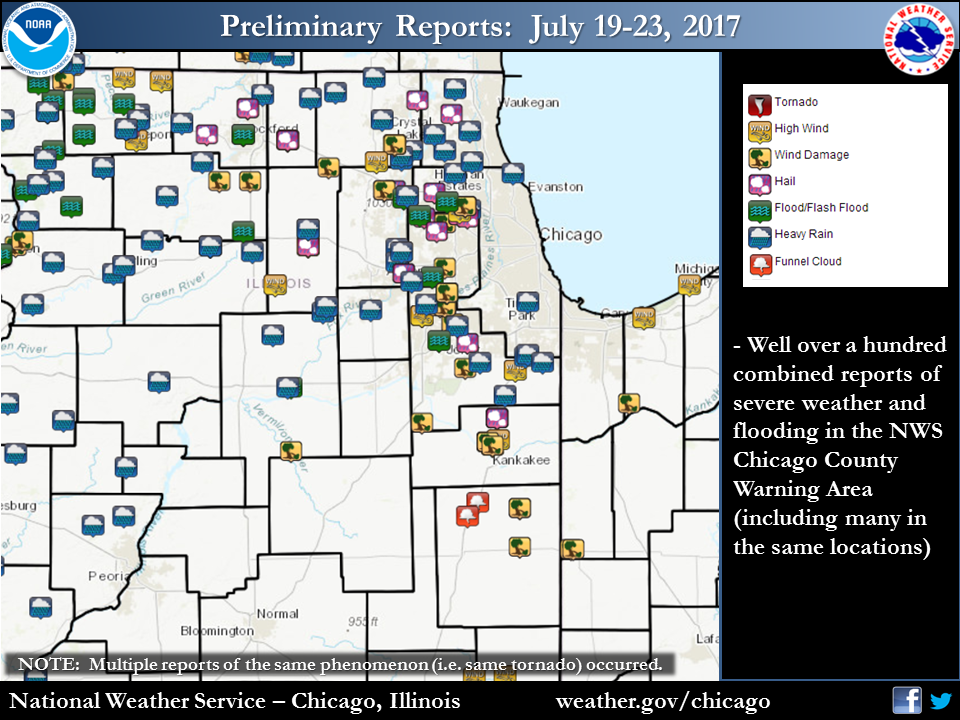 |
| July 19-23 Storm Reports |
During July 19-23, the NWS Chicago office issued 27 Severe Thunderstorm Warnings, 2 Tornado Warnings, 2 Large Flash Flood Warnings, Numerous Flood Advisories, and 6 Special Marine Warnings for southern Lake Michigan waters.
This has been an active month of weather as a whole. From July 6-23, the NWS Storm Prediction Center (SPC) has had at least part of the area under some form of severe weather risk 14 of the 18 days (78%) in their Day 1 Outlook. 11 of those days (61%) were a Slight Risk (Cat 2) or higher.
The rounds of heavy rainfall also continued and furthered ongoing river flooding across northern Illinois that had began with the heavy rain on July 12. This especially included the Des Plaines and Fox River basins. Here is a look at the hydrograph for the Fox River at Algonquin during this five day stretch.
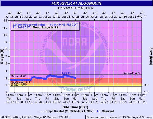 |
| Fox River at Algonquin Hydrograph |
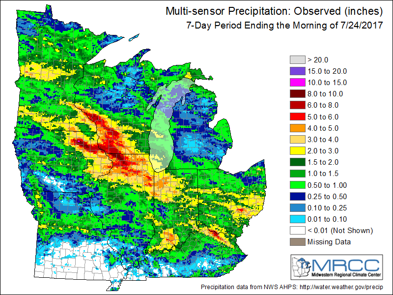
Rainfall
 |
 |
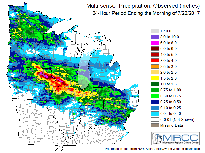
| Local Area Rainfall | Regional Rainfall |
Public Information Statement
National Weather Service Chicago IL
348 AM CDT Tue Jul 25 2017 /448 AM EDT Tue Jul 25 2017/
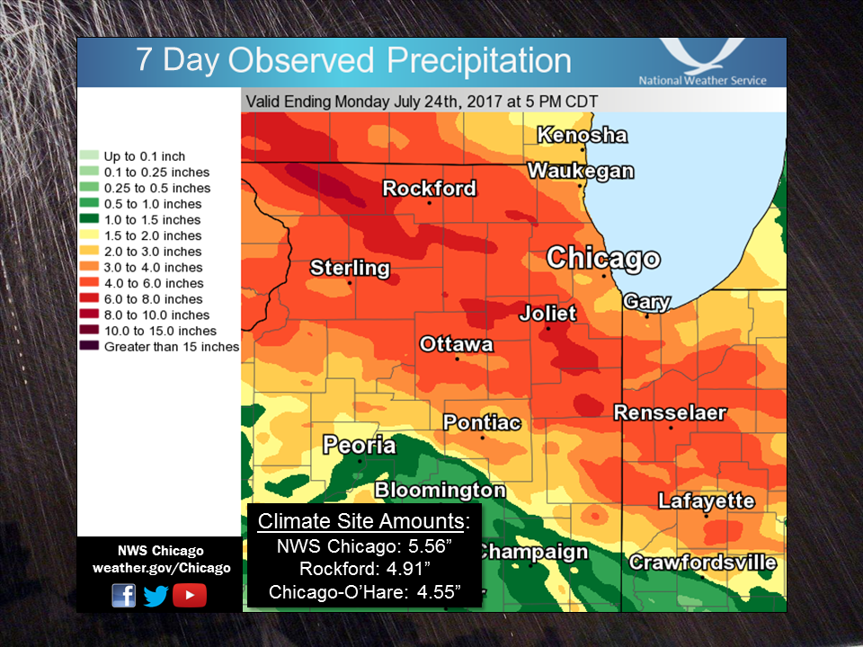
...Five Day Rainfall Totals From July 19-23...
The following are rainfall amounts for the active 5-day stretch of
July 19-23, as measured by NWS Cooperative Observers.
5-Day Rainfall
Location (County): Amt(Inches)
-------------------------------------------------------
Peotone (Will) 6.53
Dixon 1W (Lee) 6.30
Steward 3S (Lee) 6.11
Monee (Will) 6.05
Manhattan 5ENE (Will) 5.55
Elgin (Kane) 5.43
Rochelle (Ogle) 5.43
Mendota 2SE (LaSalle) 5.23
Joliet 2N (Will) 5.22
Woodstock 5NW (McHenry) 5.12
Genoa 2SW (DeKalb) 4.96
Yorkville 2SE (Kendall) 4.96
Kankakee (Kankakee) 4.91
Bourbonnais 3NW (Kankakee) 4.86
Momence 5ENE (Kankakee) 4.80
Mundelein 4WSW (Lake IL) 4.70
Park Forest (Cook) 4.65
Marseilles Lock and Dam (LaSalle) 4.58
Paw Paw 2S (Lee) 4.56
Harvard (McHenry) 4.54
St Anne (Kankakee) 4.44
Aurora (Kane) 4.31
Barrington 3SW (Cook) 4.27
DeKalb (DeKalb) 4.11
Hebron (Porter) 4.07
Rensselaer (Jasper) 4.07
Roscoe 2SE (Winnebago) 4.02
The following are rainfall amounts for the active 5-day stretch of
July 19-23, as measured at long term climate sites.
5-Day Rainfall
Location: Amt(Inches)
-------------------------------------------------------
NWS Chicago (Romeoville) 5.56
Rockford International Airport 4.91
Chicago O`Hare International Airport 4.55
$$
MTF
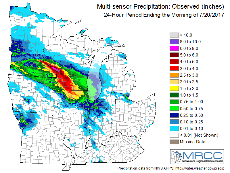
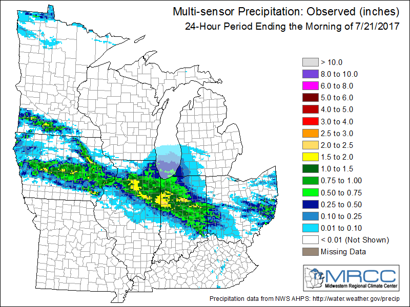
July 19-20
 |
 |
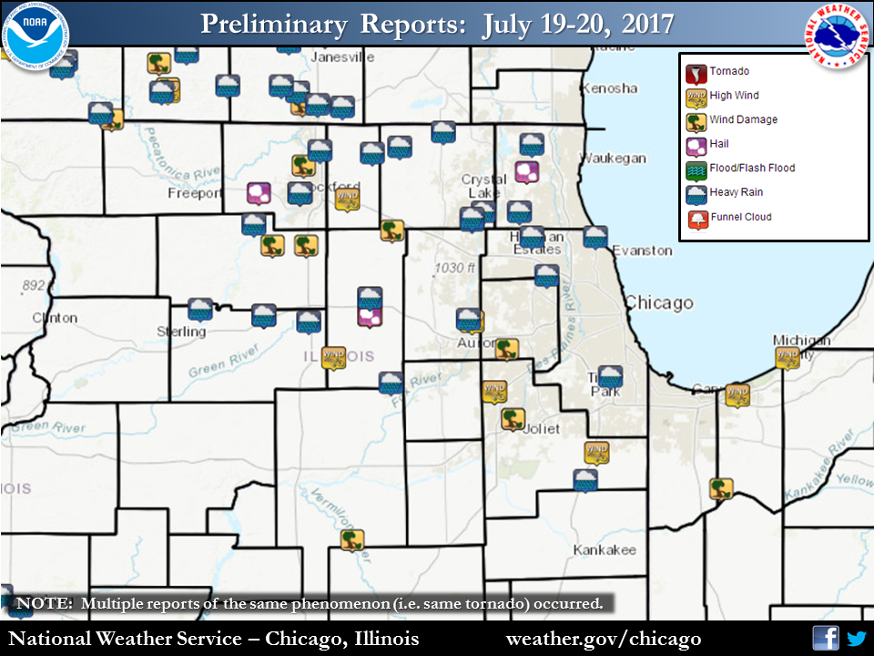 |
| July 19-Early Morning of July 20 Rainfall | July 20 (after sunrise) Rainfall | Storm Reports |
Rainfall
PUBLIC INFORMATION STATEMENT
NATIONAL WEATHER SERVICE CHICAGO IL
1001 AM CDT THU JUL 20 2017

...MORNING RAINFALL ROUNDUP...

   THE FOLLOWING ARE RAIN AMOUNTS FOR THE PREVIOUS 24-HOURS
   AS MEASURED IN THE MORNING BY NWS COOPERATIVE OBSERVERS
   AND COCORAHS OBSERVERS.
   OBSERVATIONS ARE USUALLY TAKEN BETWEEN 6 AND 8 AM.

   24-HOUR RAINFALL AMOUNTS
       FOR THURSDAY(07/20/17)...


ILLINOIS                                       RAIN
  LOCATION (COUNTY):                           FALL (IN)

  ROCKFORD 6S (WINNEBAGO)......................3.65
  ROCKFORD (WINNEBAGO).........................3.39
  ASHTON (LEE).................................3.06
  STEWARD (LEE)................................2.98
  BYRON 3N (OGLE)..............................2.94
  POLO (OGLE)..................................2.88
  LAKE IN THE HILLS 2.5W (MCHENRY).............2.75
  HARVARD (MCHENRY)............................2.73
  BULL VALLEY 2WNW (MCHENRY)...................2.57
  CARY (MCHENRY)...............................2.54
  ROCKFORD 1NW (WINNEBAGO).....................2.53
  DIXON 2SW (LEE)..............................2.51
  ROCKFORD (WINNEBAGO).........................2.50
  DIXON (LEE)..................................2.47
  WOODSTOCK 5NW (MCHENRY)......................2.46
  GENOA (DE KALB)..............................2.45
  WOODSTOCK 4SW (MCHENRY)......................2.43
  KINGSTON 2WNW (DE KALB)......................2.42
  SOUTH BELOIT 2SE (WINNEBAGO).................2.39
  ELGIN 8WSW (KANE)............................2.38
  DIXON 3NNW (LEE).............................2.36
  WONDER LAKE 1WNW (MCHENRY)...................2.36
  BELVIDERE (BOONE)............................2.35
  WOODSTOCK 1SSW (MCHENRY).....................2.27
  HUNTLEY (MCHENRY)............................2.25
  CRYSTAL LAKE 1WSW (MCHENRY)..................2.23
  CAPRON (BOONE)...............................2.17
  LAKE FOREST 2NNE (LAKE)......................2.16
  ROSCOE 2ESE (WINNEBAGO)......................2.16
  ROSCOE 2SE (WINNEBAGO).......................2.16
  ROCKFORD 3NE (WINNEBAGO).....................2.11
  AMBOY (LEE)..................................2.10
  DE KALB (DE KALB)............................2.10
  BELVIDERE 2NW (BOONE)........................2.10
  STERLING 4NE (LEE)...........................2.08
  HEBRON (MCHENRY).............................2.07
  DE KALB (DE KALB)............................2.02
  ROSELLE 1ESE (DU PAGE).......................2.00
  FOX LAKE 2SE (LAKE)..........................1.99
  HANOVER PARK 2SSW (DU PAGE)..................1.96
  CHICAGO 6NNE (COOK)..........................1.95
  ELGIN (KANE).................................1.93
  ELGIN 1S (KANE)..............................1.93
  SUBLETTE (LEE)...............................1.90
  RIVER FOREST 1SSE (COOK).....................1.84
  WAUKEGAN 2N (LAKE)...........................1.83
  PLANO (KENDALL)..............................1.77
  ARLINGTON HEIGHTS 3SSW (COOK)................1.76
  SOMONAUK 2NE (DE KALB).......................1.75
  BARRINGTON (LAKE)............................1.74
  WADSWORTH 1SSE (LAKE)........................1.74
  PLAINFIELD 3NNW (WILL).......................1.74
  LAKE IN THE HILLS 1ESE (MCHENRY).............1.72
  GURNEE 2W (LAKE).............................1.69
  WINNETKA 1ESE (COOK).........................1.67
  PEOTONE (WILL)...............................1.66
  MENDOTA (LA SALLE)...........................1.65
  DE KALB 1SW (DE KALB)........................1.64
  OAK PARK 1NNE (COOK).........................1.62
  SOMONAUK (DE KALB)...........................1.62
  ELBURN (KANE)................................1.60
  HOFFMAN ESTATES 5W (COOK)....................1.59
  CARY (MCHENRY)...............................1.59
  PARK RIDGE 1WNW (COOK).......................1.56
  STREAMWOOD (COOK)............................1.54
  PAW PAW (LEE)................................1.54
  ELGIN 1WSW (KANE)............................1.52
  SCHAUMBURG 2E (COOK).........................1.44
  BOTANIC GARDENS (COOK).......................1.43
  ALGONQUIN 1N (MCHENRY).......................1.43
  ELGIN 2W (KANE)..............................1.42
  PLAINFIELD (WILL)............................1.42
  HARWOOD HEIGHTS (COOK).......................1.41
  OHARE (COOK).................................1.40
  GILBERTS (KANE)..............................1.39
  SLEEPY HOLLOW 1SE (KANE).....................1.38
  OAK PARK 1SW (COOK)..........................1.36
  ST. CHARLES (KANE)...........................1.36
  RAVENSWOOD MANOR (COOK)......................1.35
  LAKEMOOR 2NW (MCHENRY).......................1.35
  ROCHELLE (OGLE)..............................1.34
  PALATINE 1E (COOK)...........................1.33
  EVANSTON 1N (COOK)...........................1.31
  ELK GROVE VILLAGE 1ESE (COOK)................1.31
  OSWEGO 5SSE (KENDALL)........................1.31
  YORKVILLE 2SE (KENDALL)......................1.31
  PARK RIDGE (COOK)............................1.30
  CORTLAND (DE KALB)...........................1.30
  ZION (LAKE)..................................1.28
  OTTAWA 1NW (LA SALLE)........................1.26
  GLENCOE (COOK)...............................1.25
  WESTMONT 1SSW (DU PAGE)......................1.25
  PALATINE 1NNE (COOK).........................1.24
  WAUKEGAN 2E (LAKE)...........................1.22
  NORTH UTICA 6N (LA SALLE)....................1.22
  WINTHROP HARBOR 1SSW (LAKE)..................1.21
  LINCOLNWOOD 2E (COOK)........................1.20
  MONEE (WILL).................................1.20
  BATAVIA 2WNW (KANE)..........................1.17
  HIGHWOOD 1S (LAKE)...........................1.17
  BERWYN 1NW (COOK)............................1.15
  LINCOLNSHIRE 1N (LAKE).......................1.14
  BANNOCKBURN (LAKE)...........................1.14
  LAKE ZURICH 1N (LAKE)........................1.14
  WOODSTOCK (MCHENRY)..........................1.13
  ELGIN (KANE).................................1.12
  ELMHURST 2SE (DU PAGE).......................1.10
  LANSING (COOK)...............................1.10
  LEMONT (COOK)................................1.08
  NAPERVILLE 2ESE (DU PAGE)....................1.08
  MANHATTAN 2SE (WILL).........................1.08
  DOWNERS GROVE 0.4NNE (DU PAGE)...............1.06
  BATAVIA 1WSW (KANE)..........................1.06
  BUFFALO GROVE 2N (LAKE)......................1.06
  WHEELING (COOK)..............................1.06
  OAK PARK 2S (COOK)...........................1.04
  ELGIN 2WNW (KANE)............................1.04
  ST. CHARLES 6NW (KANE).......................1.04
  LAKEMOOR 2SE (LAKE)..........................1.04
  BATAVIA 1WNW (KANE)..........................1.03
  CHICAGO 5NE (COOK)...........................1.01
  LOMBARD 1WSW (DU PAGE).......................1.00
  MINOOKA (GRUNDY).............................1.00
  HOMER GLEN 1ENE (WILL).......................1.00
  LAKE ZURICH (LAKE)...........................1.00
  OTTAWA (LA SALLE)............................1.00
  SHERIDAN 3SSE (LA SALLE).....................0.99
  NEW LENOX 3ENE (WILL)........................0.99
  LAKE BLUFF 1W (LAKE).........................0.98
  MUNDELEIN (LAKE).............................0.98
  RIVERWOODS (LAKE)............................0.97
  WAUKEGAN (LAKE)..............................0.97
  DARIEN (DU PAGE).............................0.91
  OAK LAWN 2SE (COOK)..........................0.90
  GENEVA 4WSW (KANE)...........................0.90
  ELBURN (KANE)................................0.87
  AMBOY (LEE)..................................0.86
  MAZON 0.5ENE (GRUNDY)........................0.85
  SUGAR GROVE 1ENE (KANE)......................0.84
  EARLVILLE 5NNE (DE KALB).....................0.80
  KANKAKEE 4WNW (KANKAKEE).....................0.78
  SUGAR GROVE 1NE (KANE).......................0.78
  AURORA (KANE)................................0.77
  LAKE VILLA 1SSW (LAKE).......................0.77
  LAKE VILLA 2WSW (LAKE).......................0.77
  LA GRANGE PARK 1SSW (COOK)...................0.76
  AURORA (KANE)................................0.75
  COAL CITY 4NNW (GRUNDY)......................0.75
  CARBON HILL 3.1N (GRUNDY)....................0.75
  BATAVIA (KANE)...............................0.73
  LISLE (DU PAGE)..............................0.73
  GLEN ELLYN 2SSE (DU PAGE)....................0.72
  ROMEOVILLE (WILL)............................0.71
  LISLE 1SW (DU PAGE)..........................0.68
  MANHATTAN 1ESE (WILL)........................0.68
  GLEN ELLYN 1WSW (DU PAGE)....................0.67
  NAPERVILLE 1NW (DU PAGE).....................0.67
  MORRIS 6ESE (GRUNDY).........................0.66
  NEW LENOX 2SE (WILL).........................0.66
  CHEBANSE (KANKAKEE)..........................0.65
  NORTH AURORA 2NE (KANE)......................0.65
  MIDWAY (COOK)................................0.64
  MORRIS (GRUNDY)..............................0.64
  AURORA 4SE (DU PAGE).........................0.63
  PLAINFIELD 5SW (KENDALL).....................0.62
  CHANNAHON 2SSE (WILL)........................0.62
  WESTMONT (DU PAGE)...........................0.62
  PALOS PARK 1SW (COOK)........................0.61
  AURORA 4SE (DU PAGE).........................0.61
  NAPERVILLE 2ESE (DU PAGE)....................0.61
  MONTGOMERY 1SSE (KENDALL)....................0.61
  ELMHURST (DU PAGE)...........................0.60
  JOLIET 2N (WILL).............................0.60
  CHICAGO 6ESE (COOK)..........................0.59
  WEST CHICAGO (DU PAGE).......................0.58
  CAROL STREAM (DU PAGE).......................0.58
  MANHATTAN 5ENE (WILL)........................0.58
  MIDLOTHIAN 1SE (COOK)........................0.56
  LOCKPORT 1SE (WILL)..........................0.56
  MORRIS 2N (GRUNDY)...........................0.55
  MUNDELEIN 2WNW (LAKE)........................0.54
  MIDLOTHIAN (COOK)............................0.53
  MANHATTAN (WILL).............................0.52
  PLAINFIELD 2SSE (WILL).......................0.51
  WHEATON 2NNE (DU PAGE).......................0.50
  CRETE 3E (WILL)..............................0.50
  WILMINGTON 6NW (WILL)........................0.50

INDIANA                                        RAIN
  LOCATION (COUNTY):                           FALL (IN)

  HOBART 2E (LAKE).............................1.83
  WHEATFIELD 4WSW (JASPER).....................1.59
  DE MOTTE 3SE (JASPER)........................1.55
  LAKE VILLAGE 8SE (NEWTON)....................1.25
  HIGHLAND 1ESE (LAKE).........................1.00
  MUNSTER 2NNW (LAKE)..........................0.96
  VALPARAISO 2NW (PORTER)......................0.95
  RENSSELAER 10NNE (JASPER)....................0.84
  VALPARAISO 3WSW (PORTER).....................0.76
  DE MOTTE 6S (JASPER).........................0.75
  WHEATFIELD 5W (JASPER).......................0.72
  GRIFFITH 1N (LAKE)...........................0.70
  GARY 4SSW (LAKE).............................0.64
  VALPARAISO 2WSW (PORTER).....................0.64
  CHESTERTON 4E (PORTER).......................0.60
  ST. JOHN (LAKE)..............................0.59
  (W9MAL)MERRILLVILLE 2NNW (LAKE)..............0.59
  VALPARAISO 5WSW (PORTER).....................0.54
  LAKES OF THE FOUR SEASONS 2NNE (PORTER)......0.50
Storm Reports
PRELIMINARY LOCAL STORM REPORT...SUMMARY
NATIONAL WEATHER SERVICE CHICAGO/ROMEOVILLE IL
1207 AM CDT THU JUL 20 2017

..TIME...   ...EVENT...      ...CITY LOCATION...     ...LAT.LON...
..DATE...   ....MAG....      ..COUNTY LOCATION..ST.. ...SOURCE....
            ..REMARKS..

0813 PM     TSTM WND DMG     STILLMAN VALLEY         42.10N 89.18W
07/19/2017                   OGLE               IL   BROADCAST MEDIA

            REPORTS OF TREES DOWN, AND POWER IS OUT.

0813 PM     TSTM WND GST     ROCKFORD                42.27N 89.06W
07/19/2017  M58.00 MPH       WINNEBAGO          IL   ASOS

0824 PM     TSTM WND DMG     MACHESNEY PARK          42.36N 89.04W
07/19/2017                   WINNEBAGO          IL   BROADCAST MEDIA

            POWERLINES DOWN IN MACHESNEY PARK.

0830 PM     TSTM WND DMG     ASHTON                  41.87N 89.22W
07/19/2017                   LEE                IL   TRAINED SPOTTER

            6 INCH WILLOW TREE BRANCH BROKE OFF TOWARDS THE TOP OF A
            TREE.

0830 PM     TSTM WND DMG     ASHTON                  41.87N 89.22W
07/19/2017                   LEE                IL   TRAINED SPOTTER

            6 INCH WILLOW TREE BRANCH BROKE OFF TOWARDS THE TOP OF A
            TREE NEAR QUARRY/STONE ROAD.

0835 PM     HEAVY RAIN       SSW ASHTON              41.87N 89.22W
07/19/2017  M0.99 INCH       LEE                IL   COCORAHS

            MEASURED IN 10 MINUTES. MINOR FLOODING.

0835 PM     TSTM WND DMG     3 E DAVIS JUNCTION      42.10N 89.03W
07/19/2017                   OGLE               IL   PUBLIC

            POWER OUT IN THE MONROE CENTER WITH MULTIPLE LINES DOWN
            IN NE OGLE COUNTY.

0840 PM     TSTM WND GST     BELVIDERE               42.25N 88.85W
07/19/2017  E70.00 MPH       BOONE              IL   AMATEUR RADIO

            70 MPH WIND GUST AT BOONE COUNTY FAIRGROUNDS.

0849 PM     TSTM WND GST     4 S DE KALB             41.87N 88.75W
07/19/2017  E70.00 MPH       DE KALB            IL   TRAINED SPOTTER

            70 MPH GUST WITH 50+ MPH SUSTAINED WINDS.

0850 PM     TSTM WND DMG     DE KALB                 41.93N 88.75W
07/19/2017                   DE KALB            IL   PUBLIC

            TREE DOWN ON HOUSE ON N 12TH STREET, OTHER TREES AND
            POWERLINES DOWN IN THE CITY OF DE KALB.

0856 PM     TSTM WND DMG     4 NNE GENOA             42.15N 88.65W
07/19/2017                   MCHENRY            IL   PUBLIC

            LARGE TREE DOWN ON HIGHWAY 23 SOUTH OF MARENGO NEAR
            COUNTY LINE. TIME ESTIMATED.

0856 PM     FLASH FLOOD      DE KALB                 41.93N 88.75W
07/19/2017                   DE KALB            IL   AMATEUR RADIO

            3-4 INCHES OF WATER ON ROADS NEAR HILLCREST/NORMAL
            STREET.

0856 PM     HAIL             4 S DE KALB             41.87N 88.75W
07/19/2017  E0.75 INCH       DE KALB            IL   TRAINED SPOTTER

            DIME SIZED HAIL AND ONGOING 60 MPH WIND GUSTS.

0910 PM     FLOOD            DE KALB                 41.93N 88.75W
07/19/2017                   DE KALB            IL   AMATEUR RADIO

            2 INCHES OF WATER ON FRANKLIN/1ST STREET.

0920 PM     TSTM WND GST     BATAVIA                 41.85N 88.30W
07/19/2017  E57.00 MPH       KANE               IL   TRAINED SPOTTER

            57 MPH WIND GUST MEASURED IN BATAVIA.

0920 PM     TSTM WND GST     PLAINFIELD              41.62N 88.20W
07/19/2017  E49.00 MPH       WILL               IL   TRAINED SPOTTER

            49 MPH WIND GUST IN PLAINFIELD.

0928 PM     TSTM WND GST     PLAINFIELD              41.62N 88.20W
07/19/2017  M54.00 MPH       WILL               IL   TRAINED SPOTTER

            SPOTTER ESTIMATED A 54 MPH WIND GUST IN PLAINFIELD.

0930 PM     TSTM WND DMG     NAPERVILLE              41.76N 88.15W
07/19/2017                   DUPAGE             IL   EMERGENCY MNGR

            LARGE TREE DOWN ON A HOUSE IN NAPERVILLE.

0932 PM     TSTM WND DMG     JOLIET                  41.53N 88.12W
07/19/2017                   WILL               IL   NWS EMPLOYEE

            6 INCH LIMBS DOWN NEAR W AVE AND RAYNOR. TIME IS RADAR
            ESTIMATED.

0932 PM     TSTM WND DMG     JOLIET                  41.53N 88.12W
07/19/2017                   WILL               IL   NWS EMPLOYEE

            TREE BRANCHES DOWN AND STOP SIGN BENT IN HALF NEAR ROUTE
            30 AND INGLES ROAD. TIME IS RADAR ESTIMATED.

0934 PM     HAIL             HAINESVILLE             42.34N 88.06W
07/19/2017  E0.25 INCH       LAKE               IL   AMATEUR RADIO

            PEA SIZED HAIL REPORTED IN HAINESVILLE.

0940 PM     TSTM WND DMG     STREATOR                41.13N 88.83W
07/19/2017                   LA SALLE           IL   PUBLIC

            POWER LINES DOWN NEAR NEAR 3RD STREET IN STREATOR FROM
            OUTFLOW BOUNDARY WINDS.

1024 PM     TSTM WND GST     MONEE                   41.42N 87.75W
07/19/2017  M45.00 MPH       WILL               IL   TRAINED SPOTTER

            45 MPH WIND GUST MEASURED IN MONEE.

1045 PM     TSTM WND DMG     5 SW BOONE GROVE        41.30N 87.20W
07/19/2017                   PORTER             IN   911 CALL CENTER

            POWER LINES DOWN AND TREE BRANCHES DOWN ONTO POWER LINES
            NEAR COUNTY ROAD 900 S AND STATE ROAD 2. TIME ESTIMATED.

1046 PM     MARINE TSTM WIND BURNS HARBOR            41.61N 87.13W
07/19/2017  M40.00 MPH       PORTER             IN   C-MAN STATION

1100 PM     MARINE TSTM WIND 4 NE TOWN OF PINES      41.73N 86.91W
07/19/2017  M44.00 MPH       PORTER             IN   C-MAN STATION

            GUSTS TO 38KT OCCURRED BETWEEN 1100 AND 1110 PM CDT AT
            MICHIGAN CITY.


&&

$$
July 21-22
 |
 |
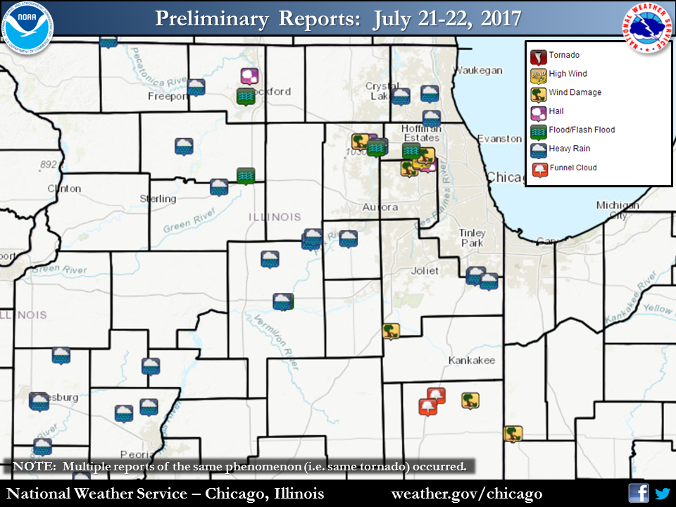 |
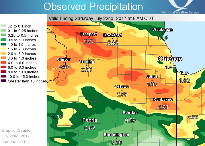
| July 21-22 Regional Rainfall | July 21-22 Local Rainfall | Storm Reports |
 |
 |
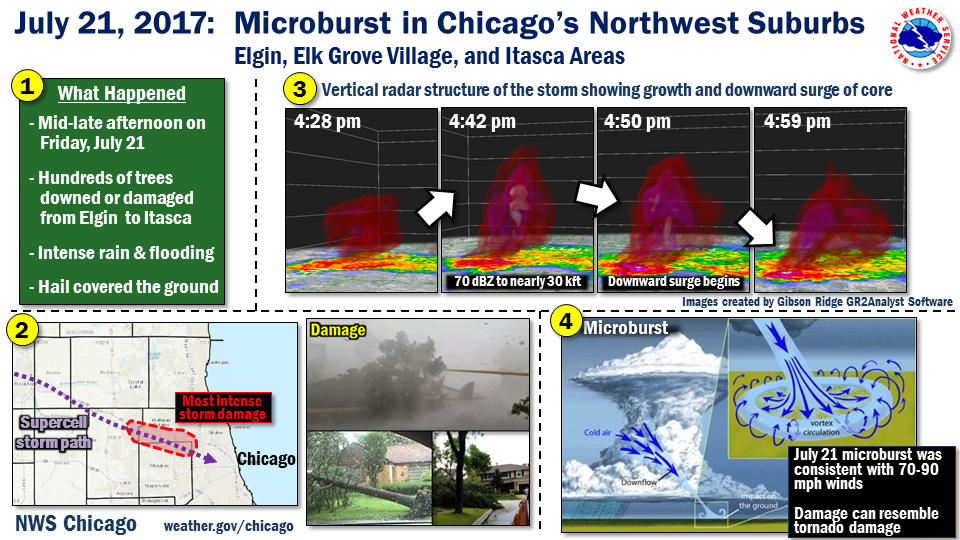
| July 21 Microburst in the Northwest Chicago Suburbs | July 21 Radar Loop of Microburst-Producing Storm |
 |
 |
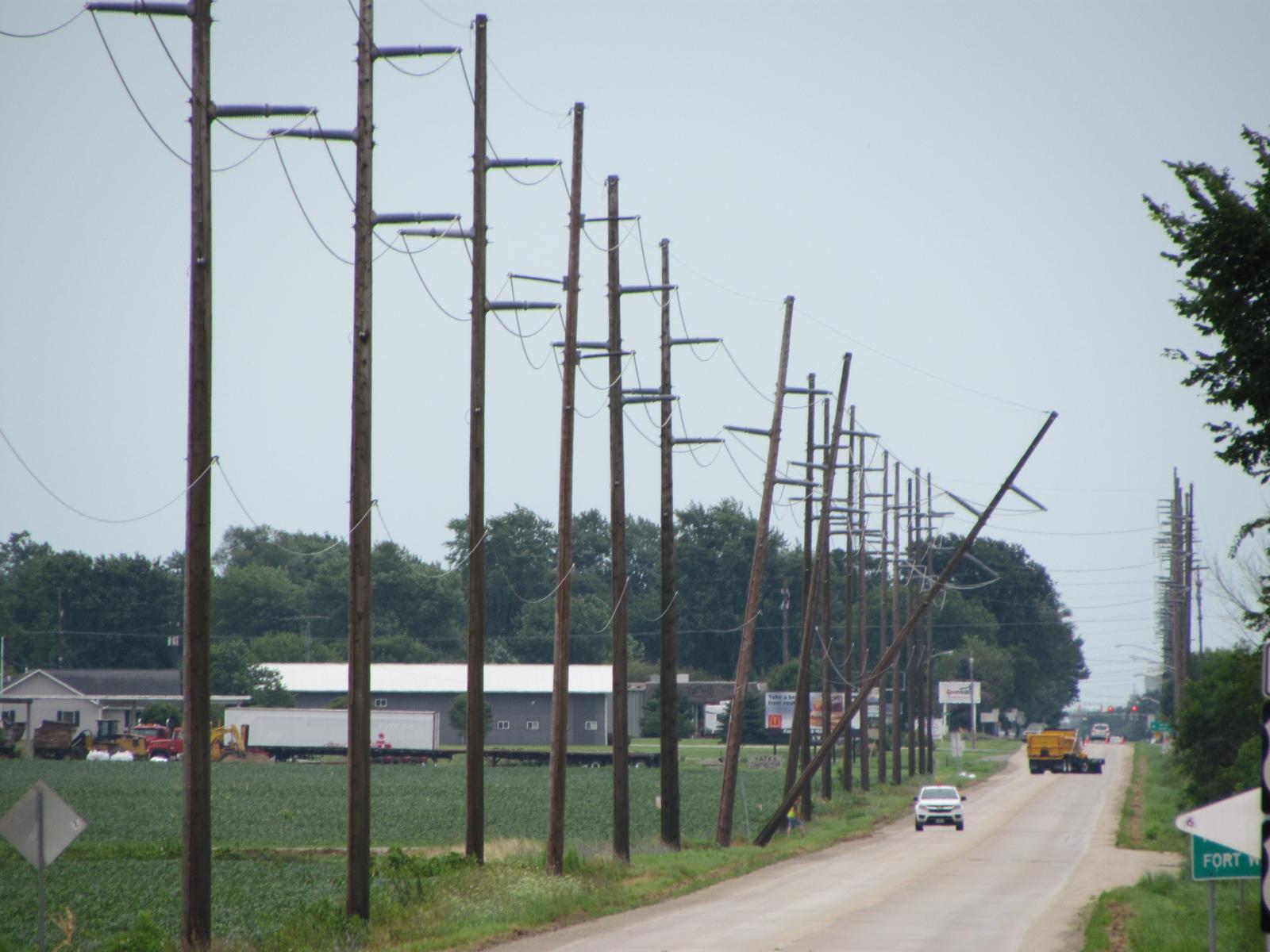 |
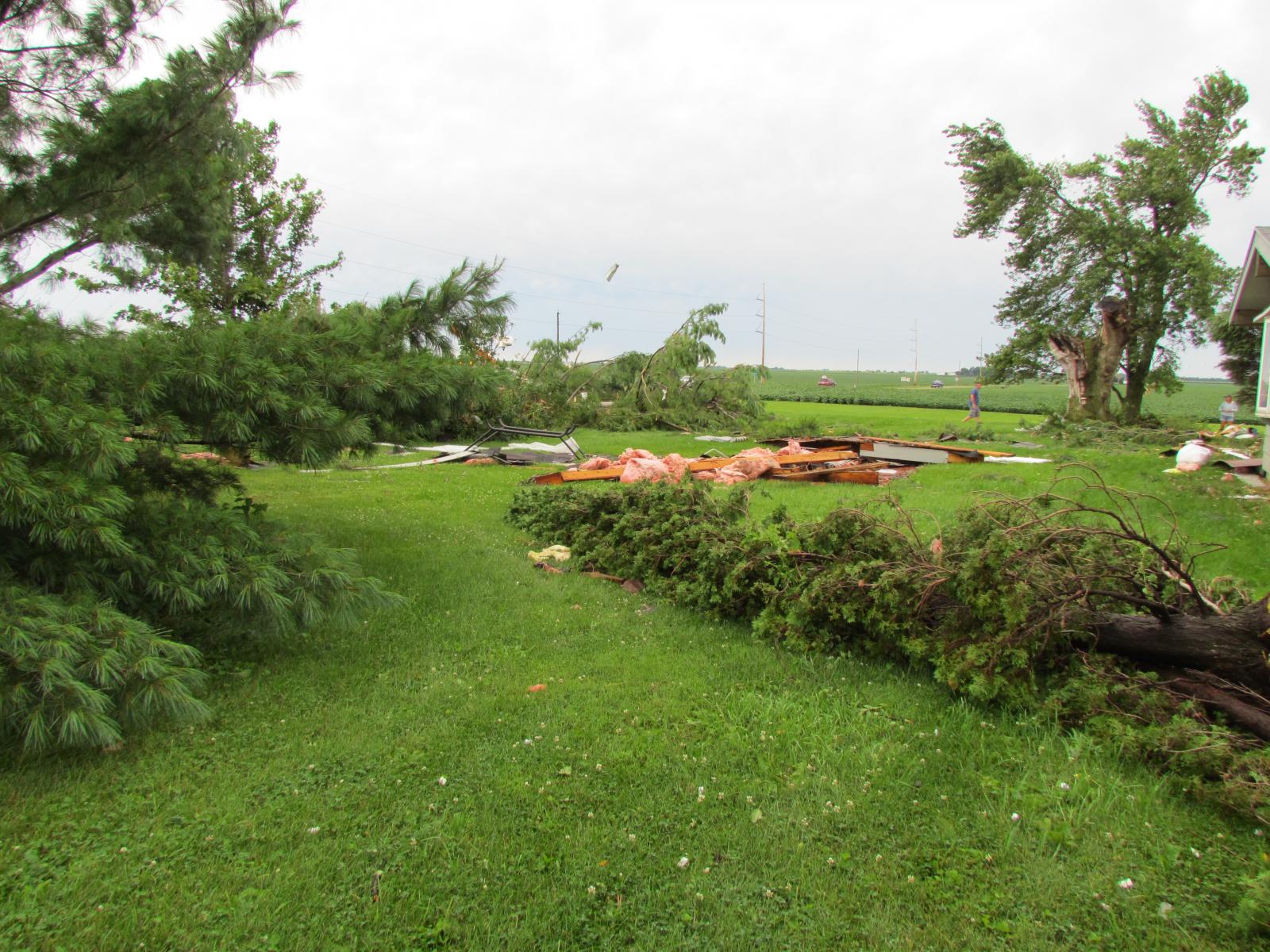
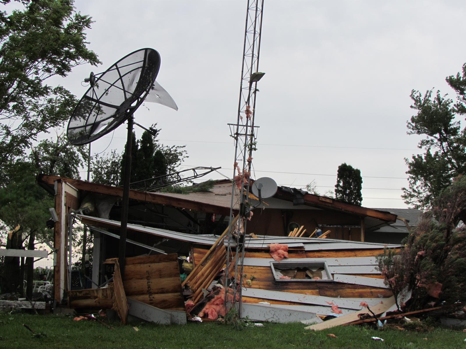
| Kentland, IN storm damage from the late night of July 21. Photos courtesy of Newton County, Indiana Emergency Management | ||
Rainfall
PUBLIC INFORMATION STATEMENT
NATIONAL WEATHER SERVICE CHICAGO IL
0922 AM CDT SAT JUL 22 2017

...MORNING RAINFALL ROUNDUP...

   THE FOLLOWING ARE RAIN AMOUNTS FOR THE PREVIOUS 24-HOURS
   AS MEASURED IN THE MORNING BY NWS COOPERATIVE OBSERVERS
   AND COCORAHS OBSERVERS.
   OBSERVATIONS ARE USUALLY TAKEN BETWEEN 6 AND 8 AM.

   24-HOUR RAINFALL AMOUNTS
       FOR SATURDAY(07/22/17)...


ILLINOIS                                       RAIN
  LOCATION (COUNTY):                           FALL (IN)

  PLANO (KENDALL)..............................4.65
  SOMONAUK 2NE (DE KALB).......................4.14
  CRETE 3E (WILL)..............................3.93
  SOMONAUK (DE KALB)...........................3.90
  MANTENO 2NW (KANKAKEE).......................3.89
  DIXON 3NNW (LEE).............................3.64
  OSWEGO 5SSE (KENDALL)........................3.62
  PEOTONE (WILL)...............................3.59
  HERSCHER 3E (KANKAKEE).......................3.42
  POLO (OGLE)..................................3.41
  BEECHER 3ENE (WILL)..........................3.33
  CARY (MCHENRY)...............................3.29
  ROCKFORD 3NE (WINNEBAGO).....................3.28
  ROCHELLE (OGLE)..............................3.10
  LOCKPORT 1SE (WILL)..........................3.03
  STERLING 4NE (LEE)...........................3.02
  MORRIS 2SSE (GRUNDY).........................2.87
  OTTAWA 1NW (LA SALLE)........................2.86
  LISBON 4NE (KENDALL).........................2.85
  SUBLETTE (LEE)...............................2.84
  ELGIN (KANE).................................2.83
  MENDOTA (LA SALLE)...........................2.78
  MANHATTAN 1ESE (WILL)........................2.77
  DIXON 2SW (LEE)..............................2.75
  PERU 1ENE (LA SALLE).........................2.74
  SENECA 1NNE (LA SALLE).......................2.73
  EARLVILLE 5NNE (DE KALB).....................2.71
  COAL CITY 3N (GRUNDY)........................2.68
  OTTAWA 2N (LA SALLE).........................2.68
  MORRIS 5NNW (GRUNDY).........................2.65
  PAW PAW (LEE)................................2.65
  NORTH UTICA 6N (LA SALLE)....................2.64
  MARSEILLES (LA SALLE)........................2.62
  LEMONT (COOK)................................2.58
  NEW LENOX 4SE (WILL).........................2.57
  MORRIS 6ESE (GRUNDY).........................2.55
  KANKAKEE 4WNW (KANKAKEE).....................2.55
  MORRIS (GRUNDY)..............................2.53
  LA SALLE (LA SALLE)..........................2.52
  ROCKFORD 1NW (WINNEBAGO).....................2.51
  MORRIS (GRUNDY)..............................2.51
  BOURBONNAIS (KANKAKEE).......................2.50
  ELWOOD 5NE (WILL)............................2.48
  NEW LENOX 3E (WILL)..........................2.47
  COAL CITY 4NNW (GRUNDY)......................2.43
  CARBON HILL 3.1N (GRUNDY)....................2.43
  PLAINFIELD 3SE (WILL)........................2.42
  WILMINGTON 6NW (WILL)........................2.42
  PLAINFIELD 5SW (KENDALL).....................2.41
  MANHATTAN (WILL).............................2.39
  JOLIET 2N (WILL).............................2.38
  BELVIDERE 2NW (BOONE)........................2.37
  WILMINGTON 3SE (WILL)........................2.37
  MENDOTA (LA SALLE)...........................2.36
  MANHATTAN 2SE (WILL).........................2.35
  JOLIET (WILL)................................2.35
  PALOS PARK 4WNW (COOK).......................2.31
  SLEEPY HOLLOW 1SE (KANE).....................2.31
  BONFIELD 4WSW (KANKAKEE).....................2.30
  NEW LENOX 2SE (WILL).........................2.30
  PARK FOREST (COOK)...........................2.30
  MONTGOMERY 1SSE (KENDALL)....................2.29
  CAPRON (BOONE)...............................2.28
  BYRON 3N (OGLE)..............................2.26
  COAL CITY (GRUNDY)...........................2.25
  HOMER GLEN 1ENE (WILL).......................2.24
  JOLIET LOCK/DAM (WILL).......................2.23
  MOKENA 1W (WILL).............................2.22
  ROCKFORD (WINNEBAGO).........................2.22
  ROMEOVILLE (WILL)............................2.21
  MUNDELEIN (LAKE).............................2.21
  ST ANNE (KANKAKEE)...........................2.21
  OTTAWA (LA SALLE)............................2.20
  ELK GROVE VILLAGE 2WSW (COOK)................2.19
  CRYSTAL LAKE 1WSW (MCHENRY)..................2.19
  STEWARD (LEE)................................2.19
  RIVERWOODS (LAKE)............................2.18
  PLAINFIELD 2SSE (WILL).......................2.18
  CHEBANSE (KANKAKEE)..........................2.16
  NAPERVILLE 4SSW (WILL).......................2.16
  BUFFALO GROVE 2N (LAKE)......................2.15
  PARK FOREST 1NNE (COOK)......................2.11
  GENOA (DE KALB)..............................2.09
  WILLOW SPRINGS (COOK)........................2.09
  OHARE (COOK).................................2.08
  OGLESBY 1ESE (LA SALLE)......................2.07
  PARK FOREST 1SW (COOK).......................2.04
  HARWOOD HEIGHTS (COOK).......................2.04
  ELGIN 2WNW (KANE)............................2.04
  ASHTON (LEE).................................2.03
  BULL VALLEY 2WNW (MCHENRY)...................2.03
  CHANNAHON 2SSE (WILL)........................2.03
  LAKE ZURICH (LAKE)...........................2.02
  HOMEWOOD (COOK)..............................2.00
  WAUCONDA 1W (LAKE)...........................2.00
  PERU (LA SALLE)..............................2.00
  CHICAGO RIDGE (COOK).........................1.98
  RAVENSWOOD MANOR (COOK)......................1.95
  ELGIN 1WSW (KANE)............................1.95
  MIDWAY COOP (COOK)...........................1.95
  FLOSSMOOR 1ESE (COOK)........................1.93
  PALOS PARK 1SW (COOK)........................1.90
  AURORA 4SE (DU PAGE).........................1.89
  MUNDELEIN 2WNW (LAKE)........................1.89
  CRYSTAL LAKE 5ENE (MCHENRY)..................1.87
  ROCHELLE (OGLE)..............................1.87
  OAK LAWN 2WNW (COOK).........................1.86
  CHICAGO 6NNE (COOK)..........................1.85
  CHICAGO 5NE (COOK)...........................1.85
  LANSING (COOK)...............................1.80
  HOFFMAN ESTATES 5W (COOK)....................1.80
  WOODSTOCK (MCHENRY)..........................1.79
  OAK LAWN (COOK)..............................1.77
  BURR RIDGE 2SW (DU PAGE).....................1.77
  BARRINGTON (LAKE)............................1.75
  DE KALB (DE KALB)............................1.75
  PALATINE 1NNE (COOK).........................1.74
  BANNOCKBURN (LAKE)...........................1.73
  WORTH (COOK).................................1.72
  PARK RIDGE 1WNW (COOK).......................1.71
  SUGAR GROVE 1NE (KANE).......................1.70
  SUGAR GROVE 1ENE (KANE)......................1.70
  NAPERVILLE 3SE (DU PAGE).....................1.69
  DWIGHT 4NNW (GRUNDY).........................1.68
  FLOSSMOOR (COOK).............................1.67
  ELGIN 2W (KANE)..............................1.67
  MIDWAY (COOK)................................1.65
  AURORA (KANE)................................1.60
  ROCKFORD 6S (WINNEBAGO)......................1.60
  CARPENTERSVILLE 1E (KANE)....................1.59
  WOODSTOCK 4SW (MCHENRY)......................1.59
  BRIDGEVIEW 1NNW (COOK).......................1.57
  ELK GROVE VILLAGE 1ESE (COOK)................1.57
  WONDER LAKE 1WNW (MCHENRY)...................1.57
  DE KALB 1SW (DE KALB)........................1.55
  MACHESNEY PARK 3ENE (WINNEBAGO)..............1.50
  OAK PARK 1NNE (COOK).........................1.49
  ROSCOE 2ESE (WINNEBAGO)......................1.48
  ROSCOE 2SE (WINNEBAGO).......................1.48
  WOODSTOCK 5NW (MCHENRY)......................1.48
  MIDLOTHIAN (COOK)............................1.46
  BATAVIA 1WSW (KANE)..........................1.46
  HIGHWOOD 1S (LAKE)...........................1.46
  ARLINGTON HEIGHTS 1SW (COOK).................1.45
  ARLINGTON HEIGHTS 3SSW (COOK)................1.45
  OAK LAWN 2SE (COOK)..........................1.44
  ROCKFORD (WINNEBAGO).........................1.43
  ALSIP (COOK).................................1.42
  MIDLOTHIAN (COOK)............................1.41
  BOTANIC GARDENS (COOK).......................1.40
  MIDLOTHIAN (COOK)............................1.40
  ALGONQUIN 1N (MCHENRY).......................1.40
  WINNEBAGO 1SE (WINNEBAGO)....................1.40
  STREATOR (LIVINGSTON)........................1.40
  PARK RIDGE (COOK)............................1.39
  LAKE IN THE HILLS 2.5W (MCHENRY).............1.39
  NORTH AURORA 2NE (KANE)......................1.38
  GENEVA 4WSW (KANE)...........................1.37
  MCHENRY (MCHENRY)............................1.37
  GLENCOE (COOK)...............................1.35
  LAKEMOOR 2SE (LAKE)..........................1.30
  KINGSTON 2WNW (DE KALB)......................1.29
  GENEVA 1SSW (KANE)...........................1.28
  STREATOR 1WSW (LA SALLE).....................1.28
  BATAVIA 1WNW (KANE)..........................1.26
  ST. CHARLES 6NW (KANE).......................1.25
  COUNTRYSIDE 1ENE (COOK)......................1.22
  LINCOLNWOOD 2E (COOK)........................1.22
  DEKALB (DE KALB).............................1.21
  CHICAGO 6ESE (COOK)..........................1.21
  LISLE (DU PAGE)..............................1.20
  ELBURN (KANE)................................1.20
  WESTMONT (DU PAGE)...........................1.20
  BATAVIA (KANE)...............................1.18
  CORTLAND (DE KALB)...........................1.18
  HEBRON (MCHENRY).............................1.16
  WHEELING (COOK)..............................1.16
  ELBURN (KANE)................................1.14
  BATAVIA 2WNW (KANE)..........................1.14
  ELBURN (KANE)................................1.14
  DWIGHT (LIVINGSTON)..........................1.13
  BURNHAM-HEGEWISCH 2NNW (COOK)................1.13
  WAUKEGAN 2E (LAKE)...........................1.06
  GLEN ELLYN 1WSW (DU PAGE)....................1.05
  DOWNERS GROVE 0.4NNE (DU PAGE)...............1.02
  WESTMONT 1SSW (DU PAGE)......................1.01
  GLEN ELLYN 2SSE (DU PAGE)....................1.01
  OAK PARK 2S (COOK)...........................1.00
  ST. CHARLES (KANE)...........................1.00
  WEST CHICAGO (DU PAGE).......................0.99
  LOMBARD 1NNW (DU PAGE).......................0.97
  WHEATON 2NNE (DU PAGE).......................0.96
  CAROL STREAM (DU PAGE).......................0.96
  OAK PARK 1SW (COOK)..........................0.95
  LAKE BLUFF 1W (LAKE).........................0.93
  BROOKFIELD (COOK)............................0.91
  CLIFTON 1NW (IROQUOIS).......................0.89
  ELMHURST 2SE (DU PAGE).......................0.87
  WAUKEGAN 2N (LAKE)...........................0.71
  ELMHURST (DU PAGE)...........................0.70
  ASHKUM 5.6E (IROQUOIS).......................0.61
  WAUKEGAN (LAKE)..............................0.54
  WATSEKA 6.9WNW (IROQUOIS)....................0.51
  ZION (LAKE)..................................0.50
  PONTIAC 1ESE (LIVINGSTON)....................0.36
  PONTIAC (LIVINGSTON).........................0.25
  PONTIAC 1SE (LIVINGSTON).....................0.22
  ROMEOVILLE (WILL)............................0.16
  CHATSWORTH (LIVINGSTON)......................0.15
  FAIRBURY (LIVINGSTON)........................0.06
  PAXTON (FORD)................................0.04
  BUCKLEY (IROQUOIS)...........................0.03

INDIANA                                        RAIN
  LOCATION (COUNTY):                           FALL (IN)

  ST. JOHN (LAKE)..............................4.47
  VALPARAISO 7WSW (PORTER).....................3.41
  CROWN POINT 2WSW (LAKE)......................3.28
  VALPARAISO 5WSW (PORTER).....................2.97
  WINFIELD 1NE (LAKE)..........................2.93
  DE MOTTE 1SSW (JASPER).......................2.90
  DE MOTTE 1NNW (JASPER).......................2.79
  SCHERERVILLE 1E (LAKE).......................2.70
  RENSSELAER (JASPER)..........................2.51
  DE MOTTE 4SW (JASPER)........................2.47
  RENSSELAER 5NW (JASPER)......................2.42
  HIGHLAND 1ESE (LAKE).........................2.31
  (W9MAL)MERRILLVILLE 2NNW (LAKE)..............2.20
  LAKE VILLAGE (NEWTON)........................2.17
  GRIFFITH 1N (LAKE)...........................2.10
  RENSSELAER 4N (JASPER).......................1.97
  DE MOTTE 6S (JASPER).........................1.90
  VALPARAISO 6NW (PORTER)......................1.84
  VALPARAISO 2WSW (PORTER).....................1.81
  RENSSELAER 2SSW (JASPER).....................1.77
  RENSSELAER 10NNE (JASPER)....................1.75
  MOROCCO (NEWTON).............................1.70
  RENSSELAER 8ENE (JASPER).....................1.68
  MUNSTER 2NNW (LAKE)..........................1.68
  PORTAGE 1ESE (PORTER)........................1.50
  PORTER 1S (PORTER)...........................1.48
  VALPARAISO 1SE (PORTER)......................1.43
  VALPARAISO 6WSW (PORTER).....................1.37
  (W9OPR)WHEATFIELD 1ENE (JASPER)..............1.35
  PORTAGE 3E (PORTER)..........................1.35
  VALPARAISO 1NNW (PORTER).....................1.32
  HEBRON 4NE (PORTER)..........................1.31
  KENTLAND (NEWTON)............................1.15
  VALPARAISO 1NE (PORTER)......................1.11
  KENTLAND 2SSE (NEWTON).......................1.07
  VALPARAISO 6SSW (PORTER).....................1.07
  REMINGTON (JASPER)...........................1.07
  VALPARAISO (PORTER)..........................1.02
  SCHNEIDER (LAKE).............................0.98
  REMINGTON (JASPER)...........................0.85

$$
Storm Reports
PRELIMINARY LOCAL STORM REPORT...SUMMARY
NATIONAL WEATHER SERVICE CHICAGO/ROMEOVILLE IL
526 AM CDT SAT JUL 22 2017

..TIME...   ...EVENT...      ...CITY LOCATION...     ...LAT.LON...
..DATE...   ....MAG....      ..COUNTY LOCATION..ST.. ...SOURCE....
            ..REMARKS..

0253 PM     TSTM WND DMG     ROCKFORD                42.27N 89.06W
07/21/2017                   WINNEBAGO          IL   LAW ENFORCEMENT

            NUMEROUS CALLS OF TREES AND POWERLINES DOWNED THROUGHOUT
            THE CITY

0300 PM     TSTM WND DMG     ROCKFORD                42.27N 89.06W
07/21/2017                   WINNEBAGO          IL   PUBLIC

            TWO TREES WERE KNOCKED DOWN IN ROCKFORD.

0310 PM     HAIL             MACHESNEY PARK          42.36N 89.04W
07/21/2017  E0.25 INCH       WINNEBAGO          IL   TRAINED SPOTTER

0310 PM     HAIL             MACHESNEY PARK          42.36N 89.04W
07/21/2017  E0.25 INCH       WINNEBAGO          IL   TRAINED SPOTTER

0332 PM     FLASH FLOOD      ROCKFORD                42.27N 89.06W
07/21/2017                   WINNEBAGO          IL   PUBLIC

            MULTIPLE STREETS IN ROCKFORD ARE IMPASSABLE DUE TO HEAVY
            RAINFALL.

0417 PM     HAIL             2 SSW SLEEPY HOLLOW     42.07N 88.33W
07/21/2017  E0.75 INCH       KANE               IL   STORM CHASER

0425 PM     HEAVY RAIN       1 NE ELGIN              42.05N 88.27W
07/21/2017  M1.33 INCH       KANE               IL   COCORAHS

            1.33 INCHES OF RAIN FELL IN 25 MINUTES.

0425 PM     TSTM WND GST     1 NE ELGIN              42.05N 88.27W
07/21/2017  E70.00 MPH       KANE               IL   COCORAHS

            ESTIMATED WIND GUST OF 70-80 MPH. HUNDREDS OF TREES
            DAMAGED ON THE EAST SIDE OF TOWN. SEVERAL ROADS CLOSED
            DUE TO FALLEN POWER LINES.

0425 PM     TSTM WND DMG     ELGIN                   42.04N 88.29W
07/21/2017                   KANE               IL   TRAINED SPOTTER

            TREES UPROOTED AND LARGER BRANCHES BROKEN OFF ONTO CARS.
            ESTIMATED WIND GUST AROUND 70 MPH.

0425 PM     TSTM WND DMG     2 E PINGREE GROVE       42.07N 88.38W
07/21/2017                   KANE               IL   TRAINED SPOTTER

            70 MPH WIND GUST AND DOWNED TREE BRANCHES AND POWERLINES
            NEAR PINGREE GROVE.

0425 PM     HAIL             2 E PINGREE GROVE       42.07N 88.38W
07/21/2017  E1.00 INCH       KANE               IL   TRAINED SPOTTER

            1 INCH HAIL WAS REPORTED NEAR PINGREE GROVE.

0449 PM     HAIL             SCHAUMBURG              42.03N 88.08W
07/21/2017  M1.25 INCH       COOK               IL   AMATEUR RADIO

            WINDS ESTIMATED AT 40-50 MPH.

0450 PM     HAIL             ELK GROVE VILLAGE       42.01N 87.99W
07/21/2017  M1.00 INCH       COOK               IL   PUBLIC

            QUARTER SIZED HAIL REPORTED IN ELK GROVE VILLAGE VIA
            FACEBOOK.

0453 PM     HAIL             ELK GROVE VILLAGE       42.01N 87.99W
07/21/2017  E1.00 INCH       COOK               IL   TRAINED SPOTTER

            LOTS OF ONE QUARTER INCH HAIL WITH A FEW QUARTER SIZED
            HAILSTONES.

0455 PM     HAIL             ITASCA                  41.98N 88.02W
07/21/2017  E1.25 INCH       DUPAGE             IL   TRAINED SPOTTER

0455 PM     TSTM WND DMG     ITASCA                  41.98N 88.02W
07/21/2017                   DUPAGE             IL   PUBLIC

            REPORTS OF TREES DOWN IN ITASCA VIA FACEBOOK.

0458 PM     HAIL             WOOD DALE               41.97N 87.98W
07/21/2017  E1.00 INCH       DUPAGE             IL   TRAINED SPOTTER

0458 PM     TSTM WND GST     1 N ITASCA              41.99N 88.02W
07/21/2017  M74.00 MPH       DUPAGE             IL   TRAINED SPOTTER

            MEASURED ON PERSONAL WEATHER STATION.

0500 PM     TSTM WND DMG     ELK GROVE VILLAGE       42.01N 87.99W
07/21/2017                   COOK               IL   TRAINED SPOTTER

            LARGE BRANCHES DOWN.

0500 PM     HAIL             ELK GROVE VILLAGE       42.01N 87.99W
07/21/2017  E1.25 INCH       COOK               IL   TRAINED SPOTTER

0816 PM     FUNNEL CLOUD     CLIFTON                 40.94N 87.93W
07/21/2017                   IROQUOIS           IL   LAW ENFORCEMENT

            FUNNEL CLOUD BRIEFLY REPORTED IN CLIFTON NEAR I-57 MILE
            MARK 297.

0828 PM     HEAVY RAIN       SSW ASHTON              41.87N 89.22W
07/21/2017  M0.67 INCH       LEE                IL   COCORAHS

            0.67 INCHES OF RAIN FELL IN 12 MINUTES.

0838 PM     FUNNEL CLOUD     5 N DANFORTH            40.89N 87.98W
07/21/2017                   IROQUOIS           IL   TRAINED SPOTTER

            FUNNEL CLOUD REPORTED FIVE MILES NORTH OF DANFORTH.

0906 PM     HEAVY RAIN       WAUCONDA                42.27N 88.14W
07/21/2017  M0.91 INCH       LAKE               IL   EMERGENCY MNGR

            0.91 INCHES REPORTED IN 30 MINUTES IN THE CITY OF
            WAUCONDA.

0942 PM     HEAVY RAIN       LIBERTYVILLE            42.28N 87.97W
07/21/2017  M1.01 INCH       LAKE               IL   EMERGENCY MNGR

            RAIN SO FAR THIS EVENING WITH 0.6 INCHES FALLING IN 10
            MINUTES.

0942 PM     HEAVY RAIN       SOMONAUK                41.63N 88.68W
07/21/2017  M3.10 INCH       DE KALB            IL   TRAINED SPOTTER

            RAINFALL TOTAL SO FAR TODAY WITH HEAVY RAIN FALLING AT
            REPORT TIME. RELAYED VIA TWITTER.

0946 PM     FLOOD            ROCHELLE                41.92N 89.06W
07/21/2017                   OGLE               IL   BROADCAST MEDIA

            INTERSECTION OF ROUTE 251 AND 10TH AVENUE FLOODED ALONG
            WITH MUCH OF 7TH STREET. STANDING WATER ON ROADS IN FLAGG
            CENTER.

1137 PM     FLOOD            1 NE OTTAWA             41.36N 88.83W
07/21/2017                   LA SALLE           IL   TRAINED SPOTTER

            ABOUT 5 INCHES OF STANDING WATER COVERING THE ROAD ALONG
            ROUTE 6 WEST OF THE FOX RIVER IN OTTAWA.

1200 AM     HEAVY RAIN       YORKVILLE               41.64N 88.45W
07/22/2017  M2.48 INCH       KENDALL            IL   CO-OP OBSERVER

            TOTAL RAINFALL SINCE 7 PM FRIDAY.

1215 AM     TSTM WND DMG     MARTINTON               40.92N 87.73W
07/22/2017                   IROQUOIS           IL   EMERGENCY MNGR

            TWO HOMES ON SOUTHWEST CORNER OF TOWN NEAR ROUTE 1 WITH
            ROOF DAMAGE...INCLUDING ONE WITH PARTIAL ROOF LOSS. ALSO
            DOWNED POWER POLES IN AREA. TIME ESTIMATED BY RADAR.

1236 AM     TSTM WND DMG     2 W KENTLAND            40.77N 87.48W
07/22/2017                   NEWTON             IN   LAW ENFORCEMENT

            ON A PROPERTY NEAR INTERSECTION OF ROUTE 52 AND STATE
            ROAD 71...MULTIPLE TREES DOWN...PARTIAL STRUCTURAL
            COLLAPSE AND ROOF REMOVED ON A POLE BARN.

1236 AM     TSTM WND DMG     1 W KENTLAND            40.77N 87.47W
07/22/2017                   NEWTON             IN   LAW ENFORCEMENT

            POWER POLE DOWN.


&&

$$
July 23
 |
 |
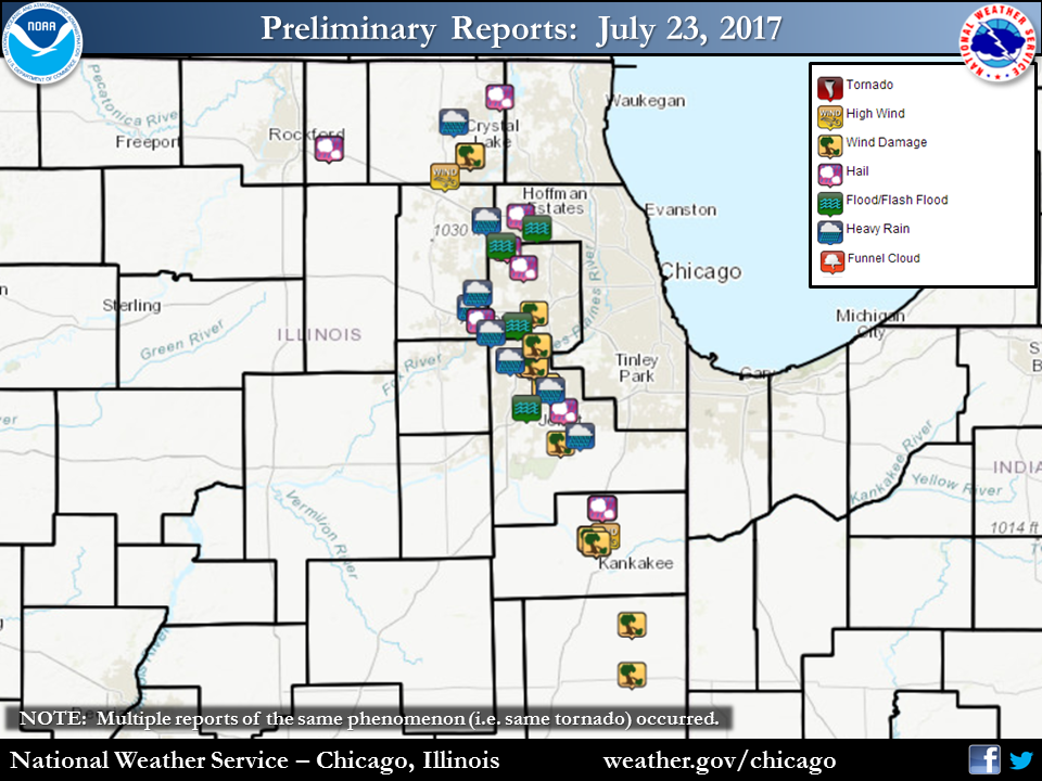 |
| July 23 Radar Loop | Rainfall | Storm Reports |
 |
 |
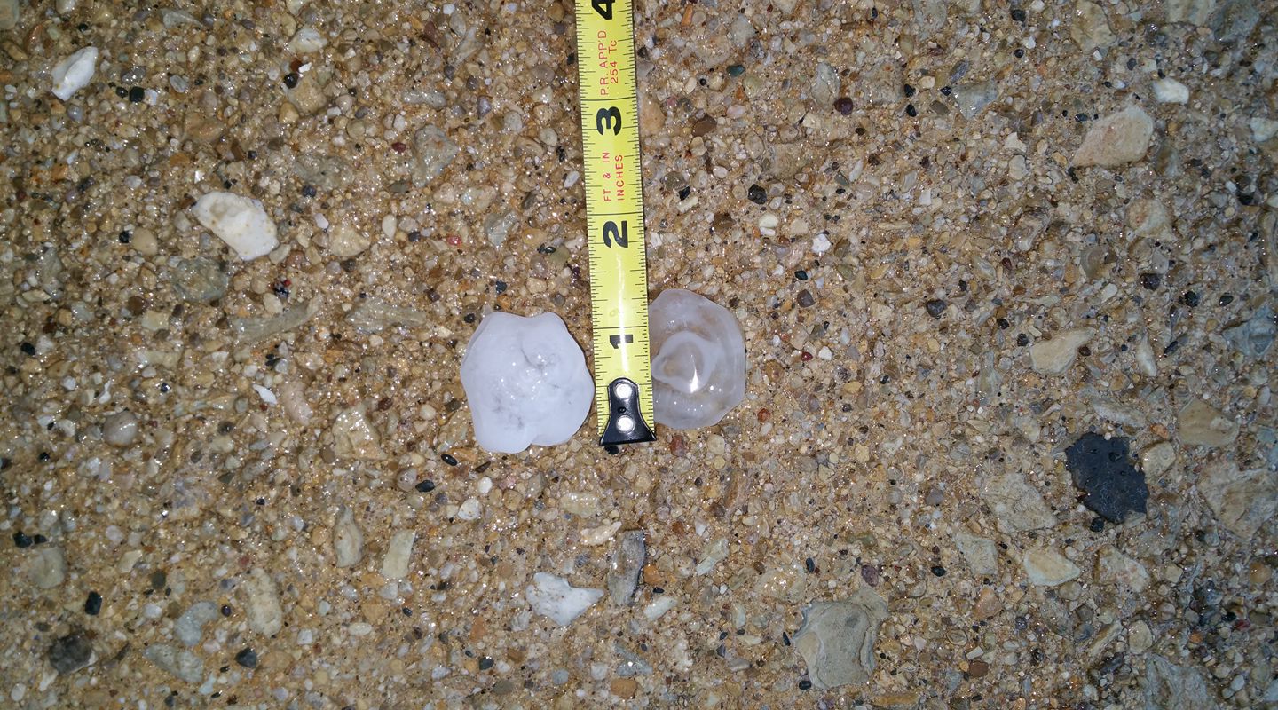
| Hail from Aurora, IL, courtesy of Keith Wagner | From Manteno, IL, courtesy of Sean M. Baxter |
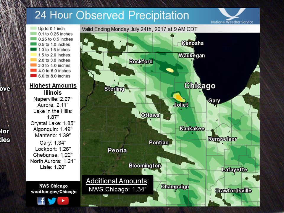
Rainfall
Public Information Statement
National Weather Service Chicago IL
1021 AM CDT Mon Jul 24 2017

...Morning Rainfall Roundup...Update

   The following are rain amounts for the previous 24-hours
   as measured in the morning by NWS Cooperative Observers
   and CoCoRaHS observers.
   Observations are usually taken between 6 AND 8 AM.

   24-hour rainfall amounts
       for Monday(07/24/17)...


Illinois                                       Rain
  Location (County):                           fall (inches)

  Naperville 4SSW (Will).......................2.27
  Aurora 4SE (Du Page).........................2.11
  Aurora 4SE (Du Page).........................2.10
  Naperville 2SE (Du Page).....................2.07
  Naperville 2ESE (Du Page)....................1.89
  Lake in the Hills 2.5W (McHenry).............1.87
  Crystal Lake 1WSW (McHenry)..................1.85
  Aurora (Kane)................................1.76
  Naperville 2ESE (Du Page)....................1.73
  Aurora 4NE (Du Page).........................1.62
  Naperville 3SE (Du Page).....................1.55
  Algonquin 1N (McHenry).......................1.49
  Manteno 2SSE (Kankakee)......................1.39
  Cary (McHenry)...............................1.34
  Lockport 1SE (Will)..........................1.26
  Romeoville (Will)............................1.25
  Cary (McHenry)...............................1.23
  Chebanse (Kankakee)..........................1.22
  North Aurora 2NE (Kane)......................1.21
  Lisle (Du Page)..............................1.20
  Capron (Boone)...............................1.16
  Manhattan 1ESE (Will)........................1.14
  Lisle Morton Arb (Du Page)...................1.11
  Bull Valley 2WNW (McHenry)...................1.10
  Elgin 1WSW (Kane)............................1.09
  Elgin 2WNW (Kane)............................1.07
  Woodstock 4SW (McHenry)......................1.06
  Manhattan 2SE (Will).........................1.06
  Mundelein (Lake).............................1.06
  Lemont (Cook)................................1.05
  Lisle 1SE (Du Page)..........................1.05
  New Lenox 3ENE (Will)........................1.05
  Batavia (Kane)...............................1.01
  Manhattan 5ENE (Will)........................1.00
  Woodstock 1SSW (McHenry).....................0.98
  Woodstock 5nw (McHenry)......................0.97
  Manhattan (Will).............................0.95
  Geneva 4WSW (Kane)...........................0.94
  Joliet Lock/dam (Will).......................0.93
  Elgin (Kane).................................0.90
  Carpentersville 1E (Kane)....................0.90
  Plainfield (Will)............................0.89
  Downers Grove 0.4NNE (Du Page)...............0.85
  Hebron (McHenry).............................0.84
  Geneva 1SSW (Kane)...........................0.82
  New Lenox 3E (Will)..........................0.82
  New Lenox 2SE (Will).........................0.81
  Barrington (Lake)............................0.78
  Glen Ellyn 2SSE (Du Page)....................0.78
  Elgin 2W (Kane)..............................0.78
  Wonder Lake 1WNW (McHenry)...................0.76
  Elk Grove Village 2WSW (Cook)................0.75
  Montgomery 1SSE (Kendall)....................0.75
  Sleepy Hollow 1SE (Kane).....................0.73
  Batavia 1WNW (Kane)..........................0.73
  New Lenox 4SE (Will).........................0.71
  Joliet (Will)................................0.71
  Batavia 2WNW (Kane)..........................0.70
  Joliet 2n (Will).............................0.69
  Gilberts (Kane)..............................0.65
  Herscher 3E (Kankakee).......................0.64
  Hoffman Estates 5W (Cook)....................0.62
  Glen Ellyn 1WSW (Du Page)....................0.62
  Palos Park 4WNW (Cook).......................0.61
  Wonder Lake 1NE (McHenry)....................0.61
  Homer Glen 1ENE (Will).......................0.61
  Westmont (Du Page)...........................0.61
  Lake Villa 1SSW (Lake).......................0.59
  Homer Glen 2NW (Will)........................0.59
  Kingston 2WNW (De Kalb)......................0.58
  Westmont 1SSW (Du Page)......................0.57
  Carol Stream (Du Page).......................0.57
  Bonfield 4WSW (Kankakee).....................0.57
  Lake Zurich 1N (Lake)........................0.57
  Glen Ellyn 1NNW (Du Page)....................0.56
  Streamwood (Cook)............................0.53
  Elgin 8WSW (Kane)............................0.52
  St Anne (Kankakee)...........................0.51
  West Chicago (Du Page).......................0.50
  Belvidere 2NW (Boone)........................0.50
  Sugar Grove 1NE (Kane).......................0.50
  Lakemoor 2SE (Lake)..........................0.50
  Crystal Lake 5ENE (McHenry)..................0.49
  Roselle 1ESE (Du Page).......................0.46
  Bourbonnais (Kankakee).......................0.45
  Wheaton 2NNE (Du Page).......................0.45
  St. Charles 6NW (Kane).......................0.45
  Burr Ridge 2SW (Du Page).....................0.43
  Sugar Grove 1ENE (Kane)......................0.43
  Lily Lake 2E (Kane)..........................0.43
  Peotone (Will)...............................0.43
  Lake Villa 2WSW (Lake).......................0.42
  Schaumburg 2E (Cook).........................0.41
  Mundelein 2WNW (Lake)........................0.41
  Wilmington 3SE (Will)........................0.39
  Harvard (McHenry)............................0.38
  Clifton 1NW (Iroquois).......................0.37
  Kankakee 4WNW (Kankakee).....................0.37
  Palos Park 1SW (Cook)........................0.36
  Watseka 6.9WNW (Iroquois)....................0.36
  Gurnee 2W (Lake).............................0.36
  Lake Zurich (Lake)...........................0.36
  Momence 6SSW (Kankakee)......................0.35
  Lincolnshire 1N (Lake).......................0.34
  Buffalo Grove 2N (Lake)......................0.34
  Genoa (De Kalb)..............................0.33
  Roscoe 2ESE (Winnebago)......................0.33
  Roscoe 2se (Winnebago).......................0.33
  Paxton (Ford)................................0.32
  Channahon 2SSE (Will)........................0.31
  Rockford 2ENE (Winnebago)....................0.31
  Cropsey 1NE (Livingston).....................0.30
  Arlington Heights 3SSW (Cook)................0.29
  Arlington Heights 1SW (Cook).................0.28
  Cortland (De Kalb)...........................0.27
  Gibson 6NE (Ford)............................0.27
  Monee (Will).................................0.24
  Midlothian 1SE (Cook)........................0.23
  Mazon 0.5ENE (Grundy)........................0.23
  Plainfield 3SE (Will)........................0.23
  Dekalb (De Kalb).............................0.22
  Palatine 1NNE (Cook).........................0.22
  Countryside 1ENE (Cook)......................0.21
  Lombard 1NNW (Du Page).......................0.21
  Ohare (Cook).................................0.21
  Elburn (Kane)................................0.20
  De Kalb (De Kalb)............................0.19
  Brookfield (Cook)............................0.19
  Fox Lake 2SE (Lake)..........................0.19
  Elmhurst (Du Page)...........................0.18
  Ashkum 5.6E (Iroquois).......................0.18
  Rockford 3NE (Winnebago).....................0.18
  Elburn (Kane)................................0.17
  Oak Park 2S (Cook)...........................0.17
  De Kalb (De Kalb)............................0.17
  Elburn (Kane)................................0.17
  Elk Grove Village 1ESE (Cook)................0.16
  Midlothian (Cook)............................0.15
  De Kalb 1SW (De Kalb)........................0.15
  Riverwoods (Lake)............................0.15
  Oak Park 1SW (Cook)..........................0.14
  Oswego 5SSE (Kendall)........................0.14
  Rockford 1NW (Winnebago).....................0.14
  Midlothian (Cook)............................0.13
  Gibson 3WNW (Ford)...........................0.12
  Wheeling (Cook)..............................0.12
  Aurora (Kane)................................0.11
  Bridgeview 1NNW (Cook).......................0.11
  Park Ridge 1WNW (Cook).......................0.11
  Park Forest 1SW (Cook).......................0.11
  Homewood (Cook)..............................0.11
  Earlville 5NNE (De Kalb).....................0.11
  Seneca 2SSW (La Salle).......................0.11
  Plainfield 2SSE (Will).......................0.11
  Park Forest (Cook)...........................0.11
  Flossmoor (Cook).............................0.10
  Park Ridge (Cook)............................0.10
  Flossmoor 1ESE (Cook)........................0.10
  Morris 6ESE (Grundy).........................0.10
  Paw Paw (Lee)................................0.10
  Dwight 4NNW (Grundy).........................0.09
  Rockford (Winnebago).........................0.09
  Chicago Ridge (Cook).........................0.08
  Worth (Cook).................................0.08
  Lake Forest 2NNE (Lake)......................0.08
  Midway Coop (Cook)...........................0.08
  Chicago 6ESE (Cook)..........................0.07
  Oak Lawn 2WNW (Cook).........................0.07
  Oak Park 1NNE (Cook).........................0.07
  Coal City (Grundy)...........................0.07
  Channahon 1NNE (Will)........................0.07
  Alsip (Cook).................................0.06
  Coal City 4NNW (Grundy)......................0.05
  Carbon Hill 3.1N (Grundy)....................0.05
  Oak Lawn 2SE (Cook)..........................0.04
  Oak Lawn (Cook)..............................0.04
  Winthrop Harbor 1SSW (Lake)..................0.04
  Beecher 3SSE (Will)..........................0.04
  Coal City 3N (Grundy)........................0.03
  Dixon 3NNW (Lee).............................0.03
  Crete 3E (Will)..............................0.03
  South Beloit 2SE (Winnebago).................0.03
  Midway (Cook)................................0.03
  Waukegan (Lake)..............................0.03
  Plainfield 5SW (Kendall).....................0.02
  Highwood 1S (Lake)...........................0.02
  Waukegan 2E (Lake)...........................0.02
  Beecher 3ENE (Will)..........................0.02
  Rochelle (Ogle)..............................0.02
  Yorkville 2SE (Kendall)......................0.02
  Morris (Grundy)..............................0.01
  Lincolnwood 2E (Cook)........................0.01
  Winnebago 1SE (Winnebago)....................0.01
  Steward (Lee)................................0.01
  Botanic Gardens (Cook)......................TRACE
  Morris 2SSE (Grundy)........................TRACE
  Wilmington 6NW (Will).......................TRACE
  Lansing (Cook)..............................TRACE

Indiana                                        Rain
  Location (County):                           fall (inches)

  Kentland (Newton)............................0.53
  Porter 1S (Porter)...........................0.34
  Kentland 2SSE (Newton).......................0.30
  Crown Point (Lake)...........................0.12
  Crown Point 1N (Lake)........................0.12
  Schererville 1E (Lake).......................0.12
  Valparaiso 6SSW (Porter).....................0.12
  Rensselaer 4N (Jasper).......................0.10
  Morocco (Newton).............................0.10
  Rensselaer 8ENE (Jasper).....................0.09
  Valparaiso 6WSW (Porter).....................0.09
  Valparaiso 4SW (Porter)......................0.08
  Hebron 4NE (Porter)..........................0.07
  Remington (Jasper)...........................0.06
  De Motte 6S (Jasper).........................0.05
  Winfield 1NE (Lake)..........................0.04
  Crown Point 2WSW (Lake)......................0.03
  St. John (Lake)..............................0.03
  Munster 2NNW (Lake)..........................0.03
  Portage 3E (Porter)..........................0.03
  Rensselaer 10NNE (Jasper)....................0.02
  Valparaiso (Porter)..........................0.02
  Dyer 1WNW (Lake).............................0.01
  Valparaiso 2NW (Porter)......................0.01
  Wheatfield 3S (Jasper)......................TRACE
  Valparaiso 2WSW (Porter)....................TRACE
  Portage 1ESE (Porter).......................TRACE
  Valparaiso 6NW (Porter).....................TRACE
  Lake Village (Newton).......................TRACE

$$
Storm Reports
PRELIMINARY LOCAL STORM REPORT...SUMMARY
NATIONAL WEATHER SERVICE CHICAGO/ROMEOVILLE IL
200 AM CDT MON JUL 24 2017

..TIME...   ...EVENT...      ...CITY LOCATION...     ...LAT.LON...
..DATE...   ....MAG....      ..COUNTY LOCATION..ST.. ...SOURCE....
            ..REMARKS..

0216 PM     HAIL             3 SW FOX LAKE           42.39N 88.22W
07/23/2017  E0.75 INCH       MCHENRY            IL   PUBLIC

0329 PM     TSTM WND GST     CRYSTAL LAKE            42.23N 88.33W
07/23/2017  M56.00 MPH       MCHENRY            IL   AMATEUR RADIO

            MEASURED 56 MPH WIND GUST ALONG WITH PEA SIZE HAIL

0331 PM     TSTM WND DMG     CRYSTAL LAKE            42.23N 88.33W
07/23/2017                   MCHENRY            IL   PUBLIC

            THREE FOOT DIAMETER TREE DOWNED.

0345 PM     HAIL             BELVIDERE               42.25N 88.85W
07/23/2017  M1.00 INCH       BOONE              IL   PUBLIC

            MULTIPLE QUARTER SIZE HAIL REPORTS FROM SOCIAL MEDIA

0349 PM     HAIL             BELVIDERE               42.25N 88.85W
07/23/2017  E1.00 INCH       BOONE              IL   PUBLIC

            HALF INCH TO INCH HAIL. REPORT RELAYED BY ROCKFORD MEDIA.


0404 PM     HAIL             HOFFMAN ESTATES         42.06N 88.14W
07/23/2017  E0.88 INCH       COOK               IL   TRAINED SPOTTER

            PENNY TO NICKEL SIZE HAIL AND HEAVY RAIN

0407 PM     NON-TSTM WND GST HUNTLEY                 42.17N 88.42W
07/23/2017  E55.00 MPH       MCHENRY            IL   AMATEUR RADIO

            ESTIMATED 55 MPH WIND GUST AND PEA SIZE HAIL

0427 PM     HEAVY RAIN       1 NE ELGIN              42.05N 88.27W
07/23/2017  M0.66 INCH       KANE               IL   COCORAHS

            0.66 INCHES OF RAIN IN 20 MINUTES. SEVERAL ROADS HAVE
            STANDING WATER. HALF INCH DIAMETER HAIL WAS ALSO
            OBSERVED.

0434 PM     HAIL             1 SE BARTLETT           41.97N 88.19W
07/23/2017  M1.00 INCH       DUPAGE             IL   COCORAHS

            MULTIPLE REPORTS OF NICKEL TO QUARTER SIZE HAIL

0435 PM     HEAVY RAIN       1 NE NORTH AURORA       41.81N 88.32W
07/23/2017  M0.71 INCH       KANE               IL   COCORAHS

            0.71 INCHES IN 15 MINUTES

0438 PM     HEAVY RAIN       BATAVIA                 41.85N 88.30W
07/23/2017  E0.50 INCH       KANE               IL   CO-OP OBSERVER

            OVER HALF AN INCH OF RAIN IN 10 MINUTES. PEA SIZED HAIL
            WAS ALSO OBSERVED.

0439 PM     FLOOD            SCHAUMBURG              42.03N 88.08W
07/23/2017                   COOK               IL   TRAINED SPOTTER

            6-12 INCHES OF WATER ON SCHAUMBURG ROAD BETWEEN BRAINTREE
            DR AND ROSELLE ROAD. ONE CAR WAS STALLED IN THE WATER.

0442 PM     FLOOD            BARTLETT                41.98N 88.21W
07/23/2017                   DUPAGE             IL   TRAINED SPOTTER

            4-12 INCHES OF STANDING WATER ON RT 59

0446 PM     HAIL             CAROL STREAM            41.92N 88.13W
07/23/2017  M1.00 INCH       DUPAGE             IL   PUBLIC

            REPORT FROM SOCIAL MEDIA

0452 PM     HAIL             AURORA                  41.77N 88.29W
07/23/2017  M1.00 INCH       KANE               IL   TRAINED SPOTTER

            MULTIPLE REPORTS OF NICKEL TO QUARTER SIZE HAIL

0453 PM     HAIL             AURORA                  41.77N 88.29W
07/23/2017  M1.50 INCH       KANE               IL   TRAINED SPOTTER

            1.5 TO 1.25 INCH HAIL

0458 PM     TSTM WND DMG     LISLE                   41.79N 88.09W
07/23/2017                   DUPAGE             IL   TRAINED SPOTTER

            1 DIAMETER TREE BRANCHES BLOWN DOWN

0508 PM     HAIL             1 N ROMEOVILLE          41.66N 88.09W
07/23/2017  M1.00 INCH       WILL               IL   NWS EMPLOYEE

0508 PM     TSTM WND GST     1 N ROMEOVILLE          41.66N 88.09W
07/23/2017  E60.00 MPH       WILL               IL   NWS EMPLOYEE

0510 PM     TSTM WND DMG     1 N ROMEOVILLE          41.66N 88.09W
07/23/2017                   WILL               IL   NWS EMPLOYEE

            TWO NORTHSIDE WINDOWS BLOWN OUT AND SHINGLES PEELED AT AN
            APARTMENT COMPLEX. SOME SHINGLES DETACHED COMPLETELY.
            NUMEROUS LARGE BRANCHES DOWN THROUGHOUT TOWN.

0510 PM     TSTM WND DMG     1 W ROMEOVILLE          41.65N 88.11W
07/23/2017                   WILL               IL   NWS EMPLOYEE

            PIECES OF ROOFING BLOWN OFF A STRIP MALL

0513 PM     TSTM WND DMG     ROMEOVILLE              41.65N 88.09W
07/23/2017                   WILL               IL   PUBLIC

            METAL POOL FENCE BLOWN OFF A POOL AND A YOUNG 2 INCH
            DIAMETER TREE WAS UPROOTED.

0514 PM     TSTM WND DMG     LOCKPORT                41.59N 88.05W
07/23/2017                   WILL               IL   NWS EMPLOYEE

            8 INCH DIAMETER TREE BRANCH DOWN. TIME ESTIMATED.

0514 PM     TSTM WND DMG     LOCKPORT                41.59N 88.05W
07/23/2017                   WILL               IL   PUBLIC

            LARGE PART OF ROOF BLOWN OFF A BUILDING.

0518 PM     FLOOD            NAPERVILLE              41.76N 88.15W
07/23/2017                   DUPAGE             IL   NWS EMPLOYEE

            STANDING WATER ON WASHINGTON STREET AT GARNER ROAD. WATER
            WAS ABOVE WHEELS OF CARS.

0519 PM     TSTM WND DMG     ROMEOVILLE              41.65N 88.09W
07/23/2017                   WILL               IL   TRAINED SPOTTER

            SEVERAL 6+ INCH DIAMETER TREE LIMBS BLOWN DOWN ON LEWIS
            UNIVERSITY CAMPUS.

0520 PM     HEAVY RAIN       3 NNE PLAINFIELD        41.66N 88.18W
07/23/2017  M0.94 INCH       WILL               IL   COCORAHS

            0.94 INCHES OF RAIN IN 20 MINUTES. HIGH WINDS REMOVED
            SIDING FROM HOUSES AS WELL. STANDING WATER IN STREETS AND
            FIELDS.

0530 PM     HEAVY RAIN       3 SE AURORA             41.74N 88.25W
07/23/2017  M2.11 INCH       DUPAGE             IL   COCORAHS

            2.11 INCHES OF RAIN FELL IN 45 MINUTES.

0535 PM     FLOOD            BOLINGBROOK             41.70N 88.08W
07/23/2017                   WILL               IL   NWS EMPLOYEE

            STANDING WATER ON BROOKWOOD LANE OFF OF BOUGHTON

0539 PM     HAIL             NEW LENOX               41.52N 87.98W
07/23/2017  E0.50 INCH       WILL               IL   TRAINED SPOTTER

0554 PM     TSTM WND DMG     MANHATTAN               41.43N 87.99W
07/23/2017                   WILL               IL   PUBLIC

            TREE OF AROUND TWO FOOT IN DIAMETER DOWNED.

0557 PM     TSTM WND DMG     BOLINGBROOK             41.70N 88.08W
07/23/2017                   WILL               IL   NWS EMPLOYEE

            NUMEROUS TREE BRANCHES AND LIMBS DOWN ON BROOKWOOD LANE
            OFF OF BOUGHTON. SOME LIMBS AS LARGE AS 1 FOOT IN
            DIAMETER.

0612 PM     TSTM WND DMG     MANTENO                 41.25N 87.84W
07/23/2017                   KANKAKEE           IL   TRAINED SPOTTER

            NUMEROUS LARGE TREES AND TREE BRANCHES DOWN. GARBAGE CAN
            CARRIED 20-25 FT.

0615 PM     HEAVY RAIN       1 SE LOCKPORT           41.58N 88.03W
07/23/2017  M1.16 INCH       WILL               IL   COCORAHS

            1.16 INCHES OF RAIN FELL IN 45 MINUTES. MINOR FLOODING
            REPORTED.

0615 PM     HEAVY RAIN       4 ENE MANHATTAN         41.45N 87.92W
07/23/2017  M0.95 INCH       WILL               IL   COCORAHS

            0.95 INCHES FELL IN 30 MINUTES

0619 PM     FLOOD            JOLIET                  41.53N 88.12W
07/23/2017                   WILL               IL   TRAINED SPOTTER

            7-8 INCHES OF STANDING WATER ON INFANTRY DRIVE ON THE
            WEST SIDE OF JOLIET. STANDING WATER IS FROM CURB TO CURB
            ACROSS THE STREET.

0619 PM     TSTM WND GST     BOURBONNAIS             41.16N 87.88W
07/23/2017  M51.00 MPH       KANKAKEE           IL   AMATEUR RADIO

0622 PM     HAIL             BOURBONNAIS             41.16N 87.88W
07/23/2017  M1.00 INCH       KANKAKEE           IL   TRAINED SPOTTER

0624 PM     HAIL             MANTENO                 41.25N 87.84W
07/23/2017  M1.00 INCH       KANKAKEE           IL   TRAINED SPOTTER

0624 PM     TSTM WND DMG     MANTENO                 41.25N 87.84W
07/23/2017                   KANKAKEE           IL   EMERGENCY MNGR

            ABOUT 10 POWER POLES SNAPPED. NEAR THE INTERSECTION OF
            7000N AND 1000W A BARN ROOF WAS BLOWN OFF.

0627 PM     TSTM WND GST     BRADLEY                 41.15N 87.86W
07/23/2017  E60.00 MPH       KANKAKEE           IL   AMATEUR RADIO

            ESTIMATED 60-70 MPH WITH EXTENSIVE TREE DAMAGE IN BRADLEY


0628 PM     TSTM WND GST     3 E BOURBONNAIS         41.17N 87.83W
07/23/2017  M72.00 MPH       KANKAKEE           IL   MESONET

0629 PM     TSTM WND DMG     BOURBONNAIS             41.16N 87.88W
07/23/2017                   KANKAKEE           IL   TRAINED SPOTTER

            NUMEROUS TREES AND TREE LIMBS DOWN ALONG ST. GEORGE ROAD
            BLOCKING THE ROAD. CROP DAMAGE AND HALF INCH DIAMETER
            HAIL WERE ALSO REPORTED.

0630 PM     TSTM WND DMG     BRADLEY                 41.15N 87.86W
07/23/2017                   KANKAKEE           IL   PUBLIC

            LARGE TREE LIMB AROUND TWO FEET IN DIAMETER SNAPPED OFF.

0714 PM     TSTM WND DMG     WATSEKA                 40.78N 87.73W
07/23/2017                   IROQUOIS           IL   EMERGENCY MNGR

            MULTIPLE POWER POLES DOWN.


&&

$$
Meteorology
 |
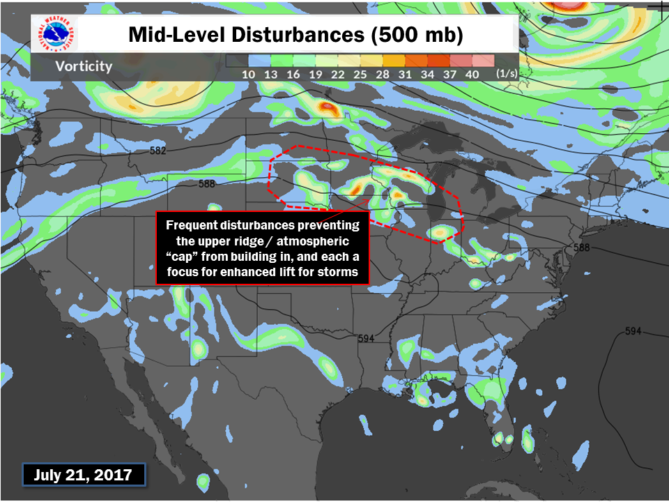 |
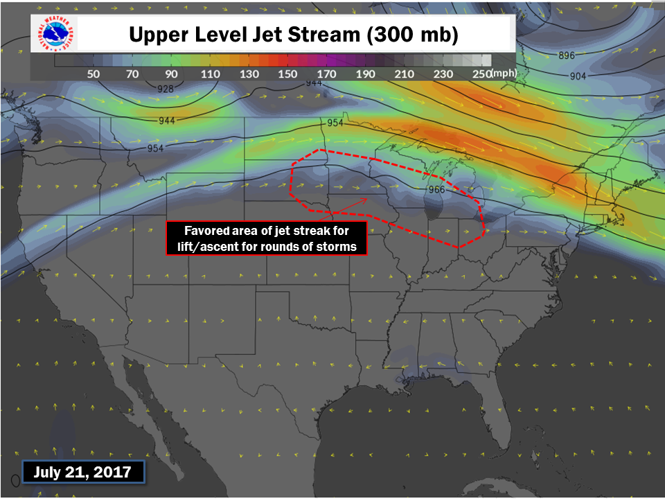
| Upper Level Winds | Mid-Level Forcing |
 |
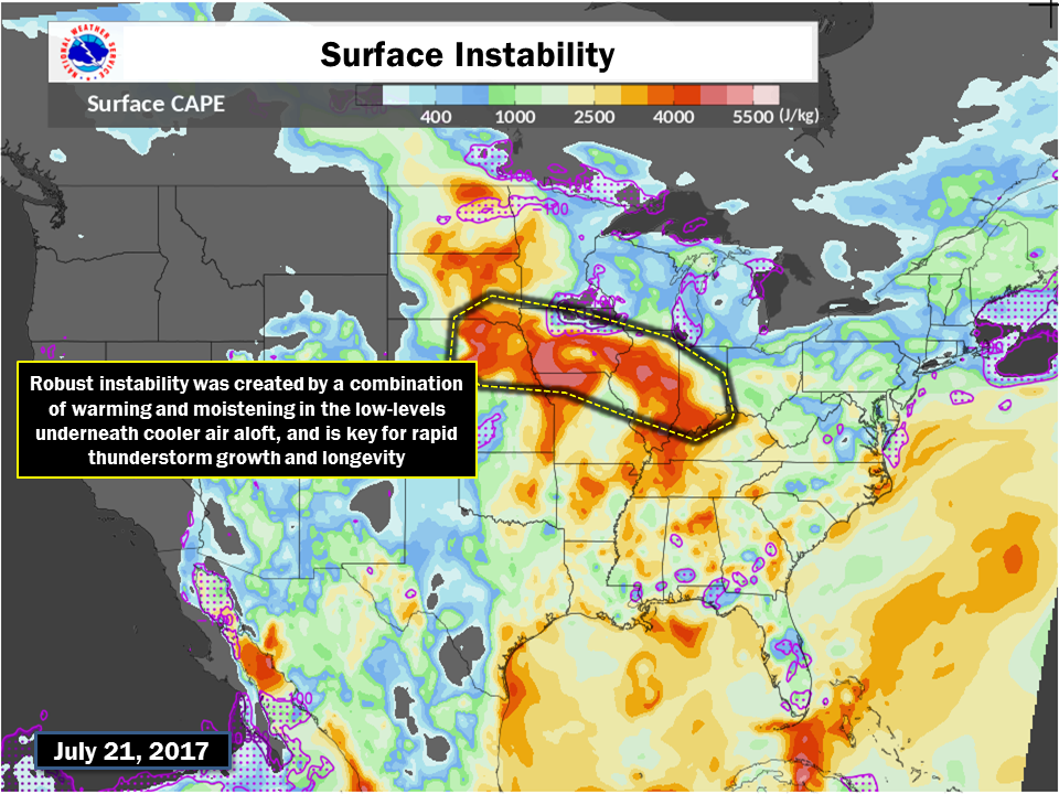 |
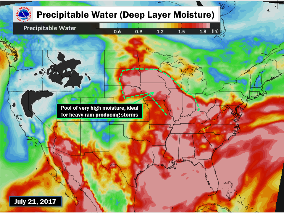
| Moisture | Instability |
Additional Info
 |
Media use of NWS Web News Stories is encouraged! Please acknowledge the NWS as the source of any news information accessed from this site. Additional recaps can be found on the NWS Chicago Past Events Page |
|

