Widespread life-threatening flash and urban flooding continues in south-central Texas, with considerable flooding impacts possible across central Texas. Wildfire smoke is impacting air quality across much of the Great Lakes region into southern New England and the Mid-Atlantic. Monsoonal thunderstorms may produce isolated to scattered flash flooding across the Southwest into the Great Basin. Read More >
Overview
|
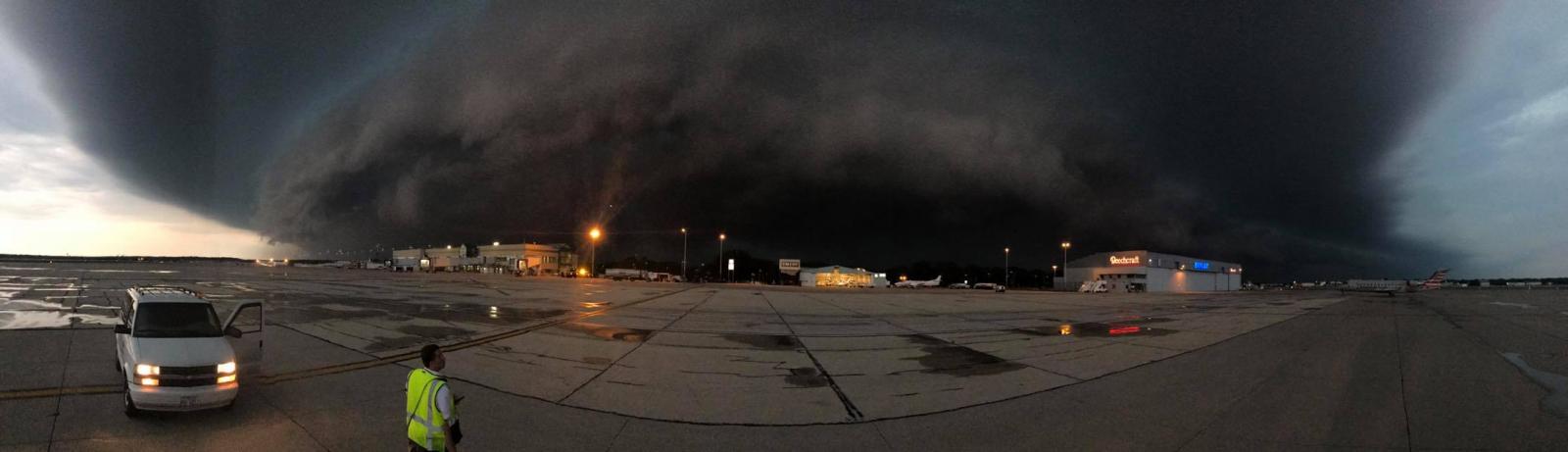
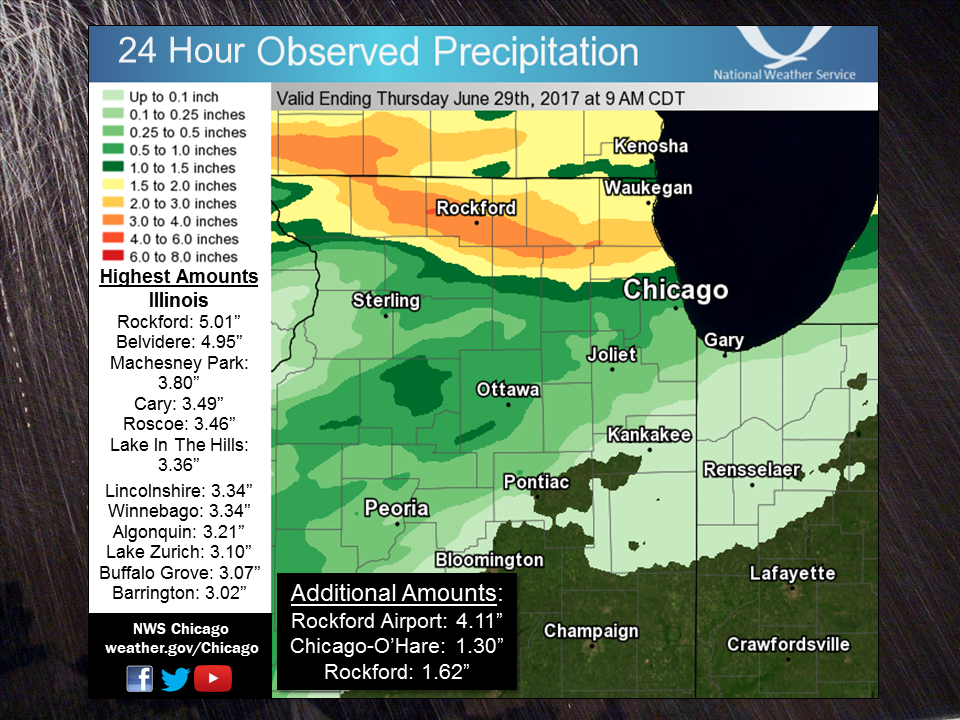
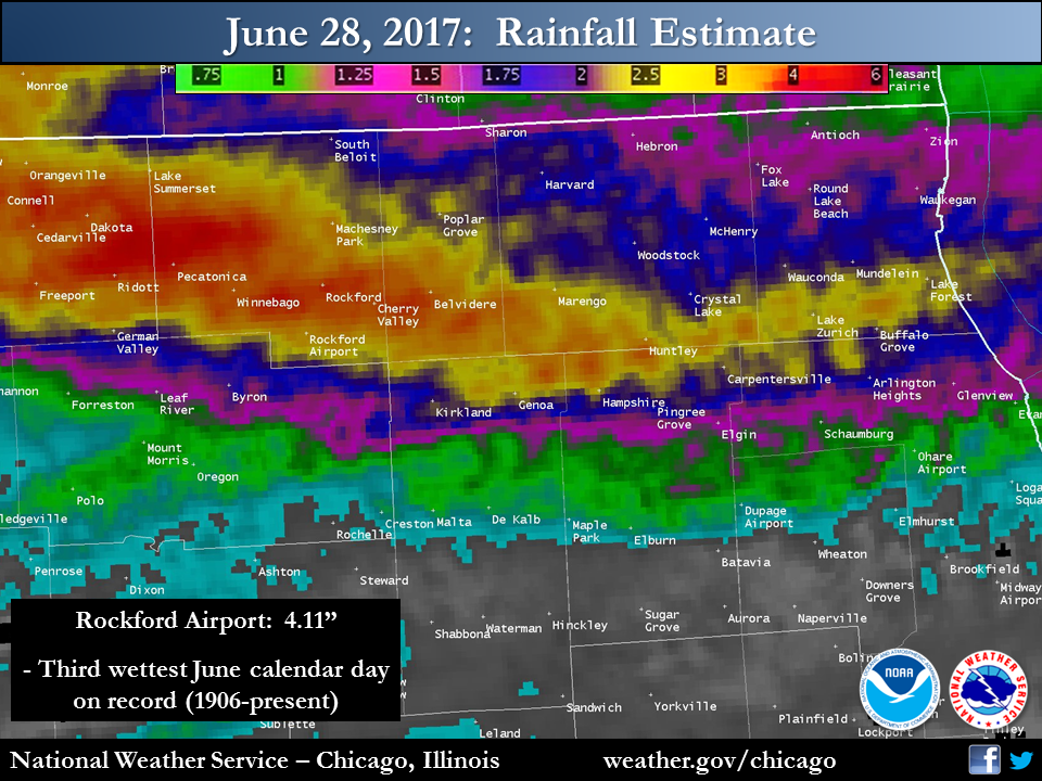
Wednesday evening, June 28, saw strong to severe storms redevelop and track across far northern Illinois. Some of the initial storms were supercells, producing a couple of EF-1 tornadoes over north central Illinois in Winnebago and Boone Counties. There were also areas of straight-line wind damage, including into Lake County Illinois. The main story though was the significant flash flooding in Winnebago and Boone Counties due to 3 to 6+ inches of rain, mainly in less than four hours. The flash flooding was extreme enough to cause dozens of roads to be flooded and impassable across the two counties, include parts of the cities of Rockford and Belvidere. There were reports from Emergency Management of numerous vehicles stranded and drivers having to be rescued, as well as creeks over their banks including Kent Creek in Rockford. Prior to the event, the NWS had been noting potential for heavy rain in Weather Story graphics for a few days in advance, and had issued a Flash Flood watch early Wednesday evening. This was shortly followed by a Flash Flood Warning at 8:24 p.m., updated to a Flash Flood Emergency at 9:32 p.m. given the flooding magnitude. |
|
Tornadoes:
|
Tornado - Cherry Valley to Belvidere
Track Map 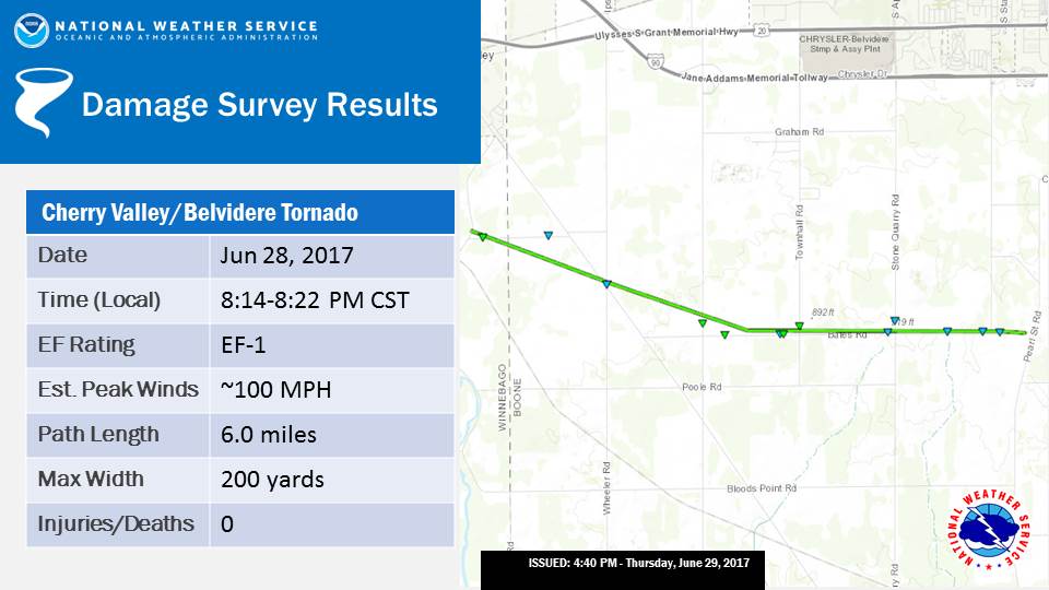 
|
||||||||||||||||
|
Tornado - Belvidere
Track Map 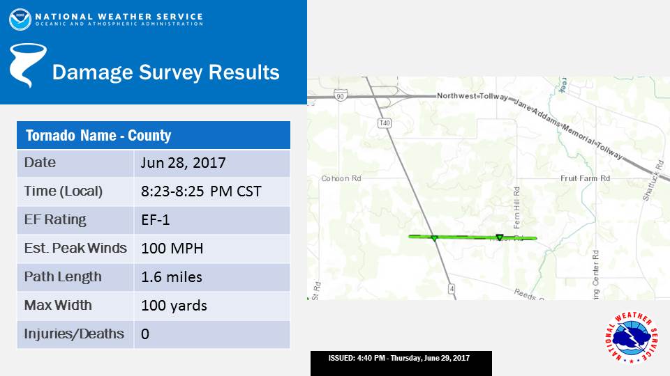
|
||||||||||||||||
The Enhanced Fujita (EF) Scale classifies tornadoes into the following categories:
| EF0 Weak 65-85 mph |
EF1 Moderate 86-110 mph |
EF2 Significant 111-135 mph |
EF3 Severe 136-165 mph |
EF4 Extreme 166-200 mph |
EF5 Catastrophic 200+ mph |
 |
|||||
Storm Reports
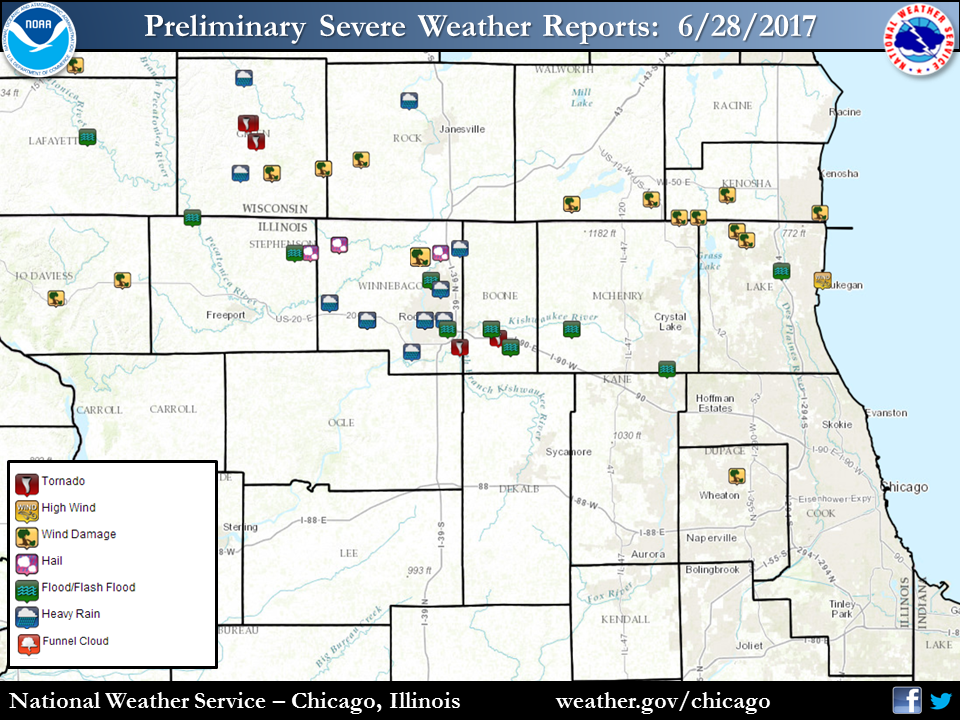 |
| Storm Reports |
PRELIMINARY LOCAL STORM REPORT...SUMMARY
NATIONAL WEATHER SERVICE CHICAGO/ROMEOVILLE IL
1128 PM CDT THU JUN 29 2017

..TIME...   ...EVENT...      ...CITY LOCATION...     ...LAT.LON...
..DATE...   ....MAG....      ..COUNTY LOCATION..ST.. ...SOURCE....
            ..REMARKS..

0740 PM     TSTM WND DMG     DURAND                  42.44N 89.33W
06/28/2017                   WINNEBAGO          IL   PUBLIC

            5 TREES AND NUMEROUS TREE BRANCHES REPORTED DOWN. 3
            INCHES OF RAINFALL REPORTED IN 2 HOURS. REPORT FROM
            SOCIAL MEDIA.

0759 PM     TSTM WND DMG     MACHESNEY PARK          42.36N 89.04W
06/28/2017                   WINNEBAGO          IL   PUBLIC

            NUMEROUS TREE BRANCHES DOWN AND 1 FT DIAMETER TREE
            UPROOTED. CEMENTED FLAG POLE ALSO BENT FROM WIND GUST

0800 PM     TSTM WND GST     WINNEBAGO               42.27N 89.24W
06/28/2017  E60.00 MPH       WINNEBAGO          IL   PUBLIC

            TORRENTIAL RAINFALL AND WIND, ESTIMATED GUST GREATER THAN
            60 MPH

0806 PM     TSTM WND DMG     MACHESNEY PARK          42.36N 89.04W
06/28/2017                   WINNEBAGO          IL   BROADCAST MEDIA

            PART OF HOUSE ROOF BLOWN OFF.

0810 PM     TSTM WND DMG     ROCKFORD                42.27N 89.06W
06/28/2017                   WINNEBAGO          IL   TRAINED SPOTTER

            8 DIAMETER TREE LIMBS, POWER LINES ON 11TH STREET NEAR
            SANDY HOLLOW

0810 PM     FLOOD            WINNEBAGO               42.27N 89.24W
06/28/2017                   WINNEBAGO          IL   TRAINED SPOTTER

            5 INCHES OF FLOWING WATER OBSERVED ON NORTH ELIDA NEAR
            EAST RUNYARD

0814 PM     TORNADO          2 SSE CHERRY VALLEY     42.21N 88.95W
06/28/2017                   WINNEBAGO          IL   NWS STORM SURVEY

            EF-1 TORNADO MAX WINDS AROUND 100 MPH TOUCHED DOWN NEAR
            BURTON RD AND RIVER RD SOUTH OF CHERRY VALLEY AND
            CONTINUED EAST AND SOUTHEAST EVENTUALLY LIFTING NEAR
            BATES AND TRIPP RD. THE TORNADO WAS ON THE GROUND FOR 6.0
            MILES BETWEEN 814 PM CDT AND 822 PM CDT

0820 PM     FLOOD            WINNEBAGO               42.27N 89.24W
06/28/2017                   WINNEBAGO          IL   TRAINED SPOTTER

            STREET FLOODING IN WINNEBAGO, 4-6 INCHES OF FLOWING WATER
            COVERING ROADWAYS

0823 PM     TORNADO          2 SSE BELVIDERE         42.23N 88.83W
06/28/2017                   BOONE              IL   NWS STORM SURVEY

            AN EF-1 TORNADO WITH MAX WINDS AROUND 100 MPH TOUCHED
            DOWN WEST OF THE INTERSECTION OF HUBER AND GENOA RD AND
            LIFTED EAST OF THE INTERSECTION OF HUBER AND FERN HILL
            RD. THE TORNADO WAS ON THE GROUND FOR 1.6 MILES BETWEEN
            823 PM CDT AND 825 PM CDT

0825 PM     FLASH FLOOD      BELVIDERE               42.25N 88.85W
06/28/2017                   BOONE              IL   EMERGENCY MNGR

            EAST ROAD BETWEEN 4TH AND 8TH IS CLOSED DUE TO FLASH
            FLOODING

0835 PM     FUNNEL CLOUD     MARENGO                 42.25N 88.60W
06/28/2017                   MCHENRY            IL   LAW ENFORCEMENT

            OBSERVED BY MARENGO POLICE.

0840 PM     FLOOD            ROCKFORD                42.27N 89.06W
06/28/2017                   WINNEBAGO          IL   TRAINED SPOTTER

            SPOTTER MEASURED 6 INCHES OF STANDING WATER

0845 PM     TSTM WND DMG     ANTIOCH                 42.47N 88.08W
06/28/2017                   LAKE               IL   EMERGENCY MNGR

            NUMEROUS TREES AND LARGE TREE BRANCHES DOWNED, LIKELY DUE
            TO A CONCENTRATED MICROBURST.

0846 PM     TSTM WND DMG     2 SE ANTIOCH            42.45N 88.05W
06/28/2017                   LAKE               IL   PUBLIC

            TREES DOWN IN THE EAST LOON LAKE AREA.

0910 PM     TSTM WND GST     5 SSE BEACH PARK        42.36N 87.81W
06/28/2017  M52.00 MPH       LMZ740             IL   C-MAN STATION

            45 KT.

0930 PM     FLOOD            GURNEE                  42.38N 87.94W
06/28/2017                   LAKE               IL   TRAINED SPOTTER

            1.05 INCHES OF RAIN HAD FALLEN BY 930

0930 PM     FLASH FLOOD      ROCKFORD                42.27N 89.06W
06/28/2017                   WINNEBAGO          IL   EMERGENCY MNGR

            REPORTS OF NUMEROUS CARS STRANDED ON FLOODED ROADWAYS
            ESPECIALLY NEAR ROCKFORD VIADUCTS. KENT CREEK IS ALSO OUT
            OF ITS BANKS.

1000 PM     HEAVY RAIN       ROCKFORD                42.27N 89.06W
06/28/2017  M5.48 INCH       WINNEBAGO          IL   PUBLIC

            5.48 INCHES MEASURED AT ROCKFORD INTERNATIONAL GOLF
            COURSE. 3.48 INCHES MEASURED IN DOWNTOWN ROCKFORD. REPORT
            FROM SOCIAL MEDIA.

1000 PM     HEAVY RAIN       LOVES PARK              42.34N 89.01W
06/28/2017  M5.69 INCH       WINNEBAGO          IL   PUBLIC

            REPORT FROM SOCIAL MEDIA.

1000 PM     FLASH FLOOD      LOVES PARK              42.34N 89.01W
06/28/2017                   WINNEBAGO          IL   EMERGENCY MNGR

            NUMEROUS RESIDENTIAL ROADS IMPASSABLE DUE TO WATER.

1000 PM     FLASH FLOOD      MACHESNEY PARK          42.36N 89.04W
06/28/2017                   WINNEBAGO          IL   EMERGENCY MNGR

            NUMEROUS RESIDENTIAL ROADS IMPASSABLE DUE TO WATER.

1000 PM     FLASH FLOOD      ROCKFORD                42.27N 89.06W
06/28/2017                   WINNEBAGO          IL   EMERGENCY MNGR

            PEAK OF WATER RESCUES FROM STALLED VEHICLES DUE TO FLASH
            FLOODING IN THE CITY. NUMEROUS ROADS IMPASSABLE DUE TO
            WATER.

1000 PM     FLASH FLOOD      PECATONICA              42.31N 89.36W
06/28/2017                   WINNEBAGO          IL   EMERGENCY MNGR

            NUMEROUS RESIDENTIAL ROADS IMPASSABLE DUE TO WATER.

1000 PM     FLASH FLOOD      4 ESE ROCKFORD          42.25N 88.99W
06/28/2017                   WINNEBAGO          IL   EMERGENCY MNGR

            WATER ACROSS A PARKING LOT AT A PHARMACY. CARS STRANDED
            AND PEOPLE TEMPORARILY UNABLE TO LEAVE THE BUILDING.

1000 PM     HEAVY RAIN       ROCKFORD                42.27N 89.06W
06/28/2017  M2.37 INCH       WINNEBAGO          IL   OFFICIAL NWS OBS

            2 HOUR AMOUNT AND STILL RAINING.

1000 PM     HEAVY RAIN       WINNEBAGO               42.27N 89.24W
06/28/2017  M5.21 INCH       WINNEBAGO          IL   PUBLIC

            REPORT FROM SOCIAL MEDIA.

1008 PM     HEAVY RAIN       PECATONICA              42.31N 89.36W
06/28/2017  M5.00 INCH       WINNEBAGO          IL   TRAINED SPOTTER

            STORM TOTAL SO FAR. DITCHES ON FULL.

1030 PM     FLASH FLOOD      MARENGO                 42.25N 88.60W
06/28/2017                   MCHENRY            IL   LAW ENFORCEMENT

            WATER OVER PART OF ILLINOIS ROUTE 23.

1035 PM     HEAVY RAIN       ROCKFORD                42.27N 89.06W
06/28/2017  M4.25 INCH       WINNEBAGO          IL   TRAINED SPOTTER

            0.45 ICHES OF RAIN FELL THIS MORNING WITH AN ADDITIONAL
            3.80 INCHES THIS EVENING

1100 PM     FLASH FLOOD      BELVIDERE               42.25N 88.85W
06/28/2017                   BOONE              IL   LAW ENFORCEMENT

            SIGNIFICANT FLOODING ON MANY ROADWAYS IN BELIVDERE WHERE
            THERE WERE WATER RESCUES FROM STRANDED VEHICLES. NUMEROUS
            ROADS CLOSED DUE TO FLOODING THROUGHOUT THE COUNTY.

1100 PM     FLASH FLOOD      ALGONQUIN               42.16N 88.30W
06/28/2017                   MCHENRY            IL   LAW ENFORCEMENT

            ALGONQUIN ROAD IMPASSABLE DUE TO WATER.

1140 PM     TSTM WND DMG     GLENDALE HEIGHTS        41.92N 88.08W
06/28/2017                   DUPAGE             IL   PUBLIC

            SEVERAL POWERLINES DOWN AND A FEW SMALL TREES DOWN.
            SUSPECTED MICROBURST. TIME ESTIMATED FROM RADAR.

1200 AM     HEAVY RAIN       ROCKFORD AIRPORT        42.20N 89.10W
06/29/2017  M4.11 INCH       WINNEBAGO          IL   OFFICIAL NWS OBS

            DAILY TOTAL MOST OF WHICH FELL IN THE EVENING.

1200 AM     HEAVY RAIN       3 ENE ROSCOE            42.43N 88.95W
06/29/2017  M2.67 INCH       WINNEBAGO          IL   TRAINED SPOTTER

1255 AM     NON-TSTM WND GST PONTIAC                 40.88N 88.64W
06/29/2017  M61.00 MPH       LIVINGSTON         IL   AWOS

            DUE TO A WAKE LOW.

0130 AM     FLASH FLOOD      4 SE BELVIDERE          42.21N 88.79W
06/29/2017                   BOONE              IL   BROADCAST MEDIA

            DITCHES OVERFLOWED AND WATER ONTO GENOA ROAD.
Rain Reports
 |
 |
| Observed rainfall from NWS Coop & Cooperative Observers. | Radar Estimated Rainfall |
The 4.11" at Rockford was a daily record for the day, and the third highest calendar day rainfall amount for June on record. For more, see here.
Public Information Statement
National Weather Service Chicago IL
1021 AM CDT Thu Jun 29 2017

...Morning Rainfall Roundup...

   The following are rain amounts for the previous 24-hours
   as measured in the morning by NWS Cooperative Observers
   and CoCoRaHS observers.
   Observations are usually taken between 6 AND 8 AM.

   24-hour rainfall amounts
       for Thursday(06/29/17)...


Illinois                                       Rain
  Location (County):                           fall (inches)

  Rockford 2ENE (Winnebago)....................5.01
  Belvidere 2NW (Boone)........................4.95
  Rockford 1NW (Winnebago).....................4.88
  Belvidere (Boone)............................4.70
  Rockford 3NE (Winnebago).....................4.30
  Rockford (Winnebago).........................4.11
  Rockford 6S (Winnebago)......................3.93
  Machesney Park 3ENE (Winnebago)..............3.80
  Cary (McHenry)...............................3.49
  Roscoe 2ESE (Winnebago)......................3.46
  Roscoe 2se (Winnebago).......................3.46
  Lake In The Hills 1ESE (McHenry).............3.36
  Lincolnshire 1N (Lake).......................3.34
  Winnebago 1SE (Winnebago)....................3.34
  Algonquin 1N (McHenry).......................3.21
  Cary (McHenry)...............................3.17
  Lake Zurich 1N (Lake)........................3.10
  Buffalo Grove 2N (Lake)......................3.07
  Lake in the Hills 2.5W (McHenry).............3.05
  Lake Zurich (Lake)...........................3.04
  Barrington (Lake)............................3.02
  Crystal Lake 1WSW (McHenry)..................2.91
  Bannockburn (Lake)...........................2.82
  Woodstock 4SW (McHenry)......................2.77
  Highwood 1S (Lake)...........................2.76
  Kingston 2WNW (De Kalb)......................2.75
  Palatine 1NNE (Cook).........................2.69
  Woodstock 5nw (McHenry)......................2.69
  Crystal Lake (McHenry).......................2.68
  Riverwoods (Lake)............................2.67
  Lake Forest 2NNE (Lake)......................2.57
  Mundelein (Lake).............................2.57
  Bull Valley 2WNW (McHenry)...................2.52
  Carpentersville 1E (Kane)....................2.51
  Harvard 3SSE (McHenry).......................2.50
  Botanic Gardens (Cook).......................2.46
  Libertyville 2ESE (Lake).....................2.39
  Lake Bluff 1W (Lake).........................2.38
  Palatine 1E (Cook)...........................2.37
  Gilberts (Kane)..............................2.36
  Winnetka 1ESE (Cook).........................2.32
  Capron (Boone)...............................2.30
  Crystal Lake 5ENE (McHenry)..................2.29
  South Beloit 2SE (Winnebago).................2.29
  Mundelein 2WNW (Lake)........................2.27
  Woodstock 1SSW (McHenry).....................2.27
  Byron 3N (Ogle)..............................2.27
  Mundelein (Lake).............................2.23
  Elgin (Kane).................................2.18
  Wheeling (Cook)..............................2.15
  Wonder Lake 1WNW (McHenry)...................2.14
  Arlington Heights 1SW (Cook).................2.13
  Mchenry (McHenry)............................2.13
  Glencoe (Cook)...............................2.12
  Lakemoor 2SE (Lake)..........................2.05
  Elgin 2NE (Kane).............................1.96
  Mount Prospect 3NE (Cook)....................1.95
  Hoffman Estates 5W (Cook)....................1.94
  Genoa (De Kalb)..............................1.90
  Lake Villa 2WSW (Lake).......................1.83
  Elgin 2WNW (Kane)............................1.80
  Elgin (Kane).................................1.79
  Elgin 1S (Kane)..............................1.79
  Fox Lake 2SE (Lake)..........................1.78
  Gurnee 2W (Lake).............................1.75
  Lake Villa 1SSW (Lake).......................1.72
  Arlington Heights 3SSW (Cook)................1.71
  Elgin 2W (Kane)..............................1.68
  Evanston 1N (Cook)...........................1.65
  Gurnee 2NE (Lake)............................1.63
  Hebron (McHenry).............................1.59
  Waukegan 2E (Lake)...........................1.56
  Streamwood (Cook)............................1.41
  Waukegan 2N (Lake)...........................1.41
  Waukegan (Lake)..............................1.36
  Schaumburg 2E (Cook).........................1.32
  Ohare (Cook).................................1.30
  Elgin 8WSW (Kane)............................1.28
  Elk Grove Village 2WSW (Cook)................1.23
  Harwood Heights (Cook).......................1.21
  Elk Grove Village 1ESE (Cook)................1.19
  Park Ridge (Cook)............................1.13
  Lincolnwood 2E (Cook)........................1.09
  Park Ridge 1WNW (Cook).......................1.08
  Rogers Park 2SW (Cook).......................1.08
  Lincolnwood 3E (Cook)........................1.06
  Zion (Lake)..................................1.04
  Winthrop Harbor 1SSW (Lake)..................0.95
  St. Charles (Kane)...........................0.85
  Winthrop Harbor (Lake).......................0.85
  Marseilles 5WNW (La Salle)...................0.82
  Mendota (La Salle)...........................0.82
  Ravenswood Manor (Cook)......................0.81
  Peru 1ENE (La Salle).........................0.75
  Oregon (Ogle)................................0.75
  De Kalb (De Kalb)............................0.74
  Elburn (Kane)................................0.70
  Cortland (De Kalb)...........................0.68
  Villa Park 1NW (Du Page).....................0.68
  Elburn (Kane)................................0.68
  De Kalb 1SW (De Kalb)........................0.67
  West Chicago (Du Page).......................0.62
  Elmhurst 2SE (Du Page).......................0.62
  Oglesby 1ESE (La Salle)......................0.62
  Elmhurst (Du Page)...........................0.60
  North Utica 6N (La Salle)....................0.58
  Elmwood Park 1ESE (Cook).....................0.57
  Amboy (Lee)..................................0.56
  Dixon 2SW (Lee)..............................0.56
  Ottawa (La Salle)............................0.55
  Elmhurst 1ESE (Du Page)......................0.54
  Sterling 4NE (Lee)...........................0.54
  Dekalb (De Kalb).............................0.53
  Carol Stream (Du Page).......................0.53
  Glen Ellyn 1NNW (Du Page)....................0.52
  Ashton (Lee).................................0.52
  Dixon 3NNW (Lee).............................0.52
  Ottawa 1NW (La Salle)........................0.52
  Dixon (Lee)..................................0.50
  Oak Park 1NNE (Cook).........................0.50
  Peru (La Salle)..............................0.50
  Lombard 1WSW (Du Page).......................0.49
  Oak Park 2S (Cook)...........................0.48
  Glen Ellyn 1WSW (Du Page)....................0.48
  Polo (Ogle)..................................0.48
  Ottawa 2N (La Salle).........................0.45
  Streator (Livingston)........................0.45
  River Forest 1SSE (Cook).....................0.44
  Oak Park 1SW (Cook)..........................0.44
  Wheaton 2NNE (Du Page).......................0.44
  Countryside 1ENE (Cook)......................0.43
  Somonauk 2NE (De Kalb).......................0.42
  Earlville 5NNE (De Kalb).....................0.42
  Rochelle (Ogle)..............................0.40
  Chicago 6NNE (Cook)..........................0.39
  Geneva 4WSW (Kane)...........................0.39
  Batavia 1WSW (Kane)..........................0.36
  Batavia 1WNW (Kane)..........................0.36
  Geneva 1SSW (Kane)...........................0.36
  Aurora (Kane)................................0.35
  Somonauk (De Kalb)...........................0.35
  Montgomery 1SSE (Kendall)....................0.34
  Yorkville 2SE (Kendall)......................0.34
  Aurora (Kane)................................0.33
  Oswego 5SSE (Kendall)........................0.33
  Plainfield (Will)............................0.33
  Rochelle (Ogle)..............................0.33
  Batavia (Kane)...............................0.32
  Aurora 4SE (Du Page).........................0.32
  Lisle 1SW (Du Page)..........................0.32
  Lisle 1SE (Du Page)..........................0.32
  Naperville 2ESE (Du Page)....................0.32
  Plano (Kendall)..............................0.32
  North Aurora 2NE (Kane)......................0.32
  Sugar Grove 1ENE (Kane)......................0.32
  Sheridan 3SSE (La Salle).....................0.32
  Chicago 5NE (Cook)...........................0.31
  Naperville 1NW (Du Page).....................0.31
  Burr Ridge 2SW (Du Page).....................0.31
  Oak Lawn 1N (Cook)...........................0.30
  Chicago Ridge (Cook).........................0.30
  Oak Lawn 2WNW (Cook).........................0.30
  Palos Park 1SW (Cook)........................0.30
  Lisle (Du Page)..............................0.30
  Naperville 2SE (Du Page).....................0.30
  Naperville 4SSW (Will).......................0.30
  Willow Springs (Cook)........................0.30
  Bridgeview 1NNW (Cook).......................0.29
  Plainfield 3ESE (Will).......................0.29
  Lockport 1SE (Will)..........................0.29
  Joliet 2n (Will).............................0.29
  Lisle Morton Arb (Du Page)...................0.29
  Westmont (Du Page)...........................0.29
  Oak Lawn (Cook)..............................0.28
  La Grange Park 1SSW (Cook)...................0.28
  Downers Grove 0.4NNE (Du Page)...............0.28
  Morris 6ESE (Grundy).........................0.28
  Midway Coop (Cook)...........................0.28
  Naperville 2ESE (Du Page)....................0.27
  Homer Glen 1ENE (Will).......................0.27
  Oak Lawn 2SE (Cook)..........................0.26
  Aurora 4SE (Du Page).........................0.26
  Plainfield 5SW (Kendall).....................0.26
  Plainfield 2SSE (Will).......................0.26
  Steward (Lee)................................0.26
  Midlothian (Cook)............................0.25
  Seneca 2SSW (La Salle).......................0.25
  Romeoville (Will)............................0.25
  Coal City 4NNW (Grundy)......................0.24
  Alsip (Cook).................................0.24
  Carbon Hill 3.1N (Grundy)....................0.24
  Sugar Grove 1NE (Kane).......................0.24
  Streator 4ENE (La Salle).....................0.24
  Midway (Cook)................................0.24
  Midlothian (Cook)............................0.23
  Worth (Cook).................................0.20
  Morris 2SSE (Grundy).........................0.20
  Wilmington 6NW (Will)........................0.20
  Morris (Grundy)..............................0.19
  Midlothian 1SE (Cook)........................0.19
  Morris (Grundy)..............................0.19
  Minooka (Grundy).............................0.17
  Romeoville (Will)............................0.17
  New Lenox 3ENE (Will)........................0.16
  Mazon 0.5ENE (Grundy)........................0.15
  New Lenox 2SE (Will).........................0.15
  Burnham-hegewisch 2NNW (Cook)................0.14
  Coal City 3N (Grundy)........................0.14
  Joliet Lock/dam (Will).......................0.13
  Joliet (Will)................................0.13
  Dwight 4NNW (Grundy).........................0.12
  Mokena 1W (Will).............................0.12
  New Lenox 3E (Will)..........................0.12
  New Lenox 4SE (Will).........................0.11
  Dwight (Livingston)..........................0.10
  Elwood 5NE (Will)............................0.10
  Manhattan 5ENE (Will)........................0.09
  Park Forest (Cook)...........................0.09
  Flossmoor (Cook).............................0.08
  Homewood (Cook)..............................0.08
  Manhattan (Will).............................0.08
  Manhattan 2SE (Will).........................0.07
  Flossmoor 1ESE (Cook)........................0.06
  Park Forest 1NNE (Cook)......................0.06
  Park Forest 1SW (Cook).......................0.05
  Coal City (Grundy)...........................0.05
  Lansing (Cook)...............................0.05
  Wilmington 3SE (Will)........................0.04
  Monee (Will).................................0.04
  Bourbonnais (Kankakee).......................0.02
  Bonfield 4NNE (Kankakee).....................0.01
  Clifton 1NW (Iroquois)......................TRACE
  Manteno 2NW (Kankakee)......................TRACE
  Beecher 3ENE (Will).........................TRACE

Indiana                                        Rain
  Location (County):                           fall (inches)

  Munster 2NNW (Lake)..........................0.05
  Crown Point 2WSW (Lake)......................0.03
  Hobart 1E (Lake).............................0.03
  Portage 1ESE (Porter)........................0.03
  Portage 3E (Porter)..........................0.03
  Crown Point (Lake)...........................0.02
  Crown Point 1N (Lake)........................0.02
  Griffith 1N (Lake)...........................0.02
  Valparaiso 4SW (Porter)......................0.02
  (kb9f)Valparaiso 4S (Porter).................0.02
  Hebron 4NE (Porter)..........................0.02
  Valparaiso 7WSW (Porter).....................0.02
  Porter 1S (Porter)...........................0.02
  Valparaiso 6WSW (Porter).....................0.02
  St. John (Lake)..............................0.01
  Gary 5ENE (Lake).............................0.01
  Valparaiso 6SSW (Porter).....................0.01
  Valparaiso (Porter)..........................0.01
  (w9mal)Merrillville 2NNW (Lake).............TRACE
  Valparaiso 2WNW (Porter)....................TRACE
  Lakes Of The Four Seasons 2NNE (Porter).....TRACE
  Valparaiso 6NW (Porter).....................TRACE
Additional Info
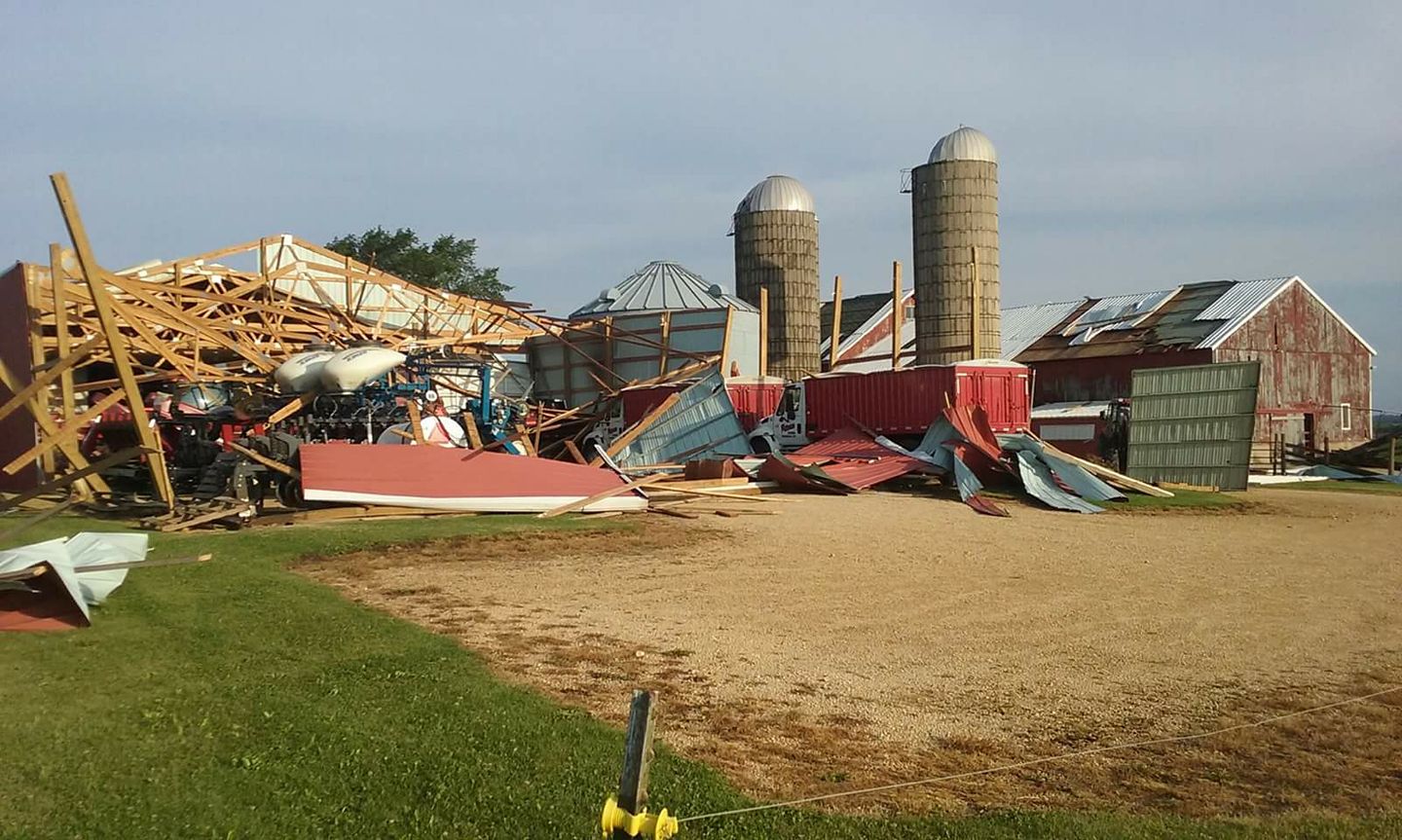 |
| South of Belvidere courtesy of the Kishwaukee Hill Flight Park |
 |
Media use of NWS Web News Stories is encouraged! Please acknowledge the NWS as the source of any news information accessed from this site. Additional recaps can be found on the NWS Chicago Past Events Page |
|