
Hazardous heat will continue across the Southern Plains, Gulf Coast and Desert Southwest through the weekend. Additional heat will build into the Great Basin and Northern Plains this weekend. A stalled front is expected to bring periods of heavy to excessive rainfall and flooding from the Tennessee Valley to the Southeast U.S on Friday. Read More >
|
An area of moderate to heavy snow moved northeastward across northern Illinois and far northwest Indiana during the late afternoon and early evening of Tuesday, December 29th. Snowfall rates of 1" to locally 2" per hour were observed this this band of snow. By mid-evening, warming temperatures aloft resulted in the precipitation mixing with sleet and rain before changing over to all rain for much of north-central and northeast Illinois by late in the evening. Air temperatures remained below freezing for several hours after the switch to rain, resulting in ice accumulations of 0.1"-0.2" for much of northeast Illinois late Tuesday evening into early Wednesday morning. This was the first significant winter precipitation event this season for most of the NWS Chicago forecast area with the exception of locations near the Wisconsin state line. The high snowfall rates during the late afternoon and evening resulted in major travel disruptions across northern Illinois and the Chicago metro. |
|
Fast Facts
Snow/Ice Totals
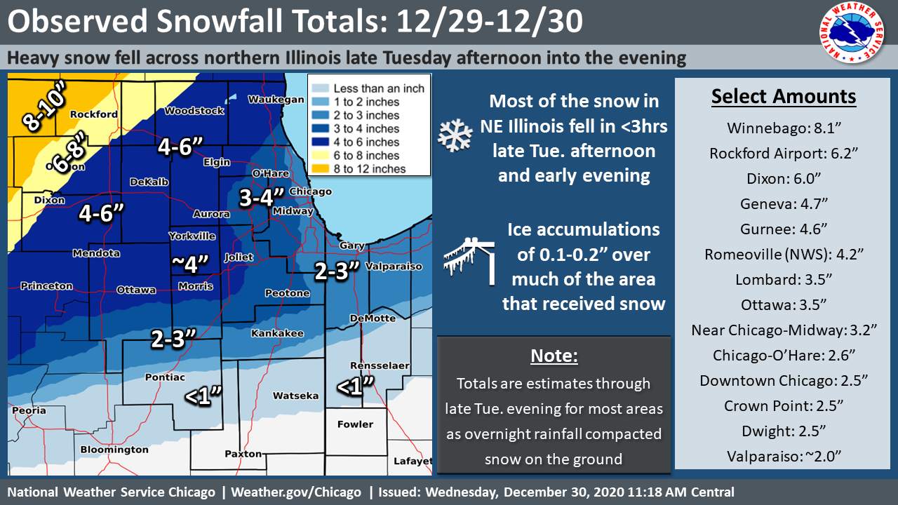 |
| Observed snowfall estimated from reports across the area during the event. |
PUBLIC INFORMATION STATEMENT
NATIONAL WEATHER SERVICE CHICAGO IL
1257 PM CST WED DEC 30 2020

...OBSERVED SNOWFALL FOR 12/29-12/30...

THE FOLLOWING ARE OBSERVED SNOWFALL TOTALS SINCE TUESDAY AFTERNOON.
EXCEPT FOR NORTH-CENTRAL ILLINOIS, TOTALS ARE GENERALLY ESTIMATES
THROUGH LATE TUESDAY BEFORE RAINFALL AND MELTING LATE TUESDAY EVENING
INTO EARLY WEDNESDAY MORNING REDUCED THE AMOUNT OF SNOW ON THE GROUND
BY AS MUCH OF 50 PERCENT ACROSS NORTHEAST ILLINOIS.

LOCATION                     AMOUNT    TIME/DATE       PROVIDER

...ILLINOIS...

...BOONE COUNTY...
CAPRON                       5.3 IN    0722 AM 12/30   COCORAHS

...COOK COUNTY...
PALATINE                     3.6 IN    0950 PM 12/29   PUBLIC
SCHAUMBURG                   3.2 IN    0930 PM 12/29   PUBLIC
3 SW MIDWAY AIRPORT          3.2 IN    0746 PM 12/29   CO-OP OBSERVER
ELK GROVE VILLAGE            3.0 IN    0738 PM 12/29   COCORAHS
CHICAGO RIDGE                3.0 IN    0630 PM 12/29   COCORAHS
OAK LAWN                     2.8 IN    0700 PM 12/29   PUBLIC
WEST RIDGE - CHICAGO         2.7 IN    0945 PM 12/29   COCORAHS
OHARE AIRPORT                2.6 IN    1205 AM 12/30   OFFICIAL NWS OBS
BRIDGEPORT - CHICAGO         2.5 IN    0900 PM 12/29   PUBLIC
MORTON GROVE                 2.5 IN    0700 PM 12/29   BROADCAST MEDIA

...DE KALB COUNTY...
DEKALB                       4.0 IN    0746 AM 12/30   CO-OP OBSERVER

...DUPAGE COUNTY...
BLOOMINGDALE                 3.7 IN    0634 AM 12/30   COCORAHS
LOMBARD                      3.5 IN    0920 PM 12/29   PUBLIC
CAROL STREAM                 3.4 IN    0700 PM 12/29   COCORAHS
WESTMONT                     2.9 IN    0715 AM 12/30   CO-OP OBSERVER
DOWNERS GROVE                2.8 IN    0850 PM 12/29   NWS EMPLOYEE

...GRUNDY COUNTY...
3 N CARBON HILL              4.0 IN    0757 AM 12/30   COCORAHS
MORRIS                       3.5 IN    0500 PM 12/29   EMERGENCY MNGR

...KANE COUNTY...
GENEVA                       4.7 IN    0628 AM 12/30   COCORAHS
ELBURN                       4.2 IN    0749 PM 12/29   PUBLIC
HAMPSHIRE                    4.0 IN    0900 PM 12/29   PUBLIC
BATAVIA                      3.6 IN    0900 PM 12/29   COCORAHS
NORTH AURORA                 3.5 IN    0855 PM 12/29   COCORAHS

...KANKAKEE COUNTY...
2 N BONFIELD                 2.4 IN    0420 PM 12/29   PUBLIC

...LA SALLE COUNTY...
PERU                         4.0 IN    0724 AM 12/30   COCORAHS
OTTAWA                       3.5 IN    0636 AM 12/30   COCORAHS

...LAKE COUNTY...
GRANDWOOD PARK 1 SE          4.6 IN    0700 AM 12/30   COCORAHS
BUFFALO GROVE                3.6 IN    1000 PM 12/29   COCORAHS
HIGHLAND PARK                3.0 IN    0639 AM 12/30   COCORAHS
LINDENHURST                  2.7 IN    0900 PM 12/29   COCORAHS
2 NW HAWTHORN WOODS          2.5 IN    0710 AM 12/30   CO-OP OBSERVER

...LEE COUNTY...
1 NNW DIXON                  6.0 IN    0926 PM 12/29   PUBLIC
NELSON 3 NNW                 5.0 IN    0800 AM 12/30   COCORAHS

...LIVINGSTON COUNTY...
DWIGHT                       2.5 IN    0743 AM 12/30   CO-OP OBSERVER

...MCHENRY COUNTY...
GREENWOOD                    5.5 IN    0700 AM 12/30   PUBLIC
4 NE UNION                   4.0 IN    0800 AM 12/30   COCORAHS
2 WNW BULL VALLEY            3.8 IN    0755 AM 12/30   COCORAHS
HUNTLEY                      3.0 IN    0845 PM 12/29   COCORAHS
CRYSTAL LAKE                 2.8 IN    0833 PM 12/29   CO-OP OBSERVER

...OGLE COUNTY...
6 SW FORRESTON               6.0 IN    0615 PM 12/29   PUBLIC

...WILL COUNTY...
NWS CHICAGO-ROMEOVILLE       4.2 IN    1207 AM 12/30   OFFICIAL NWS OBS
JOLIET                       3.7 IN    0630 PM 12/29   TRAINED SPOTTER
MANHATTAN                    3.5 IN    0915 PM 12/29   PUBLIC
4 SW FRANKFORT               3.2 IN    0900 PM 12/29   COCORAHS

...WINNEBAGO COUNTY...
LAKE SUMMERSET               9.5 IN    0700 AM 12/30   COCORAHS
WINNEBAGO                    8.1 IN    0700 AM 12/30   TRAINED SPOTTER
ROCKFORD AIRPORT             6.2 IN    0600 AM 12/30   OFFICIAL NWS OBS

...INDIANA...

...LAKE COUNTY...
HAMMOND                      2.3 IN    0800 PM 12/29   PUBLIC

...PORTER COUNTY...
BOONE GROVE                  2.2 IN    0900 PM 12/29   COCORAHS
VALPARAISO                   2.0 IN    0600 PM 12/29   PUBLIC

OBSERVATIONS ARE COLLECTED FROM A VARIETY OF SOURCES WITH VARYING
EQUIPMENT AND EXPOSURES. WE THANK ALL VOLUNTEER WEATHER OBSERVERS
FOR THEIR DEDICATION. NOT ALL DATA LISTED ARE CONSIDERED OFFICIAL.

$$
 |
Media use of NWS Web News Stories is encouraged! Additional recaps can be found on the NWS Chicago Science & Past Events Page. |
|

