
Dangerous heat will expand from the Gulf Coast into the Southern Plains and Desert Southwest through week's end. Additional extreme heat impacting the Pacific Northwest will shift to the northern Plains by the weekend. Tropical Storm Bertha is expected to continue to impact portions of the northern Gulf Coast from the western Florida Panhandle to southeastern Louisiana through tonight. Read More >
|
Fast Facts
|
Snow Totals
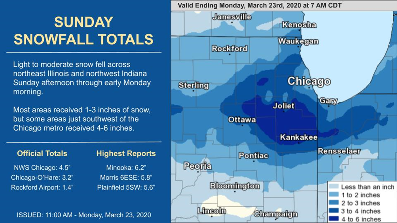 |
| Snowfall Map |
Public Information Statement
National Weather Service Chicago IL
1010 AM CDT Mon Mar 23 2020

...Morning Snowfall Roundup...

   The following are snow amounts for the previous 24 hours
   as measured in the morning by NWS Cooperative Observers
   and CoCoRaHS observers.
   Observations are usually taken at 7 AM.

   24-hour Snowfall Amounts for Monday (03/23/20)...


Northern Illinois                              Snow
  Location (County):                           fall(inches)

  Minooka (Grundy)..............................6.2
  Morris 6ESE (Grundy)..........................5.8
  Plainfield 5SW (Kendall)......................5.6
  Joliet 2n (Will)..............................5.5
  Coal City 4NNW (Grundy).......................5.3
  Carbon Hill 3.1N (Grundy).....................5.3
  Peotone (Will)................................5.3
  Somonauk 2NE (De Kalb)........................5.0
  Wilmington 3SE (Will).........................5.0
  Ottawa 2N (La Salle)..........................4.9
  Mokena 1W (Will)..............................4.9
  New Lenox 2SE (Will)..........................4.9
  New Lenox 3E (Will)...........................4.8
  Bourbonnais (Kankakee)........................4.7
  Buffalo Grove 2N (Lake).......................4.6
  Plainfield 2SSE (Will)........................4.6
  Geneva 4WSW (Kane)............................4.5
  Crete 3E (Will)...............................4.5
  Romeoville (Will).............................4.5
  Downers Grove 0.4NNE (Du Page)................4.4
  Park Forest 1NNE (Cook).......................4.2
  Homer Glen 1ENE (Will)........................4.2
  Lockport 1SE (Will)...........................4.2
  Oak Lawn (Cook)...............................4.0
  Chicago Ridge (Cook)..........................4.0
  Homewood (Cook)...............................4.0
  Roselle 1ESE (Du Page)........................4.0
  Sugar Grove 1NE (Kane)........................4.0
  St. Charles (Kane)............................4.0
  Manhattan 5ENE (Will).........................4.0
  Brandon Road Lock & Dam (Will)................4.0
  Kankakee (Kankakee)...........................4.0
  Manhattan (Will)..............................4.0
  Morris (Grundy)...............................4.0
  Paw Paw (Lee).................................4.0
  Hoffman Estates 2SE (Cook)....................3.9
  Hoffman Estates 5W (Cook).....................3.8
  Palos Park 1SW (Cook).........................3.8
  Aurora 4SE (Du Page)..........................3.8
  Batavia 2WNW (Kane)...........................3.8
  St. Charles 6NW (Kane)........................3.8
  Highwood 1S (Lake)............................3.8
  Lake Zurich (Lake)............................3.8
  Elgin (Kane)..................................3.6
  Elgin 1S (Kane)...............................3.6
  Midway Coop (Cook)............................3.6
  Earlville 3S (La Salle).......................3.5
  Palatine 1NNE (Cook)..........................3.5
  Cortland (De Kalb)............................3.5
  Montgomery 1SSE (Kendall).....................3.5
  Herscher 3E (Kankakee)........................3.5
  North Aurora 2NE (Kane).......................3.5
  Elgin 2W (Kane)...............................3.5
  Riverwoods (Lake).............................3.5
  Mendota (La Salle)............................3.5
  Park Forest (Cook)............................3.5
  Elk Grove Village 1ESE (Cook).................3.4
  Burr Ridge 2SW (Du Page)......................3.4
  Batavia 1WSW (Kane)...........................3.4
  Bridgeview 1NNW (Cook)........................3.2
  Schaumburg 2E (Cook)..........................3.2
  Elmhurst 2SE (Du Page)........................3.2
  Geneva 1SSW (Kane)............................3.2
  Ohare Airport (Cook)..........................3.2
  De Kalb (De Kalb).............................3.1
  Batavia (Kane)................................3.0
  DeKalb (De Kalb)..............................3.0
  Palatine 1E (Cook)............................3.0
  Elk Grove Village 2WSW (Cook).................3.0
  Countryside 1ENE (Cook).......................3.0
  De Kalb 1SW (De Kalb).........................3.0
  Wheaton 2NNE (Du Page)........................3.0
  Naperville 2SE (Du Page)......................3.0
  Gurnee 2W (Lake)..............................3.0
  Mundelein (Lake)..............................3.0
  Ottawa 1NW (La Salle).........................3.0
  Oak Park 2S (Cook)............................2.9
  La Grange Park 1SSW (Cook)....................2.9
  Naperville 4SSW (Will)........................2.9
  Elgin (Kane)..................................2.8
  Park Ridge (Cook).............................2.8
  Park Ridge 1WNW (Cook)........................2.8
  Mundelein (Lake)..............................2.8
  Batavia 1WNW (Kane)...........................2.7
  Harwood Heights (Cook)........................2.6
  Wonder Lake 1WNW (McHenry)....................2.6
  Westmont (Du Page)............................2.6
  Bolingbrook 3NE (Du Page).....................2.5
  Waukegan 2N (Lake)............................2.5
  Peru 1ENE (La Salle)..........................2.5
  Naperville 1NW (Du Page)......................2.4
  Genoa (De Kalb)...............................2.3
  Hebron (McHenry)..............................2.3
  Elmhurst (Du Page)............................2.3
  La Salle (La Salle)...........................2.3
  Cary (McHenry)................................2.3
  Mendota (La Salle)............................2.3
  Ashkum 5.6E (Iroquois)........................2.2
  Watseka 6.9WNW (Iroquois).....................2.2
  Streator 1WSW (La Salle)......................2.2
  Oak Park 1NNE (Cook)..........................2.1
  Steward (Lee).................................2.1
  Aurora (Kane).................................2.0
  Chatsworth (Livingston).......................2.0
  Harvard (McHenry).............................2.0
  Chicago 6ESE (Cook)...........................2.0
  Sterling 4NE (Lee)............................2.0
  Ashton (Lee)..................................2.0
  Lake Villa 1SSW (Lake)........................2.0
  Lake Villa 2WSW (Lake)........................2.0
  Woodstock 4SW (McHenry).......................2.0
  Algonquin 1N (McHenry)........................2.0
  Rockford 2ENE (Winnebago).....................2.0
  Streator (Livingston).........................2.0
  Crystal Lake 1WSW (McHenry)...................1.8
  Rockford 1NW (Winnebago)......................1.7
  McHenry (Stratton Lock & Dam) (McHenry).......1.7
  Bull Valley 2WNW (McHenry)....................1.5
  Woodstock 5nw (McHenry).......................1.5
  Rogers Park 2SW (Cook)........................1.4
  Rockford (Winnebago)..........................1.4
  Winnetka 1ESE (Cook)..........................1.3
  Lincolnwood 2E (Cook).........................1.3
  Oak Park 1SW (Cook)...........................1.0
  Marseilles Lock & Dam (La Salle)..............1.0
  Capron (Boone)................................0.8

Northwest Indiana                              Snow
  Location (County):                           fall(inches)

  Valparaiso 6SSW (Porter)......................4.5
  De Motte 4SW (Jasper).........................4.3
  De Motte 1NNW (Jasper)........................3.9
  Hebron 4NE (Porter)...........................3.9
  Dyer 1WNW (Lake)..............................3.8
  Munster 2NNW (Lake)...........................3.8
  Wheatfield 3S (Jasper)........................3.2
  De Motte 6S (Jasper)..........................3.0
  (w9mal)Merrillville 2NNW (Lake)...............3.0
  Valparaiso 4SW (Porter).......................3.0
  Crown Point 1N (Lake).........................2.8
  Porter 1S (Porter)............................2.7
  Gary 5ENE (Lake)..............................2.6
  Crown Point (Lake)............................2.5
  Morocco (Newton)..............................2.0
  Mount Ayr 2NNE (Newton).......................1.7
  Remington (Jasper)............................1.3
  Rensselaer (Jasper)...........................1.0
Snow Reports
PRELIMINARY LOCAL STORM REPORT...SUMMARY
NATIONAL WEATHER SERVICE CHICAGO IL
711 AM CDT MON MAR 23 2020

..TIME...   ...EVENT...      ...CITY LOCATION...     ...LAT.LON...
..DATE...   ....MAG....      ..COUNTY LOCATION..ST.. ...SOURCE....
            ..REMARKS..

0700 AM     SNOW             ROCKFORD AIRPORT        42.20N 89.10W
03/23/2020  M1.4 INCH        WINNEBAGO          IL   OFFICIAL NWS OBS

            LIQUID EQUIVALENT OF 0.12 IN.

0700 AM     SNOW             OHARE AIRPORT           41.98N 87.90W
03/23/2020  M3.2 INCH        COOK               IL   OFFICIAL NWS OBS

            LIQUID EQUIVALENT OF 0.21 IN.

0700 AM     SNOW             MOKENA                  41.53N 87.88W
03/23/2020  M4.9 INCH        WILL               IL   PUBLIC


0630 AM     SNOW             3 SW MIDWAY AIRPORT     41.74N 87.78W
03/23/2020  M3.6 INCH        COOK               IL   CO-OP OBSERVER

            LIQUID EQUIVALENT OF 0.31 IN.

0604 AM     SNOW             NWS CHICAGO-ROMEOVILLE  41.60N 88.08W
03/23/2020  M4.5 INCH        WILL               IL   OFFICIAL NWS OBS

            CORRECTS PREVIOUS SNOW REPORT FROM NWS
            CHICAGO-ROMEOVILLE. 0.32 LIQUID.

0603 AM     SNOW             BATAVIA                 41.85N 88.31W
03/23/2020  M3.0 INCH        KANE               IL   CO-OP OBSERVER

            0.25 LIQUID.

0432 AM     SNOW             HIGHWOOD                42.20N 87.81W
03/23/2020  M3.8 INCH        LAKE               IL   PUBLIC


0145 AM     SNOW             GRAYSLAKE               42.34N 88.04W
03/23/2020  M2.5 INCH        LAKE               IL   PUBLIC


0115 AM     SNOW             MARSEILLES              41.33N 88.71W
03/23/2020  M4.5 INCH        LA SALLE           IL   PUBLIC


1230 AM     SNOW             HOMEWOOD                41.56N 87.66W
03/23/2020  M3.8 INCH        COOK               IL   PUBLIC


1200 AM     SNOW             JOLIET                  41.53N 88.08W
03/23/2020  M5.1 INCH        WILL               IL   TRAINED SPOTTER
Late Season Snow Climatology
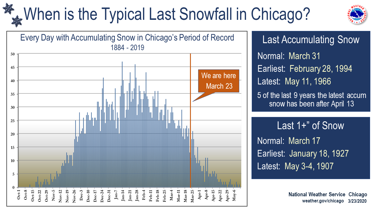 |
| Late season snowfall climatology. For more, see our Snow Climatology page. |
Additional
Photos
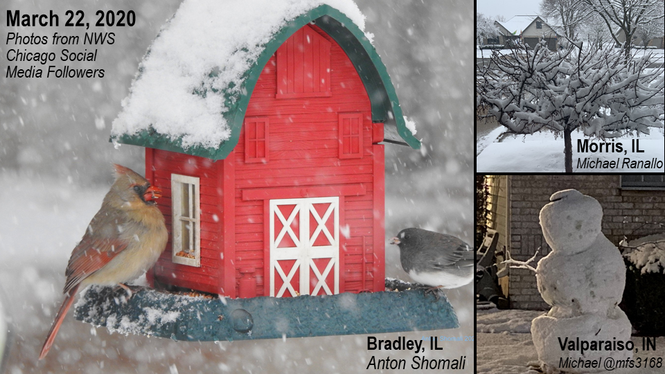 |
| Photos courtesy of NWS Chicago social media followers |
Links
 |
Media use of NWS Web News Stories is encouraged! Additional recaps can be found on the NWS Chicago Science & Past Events Page. |
|

