Numerous severe thunderstorms are expected across a broad region from the Ohio Valley to the Mid-Atlantic and Northeast States today into tonight. Swaths of damaging wind gusts are expected and some tornadoes are possible. Bertha is expected to bring tropical storm conditions to portions of the Gulf Coast from the Florida Panhandle westward to southeastern Louisiana later today and Wednesday. Read More >
|
Fast Facts
|
|
Rainfall
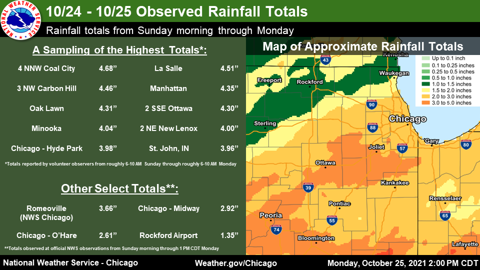 |
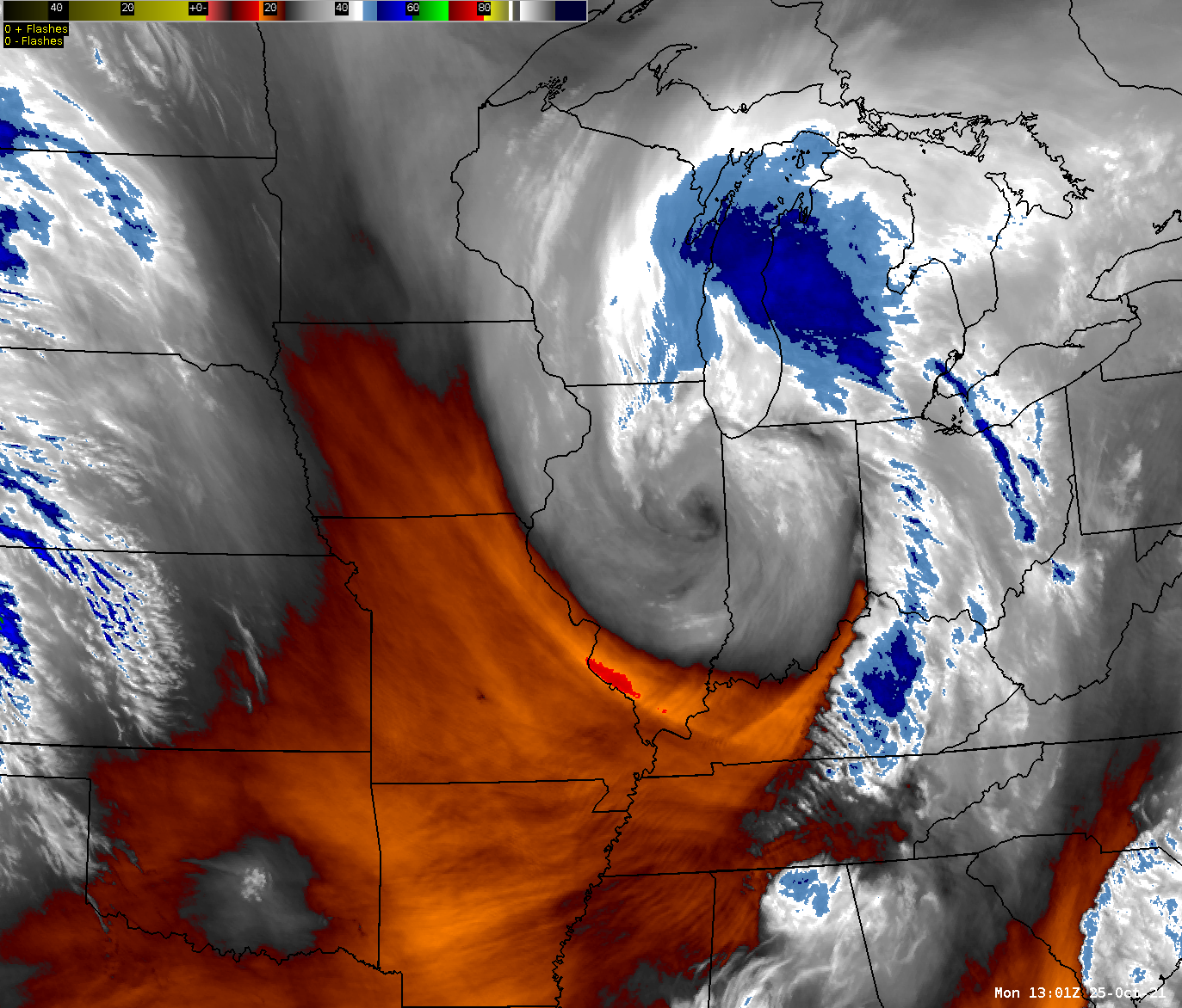
| Observed rainfall from October 24-25. |
The following is a list of rainfall reports through the early-mid morning of Monday October 25. Some light rain did fall after this time.
Public Information Statement National Weather Service Chicago IL 1113 AM CDT Mon Oct 25 2021 ...10/24-10/25 PRECIPITATION REPORTS... The following are rainfall amounts observed from the morning of Sunday, October 24 through the morning of Monday, October 25 as reported at official NWS observation sites and by volunteer COOP and CoCoRaHs observers. Location Amount Time/Date Provider ...Illinois... ...Boone County... Capron 1.39 in 0700 AM 10/25 COCORAHS Timberlane 1 SW 1.33 in 0700 AM 10/25 COCORAHS ...Cook County... Oak Lawn 4.31 in 0700 AM 10/25 COCORAHS Chicago - Hyde Park 3.98 in 0600 AM 10/25 COCORAHS Flossmoor 1 SE 3.63 in 0600 AM 10/25 COCORAHS Homewood 3.58 in 0700 AM 10/25 COCORAHS Oak Lawn 2 WNW 3.56 in 0800 AM 10/25 COCORAHS Chicago Heights 2 NNW 3.53 in 0800 AM 10/25 COCORAHS Park Forest 1 WNW 3.52 in 0730 AM 10/25 COCORAHS Midway Airport 3 SW 3.50 in 0700 AM 10/25 COOP Oak Lawn 1 WSW 3.43 in 0730 AM 10/25 COCORAHS Oak Forest 1 NNW 3.42 in 0700 AM 10/25 COCORAHS Lemont 1 SE 3.40 in 0800 AM 10/25 COCORAHS Chicago Ridge 3.35 in 0700 AM 10/25 COCORAHS Palos Park 4 W 3.34 in 0800 AM 10/25 COCORAHS Palos Park 2 WSW 3.26 in 0700 AM 10/25 COCORAHS Midlothian 1 SSE 3.21 in 0800 AM 10/25 COCORAHS Evanston 1 E 3.11 in 0800 AM 10/25 COCORAHS Oak Lawn 2 SE 3.10 in 0645 AM 10/25 COCORAHS Merrionette Park 1.7 NE 2.93 in 0800 AM 10/25 COCORAHS Park Forest 2.90 in 0510 AM 10/25 COOP Chicago - Midway Airport 2.89 in 1000 AM 10/25 ASOS Evergreen Park 2.85 in 0730 AM 10/25 COCORAHS Hoffman Estates 5 W 2.81 in 0725 AM 10/25 COCORAHS Northfield 2.80 in 0800 AM 10/25 COCORAHS Oak Park 1.0 NNE 2.79 in 0800 AM 10/25 COCORAHS Franklin Park 0.5 SSE 2.76 in 0800 AM 10/25 COCORAHS Forest Park 1 ENE 2.75 in 0740 AM 10/25 COCORAHS Chicago - North Center 2.73 in 0701 AM 10/25 COCORAHS La Grange Park 1 SSW 2.70 in 0700 AM 10/25 COCORAHS Winnetka 1 SE 2.68 in 0800 AM 10/25 COCORAHS Elk Grove Village 2 WSW 2.67 in 0655 AM 10/25 COCORAHS Mount Prospect 1 SSE 2.65 in 0700 AM 10/25 COCORAHS Chicago - OHare Airport 2.61 in 1000 AM 10/25 ASOS Mount Prospect 0.2 NNE 2.59 in 0700 AM 10/25 COCORAHS Evanston 1 SSW 2.58 in 0800 AM 10/25 COCORAHS Arlington Heights 1 W 2.55 in 0700 AM 10/25 COCORAHS Park Forest 1 NNE 2.54 in 0700 AM 10/25 COCORAHS Schaumburg 2 E 2.54 in 0700 AM 10/25 COCORAHS Evanston 2.53 in 0700 AM 10/25 COCORAHS Countryside 1 ENE 2.50 in 0500 AM 10/25 COCORAHS Chicago - West Ridge 2.50 in 0700 AM 10/25 COCORAHS Chicago - West Ridge 2.47 in 0700 AM 10/25 COCORAHS Wheeling - Chi. Exec. Arpt. 2.42 in 1000 AM 10/25 ASOS Schaumburg 2.9 WSW 2.37 in 0731 AM 10/25 COCORAHS Morton Grove 1 WNW 2.31 in 0700 AM 10/25 COCORAHS Forest Park 1 ESE 2.26 in 0600 AM 10/25 COCORAHS Elk Grove Village 1 ESE 2.24 in 0600 AM 10/25 COCORAHS Streamwood 1.1 WSW 2.22 in 0700 AM 10/25 COCORAHS Arlington Heights 2 NNW 2.18 in 0701 AM 10/25 COCORAHS Oak Park 1 NNE 2.08 in 0620 AM 10/25 COCORAHS Barrington 2.07 in 0800 AM 10/25 COOP Glencoe 2.06 in 0729 AM 10/25 COCORAHS Chicago - Albany Park 1.94 in 0700 AM 10/25 COCORAHS Palatine 1 NNE 1.89 in 0700 AM 10/25 COCORAHS Palatine 1.2 NW 1.80 in 0700 AM 10/25 COCORAHS ...De Kalb County... Malta 3 ESE 2.38 in 0700 AM 10/25 COCORAHS DeKalb 2.32 in 0645 AM 10/25 COCORAHS Genoa 2.17 in 0700 AM 10/25 COOP Cortland 2.06 in 0615 AM 10/25 COCORAHS Earlville 5 NNE 1.72 in 0700 AM 10/25 COCORAHS Cortland 1.66 in 0720 AM 10/25 COCORAHS Kingston 2 WNW 1.43 in 0700 AM 10/25 COCORAHS ...DuPage County... Willow Springs 2 SE 3.25 in 0800 AM 10/25 COOP Glen Ellyn 1 SW 3.21 in 0735 AM 10/25 COCORAHS Carol Stream 3.21 in 0830 AM 10/25 COCORAHS Naperville 3 SE 3.20 in 0700 AM 10/25 COCORAHS Morton Arboretum 3.16 in 0700 AM 10/25 COOP Bolingbrook 2.6 NE 3.15 in 0800 AM 10/25 COCORAHS Bolingbrook 3 NE 3.12 in 0700 AM 10/25 COCORAHS Westmont 1 SSW 3.10 in 0800 AM 10/25 COCORAHS Elmhurst 2 SE 3.08 in 0700 AM 10/25 COCORAHS Bloomingdale 1 SSE 3.08 in 0745 AM 10/25 COCORAHS Lombard 1.2 N 2.95 in 0800 AM 10/25 COCORAHS Aurora 4 ESE 2.92 in 0700 AM 10/25 COCORAHS Clarendon Hills 1 NW 2.84 in 0700 AM 10/25 COCORAHS Darien 2 SE 2.78 in 0715 AM 10/25 COCORAHS Lisle 1 WSW 2.77 in 0700 AM 10/25 COCORAHS Aurora 4 ESE 2.77 in 0700 AM 10/25 COCORAHS Naperville 0.9 ENE 2.73 in 0700 AM 10/25 COCORAHS Lombard 1 NW 2.72 in 0800 AM 10/25 COCORAHS Lombard 1.0 WSW 2.67 in 0700 AM 10/25 COCORAHS Lombard 2.65 in 0700 AM 10/25 COCORAHS Villa Park 1 NW 2.59 in 0600 AM 10/25 COCORAHS Elmhurst 1 SW 2.58 in 0700 AM 10/25 COCORAHS Clarendon Hills 2.57 in 0700 AM 10/25 UCOOP Glen Ellyn 1 W 2.55 in 0700 AM 10/25 COCORAHS West Chicago 4 SE 2.52 in 0708 AM 10/25 COCORAHS West Chicago 3.0 SSE 2.49 in 0700 AM 10/25 COCORAHS Villa Park 2.48 in 0700 AM 10/25 COCORAHS Wheaton 1 NNW 2.42 in 0700 AM 10/25 COCORAHS West Chicago 4 NNE 2.41 in 0700 AM 10/25 COCORAHS Elmhurst 1 SE 2.40 in 0700 AM 10/25 COCORAHS Winfield 2.39 in 0700 AM 10/25 COCORAHS Bartlett 2 S 2.39 in 0700 AM 10/25 COCORAHS West Chicago - DuPage Arpt. 2.37 in 1000 AM 10/25 ASOS Winfield 0.8 ENE 2.32 in 0730 AM 10/25 COCORAHS Naperville 2.22 in 0500 AM 10/25 COCORAHS ...Ford County... Melvin 4 WSW 3.16 in 0700 AM 10/25 COCORAHS Gibson City 3 WNW 3.12 in 0700 AM 10/25 COCORAHS ...Grundy County... Coal City 4 NNW 4.68 in 0700 AM 10/25 UCOOP Carbon Hill 3 NW 4.46 in 0800 AM 10/25 COCORAHS Carbon Hill 3 NNW 4.45 in 0700 AM 10/25 COCORAHS Morris 1 NW 4.18 in 0800 AM 10/25 COOP Carbon Hill 3 NE 4.09 in 0630 AM 10/25 COCORAHS Morris 2 W 4.06 in 0700 AM 10/25 COCORAHS Minooka 4.04 in 0800 AM 10/25 COCORAHS Morris 5 NNW 3.91 in 0530 AM 10/25 COCORAHS Morris 5 NW 3.61 in 0850 AM 10/25 COCORAHS 2 SE Mazon 3.25 in 0700 AM 10/25 COCORAHS Morris 2 SSE 3.15 in 0700 AM 10/25 COCORAHS Coal City 2.69 in 0900 AM 10/25 COCORAHS ...Iroquois County... Cissna Park 1 S 3.88 in 0500 AM 10/25 COCORAHS Milford 3.5 ENE 3.69 in 0700 AM 10/25 COCORAHS Chebanse 2 WSW 2.85 in 0600 AM 10/25 COCORAHS Crescent City 2 N 2.83 in 0600 AM 10/25 COCORAHS Ashkum 6 E 2.67 in 0700 AM 10/25 COCORAHS Buckley 2.48 in 0800 AM 10/25 COCORAHS Chebanse 2.46 in 0700 AM 10/25 COCORAHS 4 ESE Clifton 2.21 in 0600 AM 10/25 COCORAHS ...Kane County... Aurora 2 W 3.35 in 0700 AM 10/25 COCORAHS Aurora 3.29 in 0700 AM 10/25 COOP Sugar Grove 1 NNW 2.88 in 0700 AM 10/25 COCORAHS St. Charles 1 ENE 2.67 in 0800 AM 10/25 COCORAHS Geneva 1 SSW 2.64 in 0730 AM 10/25 COCORAHS Geneva 1 SSW 2.51 in 0700 AM 10/25 COCORAHS Aurora 3 WSW 2.50 in 0624 AM 10/25 COCORAHS Geneva 2 WNW 2.50 in 0700 AM 10/25 COCORAHS Batavia 1 NW 2.40 in 0700 AM 10/25 COCORAHS Elgin 2.34 in 0800 AM 10/25 UCOOP Elgin 1 SSW 2.34 in 0800 AM 10/25 COCORAHS Elburn 2.33 in 0700 AM 10/25 COCORAHS Batavia 3.4 WSW 2.32 in 0630 AM 10/25 COCORAHS Batavia 0.3 SE 2.32 in 0800 AM 10/25 COCORAHS North Aurora 1 ENE 2.29 in 0550 AM 10/25 COCORAHS Geneva 2.27 in 0700 AM 10/25 COCORAHS Campton Hills 3 NNE 2.24 in 0700 AM 10/25 COCORAHS Elgin 8 WSW 2.20 in 0847 AM 10/25 COCORAHS Elgin 3 W 2.17 in 0645 AM 10/25 COCORAHS Kaneville 3 NNW 2.14 in 0700 AM 10/25 COCORAHS Batavia 2.10 in 0600 AM 10/25 UCOOP Batavia 0.8 W 2.10 in 0725 AM 10/25 COCORAHS Geneva 2.10 in 0800 AM 10/25 COCORAHS Elgin 2.00 in 0700 AM 10/25 COOP 4 WNW Kaneville 1.98 in 0600 AM 10/25 COCORAHS Geneva 4 WSW 1.96 in 0500 AM 10/25 COCORAHS Gilberts 1 NE 1.87 in 0705 AM 10/25 COCORAHS Sugar Grove 1 NNE 1.62 in 0700 AM 10/25 COCORAHS Sleepy Hollow 1 W 1.43 in 0700 AM 10/25 COCORAHS Elgin 3 WNW 1.31 in 0700 AM 10/25 COCORAHS ...Kankakee County... 2 NE Limestone 3.60 in 0700 AM 10/25 COCORAHS Bourbonnais 3.50 in 0700 AM 10/25 COOP Kankakee 3.05 in 0700 AM 10/25 COOP Manteno 1 W 2.91 in 0800 AM 10/25 COCORAHS Herscher 3 E 2.82 in 0702 AM 10/25 COCORAHS 2 ESE Herscher 2.73 in 0700 AM 10/25 COCORAHS Kankakee 1.4 WSW 2.65 in 0600 AM 10/25 COCORAHS Aroma Park 0.6 S 2.62 in 0700 AM 10/25 COCORAHS Chebanse 2.60 in 0600 AM 10/25 COCORAHS Chebanse 1 ENE 2.46 in 0400 AM 10/25 COCORAHS St. Anne 2.32 in 0700 AM 10/25 COOP ...Kendall County... Plainfield 4 SW 3.60 in 0700 AM 10/25 COCORAHS Yorkville 1.0 N 3.52 in 0700 AM 10/25 COCORAHS Newark 2.2 NE 3.41 in 0700 AM 10/25 COCORAHS Oswego 3 NW 3.22 in 0748 AM 10/25 COCORAHS Oswego 4 SE 3.16 in 0700 AM 10/25 COCORAHS Boulder Hill 4 E 3.14 in 0747 AM 10/25 COCORAHS Boulder Hill 1 NNE 3.12 in 0730 AM 10/25 COCORAHS Yorkville 0.9 SSW 2.91 in 0700 AM 10/25 COCORAHS Yorkville 2.1 NNW 2.90 in 0800 AM 10/25 COCORAHS Plano 2.32 in 0700 AM 10/25 COCORAHS ...La Salle County... La Salle 4.51 in 0700 AM 10/25 COCORAHS 2 SSE Ottawa 4.30 in 0700 AM 10/25 COCORAHS Seneca 3.98 in 0700 AM 10/25 COCORAHS Streator 1 WSW 3.84 in 0700 AM 10/25 COCORAHS Ottawa 1 N 3.57 in 0700 AM 10/25 COCORAHS Peru 1 NNE 3.50 in 0700 AM 10/25 COCORAHS Ottawa 3.38 in 0658 AM 10/25 COCORAHS Ottawa - Buffalo Rock SP 3.35 in 0725 AM 10/25 COOP Mendota 2.92 in 0730 AM 10/25 COCORAHS Troy Grove 4 ESE 2.77 in 0800 AM 10/25 COCORAHS Earlville 3 S 2.67 in 0600 AM 10/25 COOP Mendota 1 SE 2.58 in 0700 AM 10/25 COOP Peru 2.37 in 0700 AM 10/25 COCORAHS Marseilles 3 W 2.10 in 0600 AM 10/25 COOP ...Lake County... Bannockburn 2.62 in 0800 AM 10/25 COCORAHS Lake Forest 1 NNW 2.58 in 0800 AM 10/25 COCORAHS Highwood 2.52 in 0700 AM 10/25 COCORAHS Buffalo Grove 1 ESE 2.36 in 0700 AM 10/25 COCORAHS Riverwoods 1 NE 2.22 in 0700 AM 10/25 COCORAHS Lake Bluff 2 W 2.20 in 0700 AM 10/25 COCORAHS Buffalo Grove 2 N 1.96 in 0700 AM 10/25 COCORAHS Waukegan 2 N 1.91 in 0800 AM 10/25 COCORAHS Libertyville 1.88 in 0735 AM 10/25 COCORAHS Waukegan Airport 1.84 in 1000 AM 10/25 ASOS Mundelein 1 NNE 1.81 in 0815 AM 10/25 COCORAHS Mundelein 4 WSW 1.77 in 0700 AM 10/25 COOP Lake Zurich 1 N 1.70 in 0600 AM 10/25 COCORAHS North Barrington 1.3 S 1.66 in 0700 AM 10/25 COCORAHS Wadsworth 1.4 S 1.65 in 0747 AM 10/25 COCORAHS Winthrop Harbor 1 SW 1.65 in 0845 AM 10/25 COCORAHS Mundelein 1.6 WNW 1.58 in 0800 AM 10/25 COCORAHS Grandwood Park 1 SE 1.53 in 0800 AM 10/25 COCORAHS Grayslake 1 WNW 1.48 in 0600 AM 10/25 COCORAHS Long Lake 1.48 in 0701 AM 10/25 COCORAHS Fox Lake Hills 1.46 in 0700 AM 10/25 COCORAHS Lindenhurst 1 NE 1.32 in 0800 AM 10/25 COCORAHS Lake Villa 1 SW 1.29 in 0730 AM 10/25 COCORAHS Winthrop Harbor 1.18 in 0830 AM 10/25 COCORAHS Lake Zurich 1.4 W 1.16 in 0600 AM 10/25 COCORAHS ...Lee County... Paw Paw 2 S 2.16 in 0700 AM 10/25 COOP Steward 3 S 1.84 in 0700 AM 10/25 COOP Dixon 1 NE 1.75 in 0700 AM 10/25 COCORAHS Dixon 3 NNW 1.70 in 0830 AM 10/25 COCORAHS Amboy 1 WSW 1.48 in 0629 AM 10/25 COCORAHS Nelson 3 NNW 1.30 in 0800 AM 10/25 COCORAHS ...Livingston County... Dwight 3.60 in 0700 AM 10/25 COOP Cropsey 1 NE 2.79 in 0800 AM 10/25 COCORAHS Fairbury 4.7 SSE 2.63 in 0800 AM 10/25 COCORAHS Chatsworth 2.33 in 0700 AM 10/25 COOP Chatsworth 1 S 2.28 in 0700 AM 10/25 COCORAHS Emington 2 SSE 2.23 in 0650 AM 10/25 COCORAHS ...McHenry County... Trout Valley 1.61 in 0700 AM 10/25 COCORAHS McHenry 1 ENE 1.50 in 0905 AM 10/25 COCORAHS Huntley 1.49 in 0845 AM 10/25 COCORAHS Lakemoor 2 NW 1.45 in 0630 AM 10/25 COCORAHS Marengo 1.41 in 0700 AM 10/25 COCORAHS Crystal Lake 1 WSW 1.39 in 0700 AM 10/25 COCORAHS 1 ESE Lakewood 1.38 in 0700 AM 10/25 COCORAHS Woodstock 4 SW 1.36 in 0700 AM 10/25 COCORAHS McHenry Lock and Dam 1.35 in 0800 AM 10/25 COOP Harvard 4.4 NNE 1.25 in 0700 AM 10/25 COCORAHS Hebron 2 WSW 1.24 in 0700 AM 10/25 UCOOP Bull Valley 2 WNW 1.19 in 0800 AM 10/25 COCORAHS Marengo 1.18 in 0700 AM 10/25 COCORAHS Woodstock 5 NW 1.11 in 0700 AM 10/25 COOP ...Will County... Manhattan 4.35 in 0800 AM 10/25 COCORAHS Channahon 3 SE 4.16 in 0700 AM 10/25 COCORAHS Channahon 1 NE 4.04 in 0700 AM 10/25 COCORAHS Manhattan 2 SE 4.02 in 0730 AM 10/25 COCORAHS New Lenox 2 NE 4.00 in 0800 AM 10/25 COCORAHS Crete 3 E 3.93 in 0700 AM 10/25 COCORAHS Peotone 0.5 SE 3.90 in 0730 AM 10/25 COCORAHS Frankfort 1 ESE 3.82 in 0700 AM 10/25 COCORAHS New Lenox 1 SSE 3.81 in 0700 AM 10/25 COCORAHS Manhattan 1 E 3.77 in 0800 AM 10/25 COCORAHS Manhattan 5 ENE 3.71 in 0800 AM 10/25 COCORAHS Mokena 2 WSW 3.67 in 0700 AM 10/25 COCORAHS Peotone 3.66 in 0600 AM 10/25 COOP Peotone 3.66 in 0600 AM 10/25 COCORAHS Monee 5 SE 3.65 in 0800 AM 10/25 COCORAHS Romeoville - NWS Chicago 3.64 in 1000 AM 10/25 Official NWS Obs Joliet 2 N 3.63 in 0700 AM 10/25 UCOOP Joliet 2.7 NW 3.61 in 0600 AM 10/25 COCORAHS Plainfield 1.7 WNW 3.58 in 0700 AM 10/25 COCORAHS New Lenox 2 W 3.56 in 0800 AM 10/25 COCORAHS Crystal Lawns 2 S 3.55 in 0700 AM 10/25 COCORAHS New Lenox 1 SE 3.55 in 0800 AM 10/25 COCORAHS Manhattan 5 ENE 3.54 in 0800 AM 10/25 COOP Crete 3 SSW 3.54 in 0700 AM 10/25 COCORAHS Lockport 2 SE 3.50 in 0700 AM 10/25 COCORAHS Homer Glen 3 S 3.48 in 0700 AM 10/25 COCORAHS Joliet 3 WNW 3.48 in 0700 AM 10/25 COCORAHS Plainfield 3 ESE 3.47 in 0900 AM 10/25 COCORAHS Beecher 4 ENE 3.40 in 0800 AM 10/25 COCORAHS Monee 5 W 3.34 in 0750 AM 10/25 COCORAHS Lakewood Shores 1 SE 3.30 in 0630 AM 10/25 COCORAHS New Lenox 2 SW 3.26 in 0700 AM 10/25 COCORAHS Homer Glen 1 NNE 3.18 in 0700 AM 10/25 COCORAHS 1 NW Rockdale 3.13 in 0800 AM 10/25 COCORAHS Naperville 4 SE 3.11 in 0855 AM 10/25 COCORAHS Beecher 3 SE 3.04 in 0700 AM 10/25 COCORAHS Wilmington 3.04 in 0700 AM 10/25 COCORAHS Lockport 5.0 W 2.99 in 0800 AM 10/25 COCORAHS Plainfield 2 SSE 2.91 in 0700 AM 10/25 COCORAHS Naperville 5 SSW 2.81 in 0730 AM 10/25 COCORAHS Joliet 0.8 E 2.77 in 0600 AM 10/25 COCORAHS Homer Glen 2 NNE 2.08 in 0700 AM 10/25 COCORAHS ...Winnebago County... Rockford 3 WSW 1.79 in 0700 AM 10/25 COCORAHS Rockford 2 ENE 1.59 in 0900 AM 10/25 COCORAHS Winnebago 5 SE 1.56 in 0630 AM 10/25 COCORAHS 4 NNW Rockford 1.47 in 0700 AM 10/25 COCORAHS Loves Park 2.5 SSE 1.41 in 0700 AM 10/25 COCORAHS Rockton 3.1 SW 1.38 in 0630 AM 10/25 COCORAHS Rockford Airport 1.35 in 1000 AM 10/25 ASOS Rockford 4 S 1.35 in 0700 AM 10/25 COCORAHS Machesney Park 1 NW 1.27 in 0500 AM 10/25 COCORAHS ...Indiana... ...Jasper County... Rensselaer 2 N 3.35 in 0800 AM 10/25 COCORAHS Baileys Corner 5 S 3.20 in 0500 AM 10/25 COCORAHS Rensselaer 4 N 3.20 in 0700 AM 10/25 COCORAHS Stoutsburg 1 WNW 3.14 in 0800 AM 10/25 COCORAHS Rensselaer 2 SW 3.00 in 0730 AM 10/25 COOP Collegeville 2.91 in 0600 AM 10/25 COCORAHS DeMotte 2.83 in 0600 AM 10/25 COCORAHS Stoutsburg 1 SW 2.82 in 0700 AM 10/25 COCORAHS Rensselaer 5 NW 2.78 in 0600 AM 10/25 COCORAHS DeMotte 2.77 in 0800 AM 10/25 COCORAHS DeMotte 2 WSW 2.75 in 0700 AM 10/25 COCORAHS Baileys Corner 5 W 2.65 in 0700 AM 10/25 COCORAHS Remington 2.58 in 0700 AM 10/25 COCORAHS De Motte 6 S 2.55 in 0700 AM 10/25 COCORAHS Roselawn 3 ENE 2.52 in 0700 AM 10/25 COCORAHS Wheatfield 3 SSE 2.47 in 0700 AM 10/25 COCORAHS ...Lake County... St. John 3.96 in 0600 AM 10/25 COCORAHS Highland 1 SW 3.81 in 0700 AM 10/25 COCORAHS St. John 3 SSE 3.61 in 0700 AM 10/25 COCORAHS Griffith 3.52 in 0600 AM 10/25 COCORAHS Dyer 3.50 in 0630 AM 10/25 COCORAHS Schererville 1 E 3.50 in 0800 AM 10/25 COCORAHS Hebron 3 SSW 3.42 in 0800 AM 10/25 COCORAHS Hebron 6 SSW 3.39 in 0800 AM 10/25 COCORAHS Hammond 2 N 3.35 in 0645 AM 10/25 COCORAHS Gary 5 ENE 3.07 in 0700 AM 10/25 COCORAHS Hobart 1.1 S 3.02 in 0700 AM 10/25 COCORAHS Hobart 1 ENE 2.89 in 0615 AM 10/25 COCORAHS Crown Point 2.78 in 0730 AM 10/25 COOP Crown Point 2 NNE 2.78 in 0800 AM 10/25 COCORAHS Cedar Lake 2 NNW 2.65 in 0600 AM 10/25 COCORAHS Schererville 1 E 2.61 in 0800 AM 10/25 COCORAHS ...Newton County... Kentland 2 SSE 3.08 in 0700 AM 10/25 COCORAHS Morocco 2.89 in 0600 AM 10/25 COOP Brook 4 W 2.88 in 0700 AM 10/25 COCORAHS Mount Ayr 2 NNE 2.60 in 0820 AM 10/25 COCORAHS ...Porter County... Valparaiso 4 SW 3.24 in 0600 AM 10/25 COCORAHS Valparaiso 2 NNE 3.14 in 0808 AM 10/25 COCORAHS Wanatah 3.03 in 0700 AM 10/25 COOP Valparaiso 1 N 2.97 in 0549 AM 10/25 COCORAHS Lakes of the Four Seasons 2.93 in 0830 AM 10/25 COCORAHS Beverly Shores 0.8 W 2.90 in 0800 AM 10/25 COCORAHS Valparaiso 2.6 WNW 2.89 in 0600 AM 10/25 COCORAHS Porter 2.86 in 0700 AM 10/25 COCORAHS Valparaiso 2 NE 2.85 in 0700 AM 10/25 COCORAHS Valparaiso 2 NNW 2.84 in 0750 AM 10/25 COCORAHS Valparaiso 0.6 SE 2.80 in 0725 AM 10/25 COCORAHS Valparaiso Airport 2.76 in 1000 AM 10/25 ASOS Chesterton 2 E 2.75 in 0630 AM 10/25 COCORAHS Valparaiso 2 NW 2.71 in 0615 AM 10/25 COCORAHS Portage 3 E 2.70 in 0700 AM 10/25 COCORAHS Boone Grove 4 NNE 2.42 in 0515 AM 10/25 COCORAHS Porter 1 WNW 2.40 in 0700 AM 10/25 COCORAHS Chesterton 4 ESE 1.86 in 0700 AM 10/25 COCORAHS Observations are collected from a variety of sources with varying equipment and exposures. We thank all volunteer weather observers for their dedication. Not all data listed are considered official.​
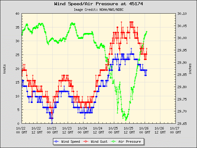
Winds
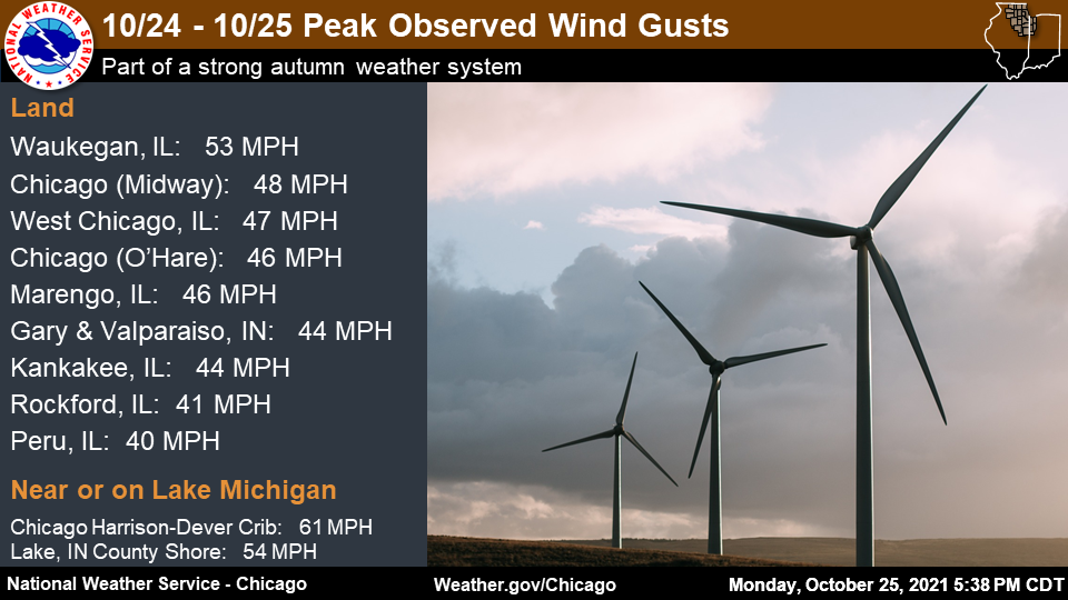 |
| Peak wind gusts. |
Public Information Statement
National Weather Service Chicago IL
530 PM CDT Mon Oct 25 2021 /630 PM EDT Mon Oct 25 2021/

...HIGHEST OBSERVED WIND GUSTS FROM OCTOBER 24-25 2021...

Observations are collected from a variety of sources with varying
equipment and exposures. We thank all volunteer weather observers
for their dedication. Not all data listed are considered official.

Land Location                Speed     Time/Date       Provider
---------------------------------------------------------------
Waukegan Airport             53 MPH    1244 AM 10/25   ASOS
Chicago Midway               48 MPH    0931 AM 10/25   ASOS
West Chicago - DuPage Arpt.  47 MPH    0821 PM 10/24   ASOS
Marengo 5 NW (McHenry DOT)   46 MPH    1150 PM 10/24   MESOWEST
Sugar Grove - Aurora Arpt.   46 MPH    1138 PM 10/24   ASOS
Chicago O`Hare               46 MPH    0744 AM 10/25   ASOS
Gary Airport                 44 MPH    0245 PM 10/25   AWOS
Kankakee Airport             44 MPH    0636 PM 10/24   AWOS
Pontiac Airport              44 MPH    0555 PM 10/24   AWOS
Valparaiso Airport           44 MPH    0734 PM 10/24   ASOS
Wheeling - Chicago Exec. Arp 43 MPH    1018 AM 10/25   ASOS
Sterling/Rock Falls Airport  43 MPH    0616 PM 10/24   AWOS
Rensselaer Airport           43 MPH    0735 PM 10/24   AWOS
Romeoville - Lewis Airport   41 MPH    1015 AM 10/25   AWOS
Rockford Airport             41 MPH    1037 PM 10/24   ASOS
Lansing Airport              40 MPH    1055 AM 10/25   AWOS
Peru Airport                 40 MPH    0655 PM 10/24   AWOS
Morris Airport               38 MPH    0735 PM 10/24   AWOS
DeKalb Airport               38 MPH    0935 AM 10/25   AWOS
Joliet Airport               35 MPH    0835 PM 10/24   AWOS


Marine Location              Speed     Time/Date       Provider
---------------------------------------------------------------
Harrison-Dever Crib          61 MPH    0920 AM 10/25   NDBC
Cline Ave Bridge - Lake IN   54 MPH    0931 AM 10/25   WXFLOW
Waukegan Harbor              49 MPH    0100 AM 10/25   NDBC
2 WNW Michigan City          48 MPH    1130 AM 10/25   NDBC
Calumet Harbor               44 MPH    1006 AM 10/25   NOS-NWLON
Wilmette Buoy                43 MPH    0940 AM 10/25   NDBC
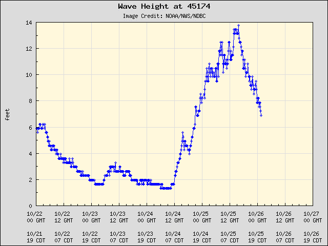
Waves
Waves were measured as high as 13.9 ft at the Wilmette buoy. The waves caused flooding along the city of Chicago's bike and walking path.
 |
 |
| Observed waves at Wilmette, IL buoy | Observed winds and pressure at Wilmette, IL buoy |
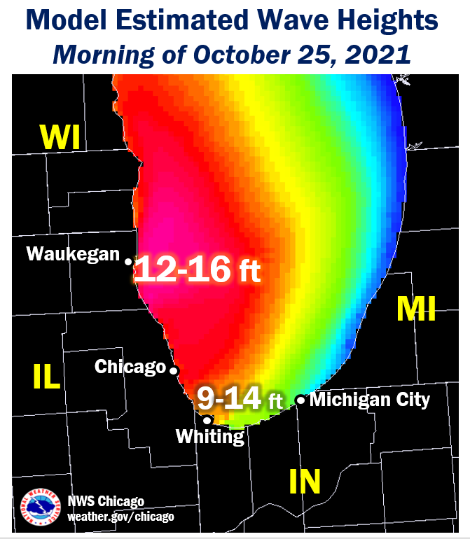 |
| Estimated wave heights from model guidance, adapted for observations. |
 |
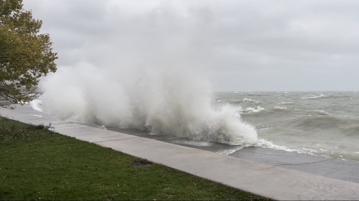 |
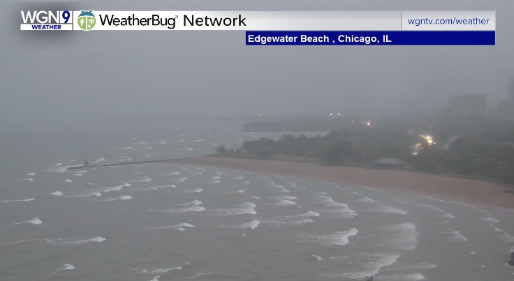
| Webacm imagery of Edgewater Beach in Chicago during late Sunday afternoon, October 24, courtesy of WGN Chicago. | Photo of high waves at 31st St. Beach on late Sunday afternoon, October 24. Courtesy of Twitter user @bpsoxgal. |
Storm Reports
PRELIMINARY LOCAL STORM REPORT...SUMMARY
NATIONAL WEATHER SERVICE CHICAGO IL
938 PM CDT MON OCT 25 2021

..TIME...   ...EVENT...      ...CITY LOCATION...     ...LAT.LON...
..DATE...   ....MAG....      ..COUNTY LOCATION..ST.. ...SOURCE....
            ..REMARKS..

0736 PM     NON-TSTM WND GST 2 ENE REMINGTON         40.77N 87.12W
10/24/2021  M53 MPH          JASPER             IN   MESONET

            MESONET STATION IN048 1.7 E REMINGTON
            (INDOT).

0916 PM     NON-TSTM WND GST 1 NNW EAST CHICAGO      41.65N 87.47W
10/24/2021  M52 MPH          LAKE               IN   MESONET

            MESONET STATION XCAV CLINE AVENUE BRIDGE.

1055 PM     FLOOD            1 SE GIBSON CITY        40.46N 88.37W
10/24/2021                   FORD               IL   BROADCAST MEDIA

            PHOTOS SHARED VIA SOCIAL MEDIA SHOW MINOR
            FLOODING OF STREETS AND PROPERTY IN GIBSON
            CITY. DELAYED REPORT.

1120 PM     NON-TSTM WND GST 4 NW HARVARD            42.47N 88.66W
10/24/2021  M55 MPH          MCHENRY            IL   MESONET

            MESONET STATION IMC05 HARVARD 4 NW (MCHENRY
            DOT).

1255 AM     NON-TSTM WND GST 1 SW BEACH PARK         42.42N 87.87W
10/25/2021  M53 MPH          LAKE               IL   ASOS

            ASOS STATION KUGN WAUKEGAN AIRPORT.

0345 AM     FLOOD            2 N HIGHLAND            41.57N 87.46W
10/25/2021                   LAKE               IN   PUBLIC

            REPORT SHARED VIA SOCIAL MEDIA OF INNER
            LANES CLOSED ON I-80 I-94 DUE TO FLOODING.
            DELAYED REPORT.

0520 AM     FLOOD            GLENVIEW                42.08N 87.81W
10/25/2021                   COOK               IL   BROADCAST MEDIA

            BROADCAST MEDIA REPORTS LAKE AVENUE CLOSED
            IN GLENVIEW NEAR UNDERPASS AT LEHIGH AVENUE.
            DELAYED REPORT.

0630 AM     NON-TSTM WND DMG CRYSTAL LAKE            42.25N 88.32W
10/25/2021                   MCHENRY            IL   PUBLIC

            PHOTO SHARED ON SOCIAL MEDIA OF A LARGE TREE
            LIMB DOWNED. TIME OF OCCURRENCE IS ESTIMATED
            BASED ON TIMING OF PEAK WINDS OBSERVED ON
            NEARBY PERSONAL WEATHER STATIONS.

0730 AM     NON-TSTM WND DMG ROGERS PARK - CHICAGO   42.01N 87.66W
10/25/2021                   COOK               IL   PUBLIC

            LARGE TREE AND LIGHT POLE DOWNED ONTO
            SHERIDAN ROAD. TIME ESTIMATED.

0800 AM     LAKESHORE FLOOD  1 NW NAVY PIER          41.90N 87.62W
10/25/2021                   COOK               IL   EMERGENCY MNGR

            FLOODING OF THE CHICAGO BIKE AND WALKING
            PATH IN PLACES, RELAYED BY CHICAGO OEMC.

0920 AM     NON-TSTM WND GST HARRISON-DEVER CRIB     41.92N 87.57W
10/25/2021  M61 MPH          LMZ741             IL   C-MAN STATION

            MEASURED AT THE CHICAGO HARRISON-DEVER CRIB.

0931 AM     NON-TSTM WND GST 1 NNW EAST CHICAGO      41.65N 87.47W
10/25/2021  M54 MPH          LAKE               IN   MESONET

            MEASURED AT THE CLINE AVENUE BRIDGE.

0935 AM     FLOOD            CISSNA PARK             40.56N 87.89W
10/25/2021                   IROQUOIS           IL   BROADCAST MEDIA

            MULTIPLE PHOTOS AND VIDEOS SHARED BY WCIA
            INDICATE CONTINUED FLOODING NEAR AND IN
            CISSNA PARK, INCLUDING 500 NORTH ROAD AT
            IL-49. CREEKS OUT OF THEIR BANKS NEARING
            ROADWAYS AND STRUCTURES.

1000 AM     FLOOD            3 E CRETE               41.44N 87.57W
10/25/2021                   WILL               IL   DEPT OF HIGHWAYS

            VIDEO SHARED BY VILLAGE OF CRETE VIA SOCIAL
            MEDIA SHOWS FLOODING OF ROADWAY NEAR
            BURVILLE ROAD AND EXCHANGE STREET EAST OF
            CRETE.

1230 PM     FLOOD            3 SSW ONARGA            40.68N 88.02W
10/25/2021                   IROQUOIS           IL   LAW ENFORCEMENT

            MULTIPLE ROAD CLOSURES DUE TO FLOODING
            ACROSS IROQUOIS COUNTY. THIS INCLUDES ROADS
            IN AND AROUND THE COMMUNITIES OF ONARGA,
            BUCKLEY, CLIFTON, CHEBANSE, CRESCENT CITY,
            AND CISSNA PARK.
Links
 |
Media use of NWS Web News Stories is encouraged! Additional recaps can be found on the NWS Chicago Science & Past Events Page. |
|