Overview
|
During the day Wednesday, May 22, a warm front lifted across northern Illinois and Indiana ushering in much warmer and more humid air than was in place during the previous two days. By the evening, an approaching cold front and upper level disturbances were able to tap into this warm and humid airmass to support the development of thunderstorms. Strong winds aloft helped some of these storms become organized into supercells and bowing lines, which both are excellent at producing wind damage and even tornadoes. During the late evening, the Storm Prediction Center issued a Tornado Watch for portions of northern Illinois and northwest Indiana, at the far northeastern end of a broad area of severe storms stretching across the Midwest. Fortunately for the local area the tornado threat did not become widespread, but both Tornado Warnings and Severe Thunderstorm Warnings were issued during the overnight hours. Multiple reports of wind damage were received. |
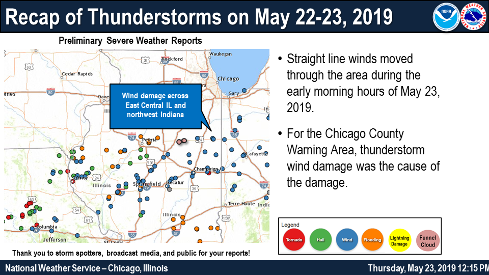 Preliminary Storm Reports |
Photos & Video
Header
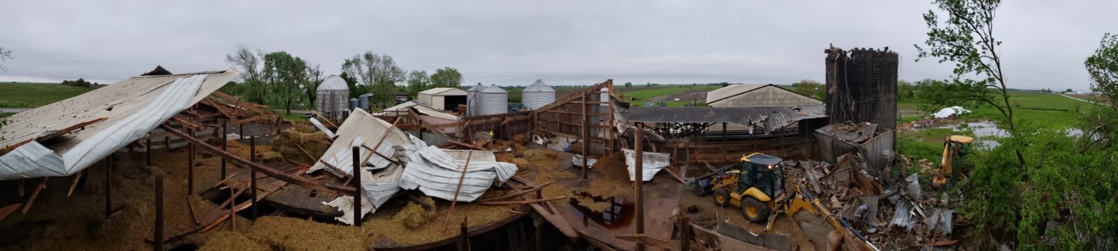 |
| Approximately 4 miles southwest of Cissna Park, IL (picture provided by Goodwine Coop) |
Radar
Header
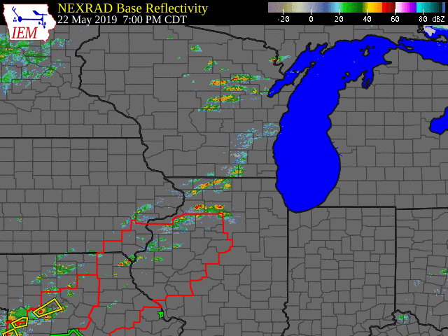 |
| Radar Image |
Storm Reports
PRELIMINARY LOCAL STORM REPORT...SUMMARY
NATIONAL WEATHER SERVICE CHICAGO IL
1239 PM CDT THU MAY 23 2019

..TIME...   ...EVENT...      ...CITY LOCATION...     ...LAT.LON...
..DATE...   ....MAG....      ..COUNTY LOCATION..ST.. ...SOURCE....
            ..REMARKS..

0244 AM     TSTM WND DMG     1 SSE WHEATFIELD        41.17N 87.05W
05/23/2019                   JASPER             IN   AMATEUR RADIO

            TREES DOWN NEAR 1100 W AND RT 49.

0244 AM     TSTM WND DMG     3 S WHEATFIELD          41.14N 87.05W
05/23/2019                   JASPER             IN   AMATEUR RADIO

            TREES DOWN NEAR 900W AND RT 49.

0244 AM     TSTM WND GST     WHEATFIELD              41.20N 87.05W
05/23/2019  M67 MPH          JASPER             IN   AMATEUR RADIO


0235 AM     TSTM WND GST     2 WNW RENSSELAER        40.95N 87.18W
05/23/2019  M61 MPH          JASPER             IN   AWOS

            AWOS STATION KRZL RENSSELAER AIRPORT.

0232 AM     TSTM WND GST     3 NE BEVERLY SHORES     41.73N 86.93W
05/23/2019  M51 MPH          LMZ745             IN   C-MAN STATION

            MICHIGAN CITY C-MAN STATION.

0230 AM     TSTM WND DMG     3 N OXFORD              40.57N 87.26W
05/23/2019                   BENTON             IN   EMERGENCY MNGR

            GRAIN BIN WAS BLOWN OVER AND BLOWN SEVERAL
            YARDS.

0220 AM     TSTM WND GST     KENTLAND                40.77N 87.45W
05/23/2019  M63 MPH          NEWTON             IN   BROADCAST MEDIA


0204 AM     TSTM WND GST     WATSEKA                 40.78N 87.73W
05/23/2019  M83 MPH          IROQUOIS           IL   AMATEUR RADIO

            MEASURED IN THE NORTHEAST PART OF THE CITY.

0203 AM     TSTM WND DMG     1 NW WATSEKA            40.78N 87.75W
05/23/2019                   IROQUOIS           IL   LAW ENFORCEMENT

            REPORTS FROM WATSEKA AUXILLARY POLICE OF
            NUMEROUS TREES, POWERLINES, AND TELEPHONE
            POLES DOWN NEAR AND NW OF US ROUTE 24. ROADS
            ARE BEING BLOCKED OFF. TIME ESTIMATED FROM
            RADAR.

0202 AM     TSTM WND DMG     2 NW WATSEKA            40.79N 87.76W
05/23/2019                   IROQUOIS           IL   CO-OP OBSERVER

            FLAG POLE FELL DOWN UPON VEHICLE.

0150 AM     TSTM WND DMG     4 SW CISSNA PARK        40.53N 87.96W
05/23/2019                   IROQUOIS           IL   PUBLIC

            NUMEROUS BUILDINGS ON FARMSTEAD DESTROYED BY
            WINDS. TIME OF OCCURRENCE ESTIMATED OFF OF
            RADAR.

0147 AM     TSTM WND GST     3 NE PIPER CITY         40.79N 88.15W
05/23/2019  M70 MPH          FORD               IL   PUBLIC

            REPORTED AT 2667 N 1700E RD, PIPER CITY, IL
            60959. STUCKEY FARMS.

0130 AM     TSTM WND DMG     GIBSON CITY             40.47N 88.37W
05/23/2019                   FORD               IL   BROADCAST MEDIA

            LARGE TREE DOWN ON LOTT BLVD IN GIBSON CITY.
            POWER OUT ACROSS THE TOWN. LOTS OF OTHER
            LIMBS DOWN. TIME ESTIMATED FROM RADAR.

1256 AM     FUNNEL CLOUD     FAIRBURY                40.74N 88.51W
05/23/2019                   LIVINGSTON         IL   LAW ENFORCEMENT

            NEAR ROUTE 24.


&&

$$
Additional Information
Summaries from other NWS Offices
 |
Media use of NWS Web News Stories is encouraged! Please acknowledge the NWS as the source of any news information accessed from this site. |
|

