
Scattered thunderstorms with severe gusts, hail and a tornado risk are possible near a cold front from the Ohio Valley to the Mid-Atlantic tonight. Tropical Storm Bertha is expected to bring tropical storm conditions to portions of the Gulf Coast from the panhandle of Florida into Louisiana through Wednesday. Read More >
| Wind Whips West Texas 23 February 2019 |
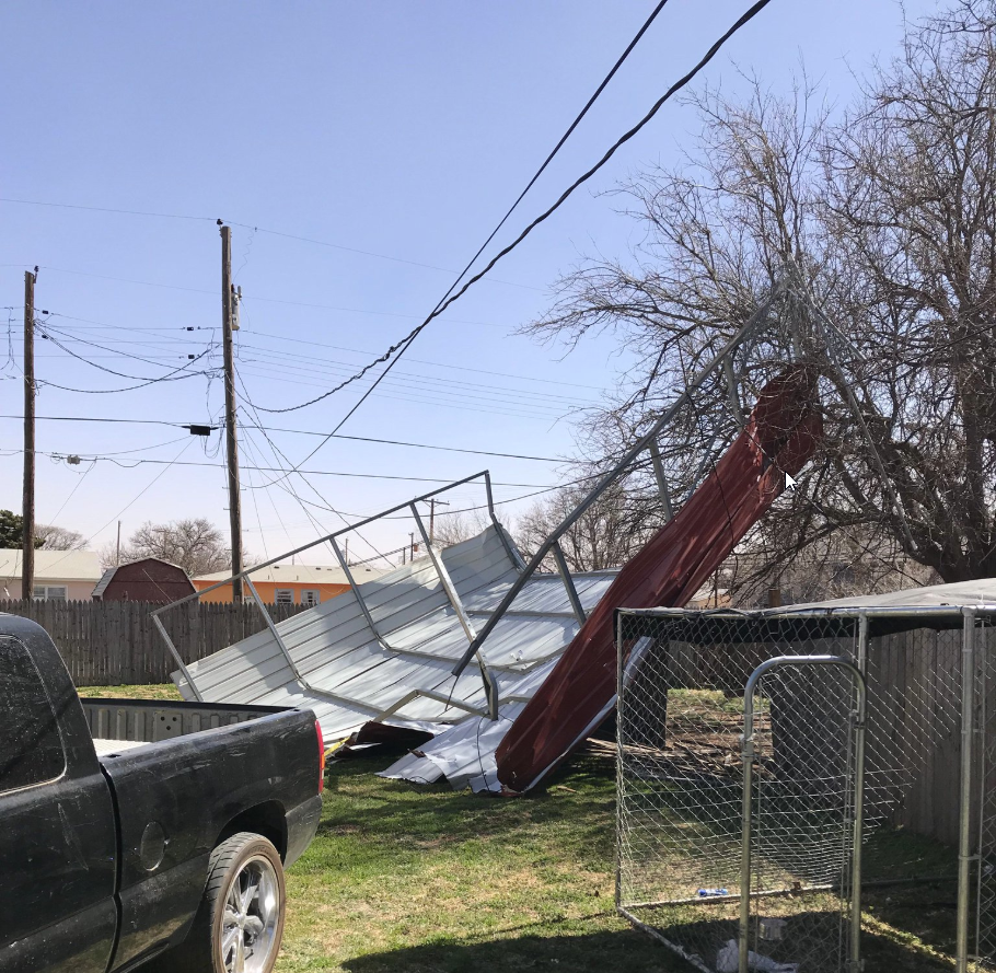 |
| Carport damage caused by strong winds in Lubbock on Saturday, 23 February 2019. The picture is courtesy of the City of Lubbock. |
| A powerful upper level storm system brought intense winds to the southern High Plains on Saturday, February 23rd. This system, the same that dumped feet of snow over the higher terrain of the Desert Southwest and southern Rockies, provided widespread westerly winds sustained at 35 to 50 mph, with gusts of 50 to 64 mph. |
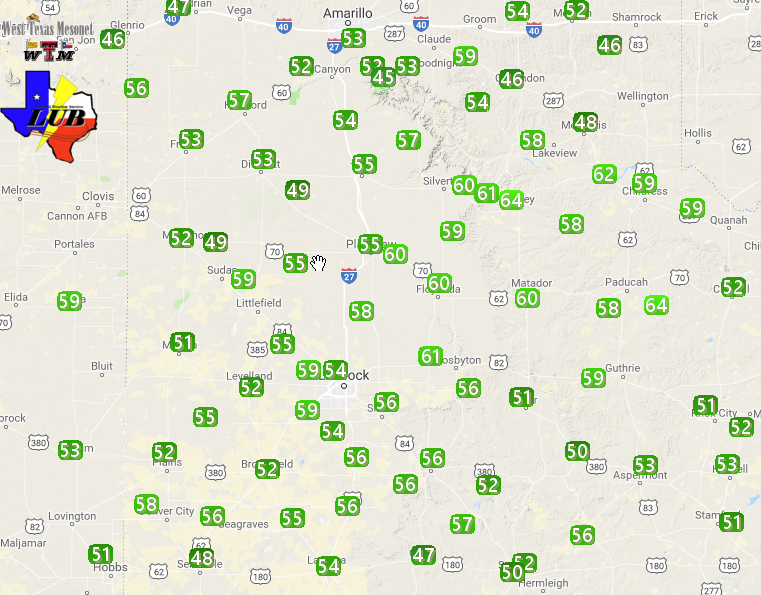 |
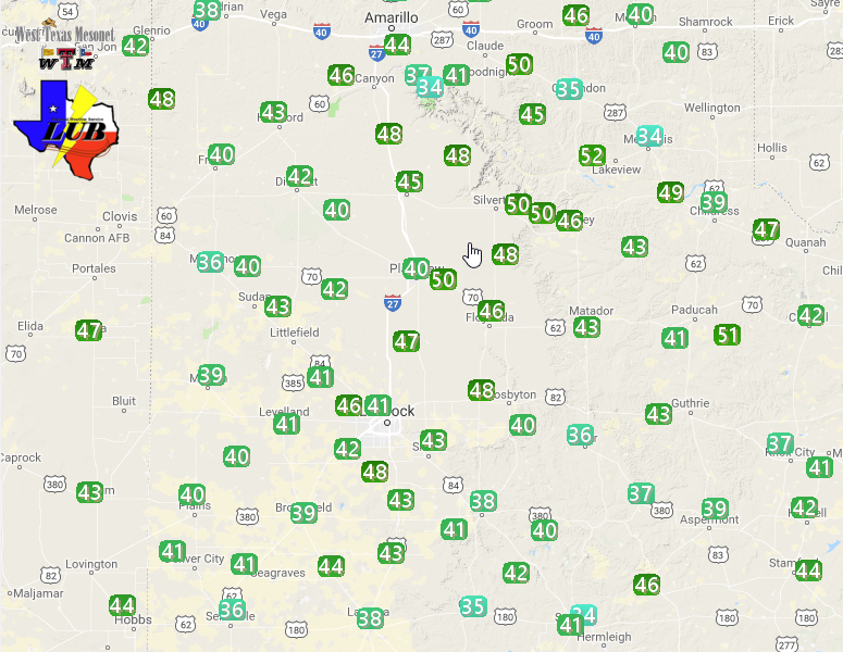
| Maximum wind gusts measured by the West Texas Mesonet on 23 February 2019. The maximum sustained wind speeds can be VIEWED HERE. |
| The strong and severe wind gusts did cause minor damage around the region, including destroying a carport in Lubbock. Officially, the Lubbock Preston Smith International Airport recorded a peak wind gust of 63 mph at 10:16 am. Similarly, Childress' official peak gust was also 63 mph, observed at 11:20 am. |
 |
| Infrared satellite animation valid from 9:42 am to 11:17 am on Saturday, 23 February 2019. |
| The above satellite imagery shows the powerful storm system emerging into the Great Plains around the time the peak wind gusts were occurring across the South Plains region. At the same time, this winter storm was producing blizzard conditions from the Oklahoma Panhandle through western Kansas into Nebraska. |
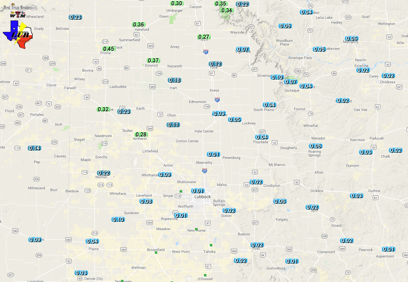
| Before the wind on Saturday, scattered showers and thunderstorms did affect West Texas late Friday night into the predawn hours of Saturday. The bulk of the rain fell across the western South Plains into the southwest Texas Panhandle, where a tenth to quarter inch of rain was common. The biggest winners were Muleshoe, Friona and Dimmitt where a third to half inch of rain fell. The rain even changed to snow toward the end of the event, with light accumulations noted in parts of Bailey and Parmer Counties. |
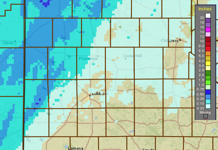 |
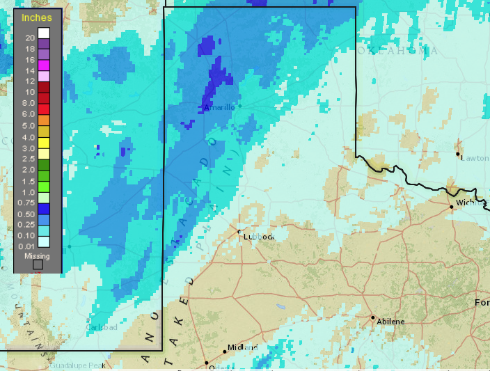
| 24-hour radar-estimated and bias-corrected rainfall ending at 11 am on 23 February 2019. A regional view of this same information can be FOUND HERE. Observed rain totals from the West Texas Mesonet can also be VIEWED HERE. |
| Below is another picture of damage observed in Lubbock on February 23rd. |
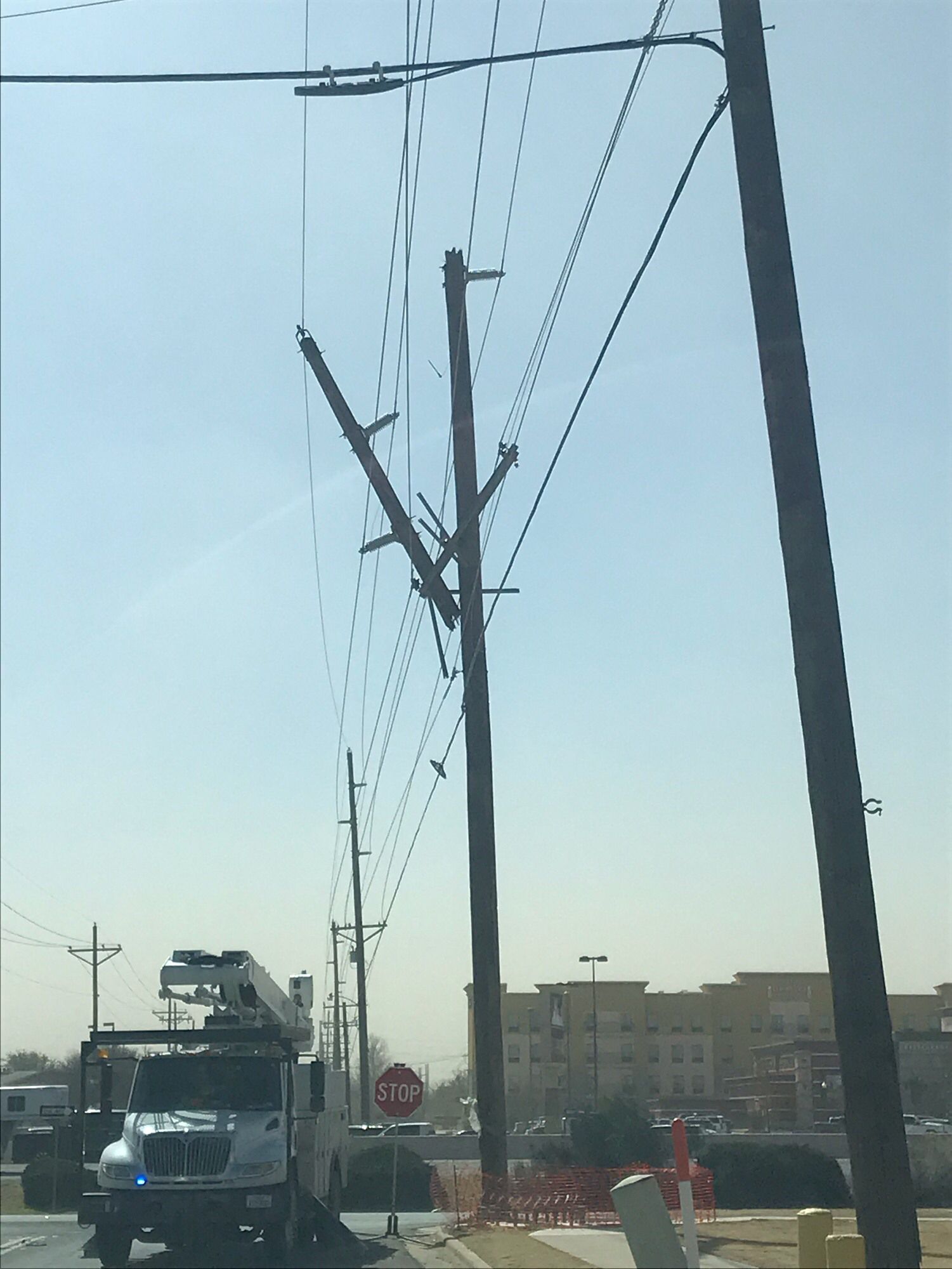 |
| Power line damage caused by strong winds in Lubbock on Saturday, 23 February 2019. The picture is courtesy of the City of Lubbock. |
| The Preliminary Storm Reports for this wind event are available below. |
PRELIMINARY LOCAL STORM REPORT...SUMMARY
NATIONAL WEATHER SERVICE LUBBOCK TX
451 PM CST SAT FEB 23 2019

..TIME...   ...EVENT...      ...CITY LOCATION...     ...LAT.LON...
..DATE...   ....MAG....      ..COUNTY LOCATION..ST.. ...SOURCE....
            ..REMARKS..

0300 AM     NON-TSTM WND GST 7 WNW DENVER CITY       32.99N 102.94W
02/23/2019  M58 MPH          YOAKUM             TX   MESONET

            MEASURED BY THE TTU WEST TEXAS MESONET

0937 AM     NON-TSTM WND GST CAPROCK CANYON SP       34.41N 101.06W
02/23/2019  M58 MPH          BRISCOE            TX   MESONET

            WEST TEXAS MESONET

0945 AM     NON-TSTM WND GST 2 W CHILDRESS           34.43N 100.28W
02/23/2019  M61 MPH          CHILDRESS          TX   ASOS

1000 AM     NON-TSTM WND GST 2 NNE FLOYDADA          34.00N 101.33W
02/23/2019  M59 MPH          FLOYD              TX   MESONET

            WEST TEXAS MESONET

1000 AM     NON-TSTM WND GST 5 ENE ABERNATHY         33.88N 101.76W
02/23/2019  M58 MPH          HALE               TX   MESONET

            WEST TEXAS MESONET

1014 AM     NON-TSTM WND GST 3 WSW AIKEN             34.13N 101.57W
02/23/2019  M60 MPH          HALE               TX   MESONET

            MEASURED BY THE WEST TEXAS MESONET

1015 AM     NON-TSTM WND GST 2 SSE HACKBERRY         33.90N 100.13W
02/23/2019  M59 MPH          COTTLE             TX   MESONET

            WEST TEXAS MESONET

1015 AM     NON-TSTM WND GST 7 ESE SILVERTON         34.45N 101.19W
02/23/2019  M58 MPH          BRISCOE            TX   MESONET

            WEST TEXAS MESONET

1016 AM     NON-TSTM WND GST 6 NNE LUBBOCK           33.67N 101.82W
02/23/2019  M63 MPH          LUBBOCK            TX   ASOS

1025 AM     NON-TSTM WND GST 6 SSW WOLFFORTH         33.42N 102.05W
02/23/2019  M59 MPH          LUBBOCK            TX   MESONET

            WEST TEXAS MESONET

1030 AM     NON-TSTM WND GST 2 WSW TURKEY            34.38N 100.93W
02/23/2019  M59 MPH          HALL               TX   MESONET

            WEST TEXAS MESONET

1030 AM     NON-TSTM WND GST REESE CENTER            33.61N 102.05W
02/23/2019  M59 MPH          LUBBOCK            TX   MESONET

            MEASURED BY THE WEST TEXAS MESONET

1040 AM     NON-TSTM WND GST 1 NE AMHERST            34.02N 102.40W
02/23/2019  M59 MPH          LAMB               TX   MESONET

            WEST TEXAS MESONET

1040 AM     NON-TSTM WND GST 2 WSW TURKEY            34.38N 100.93W
02/23/2019  M64 MPH          HALL               TX   MESONET

            MEASURED BY THE WEST TEXAS MESONET

1040 AM     NON-TSTM WND GST 2 NNE FLOYDADA          34.00N 101.33W
02/23/2019  M60 MPH          FLOYD              TX   MESONET

            MEASURED BY THE WEST TEXAS MESONET

1043 AM     NON-TSTM WND GST 2 SSE HACKBERRY         33.90N 100.13W
02/23/2019  M64 MPH          COTTLE             TX   MESONET

            MEASURED BY THE WEST TEXAS MESONET

1045 AM     NON-TSTM WND GST 3 N ROARING SPRINGS     33.94N 100.85W
02/23/2019  M60 MPH          MOTLEY             TX   MESONET

            WEST TEXAS MESONET

1050 AM     NON-TSTM WND GST 3 SSE ESTELLINE         34.50N 100.42W
02/23/2019  M62 MPH          HALL               TX   MESONET

            WEST TEXAS MESONET

1050 AM     NON-TSTM WND GST 1 SE RALLS              33.67N 101.38W
02/23/2019  M61 MPH          CROSBY             TX   MESONET

            WEST TEXAS MESONET

1050 AM     NON-TSTM WND GST 2 NNE CHILDRESS         34.46N 100.20W
02/23/2019  M59 MPH          CHILDRESS          TX   MESONET

            MEASURED BY THE WEST TEXAS MESONET

1055 AM     NON-TSTM WND GST 10 WSW GUTHRIE          33.57N 100.48W
02/23/2019  M58 MPH          KING               TX   MESONET

            WEST TEXAS MESONET

1101 AM     NON-TSTM WND DMG 3 SW LUBBOCK            33.55N 101.91W
02/23/2019                   LUBBOCK            TX   EMERGENCY MNGR

            TREES BLOWN DOWN KNOCKING DOWN POWERLINES. OTHER
            SPORADIC DAMAGE ACROSS THE CITY.

1102 AM     NON-TSTM WND GST 3 ENE SOUTH PLAINS      34.24N 101.26W
02/23/2019  M59 MPH          FLOYD              TX   MESONET

            MEASURED BY THE WEST TEXAS MESONET

1105 AM     NON-TSTM WND GST 10 WSW GUTHRIE          33.57N 100.48W
02/23/2019  M59 MPH          KING               TX   MESONET

            MEASURED BY WEST TEXAS MESONET

1130 AM     NON-TSTM WND GST 10 SW PADUCAH           33.89N 100.40W
02/23/2019  M58 MPH          COTTLE             TX   MESONET

            WEST TEXAS MESONET

1140 AM     NON-TSTM WND GST 1 S NORTHFIELD          34.27N 100.60W
02/23/2019  M58 MPH          MOTLEY             TX   MESONET

            MEASURED BY THE WEST TEXAS MESONET

1150 AM     NON-TSTM WND GST 7 ESE SILVERTON         34.45N 101.19W
02/23/2019  M60 MPH          BRISCOE            TX   MESONET

            MEASURED BY THE WEST TEXAS MESONET

1150 AM     NON-TSTM WND GST CAPROCK CANYON SP       34.41N 101.06W
02/23/2019  M61 MPH          BRISCOE            TX   MESONET

            MEASURED BY THE WEST TEXAS MESONET

1241 PM     NON-TSTM WND GST 2 S LESLEY              34.65N 100.81W
02/23/2019  M58 MPH          HALL               TX   MESONET

            MEASURED BY THE WEST TEXAS MESONET

