
Scattered thunderstorms with severe gusts, hail and a tornado risk are possible near a cold front from the Ohio Valley to the Mid-Atlantic tonight. Tropical Storm Bertha is expected to bring tropical storm conditions to portions of the Gulf Coast from the panhandle of Florida into Louisiana through Wednesday. Read More >
| Large hail and torrential rain fall in Lubbock and nearby communities 24 June 2019 |
|
 |
|
| Hail that fell near 82nd Street and Martin Luther King Jr. Avenue in Lubbock on Monday evening (24 June 2019). The picture is courtesy of Dee Murdock and Nick Kraynok. | |
| A returning warm front brought an increase in heat and humidity through the day on Monday, June 24th. This combination resulted in the development of strong instability that would fuel intense thunderstorms by the evening across the South Plains. | |
 |
|
| Lubbock WSR-88D loop valid from 6:36 pm to 8:13 pm on 24 June 2019. Regional radar animation this evening can be found at: 5:08 pm to 6:18 pm on 24 June; and 8:18 pm to 9:28 pm on 24 June. | |
| Scattered strong and severe thunderstorms initially developed over the Permian Basin during the afternoon hours. One of these thunderstorms, an anticyclonic supercell, raced northward into the south-central South Plains during the evening. In advance of this storm, another storm developed over Lubbock and quickly became severe before splitting into two storms, one which moved northeast and another that moved southeast. Both storms became very intense, throwing baseball size hail and larger. | |
 |
|
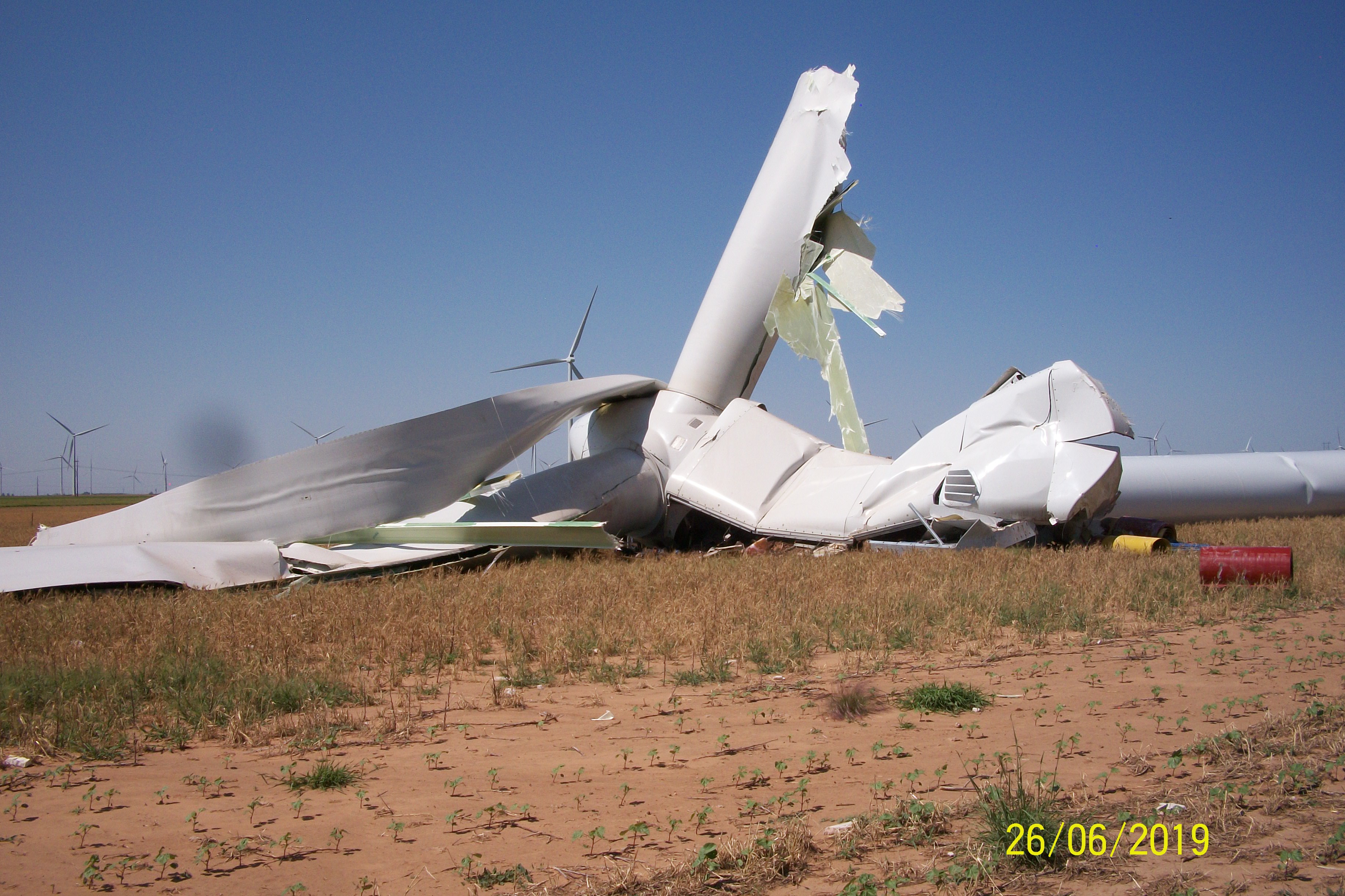
| The Monday evening storm downed a wind turbine near Petersburg. The picture was taken by David Hipolito. | |
| The largest hail, baseball to softball size, fell southwest of Tahoka, in Wilson, in Slaton and east of New Deal. Many other locations in and around Lubbock recorded quarter to golf ball size hail during several rounds of hail. The north-most storm also generated very strong winds and toppled a newly installed wind turbine near Petersburg. | |
 |
 |
| Large hail that fell in New Deal (left) and Wilson (right) on Monday evening. The pictures are courtesy of Jacob Riley and Eddie Castanon (right). | |
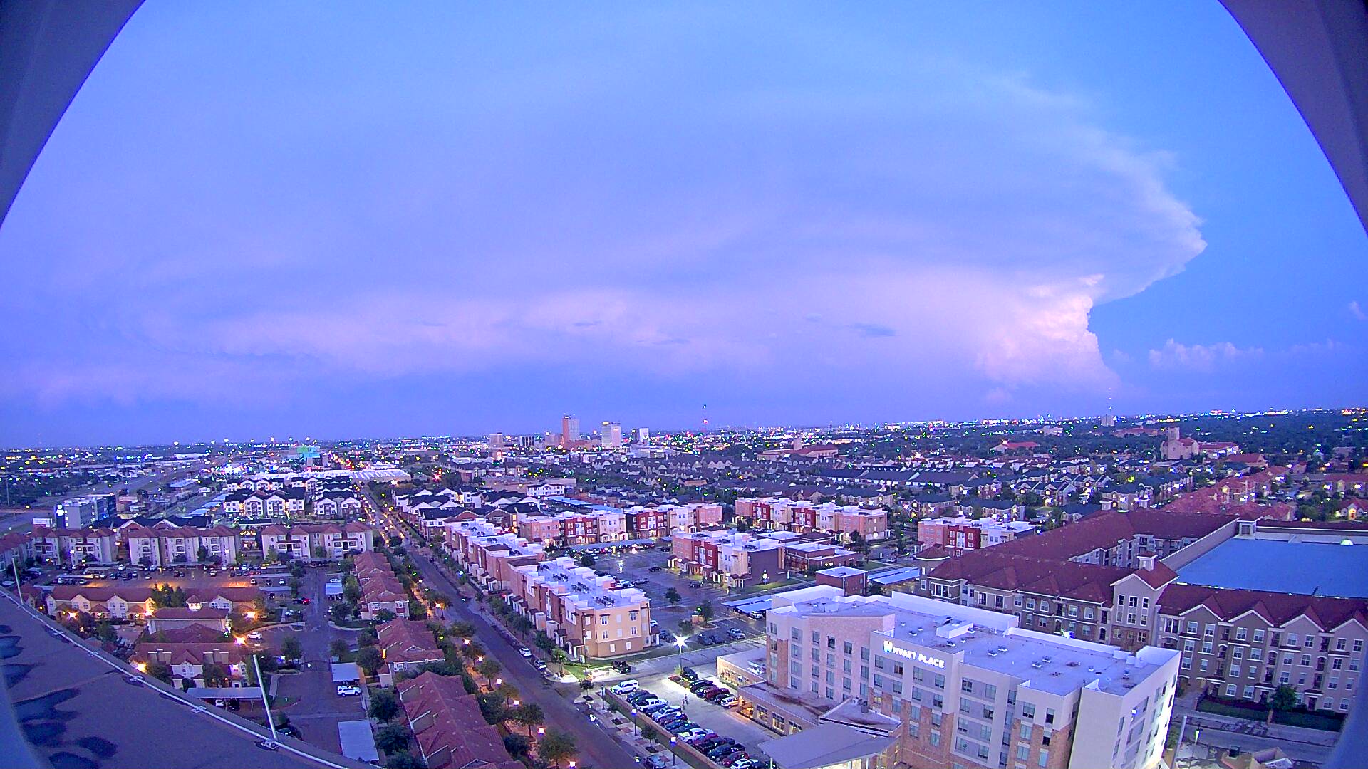
| As the storms moved away from Lubbock, the setting sun did make for a picturesque sky, though the damage was done. | |
 |
|
| Picture captured from the Overton in Lubbock just after sunset Monday, 24 June 2019. The view of the departing severe thunderstorm is courtesy of KAMC. | |
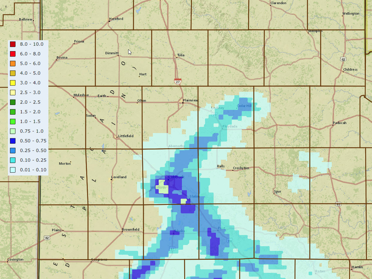
| Not to be forgotten, the slow moving and merging storms over Lubbock produced torrential rainfall in spots. The heaviest rain was concentrated over the southern part of Lubbock. The National Weather Service Office, located in the Science Spectrum, recorded 2.08 inches of rain, most of which fell in less than an hour. This resulted in extensive street flooding. The heaviest rain was relatively limited though, as the official observation located at the airport on the north side of town only recorded two tenth of an inch of rain. | |
 |
|
| 24-hour radar-estimated and bias-corrected precipitation, ending at 7 am on 25 June 2019. | |
| A listing of the preliminary storm reports for this active Monday evening can be found below. | |
PRELIMINARY LOCAL STORM REPORT...SUMMARY
NATIONAL WEATHER SERVICE LUBBOCK TX
203 AM CDT TUE JUN 25 2019

..TIME...   ...EVENT...      ...CITY LOCATION...     ...LAT.LON...
..DATE...   ....MAG....      ..COUNTY LOCATION..ST.. ...SOURCE....
            ..REMARKS..

0625 PM     HAIL             7 SW TAHOKA             33.09N 101.88W
06/24/2019  E2.75 INCH       LYNN               TX   EMERGENCY MNGR

0650 PM     HAIL             7 SW LUBBOCK            33.50N 101.96W
06/24/2019  E1.50 INCH       LUBBOCK            TX   NWS EMPLOYEE

0650 PM     HAIL             5 SW LUBBOCK            33.52N 101.95W
06/24/2019  E1.50 INCH       LUBBOCK            TX   NWS EMPLOYEE

0655 PM     HAIL             3 WSW LUBBOCK SOUTH PLA 33.52N 101.97W
06/24/2019  M1.25 INCH       LUBBOCK            TX   SOCIAL MEDIA

            SLIGHTLY LARGER THAN HALF DOLLAR HAIL NEAR QUINCY AND
            82ND STREET IN LUBBOCK

0658 PM     HAIL             TAHOKA                  33.16N 101.79W
06/24/2019  E1.75 INCH       LYNN               TX   TRAINED SPOTTER

0658 PM     HAIL             LUBBOCK                 33.58N 101.88W
06/24/2019  E1.25 INCH       LUBBOCK            TX   PUBLIC

            REPORTED ON THE 5500 BLOCK OF 100TH ST. IN LUBBOCK.

0702 PM     HAIL             8 W LUBBOCK             33.58N 102.01W
06/24/2019  E1.75 INCH       LUBBOCK            TX   TRAINED SPOTTER

            GOLFBALL SIZE HAIL REPORTED BY NWS EMPLOYEE AT
            MILWAUKEE AND 43RD.

0714 PM     HAIL             2 SSE BROADVIEW         33.61N 101.91W
06/24/2019  M1.00 INCH       LUBBOCK            TX   SOCIAL MEDIA

            HAIL RANGING FROM DIME TO SLIGHTLY LARGER THAN QUARTER
            AT ERSKINE AND NORTH LOOP 289 IN LUBBOCK

0720 PM     HAIL             WILSON                  33.32N 101.73W
06/24/2019  E3.00 INCH       LYNN               TX   SOCIAL MEDIA

            LARGE HAIL NOTED ON SOCIAL MEDIA.

0720 PM     HAIL             1 NNW WEST END PLACE    33.59N 101.96W
06/24/2019  M1.25 INCH       LUBBOCK            TX   SOCIAL MEDIA

            QUARTER TO HALF DOLLAR SIZE HAIL MEASURED AT 4TH STREET
            AND MILWAUKEE AVENUE

0721 PM     HAIL             TEXAS TECH UNIV.        33.58N 101.86W
06/24/2019  E1.00 INCH       LUBBOCK            TX   SOCIAL MEDIA

            ONE INCH HAIL AT CARPENTER WELLS RESIDENCE HALL

0722 PM     HAIL             LUBBOCK                 33.58N 101.88W
06/24/2019  E1.50 INCH       LUBBOCK            TX   TRAINED SPOTTER

            KLBB OBSERVER REPORTS PING PONG SIZE HAIL AT THE
            AIRPORT.

0725 PM     HAIL             3 SSE LUBBOCK           33.53N 101.86W
06/24/2019  M1.00 INCH       LUBBOCK            TX   SOCIAL MEDIA

            HAIL NEAR SOUTH LOOP 289 AND AVENUE U

0725 PM     TSTM WND DMG     4 SSW LUBBOCK           33.53N 101.88W
06/24/2019                   LUBBOCK            TX   NWS OFFICE

            LARGE TREE BRANCH BROKEN OFF INTO PARKING LOT OF NWS
            OFFICE

0730 PM     HAIL             2 SSW LUBBOCK SOUTH PLA 33.50N 101.93W
06/24/2019  E1.50 INCH       LUBBOCK            TX   PUBLIC

            PING PONG SIZE HAIL NEAR 98TH STREET AND CHICAGO IN
            LUBBOCK.

0732 PM     HAIL             LUBBOCK                 33.58N 101.88W
06/24/2019  E1.00 INCH       LUBBOCK            TX   EMERGENCY MNGR

            QUARTER SIZE HAIL REPORTED AT 62ND ST AND KNOXVILLE.

0735 PM     HAIL             BUFFALO SPRINGS         33.53N 101.71W
06/24/2019  E1.50 INCH       LUBBOCK            TX   TRAINED SPOTTER

0739 PM     HAIL             SLATON                  33.44N 101.64W
06/24/2019  E2.75 INCH       LUBBOCK            TX   TRAINED SPOTTER

            BASEBALL SIZE HAIL AT SLATON AIRPORT.

0745 PM     HAIL             3 NW WOODROW            33.48N 101.88W
06/24/2019  E1.75 INCH       LUBBOCK            TX   NWS EMPLOYEE

0745 PM     HAIL             LUBBOCK                 33.58N 101.88W
06/24/2019  E1.00 INCH       LUBBOCK            TX   PUBLIC

            QUARTER SIZE HAIL REPORTED AT QUAKER AND 114TH ST.

0750 PM     HAIL             NEW DEAL                33.73N 101.84W
06/24/2019  M2.75 INCH       LUBBOCK            TX   SOCIAL MEDIA

            TWITTER PICTURE OF MEASURED HAIL 2.75" IN DIAMETER

0755 PM     HAIL             3 W BURRIS              33.52N 101.82W
06/24/2019  E2.75 INCH       LUBBOCK            TX   SOCIAL MEDIA

            PICTURE VIA SOCIAL MEDIA

0759 PM     HAIL             7 E NEW DEAL            33.73N 101.72W
06/24/2019  E3.00 INCH       LUBBOCK            TX   TRAINED SPOTTER

0801 PM     HAIL             1 NE DOUD               33.56N 101.92W
06/24/2019  M1.00 INCH       LUBBOCK            TX   SOCIAL MEDIA

            QUARTER SIZE HAIL AT 34TH AND SLIDE VIA SOCIAL MEDIA

0826 PM     TSTM WND DMG     9 NW PETERSBURG         33.96N 101.71W
06/24/2019                   HALE               TX   SOCIAL MEDIA

            DESTROYED WIND TURBINE RELAYED THROUGH SOCIAL MEDIA.
            TIME ESTIMATED FROM RADAR, PEAK WIND ON LOWEST SCAN 80
            MPH.

0833 PM     HAIL             PETERSBURG              33.87N 101.60W
06/24/2019  E2.75 INCH       HALE               TX   LAW ENFORCEMENT

