The year 2023 was very active, particularly through early August. While the region witnessed one of our warmest winters on record, we still managed a couple impactful wintry precipitation events during the last week of January. March roared in like a lion with a powerful storm system that led to severe thunderstorms, tornadoes, flooding, strong gradient winds of 50-70 mph, and the lowest barometric pressure on record in Paducah and Evansville. We witnessed an incredibly high number of windy days during the first several months. Our office ended up issuing a total of 12 wind advisories from January through April (records for wind advisories date back to 2006 and this was 3 more than the previous highest during the first 4 months of the year which was 9 in 2019). During the overnight hours on April 5th, an EF-2 tornado touched down in Bollinger County Missouri and unfortunately took the lives of 5 people as it tore through the town of Glenallen.
An extremely active pattern set up from late June through early August with multiple rounds of severe thunderstorms and flash flooding. The first round arrived over the weekend leading up to the 4th of July, when we issued 154 combined warnings over a 4 day period (breaking the previous 4 day record of 148 warnings set from April 24-27, 2011). This was followed by a historic flash flooding event on July 19th that produced a swath of rainfall amounts of 6 to 11 inches. Numerous Flash Flood Emergencies were issued and the Graves County mesonet site broke the Kentucky state 24-hour precipitation record picking up an incredible 11.28". Yet another flash flooding event occurred in early August, this time focused slightly further west across southeast Missouri and far west Kentucky. Despite starting off the summer with drought conditions developing from late May through June, parts of the region ended up observing one of our wettest summers on record thanks to the insane rainfall totals from July 1 - August 15. Anomalously high soil moisture levels in August helped contribute to record high humidity levels (dewpoints in the low to mid 80s) which produced heat index readings as high as 120 during our week-long heat wave from August 20-26.
We finally got a much needed break from the active weather September through November, with drought conditions redeveloping across much of the region. Record low water levels were observed along portions of the Mississippi River from New Madrid down to Memphis in October. As we neared the end of the year, a severe weather event occurred on December 9th across southern portions of west Kentucky. An EF-2 tornado left a path of damage across Todd County, Kentucky (part of a 48 mile long track which included EF-3 damage in Clarksville, TN). The year ended with a combined 647 warnings (severe thunderstorm, tornado, and flash flood) which was the 2nd most on record for a year dating back to 1995 (the record is 709 warnings issued in 2006).
|
Review of top weather events in 2023 (in chronological order). CLICK ON IMAGES TO ENLARGE |
|||||
|
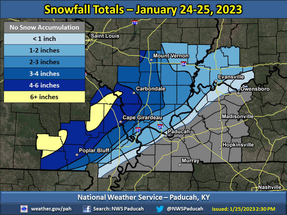
1. January 24-25 - Heavy wet snow across Missouri Ozark Foothills leads to widespread power outages
Image: Snowfall accumulations from January 24-25 |
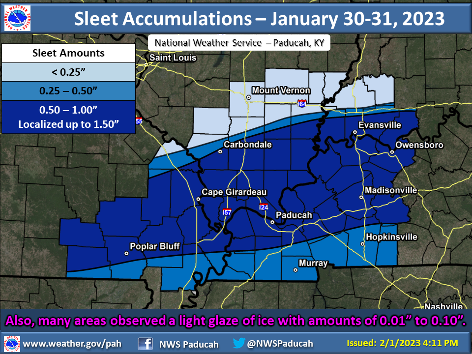
2. January 30-31 - Sleet and snow impact the region
Image: Sleet accumulations from January 30-31 |
||||
|
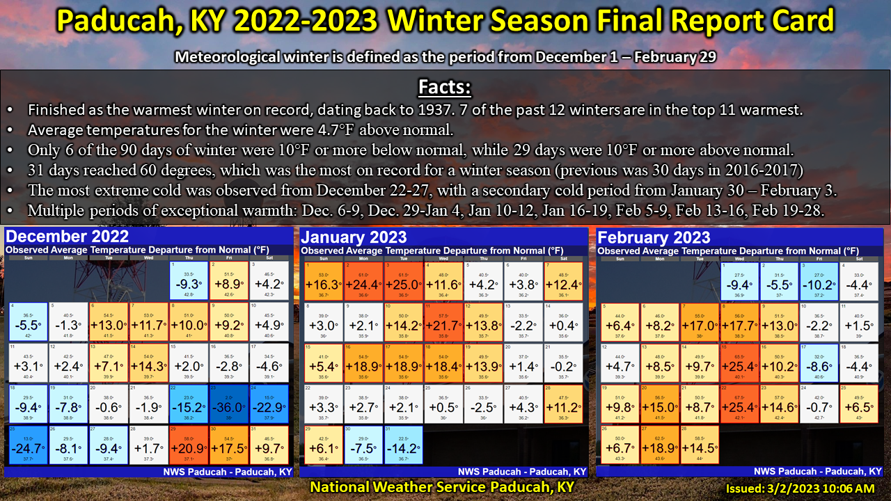
3. Dec 2022-Feb 2023 Warmest winter on record in Paducah and Cape Girardeau.
Image: Winter Season Daily Departures for Paducah, KY |
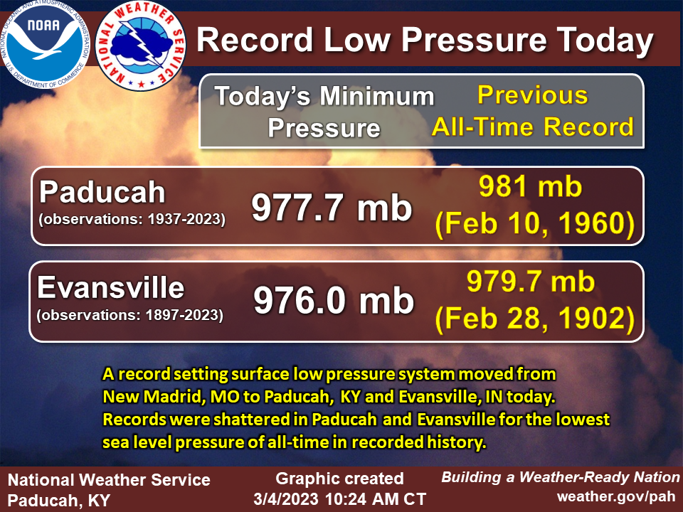
4. March 3 Tornadoes, flooding, strong gradient winds, and all-time lowest surface pressure
Image: Record low barometric pressure set in Paducah and Evansville |
||||
|
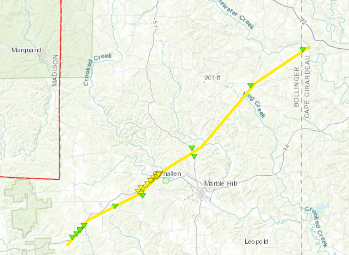
5. April 5 EF-2 tornado in Glenallen, MO causes 5 fatalities
Image: EF-2 Tornado track that went through Bollinger County MO |
6. June 29-July 2 Very active 4 day period with numerous rounds of severe thunderstorms. Total of 238 reports of large hail, damaging winds, or severe wind gusts across our area.
Image: Observed local storm reports over this 4 day period. |
||||
|
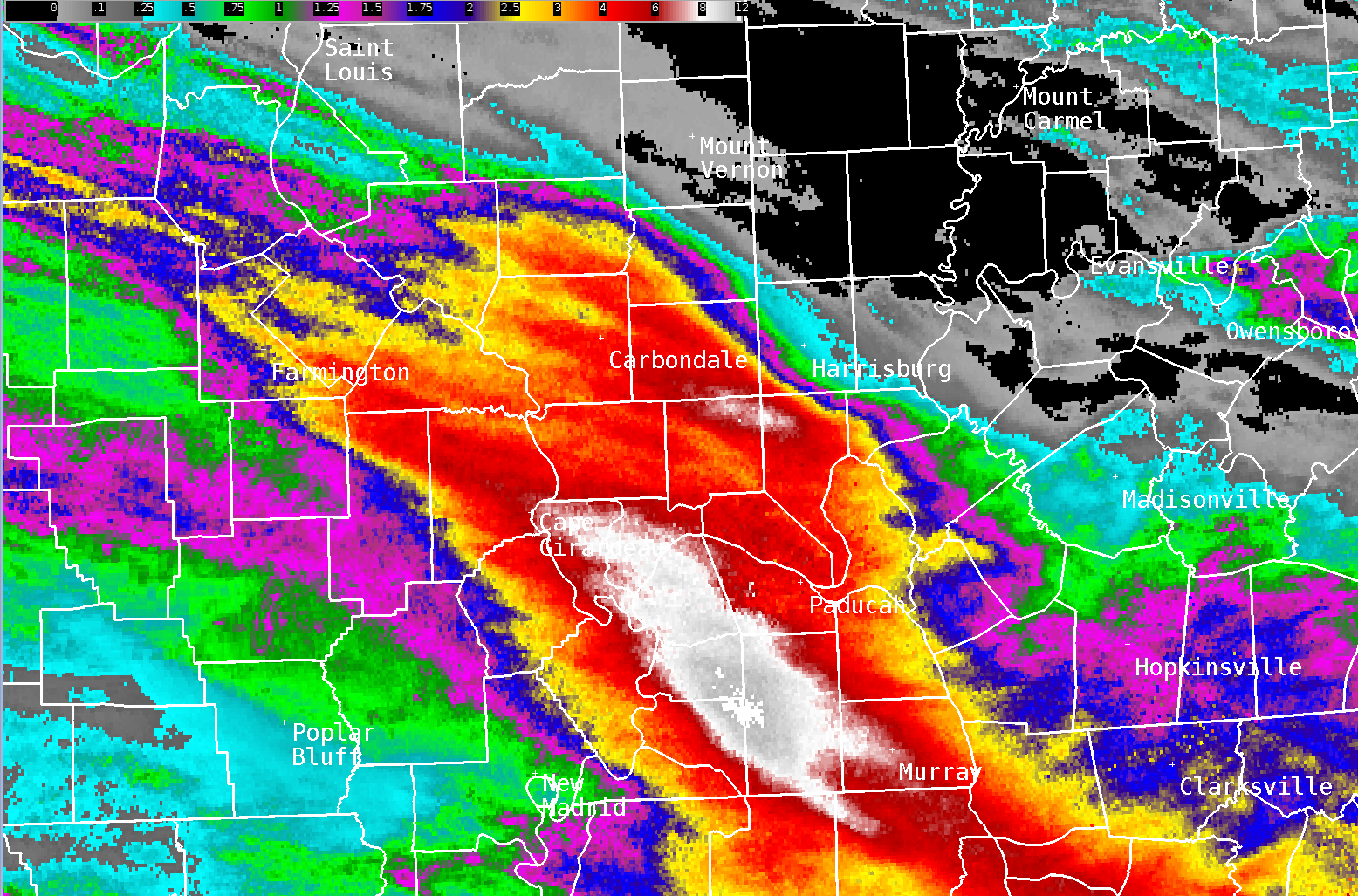
7. July 19 Historic flash flooding across portions of KY, IL, and MO. New 24-hour state record established in KY with 11.28" at the Graves County mesonet station.
Image: Rainfall accumulations from July 18-19 |
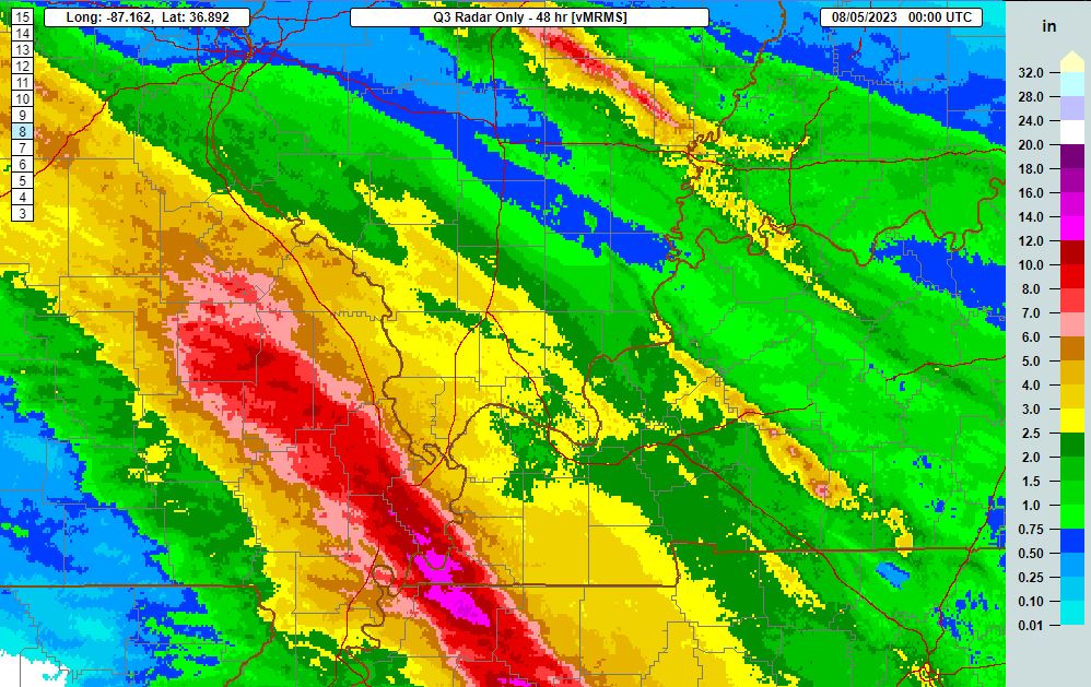
8. August 3-4 Flash flooding with hardest hit areas from Marble Hill to Sikeston, MO to Hickman, KY.
Image: Rainfall accumulations from August 3-4 |
||||
|
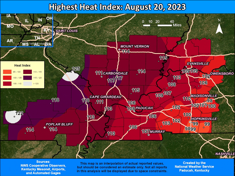
9. Aug 20-26 Hot temperatures and record high humidity levels lead to daily heat index readings of 105 to 120.
Image: Map of peak heat index readings each day August 20-26 |
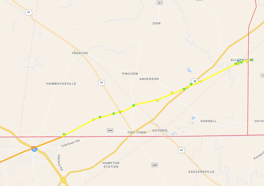
10. December 9 - EF-2 tornado in southern Todd County, Kentucky. Part of 47.75 mile long path with EF-3 damage in Clarksville, TN.
|
||||