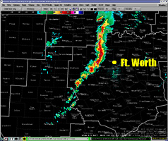
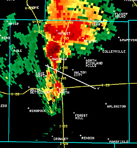
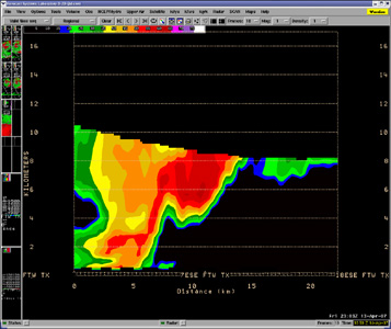
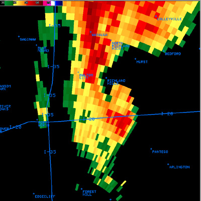
National Weather Service United States Department of Commerce

Severe Thunderstorm and Excessive Rain Expected in the Southeast and Hawaii

Severe thunderstorms and excessive rainfall threats continue in the Southeast through Friday. Heavy snow will continue over the higher elevations of the Central Rockies. A storm system moving over Hawaii will bring strong to severe thunderstorms, localized intense rainfall and flash flooding through Saturday. Above average high temperatures expected in California and the Pacific Northwest. Read More >


Greater Ft. Worth/Dallas Metroplex Tornadoes
April 13, 2007

Preliminary Public Information Statements and Track Maps


The ingredients for a Severe weather outbreak were in place on Friday, April 13, 2007, as moist, unstable air flowed northward ahead of a strong upper level system. This page gives a brief, radar-based overview of the supercell thunderstorm that produced tornadoes and very large hail across Tarrant and Dallas Counties. For details on the tornadoes that occurred in these areas, visit our web page linked above that has track maps and storm survey information.

The radar image to the right shows a line of storms developing northwest of Fort Worth at 512 PM CDT. The strongest storms extended from Montague and Wise Counties southward into Parker and Palo Pinto Counties. As the storms moved into Denton and Tarrant Counties, the southernmost cell across Tarrant County strengthened rapidly as a surge of warm, moist air moved into the metroplex.

The KFWS 88D radar image from 603 PM CDT shows an area of very high reflectivity near downtown Fort Worth and also near Saginaw. An area of very strong rotation was developing near an intense updraft in association with the high reflectivity near downtown Fort Worth. Large hail was likely occurring or developing near the high reflectivity core near Saginaw. The white line in the image is the location of a radar reflectivity cross section image shown below. 

Radar picture showing line of storms developing across western N. Texas.
Ft. Worth Radar Showing Line Of Storms 
Across N. Texas at 5:12 pm CDT.

Radar picture from Ft. Worth/Haltom City tornado
Reflectivity of SuperCell thunderstorm just North of Ft. Worth
Time is 6:03 pm cdt.

Radar cross section through storm that procueded tornado in Haltom City and Ft. Worth.
Reflectivity Cross Section of SuperCell Storms Weak Echo Region
Time is 6:03 pm cdt.


The radar cross section of the rapidly developing supercell storm has several noteworthy features. In the cross section, height values in kilometers are shown on either side of the image, and the horizontal map locations are shown at the bottom. The cross section shows a vertical profile of radar reflectivity at 603 PM CDT. Note the very high (60-65 dBZ) values of reflectivity above the ground around 6 km (20,000 feet), likely indicating large hail aloft being suspended by a very strong updraft. Also, a well-defined Bounded Weak Echo Region (BWER)  can be seen at about 8 km on the horizontal scale and at a 4-5 km height. The BWER is a radar indication of an intense updraft in the supercell thunderstorm. 


The radar imagery at 613 PM CDT shows a reflectivity "hook"  just north of Interstate 30 southeast of Richland Hills. The storm relative mean radial velocity image (SRM) at 613 PM shows a strong rotational signature, with red colors (representing wind flow AWAY from the radar) adjacent to green and blue colors (representing wind flow TOWARD the radar). 


radar picture showing tornadic signature over Haltom City.
Base Reflectivity at 6:13 pm CDT from Ft. Worth Radar

Radar velocity picture showing circulation around tornado in Haltom City.
Storm Relative Velocity at 6:13 pm CDT from Ft. Worth Radar


This dangerous supercell storm continued to move east during the evening, and generally moved on a track just north of and parallel to Interstate 30. The reflectivity imagery at 701 PM CDT shows an area of 65 dBZ values near Garland (likely associated with very large hail) and a reflectivity hook near Interstate 30 southwest of Garland. The SRM imagery at 701 PM CDT shows a strong circulation, likely associated with the brief tornado touchdown in this area. 


Radar Picture showing tornadic hook signature in east Dallas.
Base Reflectivity at 7:01 pm CDT from Ft. Worth Radar

radar velocity picture showing circulation in eastern Dallas
Storm Relative Velocity at 7:01 pm CDT from Ft. Worth Radar