
Scattered severe thunderstorms are possible today across central and eastern Minnesota, Iowa, and western Wisconsin. A few tornadoes, isolated very large hail, and damaging winds may occur. An upper level low will help trigger scattered thunderstorms over portions of central and southern California today along with a few inches of snow in the central Sierra Nevadas. Read More >
Summary | Forecasts | Snow and Wind Reports | Travel Center | Monitoring & Reporting | Safety
SYNOPSIS:
November 17, 2017 - A storm system will move through Wyoming tonight with colder air moving in from west to east. Scattered areas of snow showes will continue through the evening in the Western and Central mountains and valleys. Some of these snow showers may produce amounts up to another inch before the snow ends by later tonight. Roads may become slick to snow covered in places tonight.
|
|
|
|
|
|
|
|
High Wind Statement |
|
Multimedia Briefing |
 |
|
|
Click Image To Enlarge |
Summary | Forecast | Travel Center | Monitoring & Reporting | Safety
|
|
|
| Road Conditions and Web Cameras | |||
 |
|||
|
|
|
|
|
 |
 |
 |
 |
|
|
|
|
|
 |
|
 |
 |
|
|
|
|
|
 |
 |
 |
 |
|
|
|
|
|
 |
 |
 |
 |
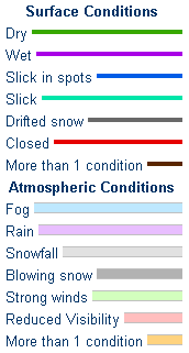
If you plan to travel, we recommend checking road conditions along your route and staying on top of road closures here. If you are on Twitter, follow the hashtag: #WyoRoad (or look below) for the latest weather affecting roads and road conditions in and around Wyoming.
| Tweets by @NWSRiverton | #WyoRoad Tweets |
|
Get the play-by-play on this storm and contribute your own snow reports to #wywx |
On the road? Tweet road conditions to #WyoRoad!
|

Summary | Forecast | Travel Center | Monitoring & Reporting | Safety
PLEASE SEND US YOUR SNOW REPORTS (CLICK HERE)
 |
Monitor our Severe Weather Summary Page for current Warnings, Watches, and Advisories. What's the difference? |
 |
Check the latest Weather Story graphic for an overview of the area forecast. |
 |
Check out what's on the radar. Riverton | Pocatello | Cheyenne | Billings | Salt Lake City | Rapid City | Mosaic |
| Submit storm reports/images and keep up to date with us on Facebook! | |
 |
Submit storm reports/images and keep up to date with us on Twitter! |
 |
Other reporting methods include submitting an online report, email (cr.wxriw@noaa.gov), or by phone at 1-800-211-1448. |
 |
Check the latest Public Information Statement for the latest storm reports. |
| Monitor current road conditions by visiting the Wyoming Dept. of Transportation (WYDOT) or by calling 5-1-1. |
Summary | Forecast | Travel Center | Monitoring & Reporting | Safety

Winter Safety Kit | Winter Weather Safety
 |
Learn more about the National Weather Service's efforts to build a Weather-Ready Nation! |


