National Weather Service United States Department of Commerce
Click a location below for detailed forecast.

Last Map Update: Sun, Nov 9, 2025 at 10:46:05 am MST

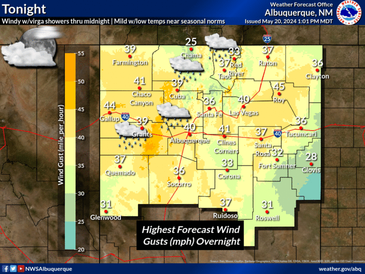
Temperatures will generally be near to above average through early next week, with highs reaching as many as 10-15 degrees above normal in several locations. A dry front will cool temperatures on Sunday, especially in eastern New Mexico where readings will drop below normal.
A strong cold front brings a sharp drop in high temperatures to the eastern half of NM today where highs will be about 10 to 15 degrees below average for this time of year. Forecast highs range from the 40s to 50s thru eastern NM, with 50s and 60s along and west of the Rio Grande Valley.
Dry weather is forecast through the next six days. Temperatures will generally run near to above average, with the exception being today in eastern New Mexico where a cold front will temporarily drop highs below normal.


Text Product Selector (Selected product opens in current window)


Submit Storm Report Icon

Submit Storm Report

Key Impacts Icon

Key Impacts

Observations Icon

Local Observations

Webcams Icon

Office Webcams

Satellite Icon

Satellite Imagery

Are You Prepared Icon

Are You Prepared?

Weekly Weather Briefing Icon

Weekly Weather Briefing

Area Forecast Discussion Icon

Area Forecast Discussion

Fire Weather Icon

Fire Weather

Aviation Weather Icon

Aviation Weather

Snow Probabilities Icon

Snow Probabilities

SKYWARN Icon

SKYWARN Spotters

On This Date in Weather History Icon

On This Date

Climate Graphs Icon

Climate Graphs

Drought Monitor Icon

Drought Monitor

Severe Weather Info and Climatology Icon

Severe Weather Climatology

Monsoon Awareness Icon

Monsoon Awareness

Winter Climatology Icon

Winter Climatology