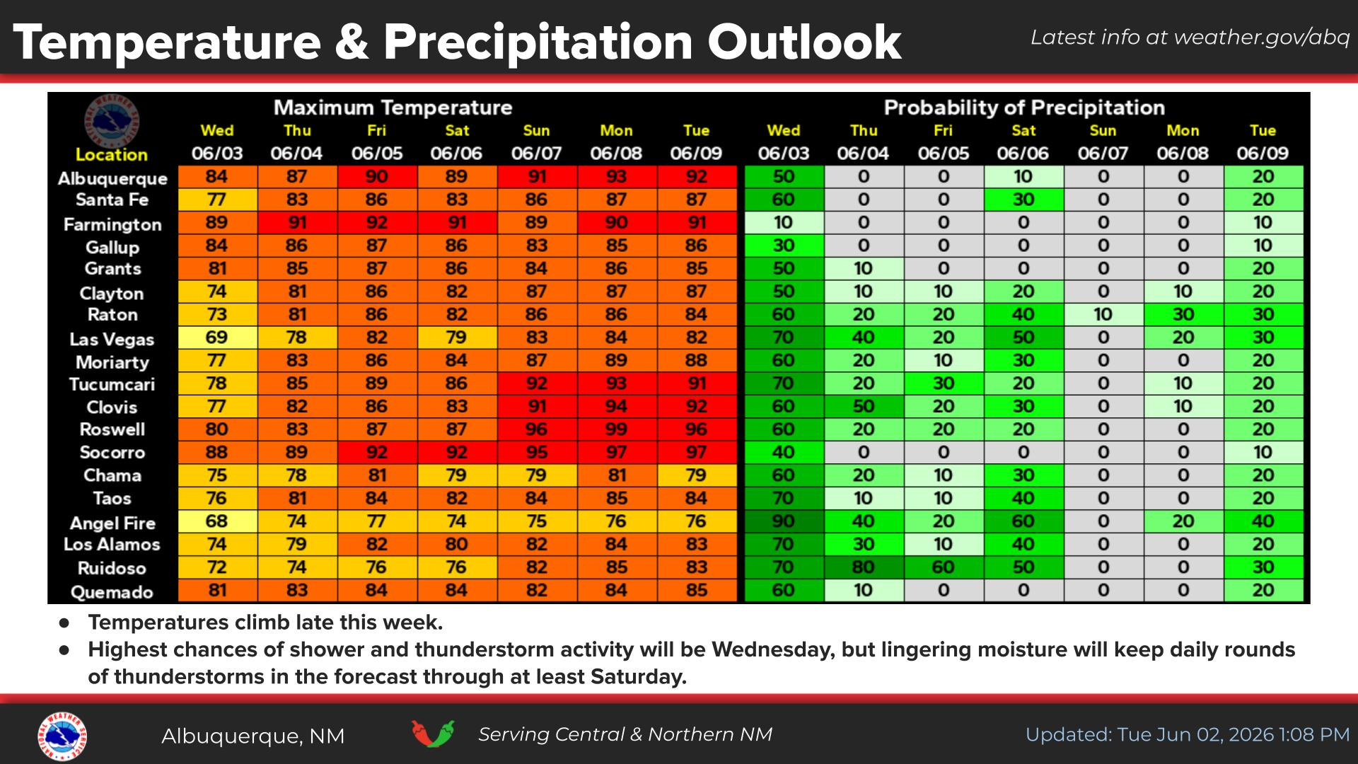
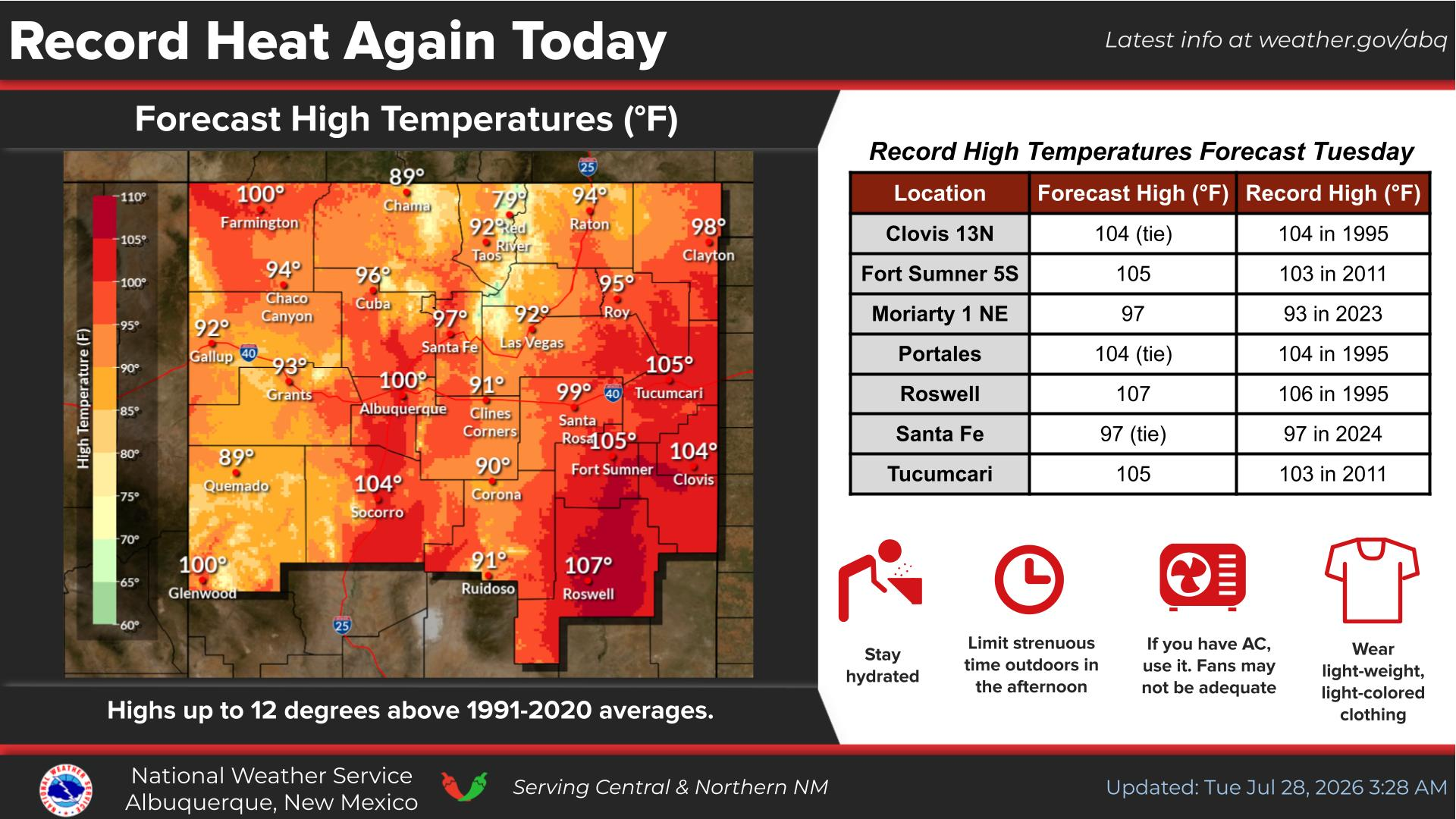
National Weather Service United States Department of Commerce
Click a location below for detailed forecast.

Last Map Update: Sat, May 10, 2025 at 2:38:10 pm MDT

Isolated-to-widely-scattered thunderstorms, dry thunderstorms, and virga showers will develop across the northern mountains, upper Rio Grande Valley, northwest plateau, Chuska Mountains, and west central plateau this afternoon and early evening. Localized, brief, and erratic wind gusts up to 50 mph are expected near some cells, as well as cloud-to-ground lightning.
Higher flows will continue in rivers, creeks, arroyos, and low water crossings across the northern mountains through the weekend, especially along the east slopes of the Sangre De Cristo Mountains. Recent heavy snow will continue to melt with any additional rainfall on existing snowpack today and tomrrow intensifying the melt and runoff.
Breezy-to-windy conditions and very low humidities will combine with high fire danger due to dry fuels to produce fire weather concerns over portions of south central and southwest New Mexico Tuesday, and probably again Wednesday.
Even less shower and thunderstorm activity is forecast for this afternoon and evening with slightly warmer temperatures once again. Shower and storm coverage will mostly be confined to the northern central and Chuska Mountains. Showers and storms will produce more in the way of gusty and erratic wind gusts of up to 45 mph rather than wetting rainfall.
Winds increase early this week peaking on Tuesday and Wednesday. Strong wind gusts of 40 to 55 mph will scatter and topple loose items like lawn furniture and garbage cans and result in difficult to hazardous crosswinds on the north to south oriented roads and highways. Dry conditions will also arrive, leading to an increased risk of fire spread for western and south-central areas.


Text Product Selector (Selected product opens in current window)


Submit Storm Report Icon

Submit Storm Report

Key Impacts Icon

Key Impacts

Observations Icon

Local Observations

Webcams Icon

Office Webcams

Satellite Icon

Satellite Imagery

Are You Prepared Icon

Are You Prepared?

Weekly Weather Briefing Icon

Weekly Weather Briefing

Area Forecast Discussion Icon

Area Forecast Discussion

Fire Weather Icon

Fire Weather

Aviation Weather Icon

Aviation Weather

Snow Probabilities Icon

Snow Probabilities

SKYWARN Icon

SKYWARN Spotters

On This Date in Weather History Icon

On This Date

Climate Graphs Icon

Climate Graphs

Drought Monitor Icon

Drought Monitor

Severe Weather Info and Climatology Icon

Severe Weather Climatology

Monsoon Awareness Icon

Monsoon Awareness

Winter Climatology Icon

Winter Climatology