National Weather Service United States Department of Commerce
News Headlines

Southwest wind gusts will peak up to 50 mph on Sunday, except for gusts around 60 mph in parts of the central mountain chain and eastern plains. The strong winds will produce areas of blowing dust at lower elevation, which may make driving hazardous.
Strong to damaging winds and low humidity values will create critical to locally extremely critical fire weather conditions on Sunday. The Red Flag Threat Index is a good way to quantify the severity of critical fire weather days.
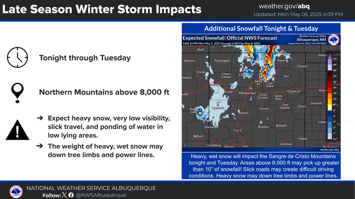
Light rain showers, thunderstorms, and mountain snow will continue today, then continue through tonight near the Colorado border. Stronger storms will produce more wind than rain with localized, brief, and erratic gusts up to 60 mph possible, as well as blowing dust.
One less spark, one less wildfire. Dry and windy conditions are expected through the weekend. Make sure to properly discard cigarettes, don't park on dry grass, and follow all fire restrictions.


Text Product Selector (Selected product opens in current window)


Submit Storm Report Icon

Submit Storm Report

Key Impacts Icon

Key Impacts

Observations Icon

Local Observations

Webcams Icon

Office Webcams

Satellite Icon

Satellite Imagery

Are You Prepared Icon

Are You Prepared?

Weekly Weather Briefing Icon

Weekly Weather Briefing

Area Forecast Discussion Icon

Area Forecast Discussion

Fire Weather Icon

Fire Weather

Aviation Weather Icon

Aviation Weather

Snow Probabilities Icon

Snow Probabilities

SKYWARN Icon

SKYWARN Spotters

On This Date in Weather History Icon

On This Date

Climate Graphs Icon

Climate Graphs

Drought Monitor Icon

Drought Monitor

Severe Weather Info and Climatology Icon

Severe Weather Climatology

Monsoon Awareness Icon

Monsoon Awareness

Winter Climatology Icon

Winter Climatology