National Weather Service United States Department of Commerce
Click a location below for detailed forecast.

Last Map Update: Fri, Nov 13, 2026 at 12:58:29 pm MST

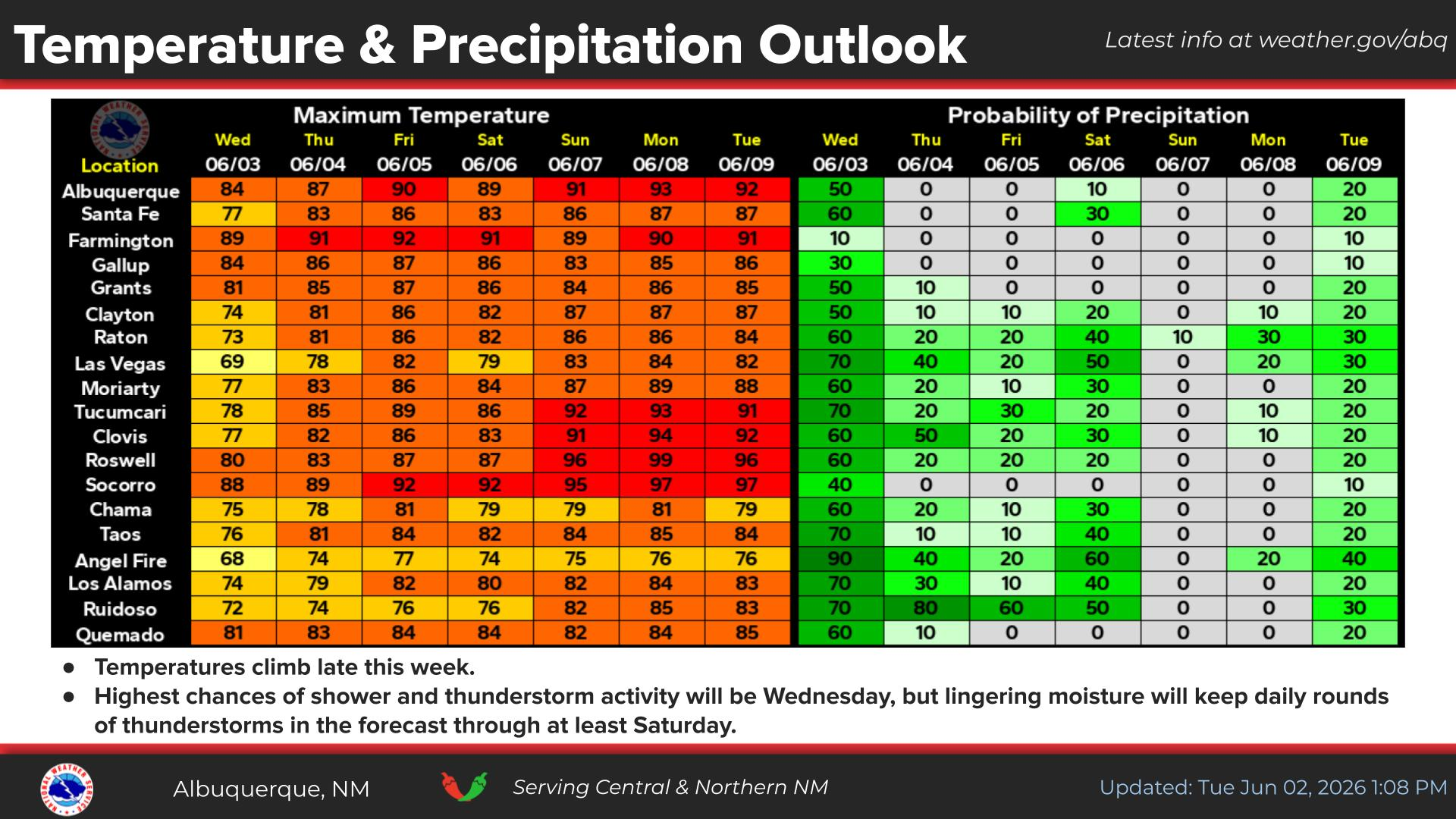
Showers with embedded thunderstorms enter southwestern NM this afternoon, spreading to more of eastern and northern NM tonight into Saturday morning. Some storms will produce gusty winds and brief moderate rainfall.
Valley rain and mountain snow spread over the northern mountains with rain and storms favoring the eastern plains through much of the day Saturday.
Snow above 9,000' will generally range 2-6 inches with locally higher amounts up to 8 inches atop the peaks. Slick winter travel will favor the U.S. 64 corridor through the Tusas Mts.
Cooler and wetter weather late today through the weekend. Calmer weather returns late Sunday through Monday before the next storm system looks to clip northwestern NM Tuesday.


Text Product Selector (Selected product opens in current window)


Submit Storm Report Icon

Submit Storm Report

Key Impacts Icon

Key Impacts

Observations Icon

Local Observations

Webcams Icon

Office Webcams

Satellite Icon

Satellite Imagery

Are You Prepared Icon

Are You Prepared?

Weekly Weather Briefing Icon

Weekly Weather Briefing

Area Forecast Discussion Icon

Area Forecast Discussion

Fire Weather Icon

Fire Weather

Aviation Weather Icon

Aviation Weather

Snow Probabilities Icon

Snow Probabilities

SKYWARN Icon

SKYWARN Spotters

On This Date in Weather History Icon

On This Date

Climate Graphs Icon

Climate Graphs

Drought Monitor Icon

Drought Monitor

Severe Weather Info and Climatology Icon

Severe Weather Climatology

Monsoon Awareness Icon

Monsoon Awareness

Winter Climatology Icon

Winter Climatology