Overview
|
Strong thunderstorms formed in the high-shear environment that was present as the remnants of once-Category-Five Hurricane Katrina passed through Pennsylvania. A few tornadoes formed as supercell thunderstorms moved through the Great Valley and Lower Susquehanna Valley just after midnight on the 31st. Sporadic wind damage occurred in other areas as well. |
Storm Relative Motion Image (from KLWX (Sterling, VA) radar) around the time tornado was on the ground in Adams County |
Maps
 |
 |
 |
 |
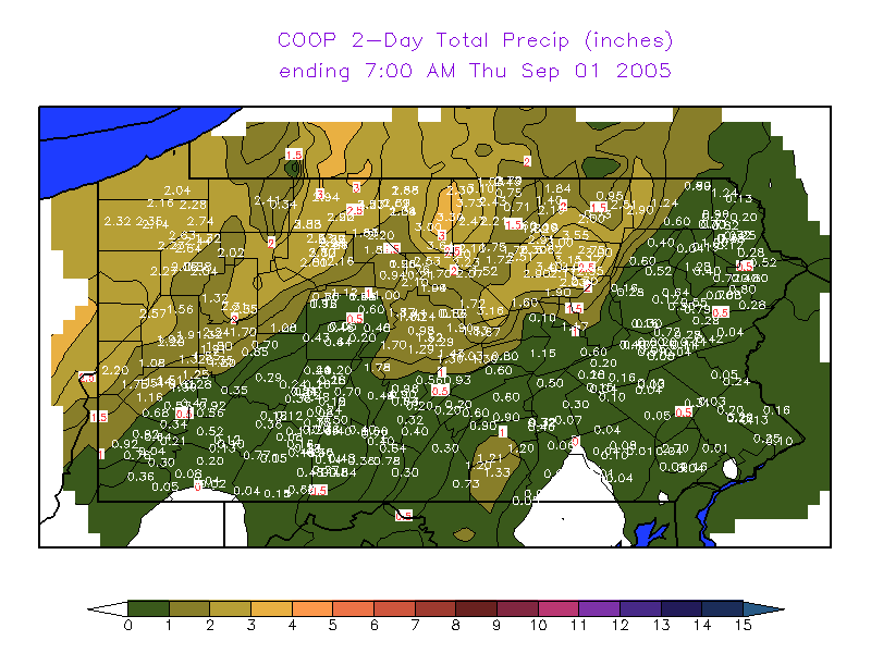
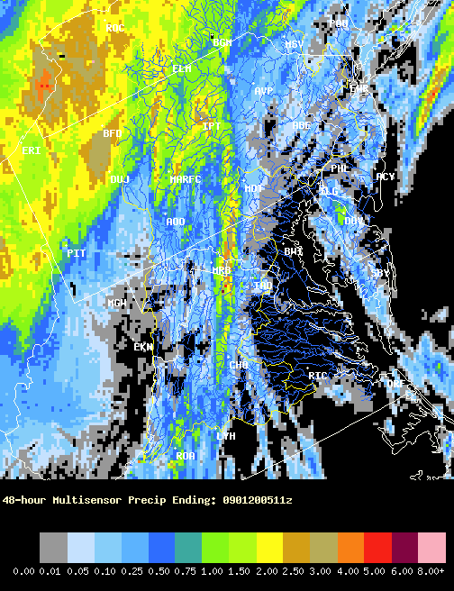
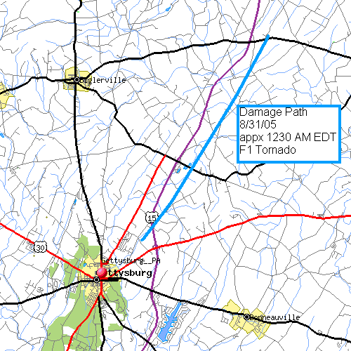
| 2-Day Total Cooperative Observer Precipitation reports | Rainfall Total (Multi-Sensor Precip Estimate from MARFC) for 48 hours | Damage Path | Damage Path |
 |
 |
 |
| Damage Path | Damage Path | Damage Path |
Storm Reports
NWUS51 KCTP 311255
LSRCTP
PRELIMINARY LOCAL STORM REPORT...CORRECTED
NATIONAL WEATHER SERVICE STATE COLLEGE PA
854 AM EDT WED AUG 31 2005
..TIME... ...EVENT... ...CITY LOCATION... ...LAT.LON...
..DATE... ....MAG.... ..COUNTY LOCATION..ST.. ...SOURCE....
..REMARKS..
1225 AM TSTM WND DMG FAIRFIELD 39.79N 77.37W
08/31/2005 ADAMS PA LAW ENFORCEMENT
HORSE TRAILER OVERTURNED.
1256 AM TSTM WND DMG 5 NE GETTYSBURG 39.88N 77.17W
08/31/2005 ADAMS PA LAW ENFORCEMENT
PSBL TORNADO. EXTENSIVE DAMAGE AROUND HUNTERSTOWN.
NUMEROUS TREES DOWN. 3 BARNS DESTROYED ON MILLAN ROAD.
ANOTHER BARN DESTROYED ON HUNTERSTOWN ROAD. SEVERAL POLES
SNAPPED OFF AND TREES TWISTED.
1256 AM TSTM WND DMG HEIDLERSBURG 39.93N 77.09W
08/31/2005 ADAMS PA LAW ENFORCEMENT
2 BARN ROOFS BLOWN OFF. NUMEROUS TREES DOWN.
0115 AM TSTM WND DMG DILLSBURG 40.11N 77.03W
08/31/2005 YORK PA EMERGENCY MNGR
TREES UPROOTED. ONE FELL ON A BARN. POSSIBLE TORNADO.
0120 AM TSTM WND DMG 2 S MECHANICSBURG 40.18N 77.01W
08/31/2005 CUMBERLAND PA EMERGENCY MNGR
NUMEROUS TREES DOWN...SOME ON CARS AND HOMES. 1200 PEOPLE
WITHOUT POWER. POSSIBLE TORNADO.
0127 AM TSTM WND DMG MECHANICSBURG 40.21N 77.01W
08/31/2005 CUMBERLAND PA LAW ENFORCEMENT
NUMEROUS TREES DOWN. TRAMPOLINE BLOWN ON CAR.
0130 AM TSTM WND DMG MECHANICSBURG 40.21N 77.01W
08/31/2005 CUMBERLAND PA LAW ENFORCEMENT
SEVERAL HOMES DAMAGED NEAR ASCO FARMS ALONG GREGOR COURT.
&&
$$
LAMBERT
NOUS41 KCTP 311430
PNSCTP
PAZ004>006-010>012-017>019-024>028-033>037-041-042-045-046-049>053-
056>059-063>066-010225-
PUBLIC INFORMATION STATEMENT
SPOTTER REPORTS
NATIONAL WEATHER SERVICE STATE COLLEGE PA
1025 AM EDT WED AUG 31 2005
THE FOLLOWING ARE UNOFFICIAL OBSERVATIONS TAKEN DURING THE PAST 24
HOURS FOR THE STORM THAT HAS BEEN AFFECTING OUR REGION.
APPRECIATION IS EXTENDED TO HIGHWAY DEPARTMENTS...COOPERATIVE
OBSERVERS...SKYWARN SPOTTERS AND MEDIA FOR THESE REPORTS. THIS
SUMMARY IS ALSO AVAILABLE ON OUR HOME PAGE AT WEATHER.GOV/CTP
**********************24 HOUR RAINFALL**********************
LOCATION 24 HOUR TIME/DATE COMMENTS
RAINFALL OF
(INCHES) MEASUREMENT
PENNSYLVANIA
...ADAMS COUNTY...
BIGLERVILLE 1.33 916 AM 8/31
...BLAIR COUNTY...
TYRONE 1.75 1012 AM 8/31
ALTOONA 1.10 913 AM 8/31
...CAMERON COUNTY...
EMPORIUM 1.35 914 AM 8/31
...CENTRE COUNTY...
CLARENCE 1.41 923 AM 8/31
...CLINTON COUNTY...
RENOVO 1.47 1017 AM 8/31
...CUMBERLAND COUNTY...
PINE GROVE FURNACE 1.21 915 AM 8/31
...ELK COUNTY...
RIDGWAY 2.51 1016 AM 8/31
...LYCOMING COUNTY...
LOYALSOCKVILLE 2.50 1002 AM 8/31
...MCKEAN COUNTY...
KANE 2.83 1013 AM 8/31
...NORTHUMBERLAND COUNTY...
SUNBURY 1.73 923 AM 8/31
...POTTER COUNTY...
SHINGLEHOUSE 2.46 957 AM 8/31
OSWAYO 1.84 912 AM 8/31
COUDERSPORT 1.38 1018 AM 8/31
...SNYDER COUNTY...
SELINSGROVE 1.05 1010 AM 8/31
...SULLIVAN COUNTY...
DUSHORE 2.50 1002 AM 8/31
...TIOGA COUNTY...
SABINSVILLE 2.51 1003 AM 8/31
WELLSBORO 1.66 1011 AM 8/31
COVINGTON 0.71 1007 AM 8/31
...UNION COUNTY...
LEWISBURG 1.31 924 AM 8/31
...WARREN COUNTY...
CHANDLERS VALLEY 2.85 1010 AM 8/31
WARREN 2.41 925 AM 8/31
********************STORM TOTAL RAINFALL********************
LOCATION STORM TOTAL TIME/DATE COMMENTS
RAINFALL OF
(INCHES) MEASUREMENT
PENNSYLVANIA
...CENTRE COUNTY...
STATE COLLEGE 1.50 909 AM 8/31
...TIOGA COUNTY...
SABINSVILLE 4.11 1003 AM 8/31
WELLSBORO 2.94 1011 AM 8/31
COVINGTON 2.21 1007 AM 8/31
...WARREN COUNTY...
CHANDLERS VALLEY 2.90 1010 AM 8/31
$$
PUBLIC INFORMATION STATEMENT
NATIONAL WEATHER SERVICE STATE COLLEGE PA
210 PM EDT WED AUG 31 2005
...PUBLIC INFORMATION STATEMENT...
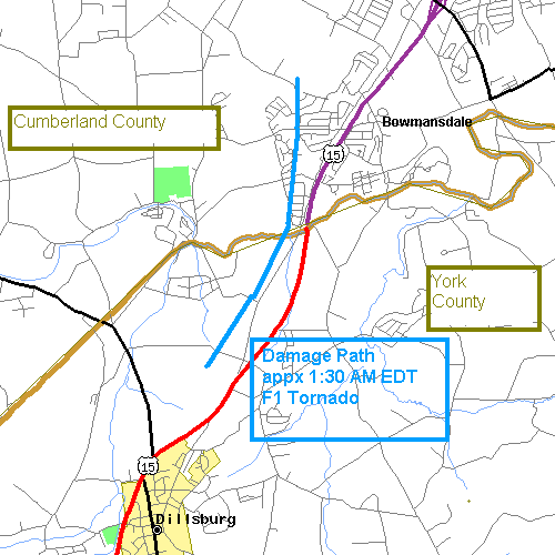
...LATE NIGHT TORNADO CONFIRMED IN YORK AND CUMBERLAND COUNTIES...
A STRONG F1 TORNADO WITH WINDS UP TO 110 MPH TOUCHED DOWN BETWEEN
DILLSBURG IN YORK COUNTY AND MECHANICSBURG IN CUMBERLAND COUNTY
PENNSYLVANIA AROUND 120 AM WEDNESDAY AUGUST 31. THE TORNADO CAUSED
EXTENSIVE TREE DAMAGE AND MOSTLY SUPERFICIAL DAMAGE TO A NUMBER OF
HOMES IN ITS PATH. TREES WERE UPROOTED AND SNAPPED WHILE THE HOMES
LOST SIDING AND SHINGLES.
SPECIFICALLY...THE TORNADO BEGAN ABOUT 117 AM NEAR THE
INTERSECTION OF OLD ROUTE 15 AND CREEK ROAD JUST SOUTH OF
ROSEGARDEN IN YORK COUNTY. THE TWISTER MOVED NORTH ACROSS YELLOW
BREECHES CREEK INTO CUMBERLAND COUNTY...THROUGH THE ASHCOMBE
FARMS SOUTH DEVELOPMENT...THEN ENDED ALONG STUMPSTOWN ROAD ABOUT A
HALF MILE WEST OF ROUTE 15 AT 122 AM. THE TORNADO PATH DAMAGE
WIDTH WAS ABOUT 100 YARDS WITH A LENGTH OF TWO AND A HALF MILES.
FORTUNATELY THERE WERE NO INJURIES OR DEATHS.
THE CUMBERLAND COUNTY EMERGENCY MANAGEMENT AND NATIONAL WEATHER
SERVICE TEAMED UP FOR A SURVEY OF THE DAMAGED AREA. WITNESSES TO
THE EVENT DESCRIBED THE STORM AS IF IT WERE A FREIGHT TRAIN MOVING
THROUGH THE NEIGHBORHOOD.
******************************************************************
PUBLIC INFORMATION STATEMENT
NATIONAL WEATHER SERVICE STATE COLLEGE PA
445 PM EDT WED AUG 31 2005
...PUBLIC INFORMATION STATEMENT...
...STRONG TORNADO CONFIRMED IN ADAMS COUNTY PENNSYLVANIA...
A STRONG F1 TORNADO WITH WINDS UP TO 100 MPH TOUCHED DOWN JUST
NORTHEAST OF GETTYSBURG AND TRACKED NORTHEASTWARD TO NEAR
HEILDERSBURG IN ADAMS COUNTY AROUND 1245 AM WEDNESDAY AUGUST 31.
THE TORNADO DESTROYED SEVERAL BARNS AND SHEDS AND REMOVED SOME
OUTBUILDING ROOFS. ADDITIONALLY THERE WAS TREE DAMAGE AND MOSTLY
SUPERFICIAL DAMAGE TO SEVERAL HOMES IN ITS PATH. TREES WERE
UPROOTED AND SNAPPED WHILE SOME HOMES LOST SIDING AND SHINGLES.
SPECIFICALLY...THE TORNADO BEGAN ABOUT 1238 AM NEAR THE
INTERSECTION OF HUNTERSTOWN AND SHEALER ROADS ABOUT A HALF MILE
WEST OF THE INTERSECTION OF ROUTES 15 AND 30. THE TORNADO TOUCHED
DOWN INTERMITTENTLY AT LOCATIONS ALONG A SEVEN MILE PATH JUST TO
THE EAST OF ROUTE 15 NEAR HUNTERSTOWN AND ENDING NEAR THE
INTERSECTION OF OXFORD ROAD AND ROUTE 234 NEAR HEILDERSBURG AT 1250
AM. THE TORNADO PATH DAMAGE WIDTH VARIED FROM 100 TO 300 YARDS AT
LOCATIONS ALONG THE PATH. FORTUNATELY THERE WERE NO INJURIES OR
DEATHS.
THE ADAMS COUNTY EMERGENCY MANAGEMENT AND NATIONAL WEATHER
SERVICE TEAMED UP FOR A SURVEY OF THE DAMAGED AREA TODAY. WITNESSES TO
THE EVENT DESCRIBED THE STORM AS HAVING THE CHARACTERISTIC NOISE
OF AN APPROACHING FREIGHT TRAIN WHEN IT PASSED THROUGH.
BUDD/GRUMM
******************************************************************
000
NOUS41 KCTP 012100
PNSCTP
PAZ036-056-057-059-063>066-020900-
PUBLIC INFORMATION STATEMENT
NATIONAL WEATHER SERVICE STATE COLLEGE PA
500 PM EDT THU SEP 1 2005
...PUBLIC INFORMATION STATEMENT...
...TWO ADDITIONAL TORNADOES CONFIRMED IN ADAMS COUNTY PENNSYLVANIA
EARLY WEDNESDAY MORNING...
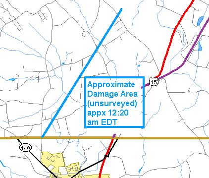
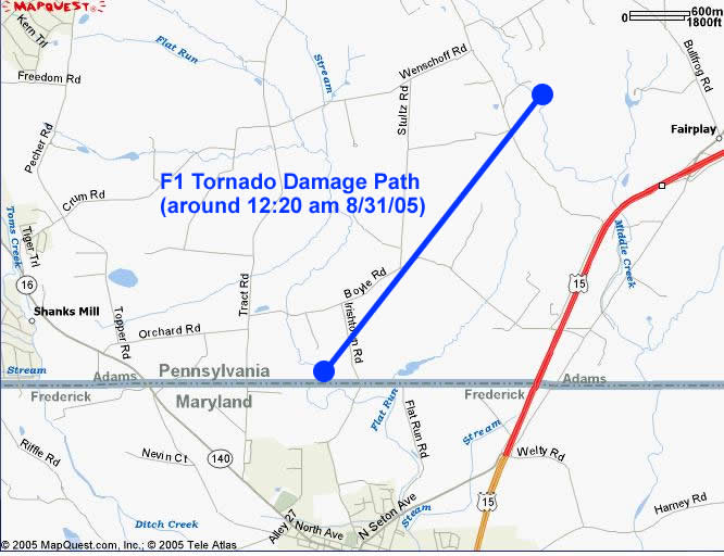
THE FIRST TORNADO WAS AN F1 WITH WINDS ESTIMATED BETWEEN 85 AND
95 MPH...AND WAS BETWEEN 100 AND 200 YARDS WIDE. THE TORNADO BEGAN
AT THE INTERSECTION OF ROUTE 16 AND TRACT ROAD AROUND 1220 AM NEAR
THE MARYLAND BORDER. THE TORNADO PATH LENGTH WAS 3 MILES AND IT
MOVED NORTHEAST...ENDING NEAR MIDDLE CREEK. SEVERAL TREES WERE
SNAPPED AND UPROOTED...WITH ROOF DAMAGE TO SOME BARNS. ALSO A
HEAVY HORSE TRAILER WAS OVERTURNED. A FEW HOMES ALSO HAD SOME
STRUCTURAL DAMAGE. FORTUNATELY THERE WERE NO INJURIES OR DEATHS.
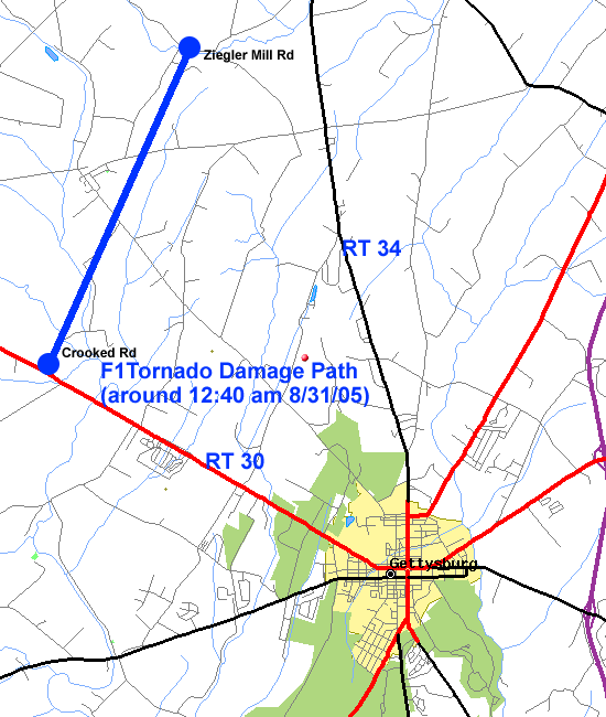
THE SECOND TORNADO WAS ALSO AN F1 WITH WINDS ESTIMATED BETWEEN 75
AND 85 MPH...AND WAS AROUND 50 YARDS WIDE. THE TORNADO BEGAN AT
THE INTERSECTION OF ROUTE 30 AND CROOKED CREEK ROAD IN FRANKLIN
TOWNSHIP AROUND 1240 AM. THIS TORNADO PATH LENGTH WAS INTERMITTENT
FOR 3 MILES AND IT MOVED NORTHEAST THROUGH MUMMASBURG...ENDING
NEAR CONEWAGO CREEK. MOST OF THE DAMAGE WAS TO CORN FIELDS...WITH
JUST A FEW TREES SNAPPED AND UPROOTED. THERE WERE ALSO NO INJURIES
OR DEATHS WITH THIS TORNADO.
$$
JV/BL/BB
******************************************************************
000
NOUS41 KCTP 012116
PNSCTP
PAZ012-037-041-042-045-046-049>053-020930-
PUBLIC INFORMATION STATEMENT
NATIONAL WEATHER SERVICE STATE COLLEGE PA
516 PM EDT THU SEP 1 2005
...PUBLIC INFORMATION STATEMENT...
...F1 TORNADO CONFIRMED IN LYCOMING COUNTY...
A SURVEY TEAM COMPOSED OF THE NATIONAL WEATHER SERVICE ALONG WITH
LYCOMING COUNTY AND LOCAL EMERGENCY MANAGEMENT PERSONNEL
CONFIRMED THAT AN F1 TORNADO TOUCHED DOWN BRIEFLY IN LYCOMING
COUNTY NEAR THE TOWN OF BARBOURS VERY EARLY WEDNESDAY MORNING.
THE TORNADO TOUCHED DOWN JUST SOUTHEAST OF THE TOWN OF BARBOURS...
ALONG ROUTE 87 ABOUT ONE HALF MILE SOUTH OF THE THE INTERSECTION
OF ROUTE 87 AND DUNWOODY ROAD. THE TORNADO TRAVELED NORTHEAST...AND
LIFTED ON DUNWOODY ROAD NEAR THE BARBOURS MUNICIPAL BUILDING.
THE PATH LENGTH OF THE TORNADO WAS ABOUT THREE QUARTERS OF A
MILE...WITH A PATH WIDTH OF ABOUT 100 YARDS. WIND SPEEDS WERE
ESTIMATED AROUND 90 MPH...PUTTING IT IN THE MIDDLE OF THE F1
RANGE. DAMAGE WAS CONFINED MAINLY TO TREES...AS THE TORNADO
TRAVELED THROUGH A HEAVILY WOODED AREA. THERE WERE NO INJURIES OR
DEATHS ASSOCIATED WITH THE TORNADO.
THE TORNADO DAMAGE WAS EMBEDDED IN A LARGER SWATH OF SPORADIC
STRAIGHT LINE WIND DAMAGE...THAT EXTENDED ABOUT 2 MILES FROM THE
NORTHERN EDGE OF THE TIADAGHTON STATE FOREST...TO THE EDGE OF THE
STATE GAME LANDS NORTHEAST OF THE TOWN OF BARBOURS.
FOR REFERENCE...THE FUJITA TORNADO CLASSIFICATION SYSTEM
CLASSIFIES TORNADOES INTO THE FOLLOWING CATEGORIES:
F0...WIND SPEEDS 40 TO 72 MPH.
F1...WIND SPEEDS 73 TO 112 MPH.
F2...WIND SPEEDS 113 TO 157 MPH.
F3...WIND SPEEDS 158 TO 206 MPH.
F4...WIND SPEEDS 207 TO 260 MPH.
F5...WIND SPEEDS 261 TO 318 MPH.
$$
JUNG
 |
Media use of NWS Web News Stories is encouraged! Please acknowledge the NWS as the source of any news information accessed from this site. |
|


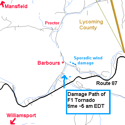 Damage path of F1 tornado that occurred in Northern Lycoming County later that night
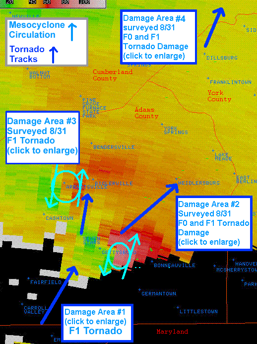
 Send Us a Report