Overview
|
July 9th turned out to be a very busy day (as was June 9th) - with early reports totalling over 30 severe events (and many sub-severe hail reports) occurring from early afternoon through early evening. The Storms fired up on the ridges of west-central PA, as the heating of the day and the cold pool aloft from an upper low combined to create great instability. See the KLWX (Washington DC) 18z sounding for the details on the environment just to our south. We must have been even more unstable, since hardly any convection fired south of the Mason-Dixon Line that day. The weak wind profile (also seen on the LWX sounding) contributed to the slow movement of many of the cells, and kept wind damage from being a primary threat. The main threat was hail - and large hail at that (0.88 to 1.00 inch hail was common). |
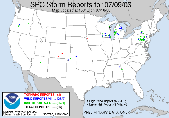 SPC Storm Reports 7/9/2006 |
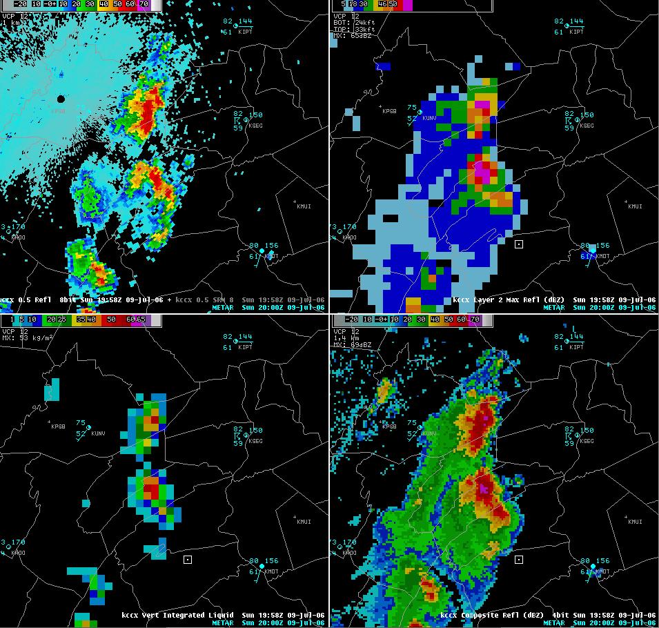
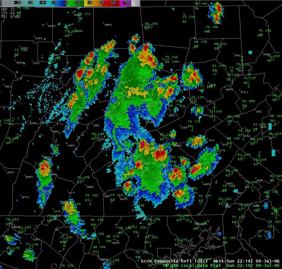
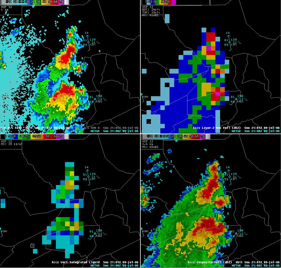
Radar & Skew T
 |
 |
 |
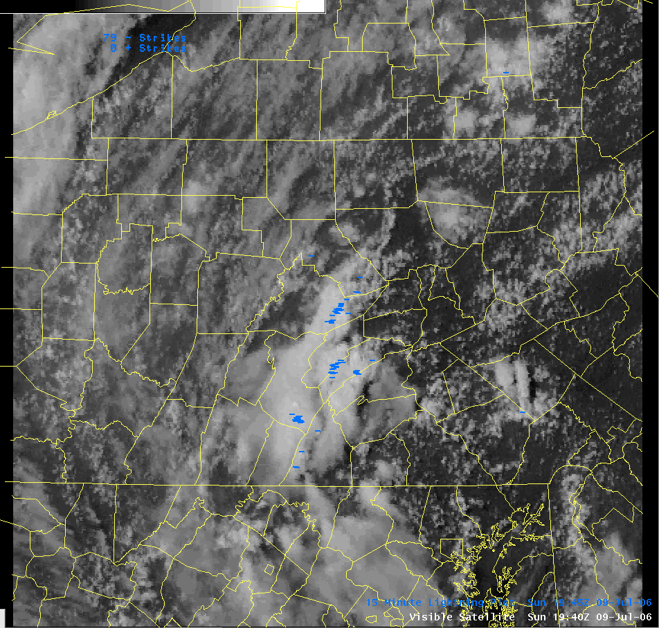 |
| Storm over Juniata County dropping large inch hail | Multiple Severe Thunderstorms near Harrisburg, Lebanon, and Lancaster | Storm over Williamsport dropping large hail | Visible satellite image and lightning plot of storms over Centre, Huntingdon, Mifflin and Juniata counties around 3:45 pm. |
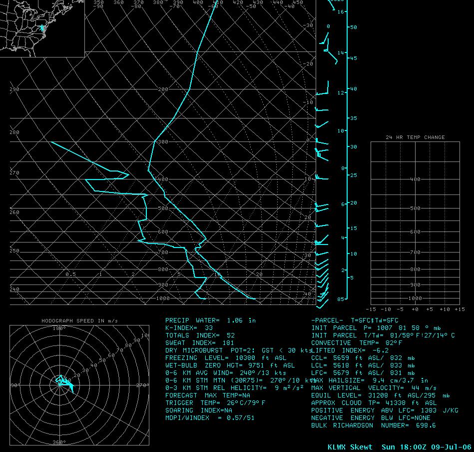 |
| Sterling, VA Sounding from 18z 7/9/06 |
Storm Reports
NWUS51 KCTP 100553
LSRCTP
PRELIMINARY LOCAL STORM REPORT...CORRECTED
NATIONAL WEATHER SERVICE STATE COLLEGE PA
152 AM EDT MON JUL 10 2006
..TIME... ...EVENT... ...CITY LOCATION... ...LAT.LON...
..DATE... ....MAG.... ..COUNTY LOCATION..ST.. ...SOURCE....
..REMARKS..
0150 PM HAIL MOUNT HOLLY SPRINGS 40.11N 77.18W
07/09/2006 E0.75 INCH CUMBERLAND PA PUBLIC
HAIL LASTED 20 MINUTES
0225 PM TSTM WND DMG ALEXANDRIA 40.56N 78.10W
07/09/2006 HUNTINGDON PA LAW ENFORCEMENT
WIRES DOWN
0228 PM HAIL SALTILLO 40.21N 78.01W
07/09/2006 E0.75 INCH HUNTINGDON PA PUBLIC
0416 PM HAIL MIFFLINTOWN 40.57N 77.40W
07/09/2006 E0.88 INCH JUNIATA PA PUBLIC
0430 PM HAIL MCCLURE 40.71N 77.31W
07/09/2006 E0.88 INCH SNYDER PA TRAINED SPOTTER
0505 PM HAIL COGAN STATION 41.31N 77.03W
07/09/2006 E0.75 INCH LYCOMING PA TRAINED SPOTTER
0524 PM HAIL CARLISLE 40.20N 77.20W
07/09/2006 E0.88 INCH CUMBERLAND PA PUBLIC
0529 PM HAIL WILLIAMSPORT 41.24N 77.02W
07/09/2006 E0.75 INCH LYCOMING PA PUBLIC
0540 PM HAIL 2 W HOGESTOWN 40.23N 77.08W
07/09/2006 E1.00 INCH CUMBERLAND PA NWS EMPLOYEE
0541 PM HAIL EPHRATA 40.18N 76.18W
07/09/2006 E0.50 INCH LANCASTER PA EMERGENCY MNGR
0542 PM HAIL ENOLA 40.29N 76.94W
07/09/2006 E1.00 INCH CUMBERLAND PA PUBLIC
0544 PM HAIL LEWISBURG 40.96N 76.89W
07/09/2006 E0.25 INCH UNION PA EMERGENCY MNGR
0545 PM HAIL WATSONTOWN 41.08N 76.86W
07/09/2006 E0.50 INCH NORTHUMBERLAND PA TRAINED SPOTTER
0546 PM HAIL SNOW SHOE 41.03N 77.95W
07/09/2006 E0.50 INCH CENTRE PA TRAINED SPOTTER
0547 PM HAIL MARYSVILLE 40.34N 76.93W
07/09/2006 E1.00 INCH PERRY PA PUBLIC
0607 PM TSTM WND DMG ADAMSTOWN 40.24N 76.06W
07/09/2006 LANCASTER PA TRAINED SPOTTER
SOME TREES DOWN. WIND GUSTS OF 49 MPH
0617 PM HAIL 1 SE PENN NATIONAL RACE 40.39N 76.66W
07/09/2006 E1.00 INCH DAUPHIN PA PUBLIC
ONE INCH HAIL REPORTED IN GRANTVILLE.
0621 PM HAIL MANHEIM 40.16N 76.40W
07/09/2006 E0.88 INCH LANCASTER PA EMERGENCY MNGR
0622 PM HAIL EPHRATA 40.18N 76.18W
07/09/2006 E1.00 INCH LANCASTER PA PUBLIC
0623 PM HAIL HALIFAX 40.47N 76.93W
07/09/2006 E1.00 INCH DAUPHIN PA PUBLIC
0625 PM HAIL ADAMSTOWN 40.24N 76.06W
07/09/2006 E0.88 INCH LANCASTER PA TRAINED SPOTTER
0625 PM HAIL MILLERSBURG 40.54N 76.96W
07/09/2006 E0.88 INCH DAUPHIN PA EMERGENCY MNGR
0626 PM HAIL LEBANON 40.34N 76.42W
07/09/2006 E0.75 INCH LEBANON PA PUBLIC
0628 PM HAIL 1 SE PENN NATIONAL RACE 40.39N 76.66W
07/09/2006 E0.88 INCH DAUPHIN PA TRAINED SPOTTER
NICKEL SIZE HAIL REPORTED IN GRANTVILLE.
0629 PM HAIL 3 SSE COLUMBIA 39.99N 76.47W
07/09/2006 E0.75 INCH LANCASTER PA PUBLIC
THREE QUARTER INCH HAIL REPORTED IN WASHINGTON BORO.
0630 PM HAIL ENOLA 40.29N 76.94W
07/09/2006 E0.88 INCH CUMBERLAND PA PUBLIC
0630 PM HAIL 2 NNE DENVER 40.26N 76.12W
07/09/2006 E0.88 INCH LANCASTER PA PUBLIC
NICKEL SIZE HAIL REPORTED IN REINHOLDS
0631 PM HAIL 2 ESE EPHRATA 40.17N 76.15W
07/09/2006 E0.88 INCH LANCASTER PA PUBLIC
NICKEL SIZE HAIL REPORTED IN STEVENS.
0640 PM HAIL DENVER 40.23N 76.14W
07/09/2006 E0.88 INCH LANCASTER PA PUBLIC
0648 PM HAIL DENVER 40.23N 76.14W
07/09/2006 E1.25 INCH LANCASTER PA PUBLIC
0648 PM HAIL 1 WSW KLEINFELTERSVILLE 40.30N 76.29W
07/09/2006 E0.88 INCH LEBANON PA PUBLIC
NICKEL SIZE HAIL REPORTED IN SCHAEFFERSTOWN.
0650 PM HAIL FREDERICKSBURG 40.46N 76.43W
07/09/2006 E1.00 INCH LEBANON PA PUBLIC
0716 PM HAIL 1 SW MINERSVILLE 40.68N 76.27W
07/09/2006 E0.88 INCH SCHUYLKILL PA PUBLIC
NICKEL SIZE HAIL REPORTED IN LLEWELLYN.
0718 PM HAIL MYERSTOWN 40.37N 76.31W
07/09/2006 E0.75 INCH LEBANON PA PUBLIC
0720 PM HAIL NEWMANSTOWN 40.35N 76.21W
07/09/2006 E0.75 INCH LEBANON PA PUBLIC
0729 PM HAIL 1 NW SUMMIT STATION 40.59N 76.23W
07/09/2006 E0.88 INCH SCHUYLKILL PA PUBLIC
NICKEL SIZE HAIL REPORTED IN FRIEDENSBURG.
1205 AM HAIL MOUNT JOY 40.11N 76.51W
07/10/2006 M0.50 INCH LANCASTER PA PUBLIC
&&
$$
CRUZ/DNM
 |
Media use of NWS Web News Stories is encouraged! Please acknowledge the NWS as the source of any news information accessed from this site. |
|


 Send Us a Report