Overview
Another round of severe weather hit Central Pennsylvania during the afternoon of August 30th, 2007 producing small hail and damaging winds across the area. Numerous trees and wires were brought down by thunderstorm winds across Clearfield and Huntingdon counties. In addition some storms produced nickel and pea-sized hail.
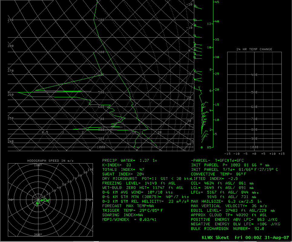
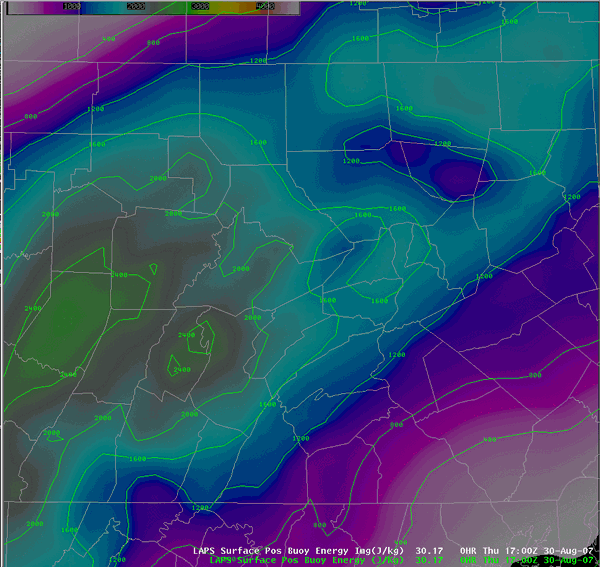
The storms were caused by a cold front that was moving across the region lifting warm, unstable air ahead of it. A maximized area of instability just ahead of the front in Central Pennsylvania fueled the storms. Some of these storms produced outflow boundaries that interacted with the northeast-to-southwest oriented cold front causing storms to redevelop from northeast to southwest as the front sliced through the area. Numerous reports of funnel clouds were received that evening in real time as the event was on-going. See the maps/pictures below for a quick summary of the storms Wed Evening.
 |
 |
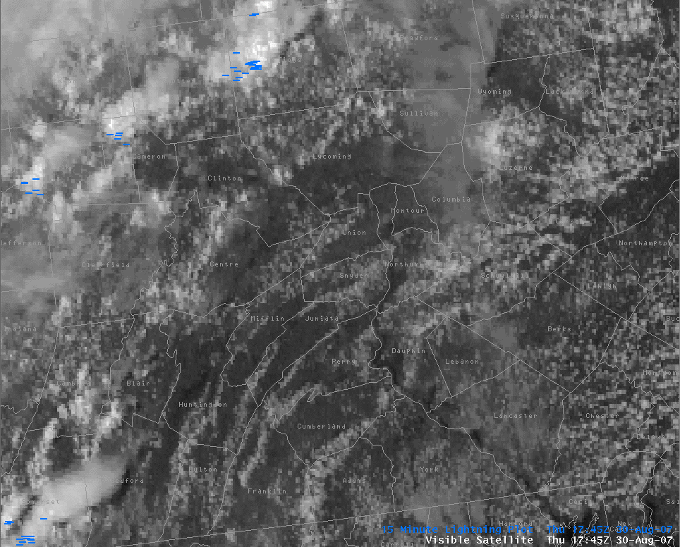 |
| Surface analysis at 2:00 pm | CAPE surface analysis loop showing high values just ahead of the front | Visible satellite loop and lightning plot during the event |
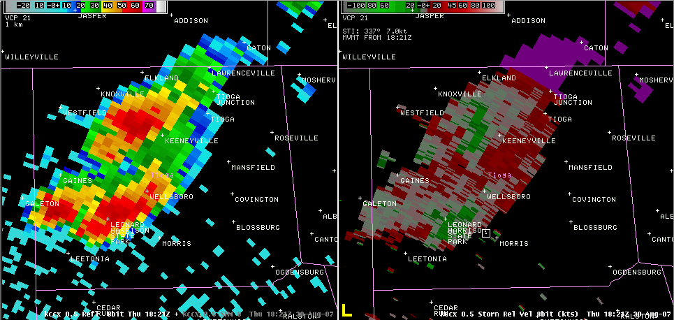
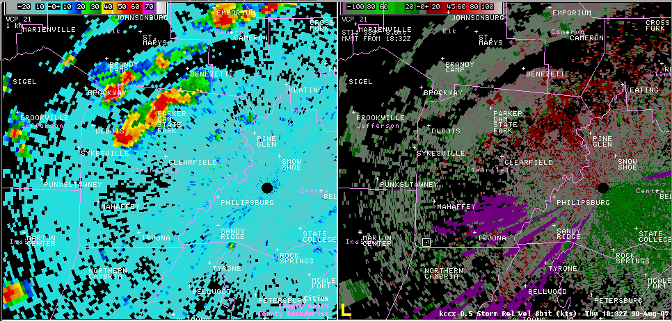
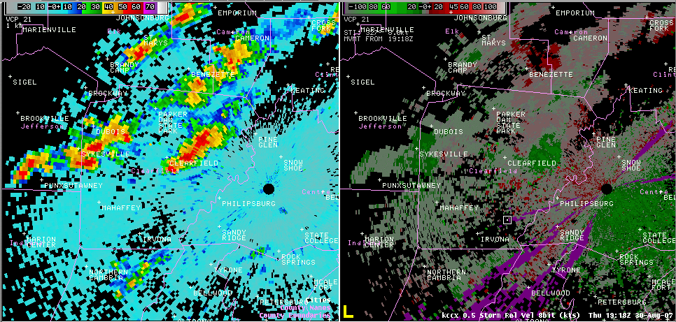
Radar
 |
 |
 |
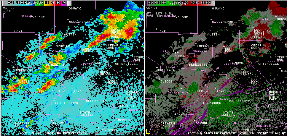 |
| KCCX reflectivity and storm relative velocity 2:12 pm over Tioga county | KCCX reflectivity and storm relative velocity 2:32 pm over Clearfield county | KCCX reflectivity and storm relative velocity 3:18 pm over Clearfield county | KCCX radar and velocity loop showing thunderstorm outflow boundaries interacting with surface front |
Storm Reports
000
NWUS51 KCTP 311437
LSRCTP

PRELIMINARY LOCAL STORM REPORT...SUMMARY
NATIONAL WEATHER SERVICE STATE COLLEGE PA
1037 AM EDT FRI AUG 31 2007

..TIME...   ...EVENT...      ...CITY LOCATION...     ...LAT.LON...
..DATE...   ....MAG....      ..COUNTY LOCATION..ST.. ...SOURCE....
            ..REMARKS..

0221 PM     TSTM WND DMG     2 N KEENEYVILLE         41.89N 77.26W
08/30/2007                   TIOGA              PA   EMERGENCY MNGR

            TREE DOWN ACROSS CUMMINGS CREEK ROAD

0230 PM     HAIL             4 NE DUBOIS             41.16N 78.70W
08/30/2007  E0.88 INCH       CLEARFIELD         PA   BROADCAST MEDIA

            NICKEL SIZE HAIL REPORTED IN SANDY TOWNSHIP NEAR TREASURE
            LAKE.

0245 PM     TSTM WND DMG     4 NE DUBOIS             41.16N 78.70W
08/30/2007                   CLEARFIELD         PA   BROADCAST MEDIA

            NUMEROUS TREES AND POWERLINES DOWN NEAR TREASURE LAKE IN
            SANDY TOWNSHIP.

0250 PM     HAIL             1 SE EMPORIUM           41.50N 78.22W
08/30/2007  E0.25 INCH       CAMERON            PA   TRAINED SPOTTER

            PEA SIZE HAIL ALONG ROUTE 120.

0315 PM     HAIL             5 E CLEARFIELD          41.02N 78.34W
08/30/2007  E0.25 INCH       CLEARFIELD         PA   NWS EMPLOYEE

            PEA SIZE HAIL ALONG INTERSTATE 80 NEAR CLEARFIELD.

0320 PM     TSTM WND DMG     3 NE DUBOIS             41.15N 78.71W
08/30/2007                   CLEARFIELD         PA   EMERGENCY MNGR

            NUMEROUS TREES DOWN AND FIVE HOMES DAMAGED IN SABULA.

0440 PM     HAIL             4 W STATE COLLEGE       40.79N 77.93W
08/30/2007  E0.25 INCH       CENTRE             PA   NWS EMPLOYEE

            PEA SIZE HAIL IN STORMSTOWN.

0505 PM     FLASH FLOOD      2 S BLOSSBURG           41.65N 77.07W
08/30/2007                   TIOGA              PA   EMERGENCY MNGR

            WATER COVERING THE NORTHBOUND LANE OF ROUTE 15 NEAR
            BLOSSBURG.

0536 PM     TSTM WND DMG     WARRIORS MARK           40.70N 78.11W
08/30/2007                   HUNTINGDON         PA   LAW ENFORCEMENT

            TREES DOWN.

0600 PM     HAIL             WILLIAMSPORT            41.24N 77.02W
08/30/2007  E0.25 INCH       LYCOMING           PA   TRAINED SPOTTER

            PEA SIZE HAIL ALONG WITH 35-40 MPH GUSTS. ESTIMATED ONE
            INCH OF RAIN IN ONE HOUR IN WILLIAMSPORT.
 |
Media use of NWS Web News Stories is encouraged! Please acknowledge the NWS as the source of any news information accessed from this site. |
|


 Send Us a Report