Overview
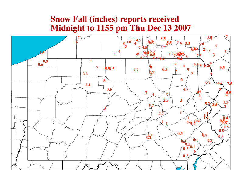
On Thursday, December 13th, the region experienced a widespread winter storm. The storm only produced precipitation for 8 or 9 hours, but packed a whollop. See the reports below for the snow (and sleet) accumulations. Snow was deepest over the North, with Sleet the predominant precipitation type in the central third of the state. Freezing rain fell across the southern third to half of the state, accumulating up to a third of an inch on trees, power lines, and untreated surfaces, but turned to plain rain later in the storm. The heavy sleet and ice caused a few power outages.
 |
| Snow (and Sleet) from Dec 13th |
Storm Reports
NOUS41 KCTP 140249
PNSCTP
PAZ004>006-010>012-017>019-024>028-033>037-041-042-045-046-049>053-
056>059-063>066-141447-
PUBLIC INFORMATION STATEMENT
SPOTTER REPORTS
NATIONAL WEATHER SERVICE STATE COLLEGE PA
947 PM EST THU DEC 13 2007
THE FOLLOWING ARE UNOFFICIAL OBSERVATIONS TAKEN DURING THE PAST 24 HOURS
FOR THE STORM THAT HAS BEEN AFFECTING OUR REGION. APPRECIATION IS EXTENDED
TO HIGHWAY DEPARTMENTS...COOPERATIVE OBSERVERS...SKYWARN SPOTTERS
AND MEDIA FOR THESE REPORTS. THIS SUMMARY IS ALSO AVAILABLE ON OUR
HOME PAGE AT WEATHER.GOV/CTP
********************STORM TOTAL SNOWFALL********************
LOCATION STORM TOTAL TIME/DATE COMMENTS
SNOWFALL OF
(INCHES) MEASUREMENT
PENNSYLVANIA
...CAMERON COUNTY...
EMPORIUM 8.0 130 PM 12/13
SINNEMAHONING 3.1 255 PM 12/13
...CENTRE COUNTY...
PHILIPSBURG 3.0 620 PM 12/13
...COLUMBIA COUNTY...
BENTON 5.0 600 PM 12/13
ORANGEVILLE 2.5 200 PM 12/13
...CUMBERLAND COUNTY...
CAMP HILL 0.1 500 PM 12/13 SLEET
...DAUPHIN COUNTY...
HARRISBURG 0.5 630 PM 12/13 SLEET
...ELK COUNTY...
RIDGWAY 1.4 257 PM 12/13
...LYCOMING COUNTY...
MUNCY 4.0 430 PM 12/13
WILLIAMSPORT 3.0 300 PM 12/13 TURNING TO SLEET
...MCKEAN COUNTY...
SMETHPORT 7.0 100 PM 12/13
BRADFORD 4.0 200 PM 12/13
KANE 2.3 100 PM 12/13 SNOW AND SLEET
...NORTHUMBERLAND COUNTY...
SHAMOKIN 2.2 345 PM 12/13
MONTANDON 1.5 530 PM 12/13
...POTTER COUNTY...
COUDERSPORT 6.5 110 PM 12/13
ROULETTE 5.5 1230 PM 12/13
...SCHUYLKILL COUNTY...
MUIR 1.0 315 PM 12/13 SLEET MELTING
TAMAQUA 1.0 316 PM 12/13 SLEET
AUBURN 0.9 545 PM 12/13 SLEET
...TIOGA COUNTY...
WELLSBORO 7.2 200 PM 12/13 TURNING TO SLEET
$$
 |
Media use of NWS Web News Stories is encouraged! Please acknowledge the NWS as the source of any news information accessed from this site. |
|


 Send Us a Report