Overview
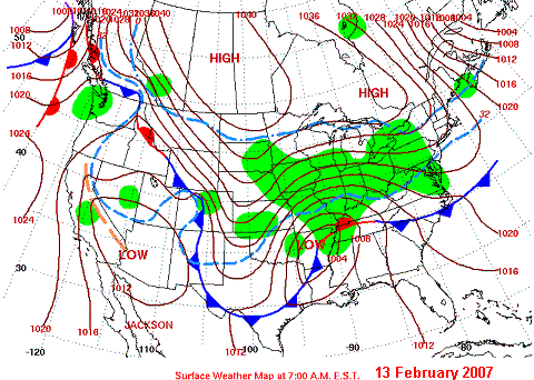
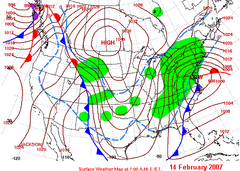
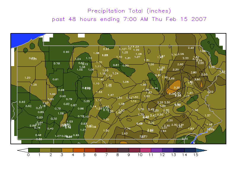
A complex and wide-reaching winter storm moved from the Mid-Mississippi Valley into the Tennessee Valley on Tuesday the 13th of February, and into the Mid Atlantic and New England on the 14th and 15th of February. This strong storm produced widespread snowfall across the Mid Atlantic and New England. The heaviest hit areas were the Adirondack Mountains in New York and Northern Vermont where over 2 feet of snow fell! Across Pennsylvania totals ranged from a few inches in the far Southeast to around 20 inches in the Northeast.Maps & Figures
 |
 |
 |
 |
| US Surface Chart, Tuesday Morning (2/13/2007), 1200UTC (7am EST) | US Surface Chart, Wednesday Morning (2/14/2007), 1200UTC (7am EST) | COOP Rainfall Map Showing 2 Day Total Precipitation 7:00 am Feb 13 to 7:00 am Feb 15 |
COOP Snowfall Map Showing 2 Day Total Snowfall 7:00 am Feb 13 to 7:00 am Feb 15 |
Storm Reports
000
NOUS41 KCTP 151658
PNSCTP
PAZ004>005-010>012-017>019-024>028-033>034-037-041>042-045>046-
049>053-056>059-063-065>066-160300-

PUBLIC INFORMATION STATEMENT
SPOTTER REPORTS
NATIONAL WEATHER SERVICE STATE COLLEGE PA
1158 AM EST THU FEB 15 2007

THE FOLLOWING ARE COOP STORM TOTAL SNOWFALL ACCUMULATIONS IN INCHES
FOR THE VALENTINES DAY STORM OF 2007 FROM THE NATIONAL WEATHER
SERVICE IN STATE COLLEGE PA. THANKS TO COOPERATIVE OBSERVERS AND THE
PUBLIC FOR YOUR REPORTS. THIS SUMMARY CAN ALSO BE FOUND ON OUR HOME
PAGE AT HTTP://WWW.NWS.NOAA.GOV/CTP

********************STORM TOTAL SNOWFALL********************

LOCATION          STORM TOTAL    TIME/DATE    COMMENTS
                     SNOWFALL       OF
                     (INCHES)   MEASUREMENT


PENNSYLVANIA

...ADAMS COUNTY...
   BIGLERVILLE            6.0   700 AM  2/15   COOP REPORT

...BEDFORD COUNTY...
   BUFFALO MILLS          5.1   700 AM  2/15   COOP REPORT
   EVERETT                6.3   700 AM  2/15   COOP REPORT
   WOLFSBURG              4.8   700 AM  2/15   COOP REPORT

...BLAIR COUNTY...
   ALTOONA                7.0   700 AM  2/15   COOP REPORT
   WILLIAMSBURG           7.3   700 AM  2/15   COOP REPORT

...CAMBRIA COUNTY...
   EBENSBURG             10.5   500 PM  2/14   PUBLIC REPORT
   JOHNSTOWN             11.0  1200 PM  2/14   PUBLIC REPORT
   PRINCE GALLITZIN      14.6   700 AM  2/15   COOP REPORT

...CAMERON COUNTY...
   SINNEMAHONING         10.5   700 AM  2/15   COOP REPORT
   EMPORIUM              10.0   500 PM  2/14   PUBLIC REPORT
   STEVENSON DAM          8.5   700 AM  2/15   COOP REPORT

...CENTRE COUNTY...
   PHILIPSBURG 2S        10.7   700 AM  2/15   COOP REPORT
   CLARENCE               9.0   700 AM  2/15   COOP REPORT
   STATE COLLEGE         10.4   700 AM  2/15   COOP REPORT

...CLEARFIELD COUNTY...
   GRAMPIAN               9.9   700 AM  2/15   COOP REPORT

...CLINTON COUNTY...
   LOCK HAVEN            12.5   700 AM  2/15   COOP REPORT
   RENOVO                 9.5   700 AM  2/15   COOP REPORT

...COLUMBIA COUNTY...
   BENTON                10.6   700 AM  2/15   COOP REPORT

...CUMBERLAND COUNTY...
   PINE GROVE FURNACE     6.0   700 AM  2/15   COOP REPORT

...DAUPHIN COUNTY...
   DEHART DAM             6.5   700 AM  2/15   COOP REPORT
   HARRISBURG             6.5   700 AM  2/15   COOP REPORT
   HERSHEY                7.0   700 AM  2/15   COOP REPORT

...ELK COUNTY...
   RIDGWAY                9.1   700 AM  2/15   COOP REPORT
   WILCOX                 9.0   700 AM  2/15   COOP REPORT

...FRANKLIN COUNTY...
   GREENCASTLE            5.3   800 AM  2/15   PUBLIC REPORT
   SOUTH MOUNTAIN         6.0   700 AM  2/15   COOP REPORT
   UP. STRASBURG          7.0   700 AM  2/15   COOP REPORT

...HUNTINGDON COUNTY...
   HUNTINGDON             7.0   700 AM  2/15   COOP REPORT
   RAYSTOWN LAKE          8.0   700 AM  2/15   COOP REPORT

...LANCASTER COUNTY...
   GLEN MOORE             5.8   700 AM  2/15   COOP REPORT
   HOLTWOOD               5.5   700 AM  2/15   COOP REPORT
   LANCASTER              8.0   700 AM  2/15   COOP REPORT
   NEW HOLLAND            7.5   700 AM  2/15   COOP REPORT
   SAFE HARBOR            5.0   700 AM  2/15   COOP REPORT

...LYCOMING COUNTY...
   ELMSPORT               8.5  1255 PM  2/14   PUBLIC REPORT
   MUNCY                 11.5  1000 AM  2/15   PUBLIC REPORT
   WILLIAMSPORT           8.5   500 PM  2/14   PUBLIC REPORT

...MCKEAN COUNTY...
   CLERMONT              14.0   700 AM  2/15   COOP REPORT
   KANE                  11.9   700 AM  2/15   COOP REPORT
   PORT ALLEGHENY        11.0   700 AM  2/15   COOP REPORT

...MIFFLIN COUNTY...
   LEWISTOWN              7.0   700 AM  2/15   COOP REPORT

...NORTHUMBERLAND COUNTY...
   SHAMOKIN              11.0   400 PM  2/14   PUBLIC REPORT
   SUNBURY               12.5   700 AM  2/15   COOP REPORT
   WATSONTOWN             9.0   500 PM  2/14   PUBLIC REPORT

...POTTER COUNTY...
   COUDERSPORT           14.0   700 AM  2/15   COOP REPORT
   OSWAYO                14.0   700 AM  2/15   COOP REPORT

...SCHUYLKILL COUNTY...
   MAHANOY CITY          10.5   700 AM  2/15   COOP REPORT
   PINE GROVE             6.0   700 AM  2/15   COOP REPORT
   SHENANDOAH HEIGHTS     9.5   500 PM  2/15   PUBLIC REPORT
   ZION GROVE            15.0   500 PM  2/14   PUBLIC REPORT

...SNYDER COUNTY...
   SELINSGROVE            5.8   700 AM  2/15   COOP REPORT

...SOMERSET COUNTY...
   CONFLUENCE             7.0   700 AM  2/15   COOP REPORT
   GLENCOE                6.1   700 AM  2/15   COOP REPORT
   LAUREL SUMMIT         15.6   700 AM  2/15   COOP REPORT
   MOUNT DAVIS           12.5   700 AM  2/15   COOP REPORT
   SOMERSET               7.9   700 AM  2/15   COOP REPORT

...SULLIVAN COUNTY...
   LAPORTE               14.0   700 AM  2/15   COOP REPORT

...TIOGA COUNTY...
   COWANESQUE DAM        11.5   700 AM  2/15   COOP REPORT
   COVINGTON             11.5   700 AM  2/15   COOP REPORT
   WELLSBORO             14.0   530 PM  2/14   PUBLIC REPORT
   SABINSVILLE           13.5   700 AM  2/15   COOP REPORT

...UNION COUNTY...
   LEWISBURG              7.5   530 PM  2/14   PUBLIC REPORT

...WARREN COUNTY...
   CHANDLERS VALLEY      12.0   700 AM  2/15   COOP REPORT
   WARREN                16.5   500 PM  2/14   PUBLIC REPORT

...YORK COUNTY...
   HANOVER                5.6   700 AM  2/15   COOP REPORT
   YORK HAVEN             7.5   700 AM  2/15   COOP REPORT

$$

CONNELLY
 |
Media use of NWS Web News Stories is encouraged! Please acknowledge the NWS as the source of any news information accessed from this site. |
|


 Send Us a Report