Overview
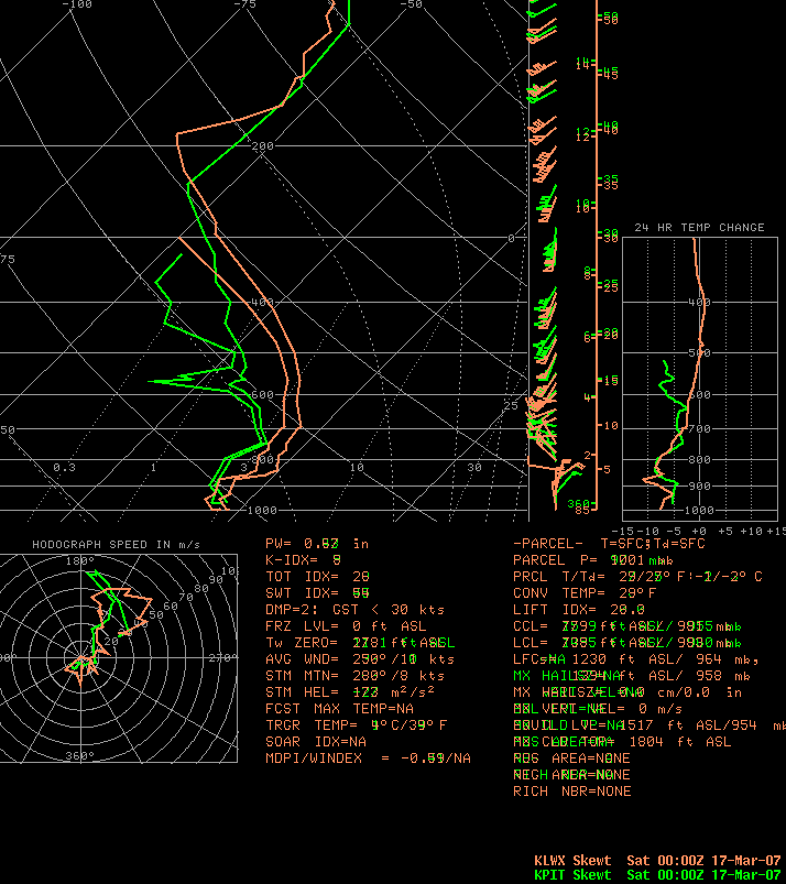
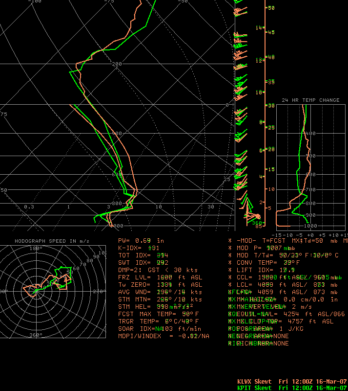
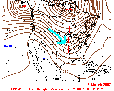
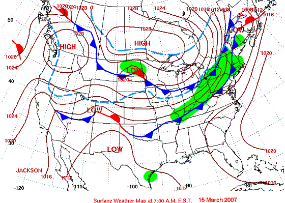
A late season snow storm blanketed Central PA with a general 6 to 10 inches of snow on Friday the 16th, the day before St. Patrick's Day, 2007. This storm developed quickly, as it developed along an old frontal boundary that produced some rain (that combined with snow melt to cause minor flooding), and even ended as some slushy snow in the Northern PA counties on Thursday (the 15th). However, the front had pushed well off to the south and east of PA on Friday morning, and the primary low pressure center developed in the Carolinas during the day on Friday (the 16th), moving to the northeast. Despite the placement of the surface low on Friday morning (just deepening over South Carolina), the deep easterly flow of moisture into the state Thursday Night and Friday Morning began producing light snowfall in the southern half of the state before sunrise on Friday. The jet stream then dipped sharply to the south over the Appalachian Mountains, and intensified the storm rapidly during the day on Friday. The snow started as a fine, needle-like snow for most of the area, with rain falling in York and Lancaster. The rain changed to sleet, then to snow, during the daylight hours over those lower Susquehanna Valley Areas, with New Holland (Eastern Lancaster County) not changing completely to snow until 8 pm Friday. The rest of the region saw the heaviest of the snow fall during the Afternoon and Evening on Friday, as the also snow became a heavier, wetter, more-dendritic snow. See the Skew-T, Log-P diagrams below for representative atmospheric soundings for KLWX (Sterling, VA) and KPIT (Pittsburgh, PA) at 12z Friday (8 am) and 00z on Saturday (8 pm EDT Friday). Note the warm layer aloft on Friday morning at both LWX and PIT, which gets erased by the evening, showing the change to a snow-supportive sounding/atmosphere.Maps & Figures
 |
 |
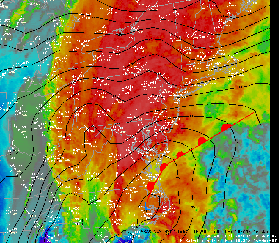 |
| Area Skew-T, Log-P Diagrams for 0000 UTC 3/17/2007 (8pm EDT, 16th) | Area Skew-T, Log-P Diagrams for 1200 UTC 3/16/2007 (8am EDT) | 2000UTC IR Satellite Picture 3/16/2007 (4pm EDT Friday) |
 |
 |
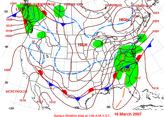 |
| US Upper Air Chart (500HPa), Friday Morning (3/16/2007), 1200UTC (8am EDT) | US Surface Chart, Thursday Morning (3/15/2007), 1200UTC (8am EDT) | US Surface Chart, Friday Morning (3/16/2007), 1200UTC (8am EDT) |
Storm Reports
NOUS41 KCTP 171717
PNSCTP
PAZ004>005-010>012-017>019-024>028-033>034-037-041>042-045>046-
049>053-056>059-063-065>066-180400-

PUBLIC INFORMATION STATEMENT
SPOTTER REPORTS
NATIONAL WEATHER SERVICE STATE COLLEGE PA
115 PM EDT SAT MAR 17 2007

THE FOLLOWING ARE UNOFFICIAL OBSERVATIONS TAKEN DURING THE STORM
THAT AFFECTED OUR REGION ON 16 MARCH 2007.  APPRECIATION IS EXTENDED
TO HIGHWAY DEPARTMENTS...COOPERATIVE OBSERVERS...SKYWARN SPOTTERS
THE MEDIA...AND THE PUBLIC FOR THESE REPORTS.  THIS SUMMARY IS ALSO
ON OUR HOME PAGE AT WEATHER.GOV/CTP

********************STORM TOTAL SNOWFALL********************

LOCATION          STORM TOTAL    TIME/DATE    COMMENTS
                     SNOWFALL       OF
                     (INCHES)   MEASUREMENT


PENNSYLVANIA

...ADAMS COUNTY...
   GETTYSBURG              8.0  1200 PM    3/17   PENNDOT
   NEW OXFORD              9.0   100 AM    3/17   PUBLIC REPORT
   ORRTANNA               10.0   848 PM    3/16   PUBLIC REPORT
   YORK SPRINGS            9.7   700 AM    3/17   PUBLIC REPORT

...BEDFORD COUNTY...
   BUFFALO MILLS           5.9   700 AM    3/17   COOP REPORT
   EVERETTE                5.7   700 AM    3/17   COOP REPORT
   SAXTON                  5.0   700 AM    3/17   COOP REPORT
   WOLFSBURG               5.0   700 AM    3/17   COOP REPORT

...BLAIR COUNTY...
   ALTOONA                 4.8   700 AM    3/17   COOP REPORT
   TYRONE                  4.0   700 AM    3/17   COOP REPORT
   WILLIAMSBURG            5.7   700 AM    3/17   COOP REPORT

...CAMBRIA COUNTY...
   JOHNSTOWN               7.8   400 AM    3/17   PUBLIC REPORT
   PRINCE GALLITZIN        8.3   700 AM    3/17   COOP REPORT

...CAMERON COUNTY...
   EMPORIUM                9.0   700 AM    3/17   COOP REPORT
   SINNEMAHONING           9.4   700 AM    3/17   COOP REPORT
   STEVENSON DAM          10.0   700 AM    3/17   COOP REPORT

...CENTRE COUNTY...
   BOALSBURG               8.0   932 PM    3/16   NWS EMPLOYEE
   CLARENCE               10.5   700 AM    3/17   COOP REPORT
   SPRING MILLS            9.0   632 AM    3/17   PUBLIC REPORT
   STATE COLLEGE           9.0   632 AM    3/17   PUBLIC REPORT
   PENN STATE              8.2   700 AM    3/17   COOP REPORT
   PHILIPSBURG 2S          7.7   700 AM    3/17   COOP REPORT

...CLINTON COUNTY...
   LOCK HAVEN              9.6   700 AM    3/17   COOP REPORT
   RENOVO                 10.0   700 AM    3/17   COOP REPORT

...CUMBERLAND COUNTY...
   CARLISLE                8.6   917 AM    3/17   PUBLIC REPORT
   ENOLA                   8.5   810 PM    3/16   PUBLIC REPORT
   NEW CUMBERLAND          8.0   857 PM    3/16   PUBLIC REPORT
   SHIPPENSBURG            6.2   700 AM    3/17   COOP REPORT
   SHIREMANSTOWN          10.5   923 PM    3/16   PUBLIC REPORT

...DAUPHIN COUNTY...
   DAUPHIN                 8.3   800 AM    3/17   PUBLIC REPORT
   DEHART DAM              6.0   700 AM    3/17   COOP REPORT
   ELIZABETHVILLE          9.8   926 AM    3/17   PUBLIC REPORT
   HARRISBURG              9.0   221 AM    3/17   PUBLIC REPORT
   HARRISBURG AIRPORT      9.5   700 AM    3/17   COOP REPORT
   HARRISBURG 1NE          7.0   700 AM    3/17   COOP REPORT
   HERSHEY                 8.0   700 AM    3/17   COOP REPORT
   MATAMORAS               7.0   700 PM    3/16   PUBLIC REPORT

...ELK COUNTY...
   RIDGWAY                 5.0   700 AM    3/17   COOP REPORT

...FRANKLIN COUNTY...
   GREENCASTLE             6.0   811 PM    3/16   PUBLIC REPORT
   UPPPER STRASBURG        7.5   700 AM    3/17   COOP REPORT

...HUNTINGDON COUNTY...
   HUNTINGDON              7.0   700 AM    3/17   COOP REPORT

...LANCASTER COUNTY...
   GLEN MOORE              2.5   700 AM    3/17   COOP REPORT
   HOLTWOOD                5.0   700 AM    3/17   COOP REPORT
   MARIETTA                9.0   243 AM    3/17   PUBLIC REPORT
   MILLERSVILLE            7.0   812 PM    3/16   PUBLIC REPORT
   NEW HOLLAND             4.4   700 AM    3/17   COOP REPORT
   SAFE HARBOR             4.0   700 AM    3/17   COOP REPORT

...LEBANON COUNTY...
   LEBANON                12.0  1043 AM    3/17   PUBLIC REPORT
   PALMYRA                 8.0   816 PM    3/16   PUBLIC REPORT

...LYCOMING COUNTY...
   HUGHESVILLE            10.4   700 AM    3/17   PUBLIC REPORT
   WILLIAMSPORT            9.7   700 AM    3/17   COOP REPORT

...MCKEAN COUNTY...
   CLERMONT                7.0   700 AM    3/17   COOP REPORT
   CYCLONE                 6.0   855 PM    3/16   PUBLIC REPORT
   KANE                    6.6   700 AM    3/17   COOP REPORT
   PORT ALLEGHENY         12.0   700 AM    3/17   COOP REPORT

...MONTOUR COUNTY...
   DANVILLE                7.0   700 AM    3/17   COOP REPORT

...NORTHUMBERLAND COUNTY...
   SHAMOKIN               12.0   812 PM    3/16   PUBLIC REPORT
   SUNBURY                 7.6   700 AM    3/17   COOP REPORT

...PERRY COUNTY...
   NEW BLOOMFIELD         8.0    831 PM    3/16   PUBLIC REPORT

...POTTER COUNTY...
   BROOKLAND             13.0    800 AM    3/17   PUBLIC REPORT
   COUDERSPORT           13.5    851 PM    3/16   COOP REPORT
   GALETON               11.2    900 AM    3/17   PUBLIC REPORT
   ROULETTE               6.0    813 PM    3/16   PUBLIC REPORT

...SCHUYLKILL COUNTY...
   ASHLAND                 9.2  1200 AM    3/17   PUBLIC REPORT
   MAHANOY CITY           10.2   700 AM    3/17   COOP REPORT
   PINE GROVE              9.0   700 AM    3/17   COOP REPORT
   SHENANDOAH HEIGHTS     10.6   800 AM    3/16   PUBLIC REPORT
   TAMAQUA                12.0   721 AM    3/17   PUBLIC REPORT

...SNYDER COUNTY...
   SELINSGROVE             8.0   700 AM    3/17   COOP REPORT

...SOMERSET COUNTY...
   CONFLUENCE              3.5   700 AM    3/17   COOP REPORT
   GLENCOE                 6.1   700 AM    3/17   COOP REPORT
   LAUREL SUMMIT           7.5   700 AM    3/17   COOP REPORT
   MEYERSDALE              5.0   700 AM    3/17   COOP REPORT
   MOUNT DAVIS             5.3   700 AM    3/17   COOP REPORT
   SOMERSET                5.8   700 AM    3/17   COOP REPORT

...SULLIVAN COUNTY...
   LAPORTE                10.0   700 AM    3/17   COOP REPORT

...TIOGA COUNTY...
   COVINGTON              10.1   700 AM    3/17   COOP REPORT
   COWANESQUE DAM          7.0   700 AM    3/17   COOP REPORT
   GAINES                  8.0   938 PM    3/16   PUBLIC REPORT
   SABINSVILLE             6.7   700 AM    3/17   COOP REPORT
   WELLSBORO               8.8   700 AM    3/17   COOP REPORT

...UNION COUNTY...
   LEWISBURG               7.0   700 AM    3/17   COOP REPORT
   LEWISBURG              10.0  1044 AM    3/17   PUBLIC REPORT
   MIFFLINBURG            10.5   800 AM    3/17   NWS EMPLOYEE

...WARREN COUNTY...
   CHANDLERS VALLEY        9.0   700 AM    3/17   COOP REPORT
   STARBRICK               6.0   100 PM    3/17   PENNDOT
   WARREN                  5.0   848 PM    3/16   PUBLIC REPORT


...YORK COUNTY...
   DOVER                  10.5   814 PM    3/16   PUBLIC REPORT
   HANOVER                10.4   213 AM    3/17   PUBLIC REPORT
   WELLSVILLE             10.0   815 PM    3/16   PUBLIC REPORT
   YORK HAVEN              6.0   700 AM    3/17   COOP REPORT
   YORK                   11.5   814 PM    3/16   PUBLIC REPORT

$$

CONNELLY
 |
Media use of NWS Web News Stories is encouraged! Please acknowledge the NWS as the source of any news information accessed from this site. |
|


 Send Us a Report