Overview
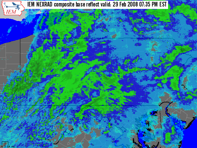
An Alberta Clipper moved through the State on Friday (Feb 29th) Afternoon and Evening, with some snow lingering after Midnight on Saturday, the 1st of March.
The Snowfall totals across the Laurel Mountains (Johnstown/Somerset) were impressive for just 12-15 hours worth of snowfall. Some un-official, public reports of over a foot of snow were received from those locations. The Laurel Summit NWS Co-Operative Observation Station had 10.0 inches of Snowfall, and the Ebensburg Station had 9.0 inches, for the 24 hour period ending 7 AM EST 03/01.
 |
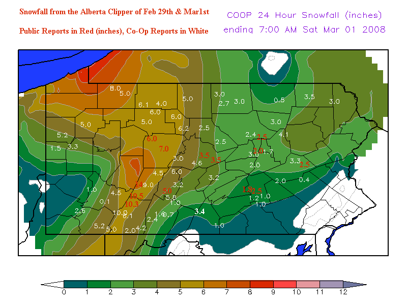 |
| Radar Loop for the Evening of Feb 29th | 24 Hour Co-Op Snowfall Map ending 7 AM EST 1Mar2008 |
Storm Reports
PUBLIC INFORMATION STATEMENT
SPOTTER REPORTS
NATIONAL WEATHER SERVICE STATE COLLEGE PA
1140 AM EST SAT MAR 1 2008

THE FOLLOWING ARE UNOFFICIAL OBSERVATIONS TAKEN DURING THE PAST 24
HOURS FOR THE STORM THAT HAS BEEN AFFECTING OUR REGION.
APPRECIATION IS EXTENDED TO HIGHWAY DEPARTMENTS...COOPERATIVE
OBSERVERS...SKYWARN SPOTTERS AND MEDIA FOR THESE REPORTS.  THIS
SUMMARY IS ALSO AVAILABLE ON OUR HOME PAGE AT WEATHER.GOV/CTP

********************STORM TOTAL SNOWFALL********************
LOCATION          STORM TOTAL    TIME/DATE    COMMENTS
                     SNOWFALL       OF
                     (INCHES)   MEASUREMENT

PENNSYLVANIA
...BEDFORD COUNTY...
   BUFFALO MILLS          2.4   753 AM   3/1
   WOLFSBURG              1.6   754 AM   3/1
   SAXTON                 1.0   754 AM   3/1
...BLAIR COUNTY...
   TYRONE                 6.0   755 AM   3/1
   ALTOONA                5.8   754 AM   3/1
   HOLLIDAYSBURG          5.0  1030 PM  2/29
   WILLIAMSBURG           3.2   756 AM   3/1
...CAMBRIA COUNTY...
   NANTY GLO             14.0   900 PM  2/29   TOWN OF CHICKORY
   WESTMONT              10.5   900 PM  2/29
   EBENSBURG              9.0   757 AM   3/1
   PRINCE GALLITZIN       4.5   758 AM   3/1
...CAMERON COUNTY...
   SINNEMAHONING          6.2   758 AM   3/1
   EMPORIUM               6.0   758 AM   3/1
...CENTRE COUNTY...
   STATE COLLEGE          4.6   700 AM   3/1
   PHILIPSBURG            4.0  1125 PM  2/29
   BELLEFONTE             3.5  1215 AM   3/1
   SPRING MILLS           3.5  1210 AM   3/1
   PLEASANT GAP           3.4  1200 AM   3/1
...CLEARFIELD COUNTY...
   CLEARFIELD             7.0   228 AM   3/1
   PENFIELD               6.0  1000 PM  2/29
...CLINTON COUNTY...
   LOCK HAVEN             2.5   701 AM   3/1
   RENOVO                 2.5   701 AM   3/1
...COLUMBIA COUNTY...
   BENTON                 4.1   701 AM   3/1
...DAUPHIN COUNTY...
   HARRISBURG             2.5   900 AM   3/1   PUBLIC REPORT
   DAUPHIN                1.8   901 AM   3/1   PUBLIC REPORT
   HERSHEY                1.0   702 AM   3/1
   MIDDLETOWN             0.5  1200 AM   3/1   AIRPORT
...ELK COUNTY...
   RIDGWAY                8.0   911 PM  2/29
   WILCOX                 6.0   703 AM   3/1
...FRANKLIN COUNTY...
   UPPER STRASBURG        3.4   704 AM   3/1
   SOUTH MOUNTAIN         1.0   704 AM   3/1
...LYCOMING COUNTY...
   MUNCY                  2.5   941 PM  2/29
   WILLIAMSPORT           2.4  1200 AM   3/1
...MCKEAN COUNTY...
   KANE                   6.1   705 AM   3/1
   CLERMONT               4.0   705 AM   3/1
...MIFFLIN COUNTY...
   LEWISTOWN              3.2   706 AM   3/1
...MONTOUR COUNTY...
   DANVILLE               1.7   706 AM   3/1
...NORTHUMBERLAND COUNTY...
   MONTANDON              2.0   758 AM   3/1   PUBLIC REPORT
...POTTER COUNTY...
   COUDERSPORT            5.0   707 AM   3/1
...SCHUYLKILL COUNTY...
   MAHANOY CITY           3.3   707 AM   3/1
   TAMAQUA                2.5   721 AM   3/1   PUBLIC REPORT
   PINE GROVE             2.0   707 AM   3/1
   ASHLAND                1.3   834 PM  2/29
...SNYDER COUNTY...
   MIDDLEBURG             4.5  1144 PM  2/29
   SELINSGROVE            2.0   708 AM   3/1
...SOMERSET COUNTY...
   BOSWELL               10.3   941 PM  2/29
   LAUREL SUMMIT         10.0   712 AM   3/1
   SOMERSET               6.1   713 AM   3/1
   CONFLUENCE             5.0   708 AM   3/1
   GLENCOE                4.2   712 AM   3/1
   MEYERSDALE             2.0   712 AM   3/1
...SULLIVAN COUNTY...
   LAPORTE                3.0   713 AM   3/1
...TIOGA COUNTY...
   COVINGTON              3.0   714 AM   3/1
   SABINSVILLE            3.0   715 AM   3/1
   WELLSBORO              2.7   715 AM   3/1
...UNION COUNTY...
   LEWISBURG              3.0   715 AM   3/1
...WARREN COUNTY...
   CHANDLERS VALLEY       8.0   716 AM   3/1
   WARREN                 5.0   716 AM   3/1
$$
 |
Media use of NWS Web News Stories is encouraged! Please acknowledge the NWS as the source of any news information accessed from this site. |
|


 Send Us a Report