Overview
Unseasonably warm and moist air over the region on Wednesday April 27th fueled severe thunderstorms. The thunderstorms occurred ahead of a cold front which would move through on Thursday morning. This was the same storm system responsible for the deadly outbreak of tornadoes across the Deep South that same evening and overnight. One tornado occurred in the evening of the 27th, and five more tornadoes occurred in Central PA after midnight in the early morning hours of April 28th, 2011. The strength of these tornadoes ranged from EF0 to EF2 on the Enhanced Fujita Scale.
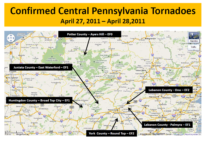 |
| Map of Confirmed Central PA Tornadoes |
Tornadoes:
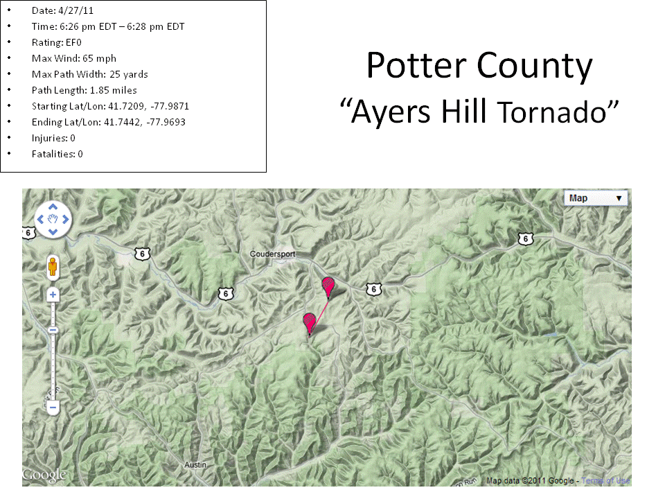
Tornado - Ayers Hill Tornado
Potter County
| Date |
4/27/11 |
| Time (Local) |
6:26 pm EDT - 6:28 pm EDT |
| EF Rating |
EF0 |
| Est. Peak Winds |
65 mph |
| Path Length |
25 yards |
| Max Width |
1.85 miles |
| Injuries/Deaths |
0/0 |
|
Summary:
A brief EF0 tornado skipped across southwest Potter County during the evening hours of 27 April 2011. Field surveys conducted by the NWS in State College and Potter County Emergency Management officials revealed that damaged caused by the tornado was minimal, only knocking down scattered to isolated trees along a two mile path. Due to lack of images and well-defined damage path, it is possible this tornado touch downed briefly in several locations.
|
Track Map
Downloadable KMZ File
|
Tornado - Broad Top City
Huntingdon County
| Date |
4/28/11 |
| Time (Local) |
2:20 am EDT - 2:25 am EDT |
| EF Rating |
EF1 |
| Est. Peak Winds |
90 mph |
| Path Length |
2.85 miles |
| Max Width |
50 yards |
| Injuries/Deaths |
0/0 |
|
Summary:
The NWS in State College confirmed an EF1 tornado near Broad Top City in southern Huntingdon County. The tornado produced sporadic damage. Numerous pine trees were uprooted along the 3-4 mile path, and two houses sustained minor damage. The damage indicators observed during the storm were consistent of wind speeds of 85 to 90 mph.
|
Track Map
.gif)
Downloadable KMZ File
|
| |
Tornado - East Waterford
Juniata County
| Date |
4/28/11 |
| Time (Local) |
2:53 am EDT - 3:00 am EDT |
| EF Rating |
EF1 |
| Est. Peak Winds |
110 mph |
| Path Length |
8.49 miles |
| Max Width |
100 yards |
| Injuries/Deaths |
0/0 |
|
Summary:
The NWS in State College confirmed an EF1 tornado near East Waterford in Juniata County. The EF1 tornado produced damage on the east side of East Waterford, then skirted northeast along SR 75 producing sporadic damage along a well-defined path from Honey Grove to Seven Pines in Spruce Hill Township. The Hancock farm in Honey Grove sustained significant damage. Numerous tree damage was observed. Two barns damaged along Laurel Run near SR 850 at Burnt Church Road. Additional barns SR 75 suffered minor to moderate roof damage, with roof debris scattered up to 200 yards away from source location.
|
| |
Track Map
.gif)
Downloadable KMZ File
|
| |
| |
Tornado - Round Top
York County
| Date |
4/28/11 |
| Time (Local) |
5:55 am EDT - 6:00 am EDT |
| EF Rating |
EF2 |
| Est. Peak Winds |
130 mph |
| Path Length |
2.62 miles |
| Max Width |
100 yards |
| Injuries/Deaths |
0/0 |
|
Summary:
The EF2 tornado touched-down on the slopes near the main ski lift, then traveled down (northeast) the slop into the parking lot and produced damage to several buildings and destroyed one outbuilding. The tornado knocked down numerous trees as it crossed Roundtop Road and continued to move northeast up the west-side of Pinetown Hill. The strongest winds were observed at the top of Pinetown Hill where a high voltage transmission wire tower was twisted and collapsed. The tornado continued to travel northeast down Pinetown Hill across Pinetown Road, snapping and uprooting trees. Near the end of the 2.5-3 mile track, one tree fell onto a house along Moores Mountain Road and destroyed a portion of the house.
|
Track Map
.gif)
Downloadable KMZ File
|
| |
| |
Tornado - Palmyra Tornado
Lebanon County
| Date |
4/28/11 |
| Time (Local) |
6:20 am EDT - 6:23 am EDT |
| EF Rating |
EF1 |
| Est. Peak Winds |
90 mph |
| Path Length |
1.92 miles |
| Max Width |
100 yards |
| Injuries/Deaths |
0/0 |
|
Summary:
The EF1 tornado first produced damage just west of South Lingle Avenue (SR 3017) near West Pajabon Drive and proceeded along a 2 mile path northeast of the Palmyra Shopping Center along East Main Street (U.S 422). Most of the damage indicators surveyed were associated with 75 to 85 mph winds, but a collapsed top floor of a house on 621 E. Main Street along with significant damage to an automobile dealership across the street supported maximum winds near 90mph.
|
| |
Track Map
.gif)
Downloadable KMZ File
|
Tornado - Ono
Lebanon County
| Date |
4/28/11 |
| Time (Local) |
6:30 am EDT - 6:33 am EDT |
| EF Rating |
EF2 |
| Est. Peak Winds |
115 mph |
| Path Length |
1.07 miles |
| Max Width |
200 yards |
| Injuries/Deaths |
0/0 |
|
Summary:
The EF2 tornado first produced damage near the intersection of Reeds Creek Road and Jonestown Road about a half-mile west of Ono or about 2 miles east of Harpers Tavern. The wind damage to trees in the valley parallel to Reeds Creek Road was extensive with many snapped or downed trees and utility poles. The 1 mile tornado path continued northeast crossed just north of I-81. In addition, two farms, a field warehouse and few residences sustained significant damage on a knoll just east of Reeds Creek Road. A pair of high tension towers were also knocked down with considerable damage visible from Reeds Creek Road. One cow was injured. In total, 4 homes suffered minor to moderate damage and 6 farm buildings were either damaged or destroyed. The damage indicators observed during the storm survey, particularly the damage of the high tension wire towers was consistent with 115mph.
|
Track Map
.gif)
Downloadable KMZ File
|
| |
| |
The Enhanced Fujita (EF) Scale classifies tornadoes into the following categories:
EF0
Weak
65-85 mph |
EF1
Moderate
86-110 mph |
EF2
Significant
111-135 mph |
EF3
Severe
136-165 mph |
EF4
Extreme
166-200 mph |
EF5
Catastrophic
200+ mph |
 |
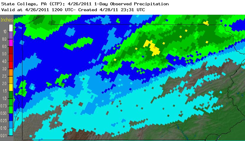
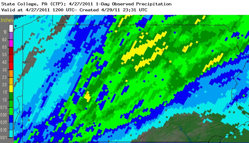
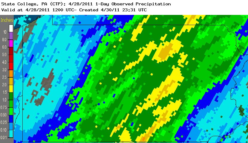
Rainfall Amounts
 |
 |
 |
Map of rainfall amounts for April 26th
|
Map of rainfall amounts for April 27th
|
Map of rainfall amounts for April 28th
|


 Send Us a Report