Overview
On June 11th, 2014, an EF-1 tornado with max winds around 95 mph touched down near Everett and crossed US Route 30. Its 11-mile damage path stretched from Everett northeast toward Hopewell. While the damage path was not continuous due to the tornado lifting up and touching back down multiple times, several trees were uprooted or snapped, and two homes and two barns were damaged. Fortunately, nobody was injured or killed during this event.
 |
 |
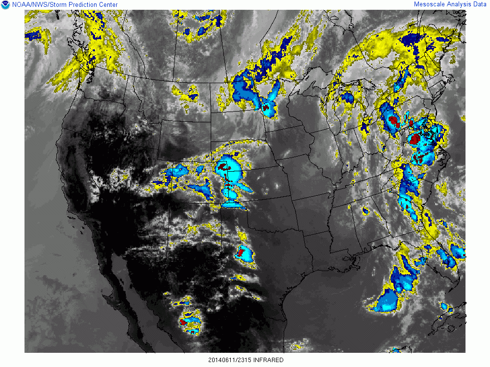 |
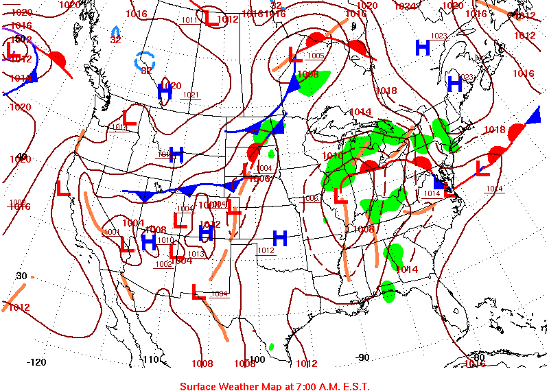
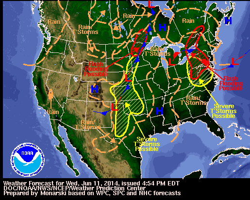
| WPC Daily Weather Map 6/11/14 | WPC National Forecast for Wed, June 11, 2014 | Infrared Satellite 23:15 UTC |
Tornadoes:
|
Tornado - Hopewell, Pennsylvania
Track Map 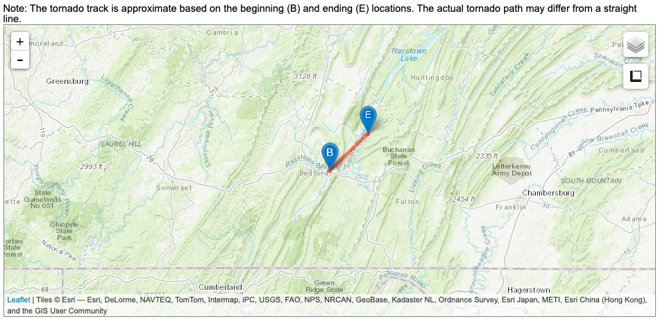 
|
||||||||||||||||
The Enhanced Fujita (EF) Scale classifies tornadoes into the following categories:
| EF0 Weak 65-85 mph |
EF1 Moderate 86-110 mph |
EF2 Significant 111-135 mph |
EF3 Severe 136-165 mph |
EF4 Extreme 166-200 mph |
EF5 Catastrophic 200+ mph |
 |
|||||
SPC
 |
 |
 |
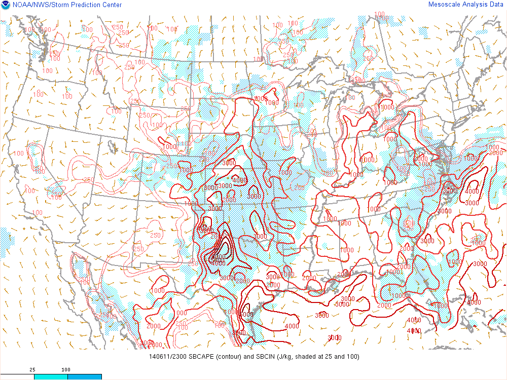
| SBCAPE and SBCIN 23:00 UTC | SPC Mesoscale Discussion | NWS SPC Tornado Watch | (source)
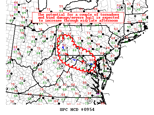
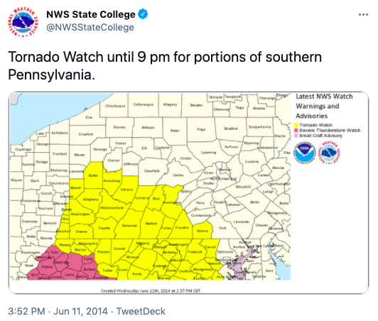
Mesoscale Discussion
MESOSCALE DISCUSSION 0954
NWS STORM PREDICTION CENTER NORMAN OK
1232 PM CDT WED JUN 11 2014
AREAS AFFECTED...SOUTHERN/WEST-CENTRAL PA AND PORTIONS OF
MD/NORTHERN VA/DC/WV PANHANDLE
CONCERNING...SEVERE POTENTIAL...WATCH LIKELY
VALID 111732Z - 111930Z
PROBABILITY OF WATCH ISSUANCE...80 PERCENT
SUMMARY...THE POTENTIAL FOR A COUPLE OF TORNADOES ALONG WITH
DAMAGING WINDS/SEVERE HAIL IS EXPECTED TO INCREASE THROUGH MID/LATE
AFTERNOON ACROSS SOUTHERN/WEST-CENTRAL PA AND PORTIONS OF
MD/NORTHERN VA/WV PANHANDLE AND THE DC METRO VICINITY. A WATCH IS
LIKELY BY AS EARLY AS MID-AFTERNOON.
DISCUSSION...LIKELY INFLUENCED BY OVERNIGHT CONVECTION/OUTFLOW...A
ZONE OF DIFFERENTIAL HEATING COINCIDES WITH A QUASI-STATIONARY
BOUNDARY THAT ANGLES FROM WESTERN/SOUTHERN PA EAST-SOUTHEASTWARD TO
EASTERN MD. THE AIR MASS ALONG /AND ESPECIALLY SOUTH OF/ THIS
BOUNDARY CONTINUES TO STEADILY WARM WHILE SOME INCREASE IN LOW-LEVEL
MOISTURE CONTINUES TO OCCUR /MIDDLE AND SOME UPPER 60S F SURFACE
DEWPOINTS/. CURRENT OBSERVATIONAL TRENDS/SHORT-TERM NUMERICAL
GUIDANCE INDICATE THAT THE STRONGEST DESTABILIZATION WILL CONTINUE
TO OCCUR ACROSS PARTS OF VA AND ADJACENT MD/WV...BUT AT LEAST 1000
J/KG MLCAPE WILL BECOME INCREASINGLY COMMON THROUGH MID/LATE
AFTERNOON COINCIDENT WITH MUCH OF THE FRONTAL ZONE. BENEATH A BELT
OF MODERATELY STRONG DEEP-LAYER SOUTHWESTERLY WINDS...GENERAL
PREVALENCE OF SOUTHEASTERLY NEAR-SURFACE WINDS WILL CONTRIBUTE TO A
MAXIMIZATION OF LOW-LEVEL SHEAR/SRH IN VICINITY OF THE BOUNDARY
WITHIN A RELATIVELY MOIST/LOW LCL ENVIRONMENT. AS SUCH...ANY STORMS
DEVELOPING NEAR AND/OR CROSSING THE BOUNDARY FROM THE WEST-SOUTHWEST
WILL LIKELY ATTAIN SUPERCELL CHARACTERISTICS WITH CORRESPONDING
POTENTIAL FOR A COUPLE OF TORNADOES AND SEVERE HAIL/WIND.
..GUYER/MEAD.. 06/11/2014
ATTN...WFO...CTP...LWX...PBZ...
LAT...LON 41038016 41137913 40507877 40177798 39767690 39257662
38627689 38577748 39227963 39768002 41038016
Storm Reports
445
NOUS41 KCTP 122055
PNSCTP
PAZ004>006-010>012-017>019-024>028-033>037-041-042-045-046-
049>053-056>059-063>066-130100-
PUBLIC INFORMATION STATEMENT
NATIONAL WEATHER SERVICE STATE COLLEGE PA
455 PM EDT THU JUN 12 2014
...TORNADO CONFIRMED NEAR EVERETT IN BEDFORD COUNTY
PENNSYLVANIA...
LOCATION...EVERETT TO HOPEWELL IN BEDFORD COUNTY PENNSYLVANIA
DATE...JUNE 11, 2014
ESTIMATED TIME...6:10 PM EDT
MAXIMUM EF-SCALE RATING...EF1
ESTIMATED MAXIMUM WIND SPEED...93 MPH
MAXIMUM PATH WIDTH...100 YARDS
PATH LENGTH...12 MILES
BEGINNING LAT/LON...40.02N/78.42W
ENDING LAT/LON...40.13N/78.31W
* FATALITIES...0
* INJURIES...0
* THE INFORMATION IN THIS STATEMENT IS PRELIMINARY AND SUBJECT TO
CHANGE PENDING FINAL REVIEW OF THE EVENT(S) AND PUBLICATION IN
NWS STORM DATA.
...SUMMARY...
THE NATIONAL WEATHER SERVICE IN STATE COLLEGE PA HAS CONFIRMED A
TORNADO NEAR EVERETT IN BEDFORD COUNTY PENNSYLVANIA ON JUNE 11,
2014.
DESPITE 3 VIDEOS SHOWING EVIDENCE THAT THE TORNADO TOUCHED DOWN
NEAR CENTERVILLE AT 546PM EDT...NO EVIDENCE OF WIND DAMAGE WAS
FOUND. HOWEVER...THE STORM PRODUCED QUARTER TO GOLFBALL SIZED HAIL
ALONG A 16 MILE PATH BETWEEN CENTERVILLE AND EVERETT.
THE TORNADO THEN CROSSED ROUTE 30 NEAR EVERETT AND BEGAN
PRODUCING DAMAGE ALONG A 12 MILE SKIPPING PATH. DAMAGE INCLUDED
UPROOTED AND SNAPPED TREES AS WELL AS STRUCTURAL DAMAGE TO TWO
HOMES AND TWO BARNS...ONE OF WHICH WAS DESTROYED. THE DESTROYED
BARN HAD NO DOORS WHICH LIKELY ALLOWED THE WIND TO DESTROY THE
STRUCTURE. THE TORNADO LIFTED NEAR HOPEWELL AROUND 720PM EDT.
THIS INFORMATION CAN ALSO BE FOUND ON OUR WEBSITE AT
WEATHER.GOV/CTP.
FOR REFERENCE...THE ENHANCED FUJITA SCALE CLASSIFIES TORNADOES
INTO THE FOLLOWING CATEGORIES:
EF0...WIND SPEEDS 65 TO 85 MPH.
EF1...WIND SPEEDS 86 TO 110 MPH.
EF2...WIND SPEEDS 111 TO 135 MPH.
EF3...WIND SPEEDS 136 TO 165 MPH.
EF4...WIND SPEEDS 166 TO 200 MPH.
EF5...WIND SPEEDS GREATER THAN 200 MPH.
$$
GRUMM/COLBERT
Tornado Warning
 |
Media use of NWS Web News Stories is encouraged! Please acknowledge the NWS as the source of any news information accessed from this site. |
|


 Send Us a Report