Overview
|
A widespread, long-lived thunderstorm line (bow echo) raced across western and central PA on the afternoon and early evening of 29 April 2025. The gusts associated with the line of storms reached above 80 MPH at times, producing widespread damage. A cold front was dropping down from the north across the lower Great Lakes. The thunderstorms which would eventually turn into the bow echo began to form over southern OH in the late morning hours. The storms became a line and began to bow out. The storms intensified as the bow moved across western PA in the afternoon. As it reached the Laurel Highlands, it was nearing it's peak intensity. It continued to be strong, holding very steady-state as it pushed through the entire width of the NWS State College Forecast Office's (WFO CTP) County Warning Area (CWA). Most of the damage was confined to an area between I-80 on the northern side and US Route 22 on the southern side. Per SPC & AMS: A derecho wind damage swath must extend either continuously or intermittently more than 400 miles (about 650 km) with a width of at least 60 miles (about 100 km). This criterion is used to eliminate more common, shorter-lived, and generally less-organized wind-producing convective systems. |
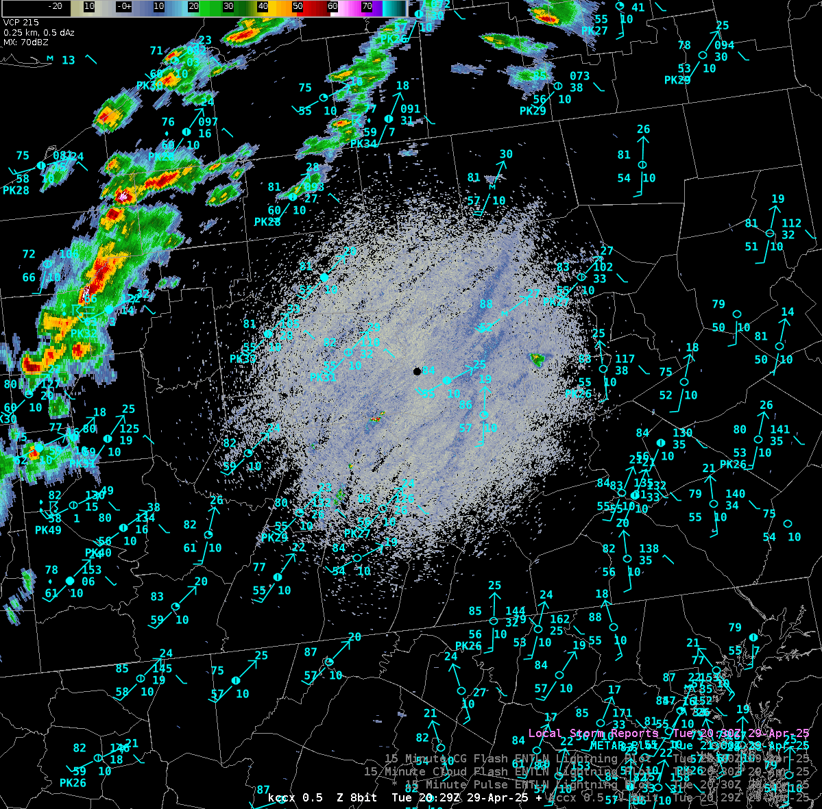
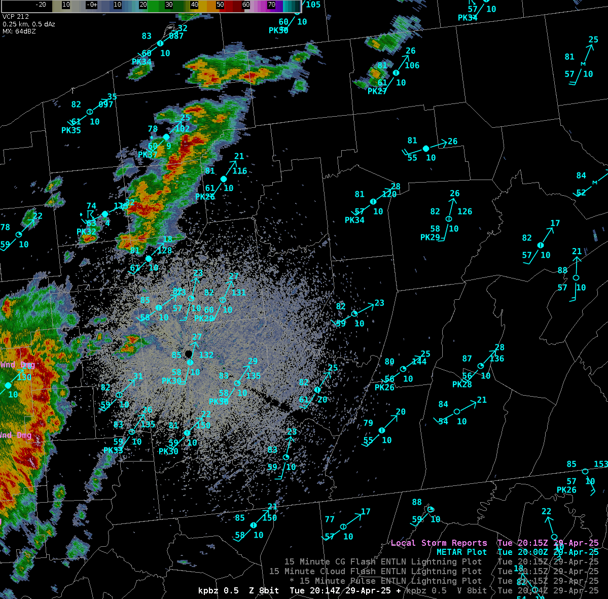
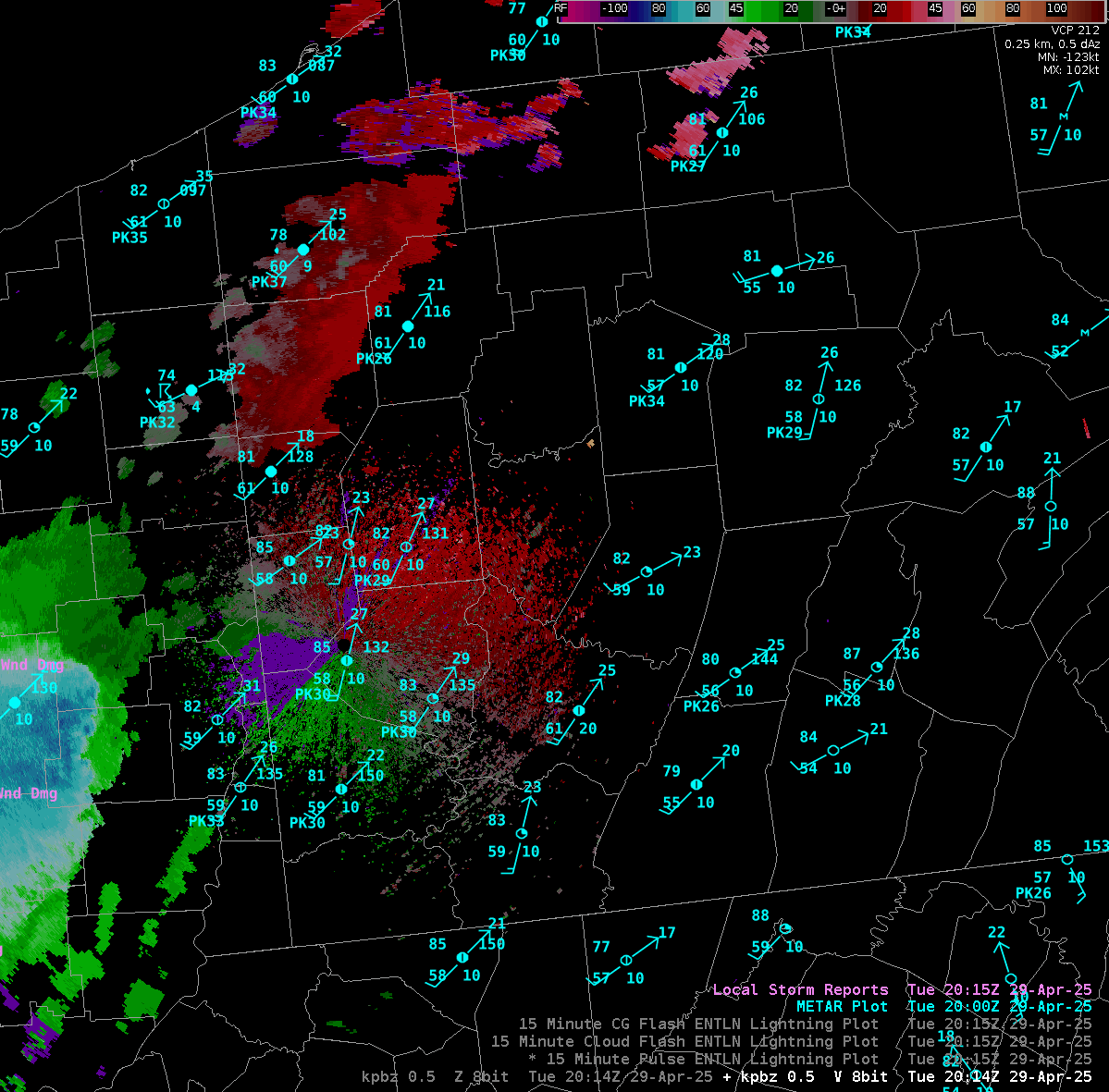
 Bow Echo on Radar |
||
|
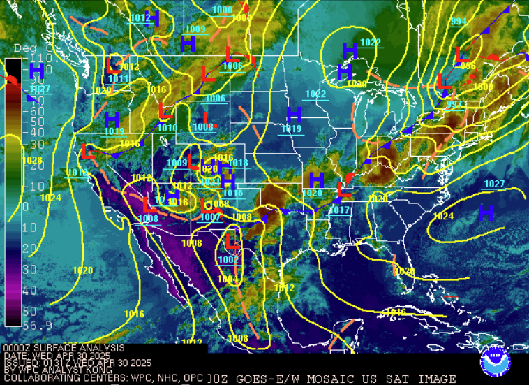
WPC Surface analysis at 8 PM EDT 29 April 2025 |
|||
 |
 |
.gif) |
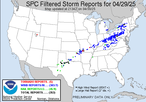
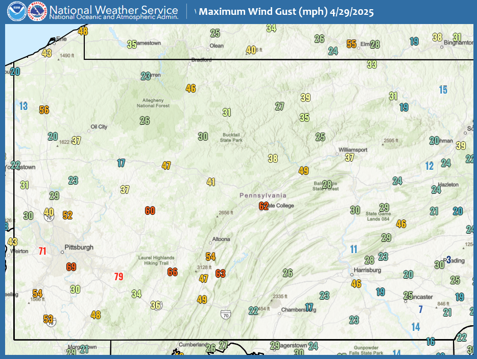
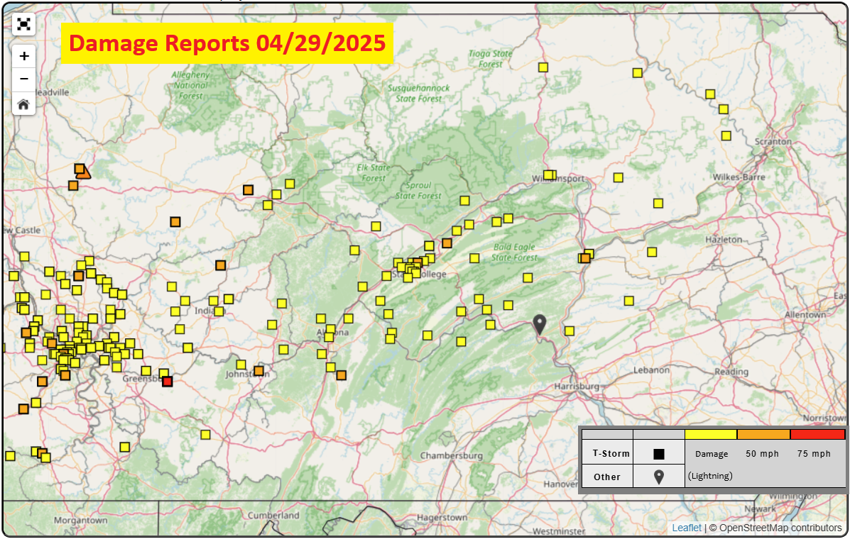
| Nationwide Damage Reports 4/29/2025 | Maximum Wind Gusts 4/29/2025 | Radar Loop with Lightning Highlighted |
Wind & Hail:
Wind
As the bow echo, which can be classified as a quasi linear convective system (QLCS) due to it's long and wide path, raced across Central PA at 70 MPH, it produced widespread wind damage. Some measured speeds were into the 80+ MPH range. A gust estimated to be 110-120 MPH knocked over a cellular antenna tower in Cambria County. Power outages continued into the next two days as cleanup from the storm was performed.
 |
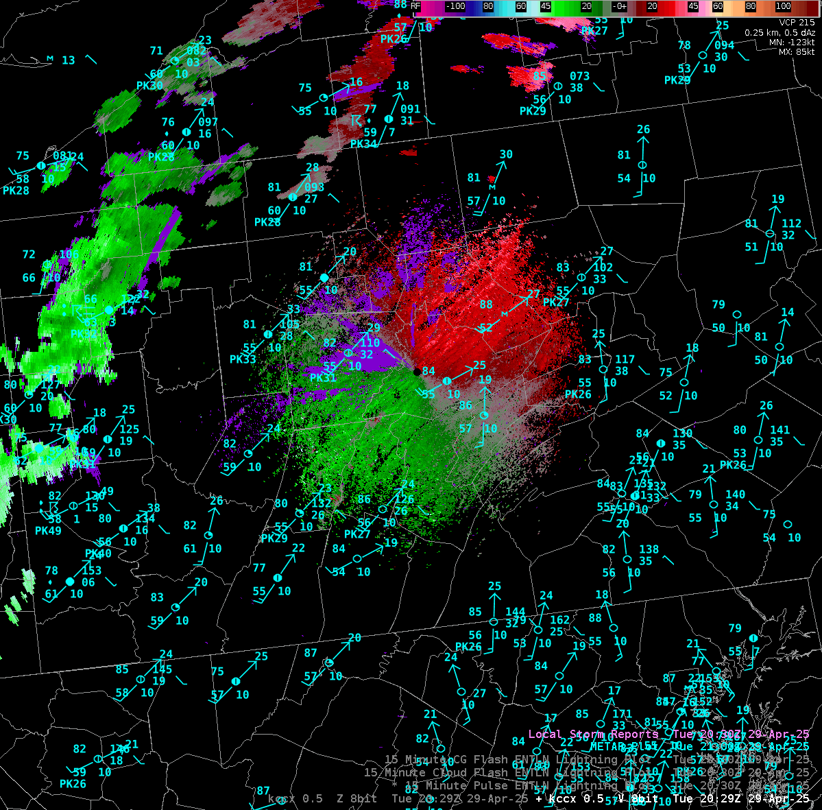 |
| KCCX Reflectivity Loop | KCCX Velocity Loop |
 |
 |
| KPBZ Reflectivity Loop | KPBZ Velocity Loop |
Storm Reports
Preliminary Local Storm Report...Summary
National Weather Service State College PA
900 PM EDT Wed Apr 30 2025

..TIME...   ...EVENT...      ...CITY LOCATION...     ...LAT.LON...
..DATE...   ....MAG....      ..COUNTY LOCATION..ST.. ...SOURCE....
            ..REMARKS..

0605 PM     Tstm Wnd Dmg     1 N Brownstown          40.35N 78.94W
04/29/2025                   Cambria            PA   911 Call Center

            Trees down on wires with a transformer down
            across North Sheridan Street in Johnstown.

0612 PM     Tstm Wnd Gst     2 NE Geistown           40.32N 78.83W
04/29/2025  M66 MPH          Cambria            PA   ASOS

            ASOS wind gust at KJST airport.

0612 PM     Tstm Wnd Dmg     2 ESE Colver            40.54N 78.75W
04/29/2025                   Cambria            PA   Storm Chaser

            Tree uprooted along Colver Road near
            Ebensburg.

0614 PM     Tstm Wnd Dmg     2 W Patton              40.64N 78.69W
04/29/2025                   Cambria            PA   Emergency Mngr

            Cell tower collapsed on Sunset Road.

0616 PM     Tstm Wnd Dmg     4 W Somerset            40.02N 79.16W
04/29/2025                   Somerset           PA   Utility Company

            Trees down across wires along Glades Pike
            Road.

0618 PM     Tstm Wnd Dmg     2 SSW Dubois            41.10N 78.78W
04/29/2025                   Clearfield         PA   911 Call Center

            Trees down on wires across Lincoln Drive in
            Dubois.

0618 PM     Tstm Wnd Dmg     2 WNW Cassandra         40.42N 78.68W
04/29/2025                   Cambria            PA   Emergency Mngr

            Reports of a barn collapse on the 800 block
            of Munster Road in Portage Township. Animals
            trapped inside of the collapse.

0628 PM     Tstm Wnd Dmg     5 NNE Horseshoe Curve   40.57N 78.45W
04/29/2025                   Blair              PA   Mesonet

            Trees and wires down across Wopsy Road near
            the lookout.

0630 PM     Tstm Wnd Dmg     2 S Treasure Lake       41.15N 78.72W
04/29/2025                   Clearfield         PA   Public

            Tree down onto a residence driveway with
            multiple large branches snapped off of
            trees.

0630 PM     Tstm Wnd Dmg     Newry                   40.40N 78.44W
04/29/2025                   Blair              PA   911 Call Center

            Tree fell onto a car with no injuries
            reported.

0631 PM     Tstm Wnd Dmg     1 WNW Lakemont          40.48N 78.40W
04/29/2025                   Blair              PA   911 Call Center

            Large tree with wires down near a residence
            and car, blocking entrances and exits.

0631 PM     Tstm Wnd Dmg     1 NNE Altoona           40.52N 78.39W
04/29/2025                   Blair              PA   911 Call Center

            Reports of a tree down on a residence on 7th
            Avenue. Multiple trees and wires down across
            Altoona.

0632 PM     Tstm Wnd Dmg     2 WSW Penfield          41.20N 78.64W
04/29/2025                   Clearfield         PA   911 Call Center

            Trees and wires knocked down onto a
            residence.

0635 PM     Tstm Wnd Dmg     2 W Philipsburg         40.89N 78.24W
04/29/2025                   Clearfield         PA   911 Call Center

            Trees down on wires along Decatur Street
            west of Philipsburg.

0635 PM     Tstm Wnd Dmg     1 WSW Sinking Valley    40.57N 78.28W
04/29/2025                   Blair              PA   911 Call Center

            Wires and telephone poles knocked down with
            three barn roofs blown off.

0637 PM     Tstm Wnd Dmg     2 SW Bald Eagle         40.72N 78.19W
04/29/2025                   Blair              PA   911 Call Center

            Reports of multiple trees into a residence
            with no injuries reported.

0638 PM     Tstm Wnd Dmg     Roaring Spring          40.34N 78.39W
04/29/2025                   Blair              PA   911 Call Center

            Multiple trees down in Roaring Spring.

0642 PM     Tstm Wnd Dmg     4 WSW Moshannon         41.00N 78.11W
04/29/2025                   Clearfield         PA   Amateur Radio

            Multiple trees and wires down in Grassflat.

0644 PM     Tstm Wnd Gst     1 SSE Martinsburg       40.30N 78.32W
04/29/2025  M63 MPH          Blair              PA   ASOS


0645 PM     Tstm Wnd Dmg     1 NE Petersburg         40.59N 78.03W
04/29/2025                   Huntingdon         PA   911 Call Center

            Trees down on wires along Route 305.

0646 PM     Tstm Wnd Dmg     1 WNW Franklinville     40.65N 78.08W
04/29/2025                   Huntingdon         PA   Amateur Radio

            Numerous trees and wires down along Spruce
            Creek Road.

0649 PM     Tstm Wnd Dmg     Huntingdon              40.50N 78.01W
04/29/2025                   Huntingdon         PA   911 Call Center

            Widepsread trees and wires down in
            Huntingdon. Power out at 911 center.

0649 PM     Tstm Wnd Dmg     2 SSE Port Matilda      40.77N 78.04W
04/29/2025                   Centre             PA   NWS Employee

            Trees down with snapped power poles.

0649 PM     Tstm Wnd Dmg     2 WNW Park Forest       40.81N 77.95W
04/29/2025                   Centre             PA   Amateur Radio

            Power poles snapped in Graysdale.

0650 PM     Tstm Wnd Dmg     1 NNW Raystown Dam      40.47N 78.02W
04/29/2025                   Huntingdon         PA   911 Call Center

            Tree knocked down onto a residence on
            Country Hills Drive. No injuries reported.

0650 PM     Tstm Wnd Dmg     4 WNW Park Forest       40.83N 77.97W
04/29/2025                   Centre             PA   NWS Employee

            Numerous trees down with one tree down on an
            outbuilding.

0651 PM     Tstm Wnd Dmg     1 NNW Park Forest       40.81N 77.91W
04/29/2025                   Centre             PA   911 Call Center

            Trees and wires down onto a residence on
            East Hillside Avenue. No injuries reported.

0651 PM     Tstm Wnd Dmg     3 S Park Forest         40.76N 77.91W
04/29/2025                   Centre             PA   Trained Spotter

            Numerous trees and wires down along Nixon
            Road. 66 MPH wind gust. Zero visibility
            ahead of the squall in blowing dust.

0652 PM     Tstm Wnd Gst     3 NNE State College     40.83N 77.85W
04/29/2025  M65 MPH          Centre             PA   NWS Employee

            65 MPH wind gust at the National Weather
            Service Office in State College.

0652 PM     Tstm Wnd Dmg     1 E Park Forest         40.80N 77.90W
04/29/2025                   Centre             PA   911 Call Center

            Tree down into an apartment building. No
            injuries reported.

0653 PM     Tstm Wnd Dmg     1 NNW State College     40.81N 77.86W
04/29/2025                   Centre             PA   Broadcast Media

            *** 1 INJ ***
            M52 mph tstm wind gust @PSU Beaver Stadium
            WeatherSTEM lofted portable restroom into
            student referee causing minor injuries.
            Video Credit: Barstool Penn State.

0656 PM     Tstm Wnd Gst     Zion                    40.92N 77.67W
04/29/2025  M61 MPH          Centre             PA   Public


0657 PM     Tstm Wnd Dmg     1 W State College       40.79N 77.88W
04/29/2025                   Centre             PA   Public

            Large trees knocked down on Hillcrest Avenue
            near West Cherry Lane and Orlando Avenue.

0657 PM     Tstm Wnd Dmg     4 NE State College      40.84N 77.81W
04/29/2025                   Centre             PA   Public

            Reports of roof and structural damage
            northeast of Houserville.

0657 PM     Tstm Wnd Dmg     3 NE Park Forest        40.83N 77.88W
04/29/2025                   Centre             PA   911 Call Center

            Power line down on a vehicle with multiple
            trees down in the vicinity of Cricklewood
            Drive and Fox Hollow Road.

0658 PM     Tstm Wnd Dmg     1 WSW State College     40.79N 77.87W
04/29/2025                   Centre             PA   911 Call Center

            Reports of a tree on a residence with a tree
            also down in a yard near the intersection of
            South Patterson Street and South Sparks
            Street.

0658 PM     Tstm Wnd Dmg     Bellefonte              40.91N 77.78W
04/29/2025                   Centre             PA   Public

            Tree down onto an apartment building in
            Bellefonte. No injuries reported.

0658 PM     Tstm Wnd Dmg     Bellefonte              40.91N 77.78W
04/29/2025                   Centre             PA   Trained Spotter

            Trees and wires down in Bellefonte.

0659 PM     Tstm Wnd Dmg     2 WSW Pleasant Gap      40.85N 77.77W
04/29/2025                   Centre             PA   Trained Spotter

            Trees and wires down across College Avenue
            near Pleasant Gap.

0700 PM     Tstm Wnd Dmg     1 S State College       40.78N 77.86W
04/29/2025                   Centre             PA   Trained Spotter

            At least 9 power poles snapped with
            wires/poles on roadway along West College
            Ave near Cato Drive and Whitehall Road,
            Ferguson Township. At least two occupied
            vehicles covered with downed wires.

0703 PM     Tstm Wnd Dmg     3 WSW Mcveytown         40.49N 77.79W
04/29/2025                   Mifflin            PA   Trained Spotter

            Multiple trees down on Ferguson Valley Rd.
            Time estimated using radar.

0708 PM     Tstm Wnd Dmg     4 NNE Beech Creek       41.12N 77.56W
04/29/2025                   Clinton            PA   Emergency Mngr

            Reports of a barn collapse on the 1000 block
            of Dry Run Road with debris from the
            collapse blocking the roadway.

0709 PM     Tstm Wnd Dmg     1 W Lamar               41.01N 77.53W
04/29/2025                   Clinton            PA   Utility Company

            Widespread trees and wires down near Lamar.

0709 PM     Tstm Wnd Dmg     3 SE Howard             40.98N 77.61W
04/29/2025                   Centre             PA   Public

            Multiple trees snapped and uprooted
            southeast of Howard.

0711 PM     Tstm Wnd Dmg     Lewistown               40.60N 77.58W
04/29/2025                   Mifflin            PA   911 Call Center

            Trees down on wires across West 3rd Street
            in Lewistown.

0711 PM     Tstm Wnd Dmg     1 NNW Poe Valley State  40.85N 77.50W
04/29/2025                   Centre             PA   911 Call Center

            Multiple trees reported down south of
            Millheim.

0715 PM     Tstm Wnd Dmg     Alfarata                40.66N 77.47W
04/29/2025                   Mifflin            PA   911 Call Center

            Numerous trees and wires down along Route
            522 near Alfarata.

0719 PM     Tstm Wnd Dmg     3 NNW Honey Grove       40.46N 77.58W
04/29/2025                   Juniata            PA   911 Call Center

            Multiple trees down on wires across McKinley
            Road near Honey Grove.

0719 PM     Tstm Wnd Dmg     3 WSW Loganton          41.02N 77.36W
04/29/2025                   Clinton            PA   911 Call Center

            Trees down on a barn near West Valley Road.

0720 PM     Tstm Wnd Dmg     3 NNW Mifflintown       40.61N 77.42W
04/29/2025                   Juniata            PA   911 Call Center

            Multiple trees down blocking the roadway on
            Arch Rock Road.

0723 PM     Tstm Wnd Dmg     1 NE Loganton           41.04N 77.29W
04/29/2025                   Clinton            PA   Emergency Mngr

            High tension wires knocked down in the
            vicinity of Whitetail Trail.

0725 PM     Tstm Wnd Dmg     1 WNW Port Royal        40.54N 77.40W
04/29/2025                   Juniata            PA   Amateur Radio

            Trees down across and blocking Route 333
            near Port Royal.

0726 PM     Tstm Wnd Dmg     1 WSW Mcalisterville    40.63N 77.29W
04/29/2025                   Juniata            PA   911 Call Center

            Multiple trees down near the intersection of
            Thompson Road and Route 35 North.

0729 PM     Tstm Wnd Dmg     Beavertown              40.76N 77.17W
04/29/2025                   Snyder             PA   Utility Company

            Numerous trees down across wires in
            Beavertown.

0730 PM     Tstm Wnd Dmg     Covington               41.74N 77.07W
04/29/2025                   Tioga              PA   911 Call Center

            Trees down 2800 block Rt 660, Covington
            Township.

0740 PM     Lightning        3 ENE Millerstown       40.57N 77.11W
04/29/2025                   Perry              PA   911 Call Center

            Lightning struck a lightning pole, knocking
            power out across the area and catching a
            nearby tree on fire.

0740 PM     Tstm Wnd Dmg     1 W Williamsport        41.24N 77.04W
04/29/2025                   Lycoming           PA   911 Call Center

            Trees down 900 block Wildwood Ave.

0745 PM     Tstm Wnd Dmg     Williamsport            41.24N 77.02W
04/29/2025                   Lycoming           PA   911 Call Center

            Multiple reports of trees and wires down in
            Williamsport.

0746 PM     Tstm Wnd Dmg     1 N Sunbury             40.87N 76.79W
04/29/2025                   Northumberland     PA   Emergency Mngr

            Reports of a building collapse on Julia
            Street in Sunbury.

0746 PM     Tstm Wnd Dmg     1 N Sunbury             40.87N 76.79W
04/29/2025                   Northumberland     PA   911 Call Center

            Trees and wires down in Sunbury.

0747 PM     Tstm Wnd Dmg     Shamokin Dam            40.85N 76.83W
04/29/2025                   Snyder             PA   911 Call Center

            Numerous trees and wires down along Route
            15.

0747 PM     Tstm Wnd Gst     1 E Shamokin Dam        40.85N 76.81W
04/29/2025  M68 MPH          Northumberland     PA   Dept of Highways

            Measured wind on the Route 147 bridge near
            the Fabridam.

0757 PM     Tstm Wnd Dmg     3 SE Millersburg        40.51N 76.91W
04/29/2025                   Dauphin            PA   911 Call Center

            Multiple trees down in Halifax Township,
            blocking roadways.

0758 PM     Tstm Wnd Dmg     Lairdsville             41.23N 76.61W
04/29/2025                   Lycoming           PA   Emergency Mngr

            Reports of a roof blowing of a structure on
            the 6000 block of State Route 118. The roof
            blowing off also knocked over a 1000 gallon
            propane tank.

0805 PM     Tstm Wnd Dmg     1 SW Valley View        40.65N 76.54W
04/29/2025                   Schuylkill         PA   911 Call Center

            Numerous trees and wires down in Valley
            View.

0805 PM     Tstm Wnd Dmg     3 S Stillwater          41.11N 76.36W
04/29/2025                   Columbia           PA   911 Call Center

            Trees and wires down along Route 487.

0806 PM     Tstm Wnd Dmg     1 SSE Numidia           40.88N 76.40W
04/29/2025                   Columbia           PA   Utility Company

            Trees and wires down along Route 42 in
            Numidia.


&&

$$
Environment
 |
 |
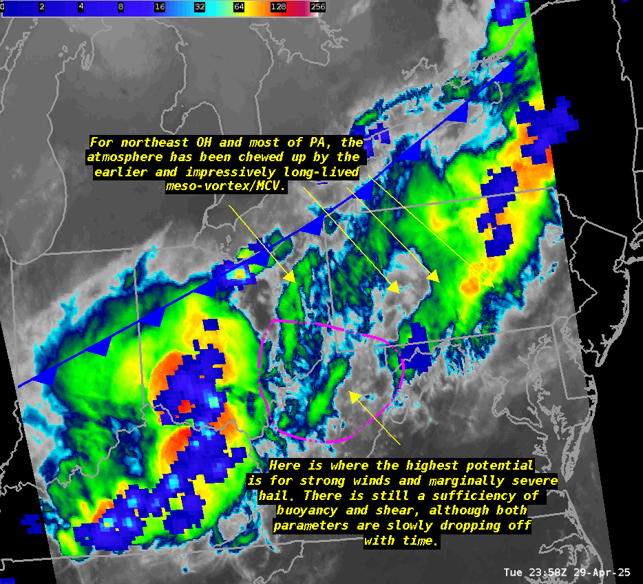 |
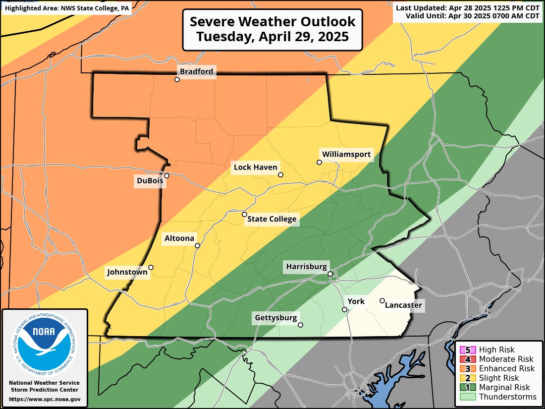
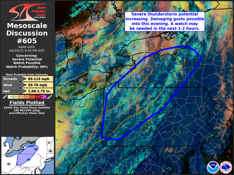
| SPC Severe Weather Outlook Day 1 | SPC Mesoscale Discussion before the storms began | Late-Event Near-storm Environment Update |
 |
Media use of NWS Web News Stories is encouraged! Please acknowledge the NWS as the source of any news information accessed from this site. |
|


 Send Us a Report