Hurricane Isaias Approaching the Gulf Coast; Remnants of Rachel to Impact the Southwest U.S.
Hurricane Isaias is expected to make landfall along the U.S. northern Gulf Coast late Friday or early Saturday. A life-threatening storm surge is expected along the coast with damaging wind gusts extending well inland. Areas of heavy rainfall are forecast throughout much of the Southeast U.S. The remnants of Rachel will bring gusty winds and heavy rainfall to the Southwest U.S. this weekend.
Read More >
...NWS Damage Survey for 09/01/2026 Tornado Event...

.Gaines Township Tornado...

Rating: EF-1
Estimated Peak Wind: 110 mph
Path Length /statute/: 6.5 miles
Path Width /maximum/: 150 yards
Fatalities: 0
Injuries: 0

Start Date: 09/01/2026
Start Time: 05:33 PM EDT
Start Location: 4 W Gaines / Potter County / PA
Start Lat/Lon: 41.794 / -77.6155

End Date: 09/01/2026
End Time: 05:48 PM EDT
End Location: 4 ESE Galeton / Tioga County / PA
End Lat/Lon: 41.7082 / -77.5748

Survey Summary:
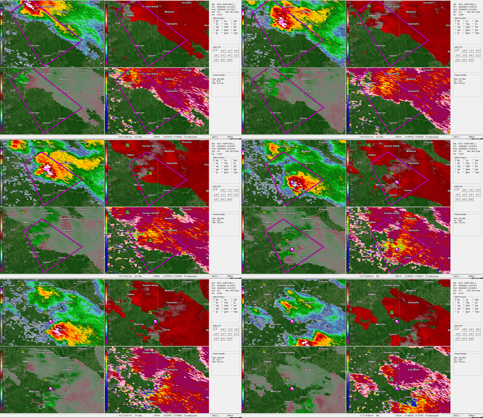
On September 1, 2026 at approximately 5:33 PM EDT, an EF-1
tornado impacted areas of eastern Potter County and western Tioga
County in the vicinity of Gaines Township. Maximum wind speeds
were estimated at 110 mph with a maximum path width of 150 yards.

Damage associated with the tornado began north of Galeton near
Phoenix Run in Pike Township, where multiple hardwood trees were
snapped along with numerous large branches on both sides of
Phoenix Road. There was more extensive damage just east of Phoenix
Road, where a larger swath of EF-1 damage was observed with some
uprooted trees alongside snapped trees and large branches. Damage
continued southeastward on Phoenix Road in Potter County with more
sporadic damage including broken large branches and snapped
trees. There was an area where the tornado potentially lifted as
it approached US Route 6 with damage being largely sporadic and
not as concentrated as it crossed the roadway.

Once crossing US Route 6, more widespread damage was observed
across Hanky Panky Road in Gaines Township, Tioga County. Numerous
uprooted and snapped trees were observed across approximately a
150 yard segment with eyewitnesses mentioning that there were
trees across the roadway in a convergent pattern. This damage
continued towards the intersections of Dingman Road and Bloody Run
Road, where concentrated areas of snapped and uprooted trees
continued to be observed. There was another eyewitness that noted
multiple trees uprooted at their residence on Dingman Road with
what appeared to be a convergent pattern. As the storm continued
into Marshlands, multiple large branches as well as uprooted and
snapped trees were in a convergent pattern, with surrounding
vegetation also outlining a convergent pattern. The tornado likely
continued to parallel Elk Run Road just south of the roadway
before dissipating on the north side of the intersection with
Straight Run Road.

We would like to thank Gaines Township Emergency Management,
Tioga County Emergency Management, multiple first responders, and
the multiple eyewitnesses from Gaines Township for their
assistance with this damage survey.

&&

EF Scale: The Enhanced Fujita Scale classifies tornadoes into the
following categories:

EF0.....65 to 85 mph
EF1.....86 to 110 mph
EF2.....111 to 135 mph
EF3.....136 to 165 mph
EF4.....166 to 200 mph
EF5.....>200 mph

NOTE:
The information in this statement is preliminary and subject to
change pending final review of the event and publication in
NWS Storm Data.
Pictures:
Radar Images:
Details:
...NWS Damage Survey for 09/01/2026 Tornado Event...

.Derry Township Tornado...

Rating:                 EF-1
Estimated Peak Wind:    100 mph
Path Length /statute/:  0.87 miles
Path Width /maximum/:   250 yards
Fatalities:             0
Injuries:               0

Start Date:             09/01/2026
Start Time:             05:40 PM EDT
Start Location:         2 ESE Washingtonville / Montour County / PA
Start Lat/Lon:          41.0343 / -76.648

End Date:               09/01/2026
End Time:               05:41 PM EDT
End Location:           2 ESE Washingtonville / Montour County / PA
End Lat/Lon:            41.0322 / -76.6321

Survey Summary:
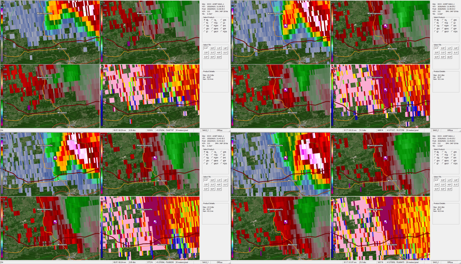
During the evening of September 1st, 2026, a supercell
thunderstorm moved southeastward through Montour County, resulting
in a brief EF-1 tornado, which impacted southern portions of the
county in Derry Township. We also found damage due to a downburst
that occurred on the north side of the tornado, associated with
the forward flank downdraft of this supercell. Maximum wind speeds
from this tornado were estimated to be 100 mph, and the tornado
had a maximum path width of 250 yards. Tornadic damage was first
noted in the woods between Steffens Rd and Indian Run Rd, with a
start time of 5:40 PM local time. The tornadic damage was
primarily on Stable Ln and the hairpin turn on Indian Run Rd. In
this location, two large trees snapped and fell on a shed, with a
trail of snapped and uprooted trees into the woods beyond the
property. The tornado continued eastward before dissipating near
Fossil Hill Rd at 5:41 PM local time. Surrounding this track,
numerous trees were snapped and uprooted from straight-line winds,
making a broadly divergent pattern particularly to the north of
the tornado path.

We would like to thank Montour County Emergency
Management, local homeowners, and other members of the local
community for their assistance in this damage survey.

&&

EF Scale: The Enhanced Fujita Scale classifies tornadoes into the
following categories:

EF0.....65 to 85 mph
EF1.....86 to 110 mph
EF2.....111 to 135 mph
EF3.....136 to 165 mph
EF4.....166 to 200 mph
EF5.....>200 mph

NOTE:
The information in this statement is preliminary and subject to
change pending final review of the event and publication in
NWS Storm Data.
Pictures:
Radar Images:
Details:
Public Information Statement
National Weather Service State College PA
842 PM EDT Fri Sep 4 2026

...NWS Damage Survey for 09/01/2026 Tornado Event...

.Salisbury Township Tornado...

Rating:                 EF1
Estimated Peak Wind:    90 mph
Path Length /statute/:  1.08 miles
Path Width /maximum/:   100 yards
Fatalities:             0
Injuries:               0

Start Date:             09/01/2026
Start Time:             07:44 PM EDT
Start Location:         4 NNE Gap / Lancaster County / PA
Start Lat/Lon:          40.034 / -75.9802

End Date:               09/01/2026
End Time:               07:48 PM EDT
End Location:           3 NE Gap / Lancaster County / PA
End Lat/Lon:            40.0189 / -75.9781

Survey Summary:
At 7:44 p.m. local time on September 1, 2026 an EF-1 tornado,
with maximum wind speeds of 90 mph, touched down in Salisbury
Township northwest of the Mount Vernon Road and Old Philadelphia
Pike intersection with a width of 100 yards. It traveled south as
it ripped off the roof of a barn and threw sections through the
Old Road Mennonite Church graveyard before crossing Old
Philadelphia Pike and paralleling Mount Vernon Road. It ripped a
roof off another barn and snapped many larger limbs from a tree
in the neighboring pasture. Continuing south it took some
sections of roof and loose items from three farm outbuildings and
ejected them throughout the fields. As it continued along Mount
Vernon Road, a clump of trees was hit where many trees were
uprooted and large branches snapped. Farther south, a barn
sustained some minor roof damage before a one room school house
was impacted with its whole roof torn off. At the intersection of
Buena Vista Road and Mount Vernon Road, another tree was uprooted
and a telephone pole was bent. It continued south to the east of
Mount Vernon Road where it crossed Pequea Creek, snapping many
large branches and uprooting a few more trees. Past the creek,
another clump of trees saw large branches snapped before the
tornado dissipated in a field.

We would like to thank Lancaster County Emergency Management and
Salisbury Township officials for their assistance in this damage
survey.

&&

EF Scale: The Enhanced Fujita Scale classifies tornadoes into the
following categories:

EF0.....65 to 85 mph
EF1.....86 to 110 mph
EF2.....111 to 135 mph
EF3.....136 to 165 mph
EF4.....166 to 200 mph
EF5.....>200 mph

NOTE:
The information in this statement is preliminary and subject to
change pending final review of the event and publication in
NWS Storm Data.










 Radar
Radar Current Weather
 Rivers & Lakes
 Satellite
 Forecast Maps
 Hour by Hour Forecast
 Tropical Weather
 Graphical Hazards
 Weather Hazards Briefing
 Fire Weather
 Text Forecasts and Statements
 Forecaster's Discussion
 Send Us a Report
 KCCX Local Radar (Hi-Res)
 Drought
 Winter
 Follow us on X
 Follow us on Facebook
 CTP RSS Feed