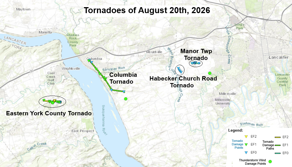
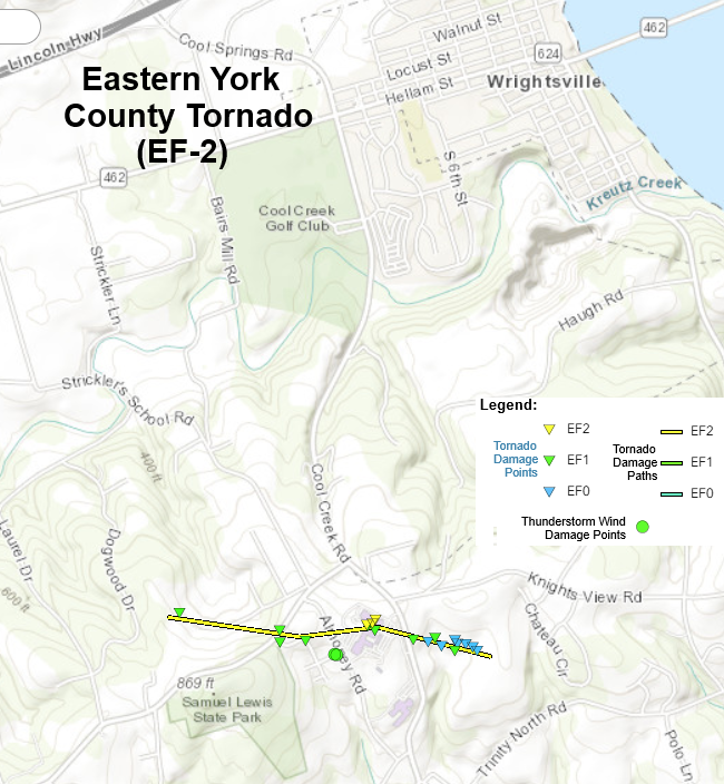
..Eastern York County Tornado...

Rating:                 EF2
Estimated Peak Wind:    120 mph
Path Length /statute/:  1.07 miles
Path Width /maximum/:   100 yards
Fatalities:             0
Injuries:               1

Start Date:             08/20/2026
Start Time:             04:24 PM EDT
Start Location:         2 SSW Wrightsville / York County / PA
Start Lat/Lon:          39.9994 / -76.5521

End Date:               08/20/2026
End Time:               04:26 PM EDT
End Location:           2 SSE Wrightsville / York County / PA
End Lat/Lon:            39.9975 / -76.5323

Survey Summary:
An EF-2 tornado impacted eastern York County during the afternoon
of August 20, 2026. Maximum wind speeds were estimated to be 120
mph and the tornado had a maximum path width of 100 yards. Damage
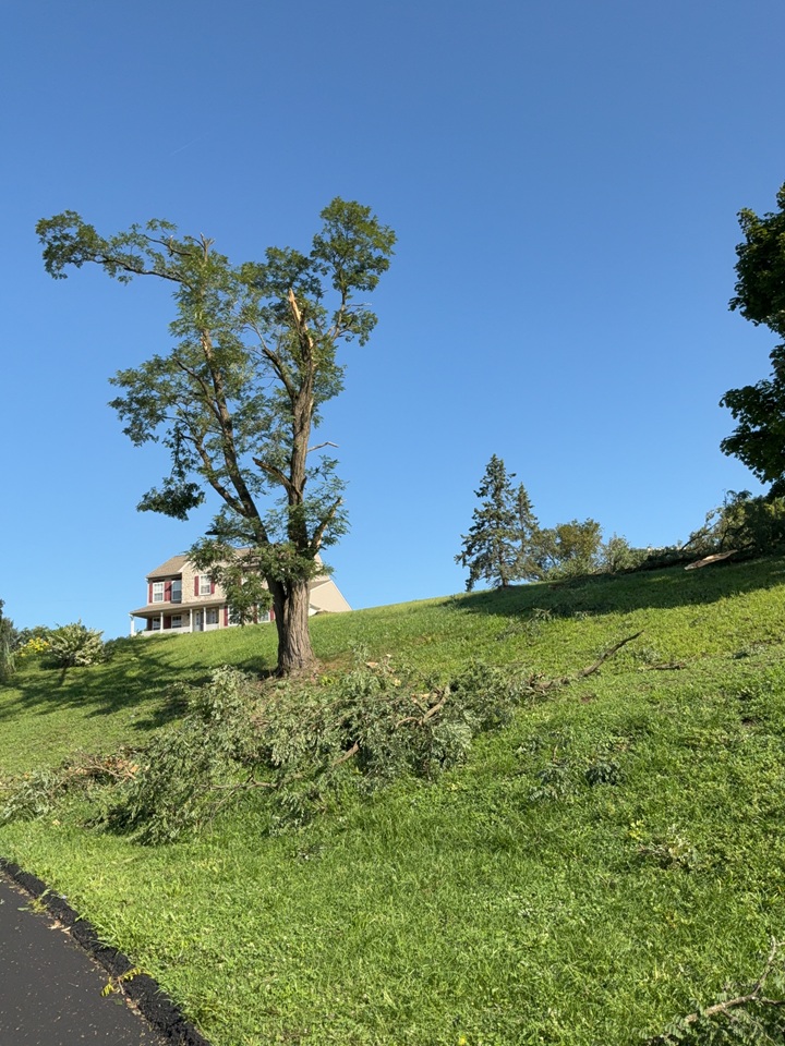
was first noted near the end of Vista Lane near Wrightsville where
approximately 5 trees were snapped. Sporadic tree damage was
noted along the tornado`s track as it continued towards
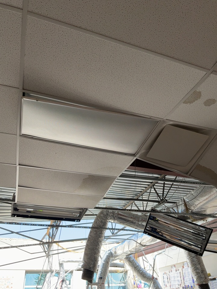
Picturesque Drive. The most significant damage occurred at Eastern
York High School where the roof was fully ripped off of multiple
classrooms. There was also significant damage to the school`s
auditorium, with the roof partially ripped off and bricks at the
top of the wall shifted from their original location. The tornado
continued eastward along Winding Way, where multiple homes
sustained damage to windows and siding. One injury was reported as
a result of a window being blown into a house. The tornado
knocked down crops in a field to the east of these houses, before
lifting prior to reaching Chateau Circle.

We would like to thank York County Emergency Management and local
homeowners for their assistance in this damage survey.


EF Scale: The Enhanced Fujita Scale classifies tornadoes into the
following categories:

EF0.....65 to 85 mph
EF1.....86 to 110 mph
EF2.....111 to 135 mph
EF3.....136 to 165 mph
EF4.....166 to 200 mph
EF5.....>200 mph

NOTE:
The information in this statement is preliminary and subject to
change pending final review of the events and publication in
NWS Storm Data.


$$
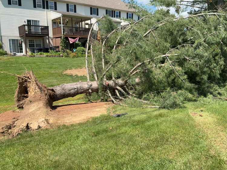
Damage Pictures:
Radar Images:
...NWS Damage Survey for 08/20/26 Tornado Event - Update #2...

.Update...
Based on additional drone footage, NWS State College has extended
the length of the Columbia EF-1 tornado and added an additional
short EF-0 tornado (now 4 total) from the storms that moved
through southeast PA on August 20, 2026.

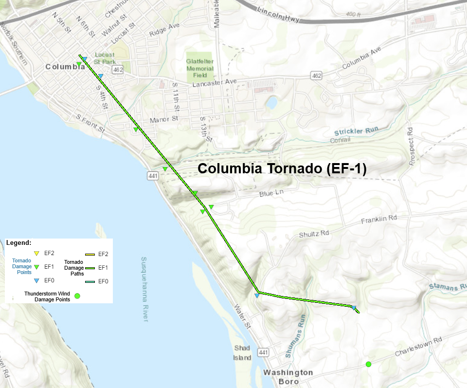
..Columbia Tornado...

Rating:                 EF1
Estimated Peak Wind:    100 mph
Path Length /statute/:  3.01 miles
Path Width /maximum/:   100 yards
Fatalities:             0
Injuries:               0

Start Date:             08/20/2026
Start Time:             04:30 PM EDT
Start Location:         Columbia / Lancaster County / PA
Start Lat/Lon:          40.0343 / -76.5015

End Date:               08/20/2026
End Time:               04:33 PM EDT
End Location:           2 SE Columbia / Lancaster County / PA
End Lat/Lon:            40.0031 / -76.4620

Survey Summary:
On August 20, 2026 at approximately 4:30 p.m. EDT, an EF-1 tornado
impacted Columbia, PA. Maximum wind speeds were estimated at 100
mph with a maximum path width of 100 yards. The damage path began
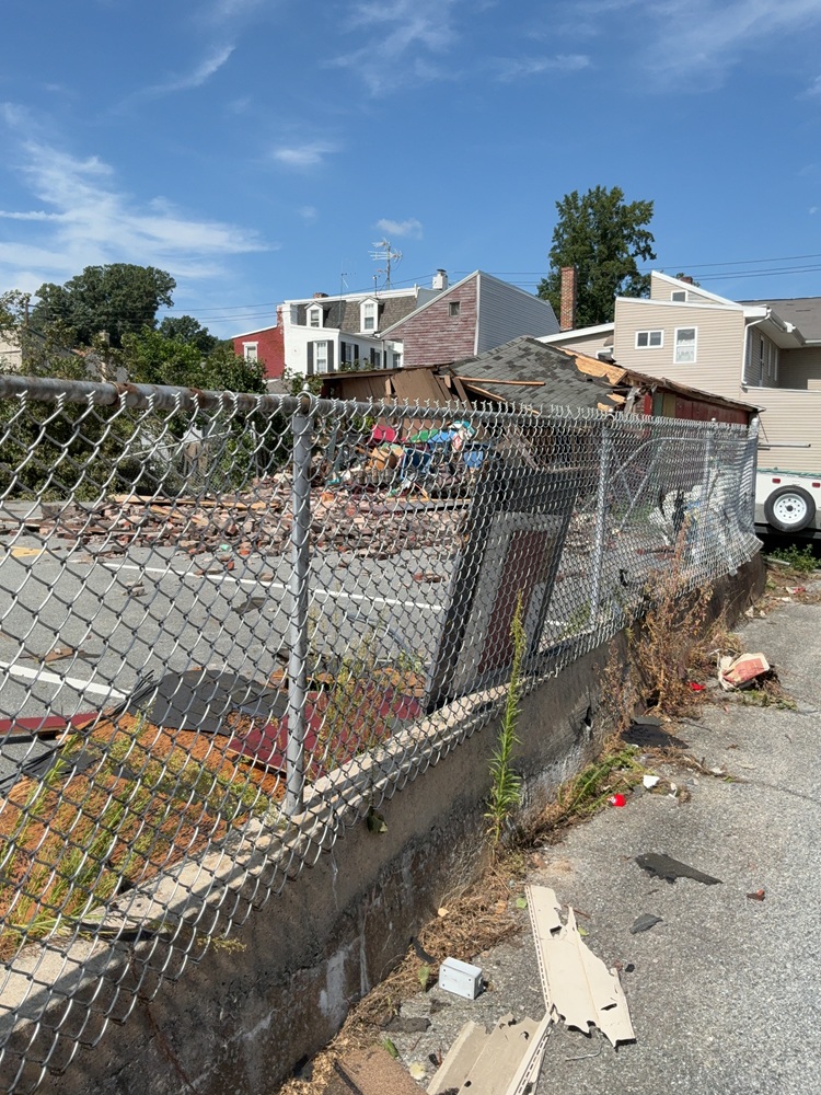
on the block where Walnut Street meets 4th Street. Damage was done
to an old firehouse where a section of the second story brick wall
was knocked down onto Avenue H and a neighboring store. The
firehouse roof and another adjacent roof were torn off and lying
nearby. The tornado continued southeast through town where a
couple small outbuildings were collapsed near Avenue K. Damage
continued down Malt Avenue with many tree limbs snapped and minor
damage to roofs. The tornado then crossed the Columbia Reading
Railway snapping some large trees along Manor Street and Furnace
Avenue. It continued into the wooded area south of town and across
Blue Lane where many trees were found uprooted and snapped.
Additional damage was discovered with numerous trees snapped or
uprooted along the western side of Richland Drive. The tornado
then continued over the ridge to the south of Richland Drive
before crossing over Shultz Road. The tornado then turned left
(toward the southeast) and left a path of convergent damage in a
corn field north of Charlestown Rd. Sporadic damage was observed
downstream of the tornado path on a farm, but it was not
continuous enough to definitely extend the tornado path further.

We would like to thank Lancaster County Emergency Management,
the Columbia Borough Police Department, and students from Millersville
University for their assistance in this damage survey.
..
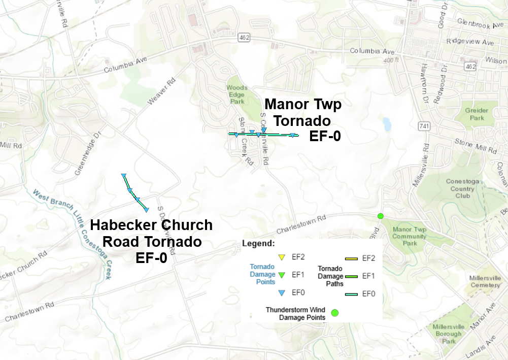
.Habecker Church Rd Tornado...

Rating: EF-0
Estimated Peak Wind: 65 mph
Path Length /statute/: 0.3 miles
Path Width /maximum/: 75 yards
Fatalities: 0
Injuries: 0

Start Date:             08/20/2026
Start Time:             04:37 PM EDT
Start Location:         2 ESE Mountville / Lancaster County / PA
Start Lat/Lon:          40.0271 / -76.402

End Date:               08/20/2026
End Time:               04:37 PM EDT
End Location:           2 ESE Mountville / Lancaster County / PA
End Lat/Lon:            40.0235 / -76.3989

Survey Summary:
A brief EF-0 tornado occurred at 4:37PM EDT on August 20, 2026.
The tornado began northwest of Habecker Church Rd and carved out a
narrow convergent swath of damage in several cornfields as it
moved south-southeast. The tornado began to occlude as it crossed
Habecker Church Rd, after which the path briefly widened and
became a bit less defined. Interestingly, there may have been a
second even more narrow vortex that developed to the east of the
parent vortex (to the left from a storm-relative standpoint) and
joined up with the main circulation near Habecker Church Rd. The
tornado likely lifted as it cycled and subsequently produced more
damage to the northeast as it a crossed a residential area.

We would like to thank students from Millersville University for
their assistance in this damage survey.
Public Information Statement
National Weather Service State College PA
542 PM EDT Tue Aug 25 2026

...NWS Damage Survey for 08/20/2026 Tornado Event...

..Manor Township Tornado...
Rating:                 EF0
Estimated Peak Wind:    85 mph
Path Length /statute/:  0.49 miles
Path Width /maximum/:   125 yards
Fatalities:             0
Injuries:               0

Start Date:             08/20/2026
Start Time:             04:38 PM EDT
Start Location:         2 E Mountville / Lancaster County / PA
Start Lat/Lon:          40.0314 / -76.3877

End Date:               08/20/2026
End Time:               04:40 PM EDT
End Location:           2 NW Millersville / Lancaster County / PA
End Lat/Lon:            40.0312 / -76.3784

Survey Summary:
An EF-0 tornado developed over Broadstone Street causing significant
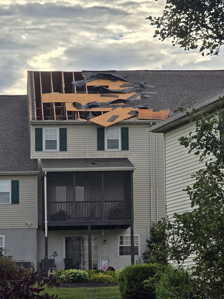
damage to trees and pulling gutters off of homes. The tornado
traveled east partially ripping a roof off of a townhouse as it
crossed Sutherland Road and uprooted additional trees in the
neighborhood. Finally it crossed South Centerville Road snapping
and uprooting numerous trees as it continued east before lifting
over a field.

We would like to thank Lancaster County Emergency Management and
students from Millersville University for their assistance in this
damage survey.

&&

EF Scale: The Enhanced Fujita Scale classifies tornadoes into the
following categories:

EF0.....65 to 85 mph
EF1.....86 to 110 mph
EF2.....111 to 135 mph
EF3.....136 to 165 mph
EF4.....166 to 200 mph
EF5.....>200 mph

NOTE: The information in this statement is preliminary and subject to
change pending final review of the event and publication in
NWS Storm Data.


$$




 ..
..

 Radar
Radar Current Weather
 Rivers & Lakes
 Satellite
 Forecast Maps
 Hour by Hour Forecast
 Tropical Weather
 Graphical Hazards
 Weather Hazards Briefing
 Fire Weather
 Text Forecasts and Statements
 Forecaster's Discussion
 Send Us a Report
 KCCX Local Radar (Hi-Res)
 Drought
 Winter
 Follow us on X
 Follow us on Facebook
 CTP RSS Feed