 2015 brought several memorable and historically important weather events to the Carolinas. Highlights include:
January: An arctic outbreak early in the month produced morning lows in the teens on January 8th, setting new daily record lows in Wilmington (16 degrees), Florence (14 degrees), and North Myrtle Beach (17 degrees). The heaviest rainfall in January was associated with strong low pressure that moved across the area January 23rd and 24th. Rainfall amounts over three inches were recorded along the coast along with wind gusts to 47 mph at North Myrtle Beach, 46 mph at North Topsail Beach, and 49 mph at Wrightsville Beach.
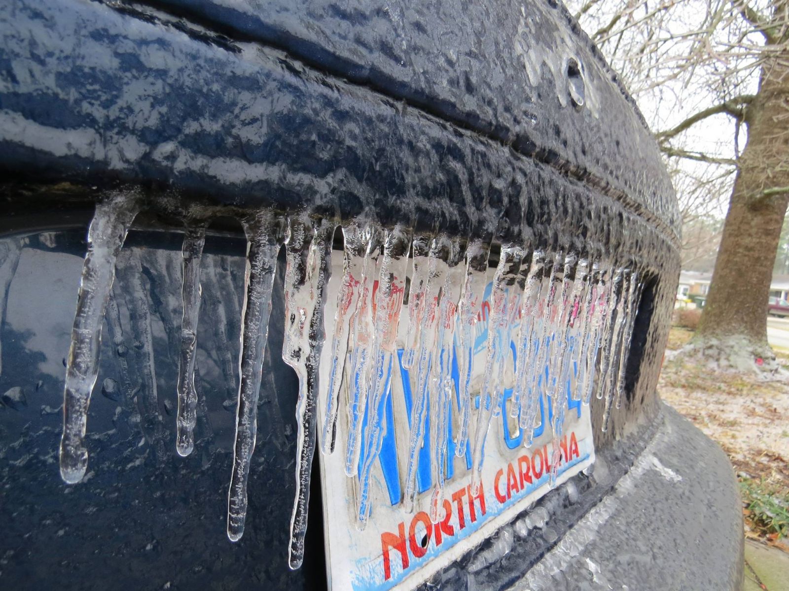
February: In Wilmington this was the fifth coldest February in recorded history; temperatures averaged a frigid 8.1 degrees below normal. Similarly cold departures for the month were observed in Florence (7.0 degrees below normal) and in North Myrtle Beach (7.1 degrees below normal). The culprit for this cold weather was a series of arctic outbreaks particularly during the second half of the month. An ice storm occurred on February 17th as moisture moved northward across a warm front across Florida and Georgia. Over a quarter inch of ice accumulated from Darlington and Bennettsville, SC through Lumberton, NC, with power outages affecting thousands of residents. Only small amounts of ice accumulated at the coast where temperatures only briefly dipped to the freezing mark.
 The worst of the cold temperatures occurred the morning of February 20th when lows fell to 13 degrees in Wilmington and Florence, and 15 in North Myrtle Beach. For Wilmington this was the coldest temperature observed since February 1996, a full 19 years earlier! Elizabethtown, NC reported a morning low of 9 degrees, the coldest in our area. This was an advective freeze meaning strong winds were blowing during the coldest temperatures. Wind chills dropped below zero in Wilmington and Southport where wind speeds were strongest. This wind also helped carry the cold air all the way down to the beaches with air temperatures on the fishing piers falling to exceptionally cold readings. Wrightsville Beach's Johnnie Mercer Pier and Myrtle Beach's Springmaid Pier reported 8 AM temperatures of 14 and 16 degrees, respectively, the coldest readings observed since those weather stations were installed.
 A second winter storm occurred on February 24th as low pressure moved northeastward along a stalled offshore front. Precipitation began as snow, but warming temperatures aloft transitioned the snow over to sleet and freezing rain. The heaviest snow fell across the northern portions of Robeson, Bladen and Pender counties in North Carolina where up to 1.4 inches of snow was reported from Watha. Freezing rain became quite heavy over coastal North Carolina during the afternoon and evening hours; ice accumulated up to four-tenths of an inch thick across Wilmington where bridges and elevated roads were closed due to dangerously icy conditions. A rare Ice Storm Warning was issued for the Cape Fear region of Southeastern North Carolina for what became the third-largest ice storm to affect Wilmington since 1948. A similar ice storm just one year earlier on February 11-12, 2014 also led to large ice accumulations across portions of the coastal Carolinas.
March: Compared to February, March was a relatively calm month weather-wise. Strong winds associated with showers along a cold front on March 5th produced damage to trees and power lines across the Florence and Darlington area of South Carolina. Gusts reached 56 mph at the Florence airport. The first 80-degree readings of the year occurred on March 11th. The 2015 growing season officially began after the final freeze of the spring on March 29th.
April: Severe thunderstorms developed north of Lumberton on April 9th, dropping 1.25" diameter hail in Parkton, NC. More severe storms on April 19th produced damaging winds across Darlington County, SC, with a brief EF-0 tornado touchdown in the Lamar community.
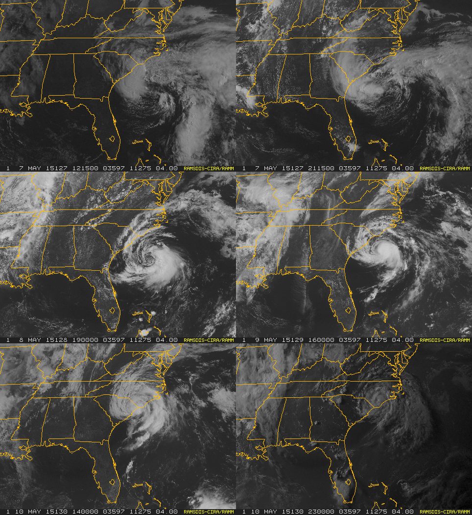
 May: Tropical Storm Ana, a rare out-of-season storm, developed from a cold upper level low pressure area north of the Bahamas. Specialists at the National Hurricane Center designated Ana as a subtropical storm on May 7th since it initially derived some of its strength from unusually cold temperatures aloft. By May 8th Ana's environment had warmed and the thunderstorm activity had become organized enough to define it as a fully tropical storm. Peak intensity occurred on May 9th when maximum sustained winds reached 60 mph.
Ana made landfall near Myrtle Beach, SC during the morning of May 10th and brought wind gusts of 50 to 60 mph to coastal Horry County, SC and Brunswick County, NC. These winds raised tidal departures of 1.4 to 2.3 feet above normal; however no coastal flooding was reported. Rainfall amounts over six inches occurred from Southport through Oak Island and Myrtle Beach, however this was largely beneficial rainfall during what is typically one of the drier periods of the year.
On May 21st an EF-1 tornado touched down near Bolton, NC, heavily damaging a mobile home. The tornado crossed U.S. highway 74/76 and tore a damage path five miles long through pine forests. Fortunately no fatalities or serious injuries occurred. An NWS storm survey found evidence of wind speeds up to 105 mph. Other severe thunderstorms in the same event caused damage to trees near White Lake, NC and to a barn near Delco, NC.
June: Severe thunderstorms on June 9th damaged trees in Darlington and Dovesville, SC, and produced flooding in Olanta, SC and Wilmington, NC. The first heat wave of the year developed in mid-June with highs reaching 101 degrees in Florence on four consecutive days June 15th through June 18th. At the Lumberton airport 100+ degree temperatures were recorded on six consecutive days June 13th through the 18th, including a scorching 104 degrees on both June 15th and 18th. This ties the longest string of consecutive 100 degree days in Lumberton observed since the year 2000. Even near the coast, Wilmington's high on June 15th reached 100 degrees, the first time that had happened in Wilmington since July 2012. Due in large part to this mid-month heat wave, temperatures for June averaged 3 to 5 degrees above normal across the eastern Carolinas, a significant departure for a summer month.
 July: Temperatures remained above normal in July with more 100+ degree temperatures occurring in Florence, SC on July 10th, 11th, and 21st. High humidity pushed heat indices above 110 degrees on July 21st, and an Excessive Heat Warning was issued for the inland Carolinas. On July 23rd severe thunderstorms developed during the afternoon hours producing numerous reports of damaging winds across the area. Most notable was a downburst which occurred in the heart of Wilmington's commercial district near Market Street and New Centre Drive. An NWS storm survey determined wind gusts reached 90 mph with damage observed to trees and buildings in the vicinity. A large air conditioning unit was thrown 30 yards from the top of a restaurant, damaging a nearby mini-storage building when it landed.
August: Severe thunderstorms affected the Florence area on August 5th, with damage to trees, powerlines, and even buildings at the Florence airport. The official observation from the Florence airport included a gust to 64 mph. This was also the hottest day of August with temperatures reaching 99 degrees in Lumberton, 98 in Florence, and 96 in Wilmington. On August 6th hail up to 1 inch in diameter fell near White Lake, NC, with flooding reported in nearby Elizabethtown. Cooler and drier weather developed during mid-August with low temperatures falling into the 60s for several mornings. Early morning severe storms affected Elizabethtown on August 26th. Wind gusts with these storms were estimated at 75 mph, destroying large pine trees and a farm silo. Later that afternoon another round of severe thunderstorms produced flooding, large hail and wind damage across interior Horry County, SC from Conway to Socastee.
 September: During the morning of September 9th a pair of waterspouts were reported off the coast of Topsail Beach, NC, and also in Winyah Bay near Georgetown, SC. Severe thunderstorms on September 10th knocked trees down across Williamsburg County, SC eastward to near Sampit in Georgetown County. Much cooler air spread into the Carolinas September 13th through the 16th. North Myrtle Beach set a record low of 56 degrees on September 15th, and temperatures fell to 49 degrees in Lumberton, the coolest readings seen there since the first week of May.
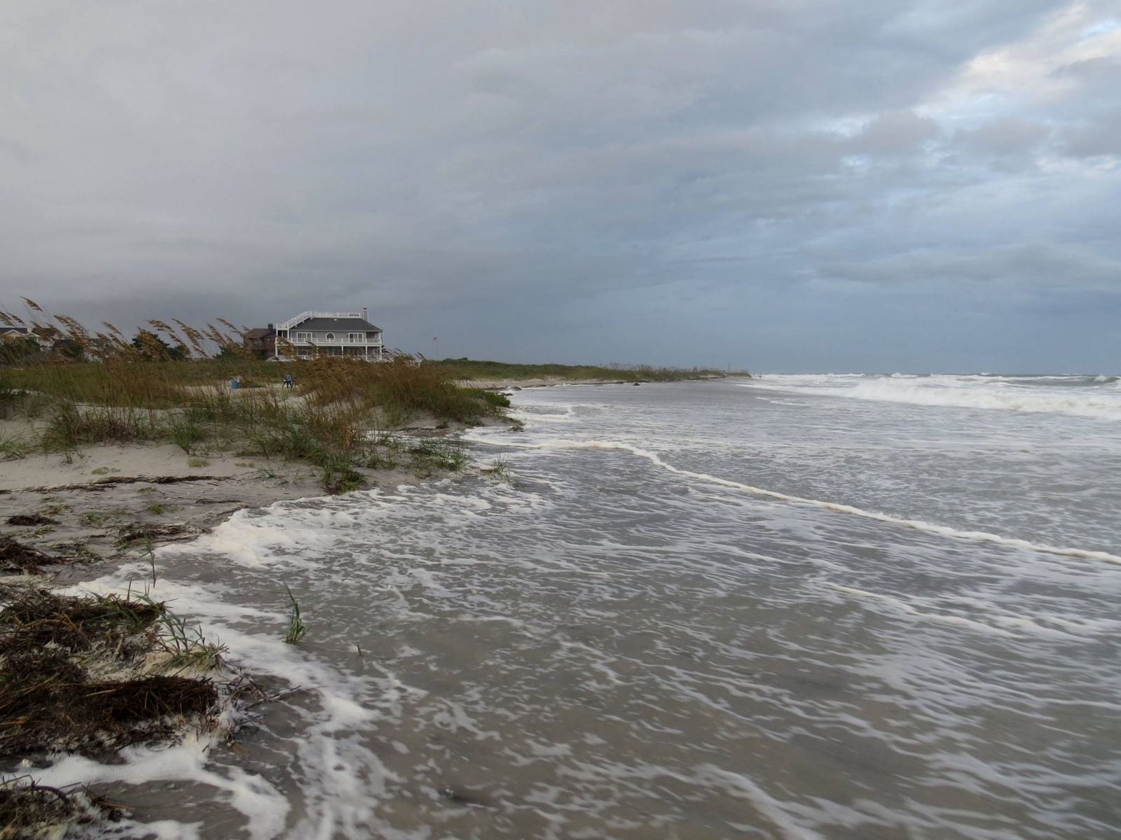
An interesting astronomical event (full moon and lunar eclipse) on September 27th was accompanied by moderate onshore winds. This produced unusually high tides and some of the worst coastal flooding in years. Water levels at Wrightsville Beach exceeded 7.1 feet above lower low mean water (MLLW) and at Myrtle Beach the ocean reached 8.25 feet MLLW. Significant erosion of dunes and beaches occurred and low-lying streets near the coast were flooded. Some of the worst damage occurred on Topsail Island, NC where ocean water entered garages and fences were washed away.
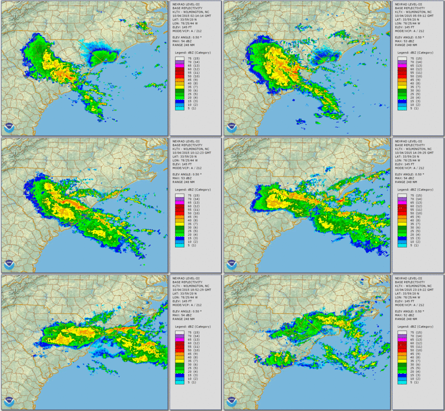
 October: Historic flooding occurred in early October as a persistent plume of tropical moisture dumped never-before-seen amounts of rain across eastern South Carolina. The heaviest rainfall occurred from October 2nd through 4th with anywhere from 2 to 10 inches of rain falling each day. Storm-total rainfall amounts were 20 to 24 inches near Georgetown and Kingstree, SC, with even higher totals in the Charleston/Mount Pleasant, SC area. According to an NWS Exceedance Probability Analysis on this event, heavy rainfall like this can be expected to occur less than once every thousand years across eastern South Carolina. Farther north rainfall amounts of 10 to 20 inches were reported from Florence to Myrtle Beach and across Brunswick County, NC into Wilmington. Numerous Flash Flood Warnings were issued as high water flooded roads, businesses and homes. Significant river flooding also developed in the days following the rain along most rivers in eastern South Carolina. The all-time record high stage was exceeded on the Black River by almost three feet at Kingstree, SC. Major flooding also occurred along the Waccamaw River near Conway with many dozens of homes flooded.
   |
Hurricane Joaquin, a deadly storm in its own right, was in the Bahamas during this time, but had no direct impacts to the United States mainland. Joaquin plus an upper level low over the Southeastern U.S. helped direct the plume of moisture into the Carolinas.
Flood waters were only slowly receding when a second wave of rainfall on October 10th created additional flooding. Rainfall amounts over 3 inches occurred in Myrtle Beach and Marion, SC. Normally these are totals insufficient to produce significant flooding; however the soil was still saturated from the historic floods earlier in the month. Roads were closed in Georgetown and Marion, SC due to this renewed flooding.
The remainder of October was thankfully dry. Unusually cool air October 18th through 20th allowed low temperatures to reach the upper 30s along the coast with readings as cold as 34 in Lumberton. Frost Advisories were issued for parts of North and South Carolina inland from the coast.
November: Wet weather redeveloped in early November as tropical moisture rode up and over a front stalled across Georgia. Rainfall amounts of 3 to 4 inches fell near Conway, SC and also across coastal Brunswick County, NC, on November 2nd and 3rd leading to minor flooding and some road closures. A small area of very heavy rain developed on November 4th near Mullins, SC with multiple road closures reported. Over seven inches of rain fell. The Old Nichols Highway bridge was washed out during this flooding.
 November's first widespread freeze occurred on November 24th behind a strong cold front. Temperatures dropped to 30 in Wilmington and Myrtle Beach, and 29 in Florence and Lumberton.
December: Temperatures during December averaged 12 to 14 degrees above normal due to a persistent and very strong ridge of high pressure that maintained a warm and humid flow of Caribbean air into the Carolinas. Except for a short-lived cooldown December 19th and 20th very mild weather persisted for the entire month. It was the warmest December in recorded history all across the Carolinas, beating the previous record by 1.5 degrees in Florence and by 4.0 degrees in Wilmington. With such a warm December coming on the heels of a warm November, nearshore ocean water temperatures were 10-15 degrees above normal during most of December. Kids were playing in the surf on Christmas Day with air temperatures near 80 and water temperatures in the mid 60s.
        *** Wilmington NC   2015 Climate Data - Preliminary ***

    Avg Hi/Dep Avg Lo/Dep  Avg T/Dep  Warmest   Coolest   Precip/Dep
JAN  56.9/+0.5  34.6/-1.0  45.8/-0.2  76/4th    16/8th    4.98/+1.22
FEB  52.1/-7.8  29.5/-8.4  40.8/-8.1  72/9th    13/20th   4.34/+0.72
MAR  66.6/+0.2  44.1/+0.3  55.3/+0.2  84/17th   25/7th    3.43/-0.78
APR  73.5/-0.7  54.2/+2.6  63.9/+1.0  83/8th    39/5th    2.16/-0.66
MAY  80.7/+0.0  61.2/+1.2  70.9/+0.5  92/19th   47/2nd    5.66/+1.17
JUN  89.9/+3.0  72.5/+3.8  81.2/+3.4 100/16th   63/8th    7.11/+1.93
JUL  91.4/+1.7  73.7/+1.1  82.5/+1.4  99/21st   65/25th   3.31/-4.17
AUG  87.5/-0.6  70.9/-0.4  79.2/-0.5  96/5th    66/29th   8.95/+1.54
SEP  84.6/+0.9  69.1/+3.5  76.8/+2.2  94/2nd    53/15th   5.47/-2.37
OCT  75.1/-0.6  56.0/+1.4  65.5/+0.3  84/3rd    38/19th  15.91/+12.02
NOV  70.8/+2.8  50.3/+4.9  60.6/+3.9  84/7th    30/24th   6.65/+3.36
DEC  70.9/+11.6 52.1/+14.3 61.5/+12.9 81/30th   28/20th   5.50/+1.88
---------------------------------------------------------------------
ANN  75.0/+0.9  55.7/+1.9  65.3/+1.3 100        13       73.47/+15.86

Number of days with Temperatures...
 90 degrees or higher: 48 (8 more than normal)
 32 degrees or lower:  42 (7 more than normal)

Heating degree days: 2087 (325 below normal)
Cooling degree days: 2349 (305 above normal)

Number of days with precipitation...
 0.01" or greater: 142 (7 more than normal)
 0.10" or greater: 98  (20 more than normal)
 0.50" or greater: 46  (11 more than normal)
 1.00" or greater: 22  (5 more than normal)

Snow or sleet fell on 3 days.
Measurable snow or sleet fell on 1 day totaling 0.3 inches.
Thunderstorms occurred on 58 days.

Average wind speed: 7.6 MPH
Maximum 2-minute wind speed: 39 MPH on February 2
Maximum 5-second wind gust:  62 MPH on June 18

        *** Florence SC   2015 Climate Data - Preliminary ***

    Avg Hi/Dep Avg Lo/Dep  Avg T/Dep  Warmest   Coolest   Precip/Dep
JAN  55.0/-0.3  34.4/-0.2  44.7/-0.2  76/4th    14/8th    2.43/-0.80
FEB  52.8/-6.8  30.5/-7.0  41.7/-6.8  72/9th    13/20th   4.50/+1.58
MAR  68.6/+1.0  46.1/+2.5  57.4/+1.8  86/11th   26/7th    3.40/+0.07
APR  76.4/+0.6  55.4/+4.7  65.9/+2.6  91/9th    40/5th    3.40/+0.78
MAY  85.7/+3.0  61.7/+2.3  73.7/+2.6  92/26th   48/2nd    1.29/-1.97
JUN  93.8/+5.4  71.7/+3.7  82.8/+4.6 101/26th   64/5th    3.50/-1.12
JUL  94.5/+3.5  73.2/+1.8  83.8/+2.6 102/10th   68/26th   3.40/-1.86
AUG  90.3/+0.9  71.3/+0.8  80.8/+0.9  98/5th    65/29th   5.92/+0.68
SEP  85.6/+1.4  68.2/+3.9  76.9/+2.7  94/4th    52/15th   2.99/-0.68
OCT  74.8/-0.7  54.9/+1.8  64.9/+0.6  84/16th   37/20th  14.71/+11.73
NOV  68.4/+1.3  49.5/+5.8  58.9/+3.5  79/7th    29/24th   4.40/+1.73
DEC  68.9/+11.1 50.1/+13.6 59.5/+12.4 82/29th   27/20th   7.09/+4.08
---------------------------------------------------------------------
ANN  76.2/+1.6  55.6/+2.8  65.9/+2.2 102        13       57.03/+14.12

Number of days with Temperatures...
 90 degrees or higher: 88 (32 more than normal)
 32 degrees or lower:  38 (2 fewer than normal)

Heating degree days: 2060 (464 below normal)
Cooling degree days: 2527 (465 above normal)

Number of days with precipitation...
 0.01" or greater: 130 (24 more than normal)
 0.10" or greater: 90  (20 more than normal)
 0.50" or greater: 38  (9 more than normal)
 1.00" or greater: 15  (3 more than normal)

Snow fell on 2 days.
Thunderstorms occurred on 43 days.

Average wind speed: 6.9 MPH
Maximum 2-minute wind speed: 47 MPH on August 5
Maximum 5-second wind gust: 64 MPH on August 5

   *** North Myrtle Beach SC   2015 Climate Data - Preliminary ***

    Avg Hi/Dep Avg Lo/Dep  Avg T/Dep  Warmest   Coolest   Precip/Dep
JAN  57.4/+2.3  37.1/+0.9  47.2/+1.5  71/4th    17/8th    4.12/+0.43
FEB  52.0/-5.4  31.3/-7.3  41.7/-6.3  67/12th   15/20th   3.07/-0.35
MAR  64.4/+0.3  46.3/+2.0  55.3/+1.1  84/17th   27/7th    2.43/-1.49
APR  72.3/+1.0  56.5/+4.6  64.4/+2.8  76/23rd   43/5th    3.64/+0.68
MAY  78.9/+0.3  63.4/+2.6  71.2/+1.5  88/21st   50/2nd    6.80/+3.39
JUN  87.8/+3.3  73.4/+4.1  80.6/+3.7  97/14th   66/8th    3.16/-1.48
JUL  89.1/+1.5  74.4/+1.3  81.7/+1.4  97/11th   69/26th   3.75/-2.15
AUG  86.5/+0.4  71.9/+0.2  79.2/+0.3  90/22nd   67/29th   5.79/-1.62
SEP  84.3/+0.9  69.4/+2.5  76.9/+1.8  90/20th   56/15th   5.33/-0.95
OCT  75.0/-0.1  57.5/+1.8  66.3/+0.9  82/13th   38/19th  18.73/+14.85
NOV  70.5/+3.9  51.9/+5.5  61.2/+4.7  81/7th    30/24th   4.89/+1.85
DEC  69.3/+10.8 52.3/+13.3 60.8/+12.0 77/28th   29/20th   3.12/-0.34
---------------------------------------------------------------------
ANN  74.0/+1.6  57.1/+2.5  65.5/+2.0  97        15       64.83/+12.82

Number of days with Temperatures...
 90 degrees or higher: 26 (10 more than normal)
 32 degrees or lower:  35 (5 more than normal)

Heating degree days: 1923 (585 below normal)
Cooling degree days: 2261 (358 above normal)

Number of days with precipitation...
 0.01" or greater: 128
 0.10" or greater: 84
 0.50" or greater: 32
 1.00" or greater: 18

Snow fell on 1 day.
Thunderstorms occurred on 56 days.

Average wind speed: 7.8 MPH
Maximum 2-minute wind speed: 38 MPH on May 9
Maximum 5-second wind gust: 50 MPH on May 9

   *** Lumberton NC    2015 Climate Data - Preliminary ***

    Avg Hi/Dep Avg Lo/Dep  Avg T/Dep  Warmest   Coolest   Precip/Dep
JAN  53.6/-0.1  33.4/+0.2  43.5/+0.1  75/4th    15/8th    4.69/+1.72
FEB  51.2/-6.8  29.9/-5.7  40.5/-6.3  72/9th    13/20th   4.77/+1.87
MAR  66.6/+0.3  44.3/+2.3  55.5/+1.4  84/11th   25/7th    3.48/+0.15
APR  75.2/+0.7  53.0/+4.0  64.1/+2.4  87/9th    33/5th    2.59/-0.23
MAY  85.3/+3.2  59.1/+1.5  72.2/+2.4  92/31st   45/3rd    1.93/-1.12
JUN  94.6/+6.1  71.1/+3.7  82.8/+4.8 104/18th   63/8th    6.24/+1.90
JUL  93.7/+2.7  72.5/+1.2  83.1/+2.0  99/21st   64/26th   1.30/-4.18
AUG  91.1/+2.8  70.1/+0.4  80.6/+1.6  99/6th    63/29th   3.98/-1.52
SEP  86.3/+2.6  67.3/+5.0  76.8/+3.8  95/4th    49/15th   2.45/-2.35
OCT  75.5/+0.0  53.3/+2.0  64.4/+1.0  85/23rd   34/20th   6.42/+3.85
NOV  68.7/+1.5  48.4/+7.0  58.6/+4.3  79/7th    29/24th   5.10/+2.23
DEC  69.5/+12.7 50.1/+14.5 59.8/+13.6 80/29th   28/20th   6.89/+4.00
---------------------------------------------------------------------
ANN  75.9/+2.0  54.4/+3.0  65.2/+2.6 104        13       49.84/+6.32

Number of days with Temperatures...
 90 degrees or higher: 92 (41 more than normal)
 32 degrees or lower:  38 (11 fewer than normal)

Heating degree days: 2211 (550 below normal)
Cooling degree days: 2441 (531 above normal)

Number of days with precipitation...
 0.01" or greater: 125
 0.10" or greater: 91
 0.50" or greater: 35
 1.00" or greater: 11

Snow fell on 3 days.
Thunderstorms occurred on 49 days.

Average wind speed: 6.1 MPH
Maximum 2-minute wind speed: 37 MPH on March 5
Maximum 5-second wind gust: 46 MPH on March 5

2015 Radar-derived Rainfall Maps

Doppler radar estimated precipitation totals for 2015. The hot pink color along the North & South Carolina coast indicates totals over 70 inches.

Doppler radar estimated departure from normal rainfall for 2015. The hot pink color across parts of South Carolina indicates annual rainfall totals were 20+ inches above normal.

Doppler radar estimated departure from normal rainfall for 2015. The blue color across parts of South Carolina indicates annual rainfall totals were 150 percent of normal.
Research and Page Author: Tim Armstrong
Page Created: January 1, 2016
Last Updated: January 1, 2016