Damaging wind gusts occurred across portions of eastern North and South Carolina during the morning of March 12, 2022 along and ahead of a strong cold front. The highest winds occurred along the coast and offshore where an anemometer atop Frying Pan Tower recorded a gust to 97 mph at 10:45 am EST.
|
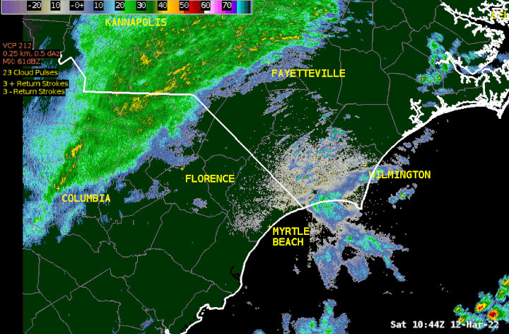
Radar loop from Saturday, March 12, 2022. The cold front and squall line swept across the area during the morning hours. |
A weather balloon released and tracked by the Newport/Morehead City NWS office at 7 am Saturday morning recorded wind speeds of 67 mph just 2,000 feet above ground level. These strong winds aloft mixed down to to the surface, knocking down numerous trees and causing power outages across the Grand Strand and Cape Fear areas between 8 and 9 am.
A tornado watch was in effect Saturday morning for coastal portions of North and South Carolina. No reports of tornado touchdowns were received, but the squall line along the cold front brought another burst of damaging winds along with thunderstorms and briefly heavy rain.
|
The Brunswick County Sheriff's Office shared this picture of a tree down on U.S. Highway 74/76 shortly before 10 AM on Saturday, and also reported Saw Mill Rd and Old Lanville Rd were closed due to downed power lines. |
|
Since deciduous trees had not yet leafed out, overall wind damage was less than would have occurred during summer thunderstorms. The relatively brief duration of the strong winds also helped prevent more damage.
The following table contains many of the peak wind gust reports gathered by the National Weather Service on Saturday.
|
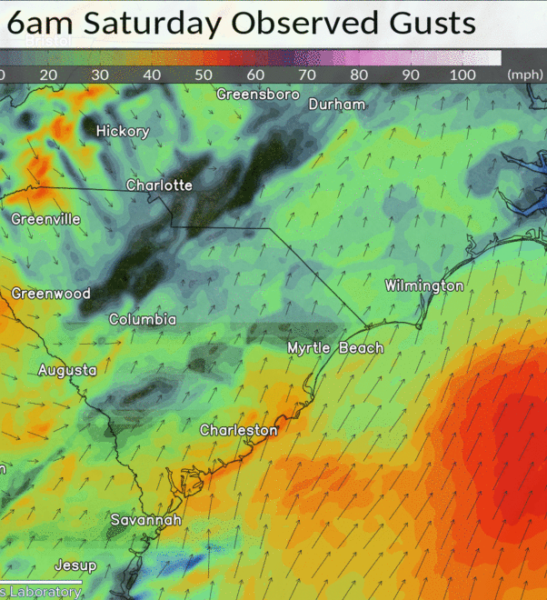
Hourly Wind Gusts analyzed by the Real Time Mesoscale Analysis (RTMA) system. This loop runs from 6:00 AM until Noon EST on Saturday March 12, 2022.
A more detailed list of local peak wind gust observations is available here: https://mesonet.agron.iastate.edu/wx/afos/p.php?pil=PNSILM&e=202203121742 |
Cold air surged in behind the front and led to falling temperatures Saturday afternoon. A hard freeze occurred Saturday night into Sunday morning with temperatures measured in the upper 20s at the beaches and as cold as 21 degrees in Hartsville and 19 degrees in Kingstree, SC.
This was actually the second time this year where widespread strong winds have occurred across the eastern Carolinas. On January 3 a line of strong to severe thunderstorms developed along a cold front and produced numerous 50 to 60 mph wind gusts across the area.
Research & Page Author: Tim Armstrong
Last Updated: March 13, 2022


 Coastal Flood