|
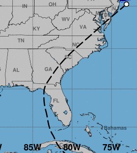
The track of Tropical Storm Elsa across South and North Carolina on July 8, 2021 |
Tropical Storm Elsa brought gusty winds and locally heavy rainfall to the eastern portions of South and North Carolina on July 8, 2021. Wind gusts over 50 mph occurred on the beaches, with over four inches of rain reported from a few locations in coastal South Carolina.
Elsa developed from an early-season tropical wave in the Atlantic on July 1. The new tropical storm moved westward at speeds up to 29 mph, exceptionally fast for a tropical cyclone still in the deep tropics. Elsa strengthened into a category 1 hurricane while approaching Barbados on July 2, but then weakened the following day before passing north of Jamaica. Strong winds on Barbados caused property damage to homes and businesses. Turning northwest, Elsa moved across Cuba on July 5 causing flash flooding and mudslides. The storm reached the eastern Gulf of America on July 6. Briefly strengthening back to a hurricane while located west of Tampa late on July 6, Elsa weakened before its landfall on the Florida Panhandle on the morning of July 7 with maximum sustained winds near 65 mph.
Elsa maintained tropical storm strength as it moved northeastward across Georgia and the Carolinas on July 8 due to favorable upper-level winds and the proximity of the warm ocean. Multiple tornado touchdowns occurred from Florida north through New Jersey on July 7-8, however none occurred in northeastern South Carolina or southeastern North Carolina.
When Elsa strengthened to a tropical storm in the Atlantic on July 1, it immediately set a record as the earliest in the year the fifth named storm had developed, beating the record established back in 2020 when Tropical Storm Edouard formed on July 6.
Elsa was actually the third tropical storm to strike the Carolinas this season; on June 21 tropical depression Claudette regained tropical storm status while located across inland northeastern North Carolina. And on June 28 Tropical Storm Danny struck the South Carolina coast with 40 mph winds, bringing up to six inches of rain but otherwise little impact.
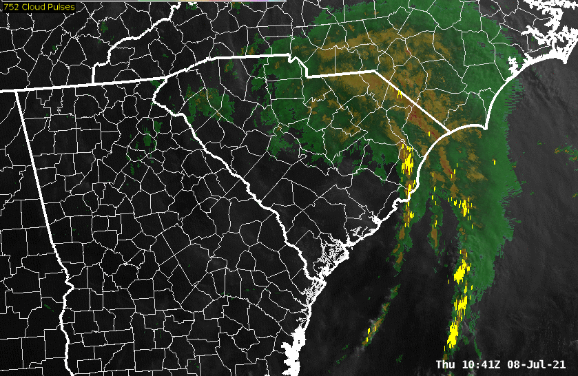
Visible satellite and radar composite of Tropical Storm Elsa moving across South and North Carolina. This loop runs from 6:41 am until 2:56 pm EDT on July 8, 2021. Lightning strikes are indicated in yellow.
Wind
Despite the center of Elsa tracking rather far inland across South and North Carolina, the strongest winds occurred across the coastal waters and beaches where gusts over 50 mph were reported from a number of airports, buoys, and automated weather stations. A few trees were blown down by the wind across Darlington, Florence, and Marion counties in South Carolina. Additional wind damage was reported in Horry County, SC where a number of trees were blown down along Ocean Boulevard during the morning of July 8. In the Arrowhead community a large tree fell and damaged a fence. Later in the day trees fell across power lines at Kings Highway and 72nd Avenue North knocking the lines down onto an occupied vehicle. No injuries were reported. At the height of the storm 14,000 customers were without electricity across Horry County.
|
URMA-analyzed wind gusts during Tropical Storm Elsa's passage across South and North Carolina on July 8, 2021 |
| Location | Sustained Wind | Peak Gust |
| mph | mph | |
| Sunset Beach Nearshore Buoy | 40 | 58 |
| Frying Pan Tower | 49 | 58 |
| Sunset Beach-Intracoastal Waterway, NC | 43 | 56 |
| Oak Island, NC | 49 | 55 |
| Wrightsville Beach-Johnnie Mercer Pier, NC | 47 | 54 |
| Myrtle Beach International Airport, SC | 41 | 54 |
| Southport-Cape Fear River Pilots, NC | 54 | |
| Federal Point, NC | 48 | 54 |
| Kure Beach Pier, NC | 45 | 53 |
| Futch Beach, SC | 41 | 53 |
| Sunset Beach-38th Street, NC | 36 | 52 |
| North Myrtle Beach Grand Strand Airport, SC | 37 | 50 |
| Holden Beach-Starfish Dr., NC | 50 | |
| Figure Eight Island, NC | 41 | 50 |
| Murrells Inlet, SC | 41 | 49 |
| Hampstead-2 miles E, NC | 42 | 47 |
| Wrightsvile Beach Nearshore Buoy | 36 | 47 |
| North Myrtle Beach Fire Station #4-Barefoot, SC | 46 | |
| DeBordieu Colony, SC | 46 | |
| N. Myrtle Beach Fire Station #2-Cherry Grove, SC | 45 | |
| Florence Regional Airport, SC | 26 | 45 |
| Wilmington International Airport, NC | 35 | 44 |
| Wrightsville Beach Offshore Buoy | 34 | 45 |
| Frying Pan Shoals Buoy | 36 | 45 |
| Lockwoods Folly Inlet, NC | 37 | 44 |
| North Myrtle Beach Fire Station #3-Windy Hill, SC | 44 | |
| Sunny Point RAWS, NC | 43 | |
| Bald Head Island, NC | 30 | 42 |
| Georgetown, SC | 31 | 42 |
| Wilmington-Kings Grant, NC | 40 | |
| N. Myrtle Beach Fire Station #1-Ocean Drive, SC | 38 | |
| Georgetown Airport, SC | 22 | 36 |
| Myrtle Beach-Lake Arrowhead, SC | 18 | 32 |
| Kingstree Airport, SC | 18 | 31 |
Rainfall
Elsa's rain fell mainly during the morning and early afternoon hours, tapering off to lighter showers and sprinkles later in the day. Most locations picked up between 1 and 4 inches, with a few higher totals across Georgetown and Horry counties in coastal South Carolina. Some minor street flooding was reported along 51st Ave. North in Cherry Grove, SC during the morning of July 8.
Coastal North Carolina saw the smallest rainfall totals with barely half an inch recorded in Wilmington.
|
Locally Measured Rainfall Totals (inches)
|
Other Impacts
Although Elsa's strongest winds occurred near high tide for coastal South Carolina, water levels remained well below coastal flood criteria at the Myrtle Beach tide gauge. Water levels peaked at 1 to 2 feet above the predicted astronomical tide along the coast, but no flooding or significant beach erosion occurred.
| Highest Level | Highest Level | Time | Max Surge (feet) | Time | |
| feet MLLW | feet MHHW | EDT | departure from astro. tide | EDT | |
| Winyah Bay-Oyster Landing North Inlet | 5.13 | 0.03 | 8:30 PM | +1.26 | 11:36 AM |
| Myrtle Beach | 5.90 | 0.30 | 6:54 AM | +1.65 | 6:54 AM |
| Wrightsville Beach | 4.64 | 0.16 | 7:06 PM | +1.46 | 11:10 AM |
| Wilmington-Cape Fear River Downtown | 5.53 | 0.85 | 10:00 PM | +2.38 | 2:54 PM |
Additional Information
NWS Wilmington NC: Post-Storm Report on Elsa (technical)
NOAA NESDIS: Tropical Storm Elsa Sets Records for 2021 Atlantic Hurricane Season
SCNow: Elsa soaks Pee Dee on its way from the Gulf to the Atlantic
WMBF News: Heavy winds from Elsa topple palm trees on Ocean Blvd.
NWS Storm Prediction Center: Tornado Reports from July 7 and July 8
National Hurricane Center: Archive of Elsa forecasts and discussions
Research and Page Author: Tim Armstrong
Last Updated: July 18, 2021


 Coastal Flood