One of the strongest El Niños on record is expected to bring climate impacts across the Carolinas this fall season. NOAA forecasters are predicting a below normal hurricane season due to increased wind shear across the tropical Atlantic. Above normal rainfall may develop later this fall across most of North and South Carolina - a consequence of additional Pacific moisture brought our way by the global circulation changes caused by El Niño.
El Niño and the Atlantic Hurricane Season
El Niño, a natural periodic warming of ocean waters across the tropical Pacific Ocean, causes shifts in weather patterns across large portions of the planet. The currently-developing El Niño is expected to become extraordinary in strength; CPC states there is almost a 70 percent chance of this becoming the strongest El Niño on record.
What are El Niño and La Niña and how do they affect the weather?
|
Late August 2026 global sea surface temperature anomalies. The tropical east Pacific Ocean is exceptionally warm, in places over 5°C (9°F) hotter than normal along the equator west of Colombia and Ecuador. |
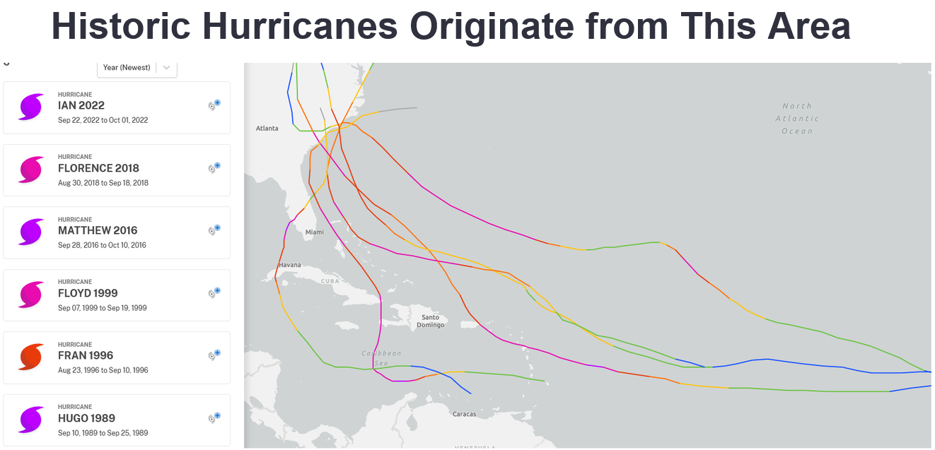
During the fall El Niño typically leads to a reduction in the number and strength of Atlantic tropical storms and hurricanes. This is mainly due El Niño's enhancement in vertical wind shear across the Main Development Region of the tropical Atlantic Ocean, the birthplace of many of our notable and historic hurricanes.
Wind shear, a change in the speed and direction of winds with height, causes thunderstorm clusters to tilt as they grow upward. This tilt reduces the amount of heat that can accumulate aloft over the core of a developing tropical cyclone. Without this reservoir of low-density warm air aloft, it's not possible for a tropical cyclone to maintain low pressure at its center and the storm will not strengthen.
|
|
Tropical cyclones that move into a region experiencing strong wind shear tend to weaken or even dissipate as they lose the organized thunderstorms that sustains low pressure at the center of the storm. El Niño's suppression of Atlantic tropical cyclones can occur even with above-normal ocean water temperatures as we currently see across most of the Atlantic, Caribbean, and Gulf this year.
|
The Official NOAA Seasonal Hurricane Outlook shows a 75 percent chance of a below-normal Atlantic season |
While wind shear across the tropical Atlantic should lead to fewer named storms overall this year, it doesn't guarantee a tropical cyclone won't affect the Carolinas. Tropical storms and hurricanes can still form outside of the tropics where wind shear isn't as strongly affected by El Niño.
|
Many of our strongest local hurricane strikes from have been storms that form within the Atlantic Main Development Region (MDR), a region experiencing very high wind shear this Hurricane Season |
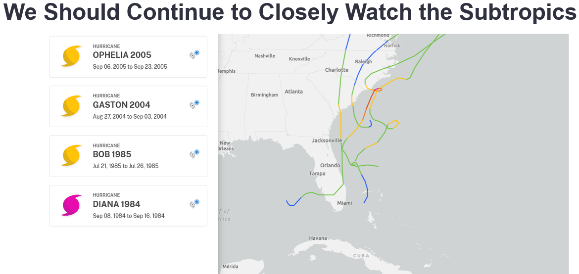
Some storms form much closer to home where this season's wind shear is not expected to be affected as much by El Niño. This is the region we may need to watch particularly closely. |
These locally-born tropical systems have brought significant impacts to the Carolinas in the past: storms like 2005's Hurricane Ophelia, 2004's Hurricane Gaston, 1985's Hurricane Bob, and 1984's Hurricane Diana all developed outside of the tropics and brought local impacts on eastern North and South Carolina. Even Potential Tropical Cyclone Eight in 2024, while never a full-fledged tropical storm, formed just off the Carolina coast and produced terrible flash flooding with 15 to 20 inches of rain measured across portions of Brunswick and New Hanover counties in North Carolina.
Preparedness for hurricanes starts now. NOAA maintains a curated list of resources for help get you and your family ready: https://www.noaa.gov/hurricane-prep
Drought and Rainfall
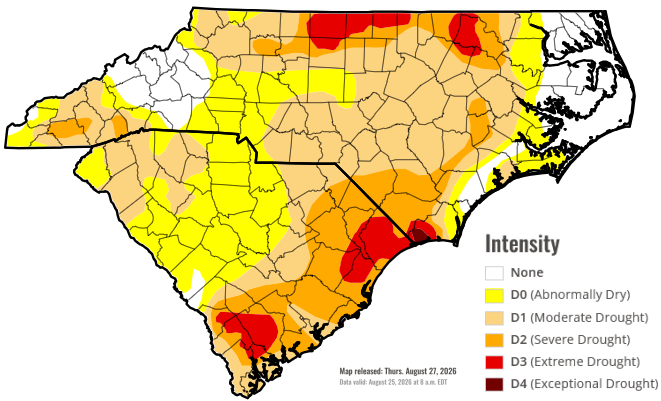
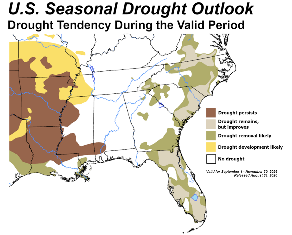
Moderate to locally severe drought continues across many portions of eastern North and South Carolina. Although rainfall totals in the past month have been above normal in some locations, accumulated rainfall deficits over the past six months are still over 11 inches in North Myrtle Beach, SC.
|
US Drought Monitor valid Thursday, August 27. Moderate to severe drought still covers large sections of eastern North and South Carolina |
Fall in the Carolinas is associated with tremendous rainfall variability from year to year. This is mainly due to the uneven distribution of Atlantic tropical storms and hurricanes. In fall seasons without a landfalling tropical cyclone, it's tough for seasonal rainfall totals to reach the long term average regardless of whether we have La Niña, neutral, or El Niño conditions in place. These quiet fall seasons sometimes see September through November rainfall totals less than 10 inches and can be accompanied by drought conditions.
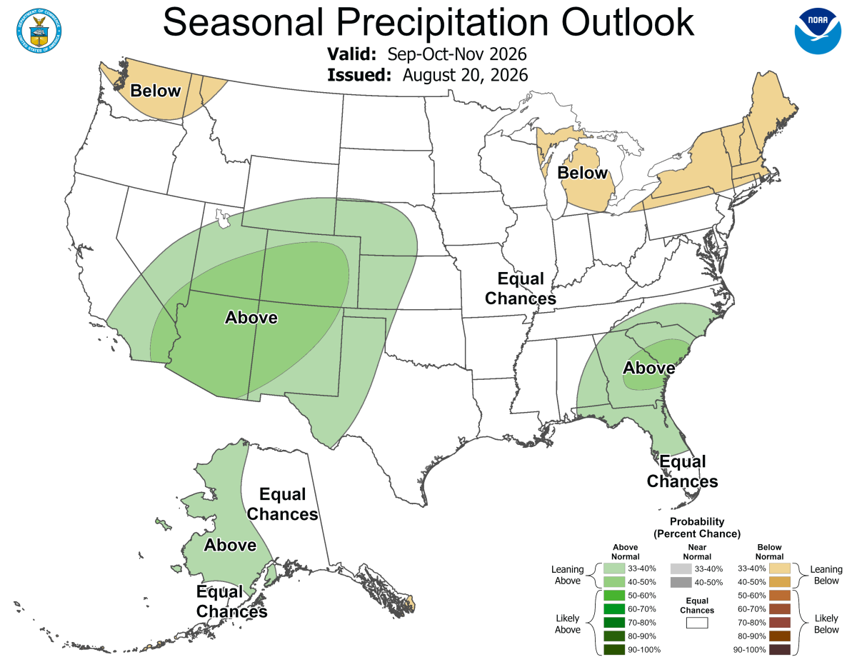
The outlook from the Climate Prediction Center is for an increased potential for above normal rainfall this fall season. This is due to the expectation that El Niño will enhance the amount of Pacific moisture transported northward by the subtropical jet stream. Once we move into the cooler half of fall, periodic cold fronts and low pressure systems may be able to drop heavier-than-normal rainfall because of a strong connection back to Pacific Ocean moisture.
|
The Fall Precipitation Outlook from the NWS Climate Prediction Center shows an increased potential for above normal precipitation totals across most of eastern North and South Carolina |
The Seasonal Drought Outlook from the NWS Climate Prediction Center shows the drought should improve or possibly end this Fall across portions of eastern North and South Carolina. |
Temperatures
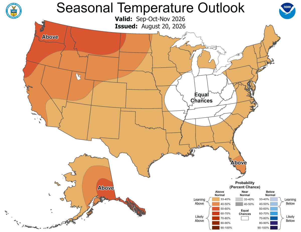
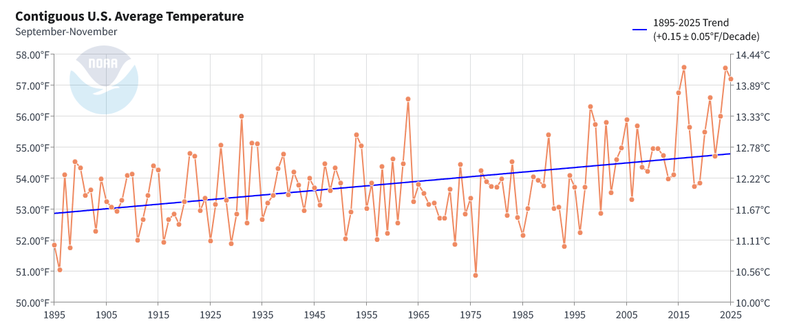
The Climate Prediction Center outlook for an increased chance of above-normal temperatures this fall is largely based on multi-decadal trends toward warmer temperatures as a consequence of ongoing climate change.
|
NWS Climate Prediction Center seasonal temperature outlook shows an increased potential for above-normal temperatures across the eastern Carolinas this fall. |
NOAA NCEI graphic showing United States Fall average temperature from 1894 through the present. |
Climate Change is primarily caused by increasing atmospheric concentration of greenhouse gases from the extraction and burning of fossil fuels. Carbon dioxide and methane gas trap heat within the atmosphere that would otherwise radiate out into space. Average temperatures across the Carolinas, and the planet as a whole, are increasing.
Climate.gov: How have global temperatures changed?
NC Climate Office: Climate Change in North Carolina
Last winter the "El Niño Southern Oscillation" (ENSO) was in its cold phase known as La Niña. La Niña transitioned to neutral ENSO conditions during the spring, then to El Niño this summer. El Niño is not associated with significant impacts on temperatures across the Carolinas during the fall.
|
Change in risk of warm or cold temperature extremes during the fall months (September - November) during El Niño years. The eastern Carolinas see no significant impact. Research and graphics from NOAA PSD. |
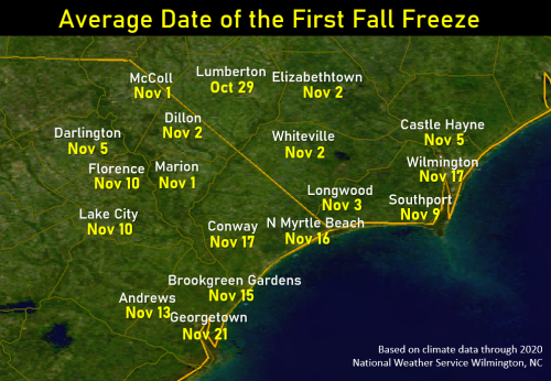
The first freezing temperatures of the fall usually reach the eastern Carolinas before Thanksgiving Day. The average date of the first freeze ranges from October 29 in Lumberton, NC to November 21 in Georgetown, SC, but there is considerable year-to-year variability. This first freeze thankfully brings an end to mosquitoes, but unfortunately also to summer gardens as tomatoes, peppers, and other annual plants are killed.
In Wilmington, the season's first freeze has occurred as early as October 16 (in 1878) and as late as December 29 (in 1918). But in Southport, NC first freeze dates have been even more extreme: the 1945 growing season didn't end in Southport until temperatures finally fell to freezing on January 10, 1946! That growing season of 327 days is the longest on record for any local city.
|
|
|
Coastal Flooding Potential
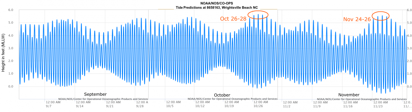
There are two periods this fall when astronomical tides will be large enough where minor coastal flooding could occur without a storm system in the area. "Sunny day" flooding could easily occur on the following dates:
|
Predicted astronomical tides at Wrightsville Beach, NC for fall 2026 |
Tides will be particularly high during October's Full Moon (October 26) and November's Full Moon (November 24.) These full moons are within 1-3 days of the Moon's perigee -- its closest approach in its orbit to Earth when the Moon's tidal influence is strongest.
Landfalling tropical storms or hurricanes can produce significant coastal flooding regardless of the astronomical tides. And as we move into November, non-tropical storms called Nor'easters can produce strong winds and coastal flooding too.
|
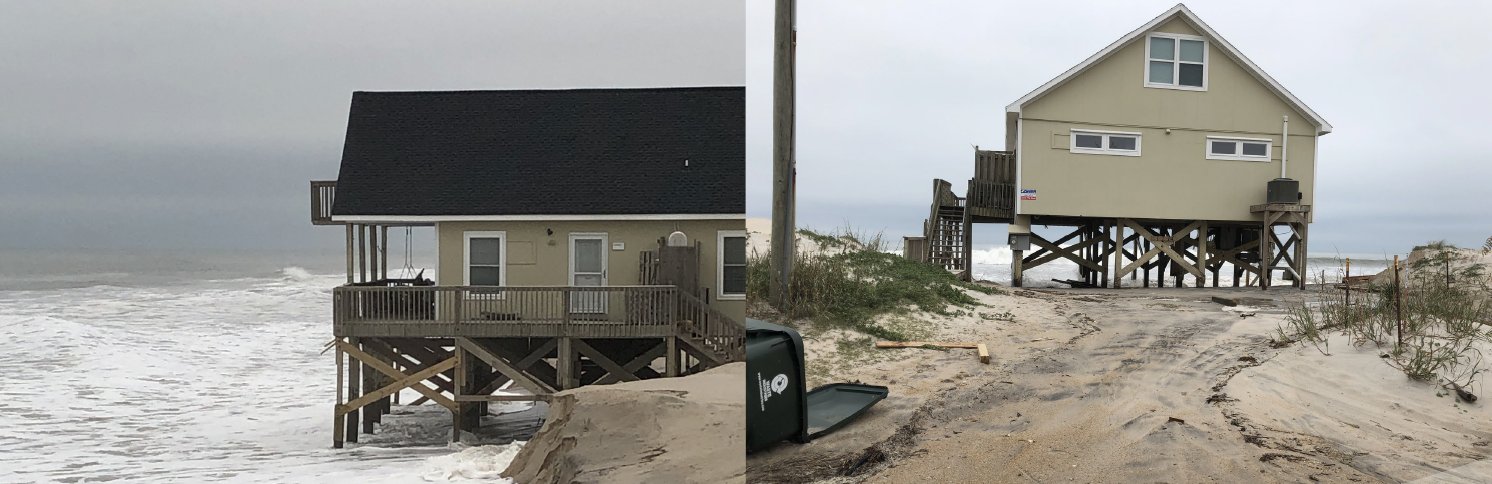
A significant coastal storm in November 2019 produced coastal flooding and beach erosion. This photo provided by Surf City Emergency Management shows surf eroding sand from beneath a home on the beach. |
Additional Reading
NOAA Hurricane Season Outlook August 2026 Update: https://www.cpc.ncep.noaa.gov/products/outlooks/hurricane.shtml
CPC: ENSO Recent Evolution, Current Status and Predictions
National Ocean Service High Tide Flooding Outlook: https://tidesandcurrents.noaa.gov/high-tide-flooding/monthly-outlook.html
NWS Wilmington Tropics Main Page: https://www.weather.gov/ilm/tropical
NWS Wilmington Significant Local Events Archive: https://www.weather.gov/ilm/SignificantLocalEvents
Daily Climate Normals and Records for Wilmington, Florence, North Myrtle Beach, and Lumberton.
Research and Author: Tim Armstrong
Last Updated: September 3, 2026






 Radar
 Current Weather
 Rivers & Lakes
 Satellite
 Forecast Maps
 Hour by Hour Forecast
 Tropical Weather
 Graphical Hazards
 Weather Hazard Briefing
 Forecaster's Discussion
 Text Bulletins
 Climate
 Skywarn
 NOAA Weather Radio
 Sunrise/Sunset
 Marine Forecasts
 Beach & Surf
 Coastal Flood
 Follow us on X
 Follow us on Facebook
 Follow us on YouTube
 ILM RSS Feed