Pacific and Gulf moisture arriving from the southwest rode up and over shallow arctic air at the surface across the eastern Carolinas on January 25, 2026, leading to a thin glaze of freezing rain and some sleet. The largest accumulations of freezing rain, up to three-tenths of an inch in thickness on elevated objects, was reported from Lumberton and Red Springs in Robeson County, NC. Lesser amounts of ice were reported from most other locations.
|
Radar loop from the morning of January 25 to the morning of January 26, 2026 showing precipitation falling across the Carolinas. Precipitation was primarily light freezing rain until heavier precipitation arrived the night of January 25-26. Inland temperatures finally warmed above freezing during this final band of rain. |
|
Impacts were generally minor due to relatively warm ground temperatures that limited accumulations on solid surfaces. In Wilmington, a portion of Martin Luther King Jr. Parkway was closed for several hours during the morning of January 25 due to ice accumulation on bridges. Florence County Emergency Management warned local residents of at least three icy bridges. Traffic accidents due to ice were reported from Florence and Hartsville, SC.
According to a map shared by WPDE news, some storm-related power outages occurred across portions of Bladen, Robeson, Marlboro, and Darlington counties.
Some schools were closed Monday due to lingering ice on roadways. Air travel was difficult due to many closed airports across the Southeast and Mid Atlantic states from this large storm system.
|
From Linnie Johnson in St. Pauls, NC |
From Tiffany Smith in Supply, NC |
|
From Mariel Chanson in Wallace, NC |
Icicles formed on cars at the NWS office in Wilmington, NC |
Why Freezing Rain and Not Snow?
Although temperatures near the surface were certainty cold enough to support snow, temperatures aloft were much too warm. During this event, maps of temperatures at 925, 850, and 700 millibars (standard upper air levels often used by meteorologists) showed a deep layer of well-above freezing temperatures was present. Snowflakes that had formed in colder regions of the atmosphere melted as they fell through this warm air, but refroze into freezing rain (or some sleet) within the shallow cold air near the surface. A few lightning strikes were reported near Bennettsville and Georgetown, SC.
|
700 mb temperatures, wind, and moisture at 10 pm EST January 25, 2026. Analyzed temperatures at this level near 10,000 feet aloft were near +4°C or 39°F. |
 850 mb temperatures, wind, and moisture at 10 pm EST January 25, 2026. Analyzed temperatures at this level near 5,000 feet aloft were +3°C to +7°C or 39°F to 45°F. 850 mb temperatures, wind, and moisture at 10 pm EST January 25, 2026. Analyzed temperatures at this level near 5,000 feet aloft were +3°C to +7°C or 39°F to 45°F. |
|
925 mb temperatures, wind, and moisture at 10 pm EST January 25, 2026. Analyzed temperatures at this level near 2500 feet aloft were +13°C to +17°C or 55°F to 63°F. |
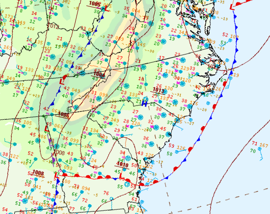
The surface weather map showed temperatures ranged from below freezing near and west of Interstate 95 to the upper 30s and lower 40s along the Carolina coast. |
Research and Page Author: Tim Armstrong
Last Updated: January 27, 2026


 Coastal Flood