HOME
FORECAST
Local
Graphical
Aviation
Marine
Rivers and Lakes
Hurricanes
Severe Weather
Fire Weather
Sunrise/Sunset
Long Range Forecasts
Climate Prediction
Space Weather
PAST WEATHER
Past Weather
Astronomical Data
Certified Weather Data
SAFETY
INFORMATION
Wireless Emergency Alerts
Weather-Ready Nation
Brochures
Cooperative Observers
Daily Briefing
Damage/Fatality/Injury Statistics
Forecast Models
GIS Data Portal
NOAA Weather Radio
Publications
SKYWARN Storm Spotters
StormReady
TsunamiReady
Service Change Notices
EDUCATION
NEWS
SEARCH
Search For
NWS
All NOAA
ABOUT
About NWS
Organization
For NWS Employees
National Centers
Careers
Contact Us
Glossary
Social Media
NWS Transformation
Local forecast by
"City, St" or ZIP code
Sorry, the location you searched for was not found. Please try another search.
Multiple locations were found. Please select one of the following:
Location Help
News Headlines
Summer Climate Outlook covers Drought, Hurricane Season, and El Niño...
Heat Forecast/Safety Info
Hurricane Season is Here...Get Hurricane Ready!
National Hurricane Center Product/Service Changes for 2026 Hurricane Season
Customize Your
Weather.gov
Enter Your City, ST or ZIP Code
Remember Me
LOADING...
NWS Wilmington, NC
Weather Forecast Office
NWS Wilmington NC River Monitor
Weather.gov
>
NWS Wilmington, NC
> NWS Wilmington NC River Monitor
Current Hazards
Briefing Page
River Flooding
Space
Winter
Local Outlook
Drought
Thunderstorms
Hurricanes
Submit Storm Report
Hazard Criteria
Current Conditions
Observations (Map)
Air Quality
Satellite
Rainfall
Observations (List)
Marine Obs (Map)
Marine Obs (List)
Radar
Local KLTX Enhanced Radar
Local KLTX Standard Radar (low bandwidth)
Regional Standard Radar (low bandwidth)
National Standard Radar (low bandwidth)
Forecasts
Forecasters' Discussion
Aviation
Map View
Hourly View
Tropical
Marine/Ocean
Beach/Surf
Coastal Flooding
Fire
Heat
Winter
Mobile
Enhanced Graphics
Product Listing
Rivers and Lakes
Current & Past Streamflow
Ensemble River Guidance
River Forecast Centers
River Observations (Map)
River Forecasts (Map)
Climate and Past Weather
CoCoRaHS
24 Hour Summary
Snowfall Records
Past Observed Weather
Past Rainfall
Drought Outlook
Climate Prediction
Climate Plots
Significant Event Archive
Weather History Calendar
Severe Storm Climatology
Tropical Cyclone Reports
Local Programs
About Our Office
Education/Outreach
Storm/Tsunami Ready
Skywarn Storm Spotters
NOAA Weather Radio
Science/Technology
CoCoRaHS Observers
Cooperative Observers
Student Volunteers
No Flood
Near Flood
Minor Flood
Moderate Flood
Major Flood
River Conditions at: 4:30 PM 05/24/2024
Location
Flood
Stage (ft.)
Observed
(ft.)
24-Hr
Change
Crest (ft.)
Forecast for 8AM
Sat.
Sun.
Mon.
Tue.
Cape Fear River
William O Huske L&D
42
36.05
-0.7
-
-
-
-
-
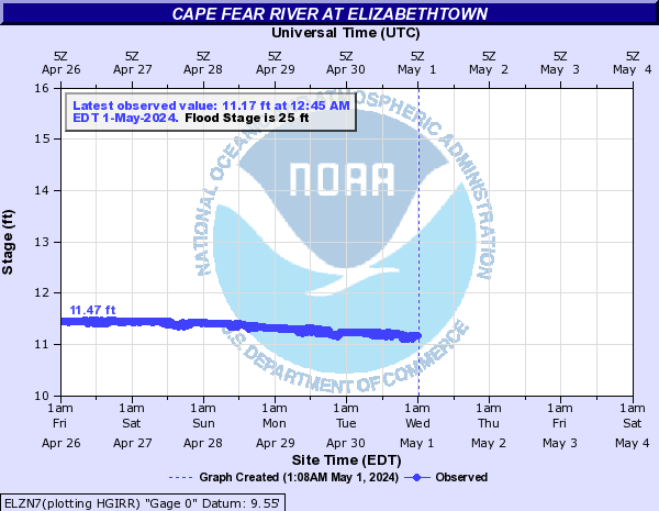
Elizabethtown
25
14.25
-1.5
-
-
-
-
-
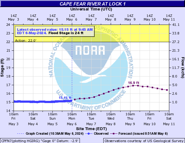
Lock and Dam 1 near Kelly
24
17.91
-0.9
17.91
17.3
16.8
16.3
15.9
Northeast Cape Fear River
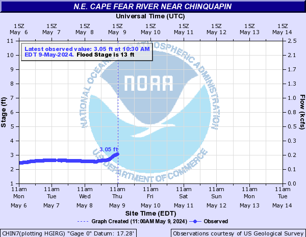
Chinquapin
13
3.43
-0.4
-
-
-
-
-
Burgaw
10
3.01
-0.3
-
-
-
-
-
Black River NC
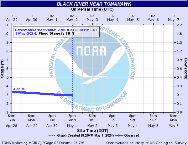
Tomahawk
18
3.96
-0.2
-
-
-
-
-
Currie
-
2.41
-0.1
-
-
-
-
-
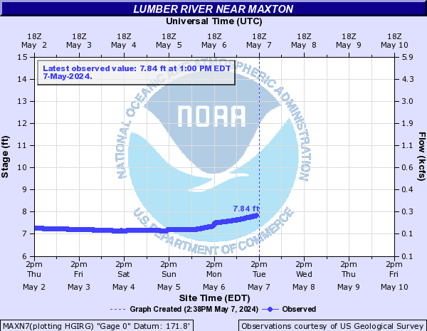
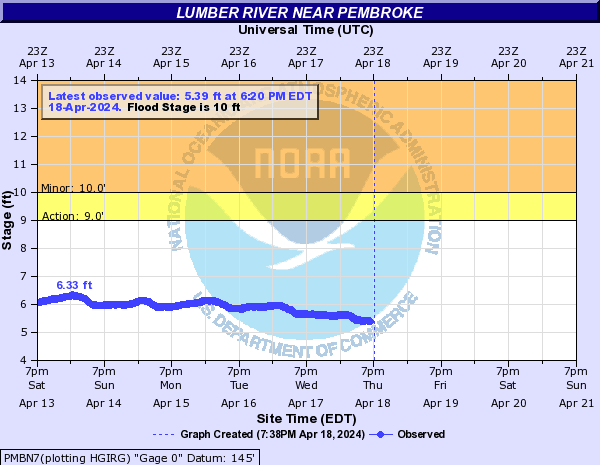
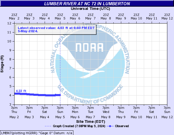
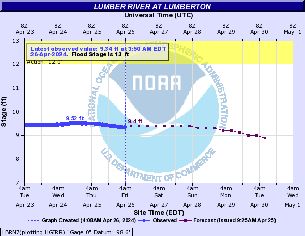
Lumber River
Maxton
-
9.10
-0.2
-
-
-
-
-
Pembroke
10
7.31
-0.1
-
-
-
-
-
NC Route 72
-
7.11
+0.1
-
-
-
-
-
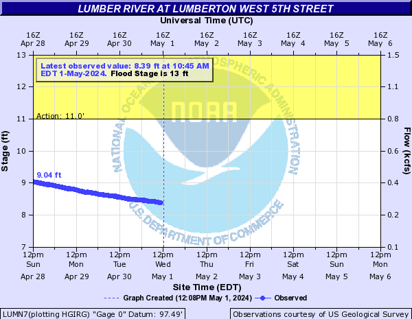
Lumberton
13
11.31
-
11.4
11.3
11.1
10.8
10.5
Lumberton West 5th Street
13
10.79
+0.1
-
-
-
-
-
Boardman
-
5.46
0.0
-
-
-
-
-
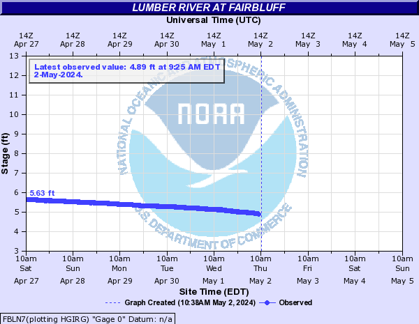
Fairbluff
-
7.29
-0.3
-
-
-
-
-
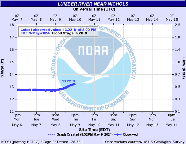
Nichols
20
16.17
-0.3
-
-
-
-
-
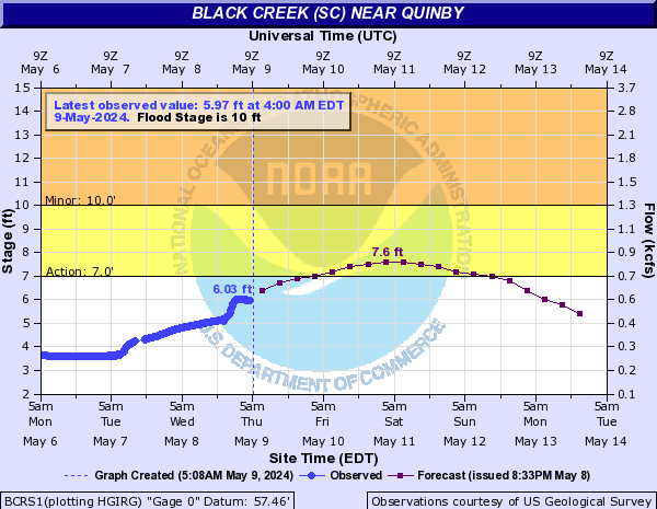
Black Creek
Hartsville 5 West
-
3.55
+0.1
-
-
-
-
-
Quinby
10
3.90
-0.8
4.9
-
-
-
-
Great Pee Dee River
Rockingham 6 West
15
3.49
+0.4
-
-
-
-
-
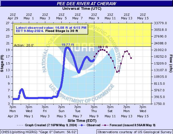
Cheraw
30
7.68
+1.0
9.8
9.2
9.7
5.0
3.9
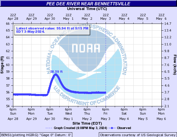
Bennettsville 10 Southwest
-
60.14
+0.9
-
-
-
-
-
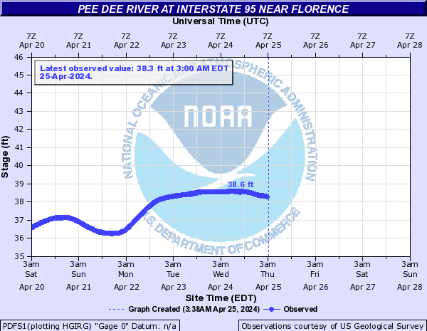
Pee Dee River at Interstate 95
-
43.35
-2.3
-
-
-
-
-
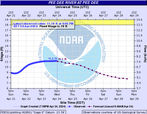
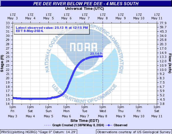
Pee Dee
19
17.57
-1.8
17.7
17.1
16.0
15.3
12.5
Pee Dee 4 South
-
25.73
-1.3
-
-
-
-
-
US Route 378
-
24.10
-0.3
-
-
-
-
-
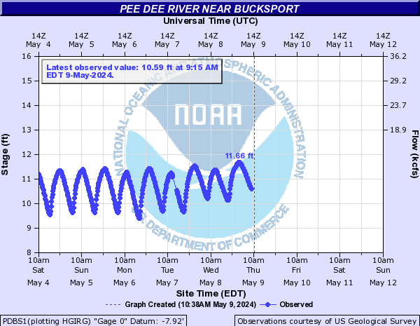
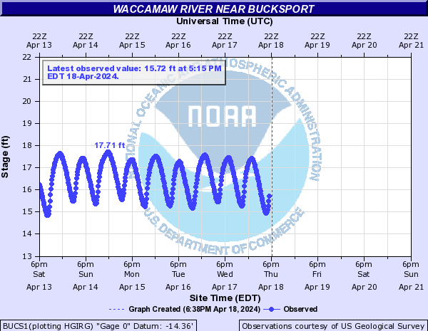
Bucksport
-
13.73
+0.2
-
-
-
-
-
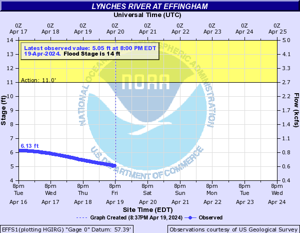
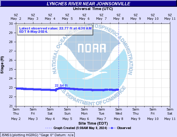
Lynches River
Effingham
14
7.26
-0.6
-
-
-
-
-
Johnsonville
-
23.93
-0.1
-
-
-
-
-
Little Pee Dee River
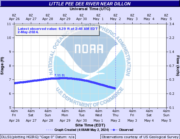
Dillon
-
7.42
-0.1
-
-
-
-
-
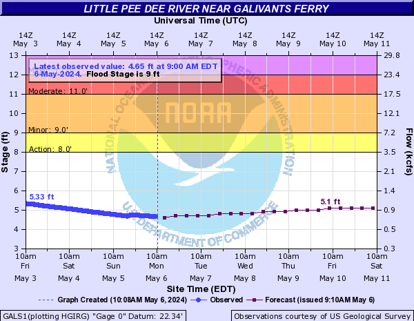
Galivants Ferry
9
7.18
0.0
7.2
7.1
7.1
7.0
7.0
Black River SC
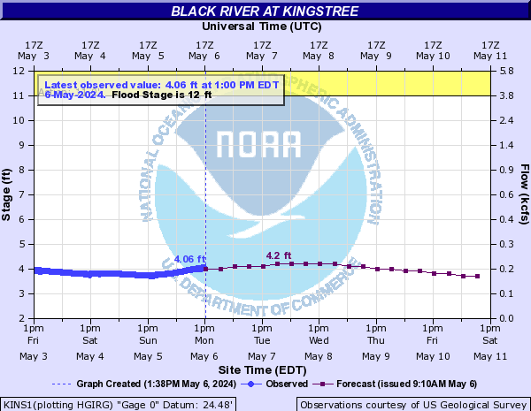
Kingstree
12
4.68
-0.3
4.7
4.7
4.7
4.6
4.4
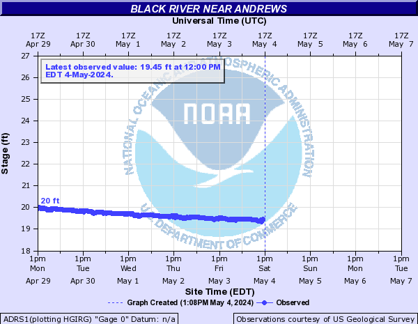
Andrews
-
19.79
-0.1
-
-
-
-
-
Dunbar
-
15.67
-0.4
-
-
-
-
-
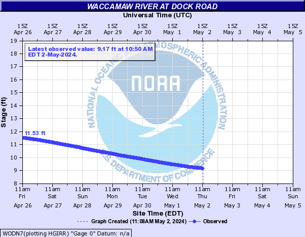
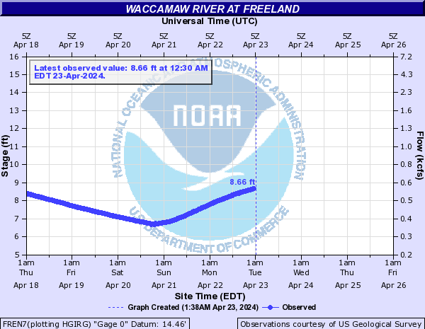
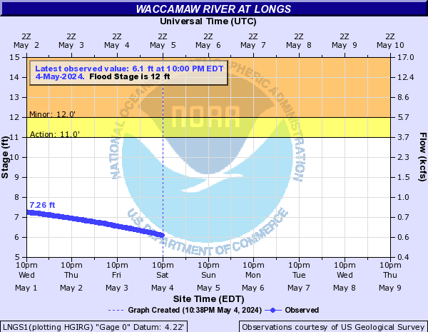
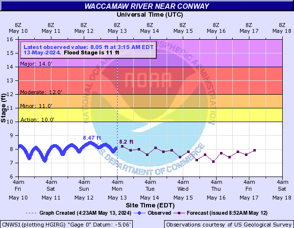
Waccamaw River
Dock Road
-
9.92
+0.4
-
-
-
-
-
Freeland
-
5.67
0.0
-
-
-
-
-
Longs
12
4.83
-0.3
-
-
-
-
-
SC Highway 22
-
11.52
-0.2
-
-
-
-
-
Above Conway
-
2.47
-0.2
-
-
-
-
-
Conway
11
8.43
-0.1
8.6
8.6
8.5
8.5
8.5
Bucksport
-
17.35
-0.2
-
-
-
-
-
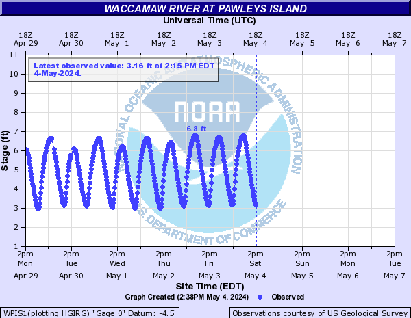
Pawleys Island
-
4.31
-0.3
-
-
-
-
-
Radar
Current Weather
Rivers & Lakes
Satellite
Forecast Maps
Hour by Hour Forecast
Tropical Weather
Graphical Hazards
Weather Hazard Briefing
Forecaster's Discussion
Text Bulletins
Climate
Skywarn
NOAA Weather Radio
Sunrise/Sunset
Marine Forecasts
Beach & Surf
Coastal Flood
Follow us on X
Follow us on Facebook
Follow us on YouTube
ILM RSS Feed


 Coastal Flood