|
Fast Facts
|
|
Lakeshore Flooding
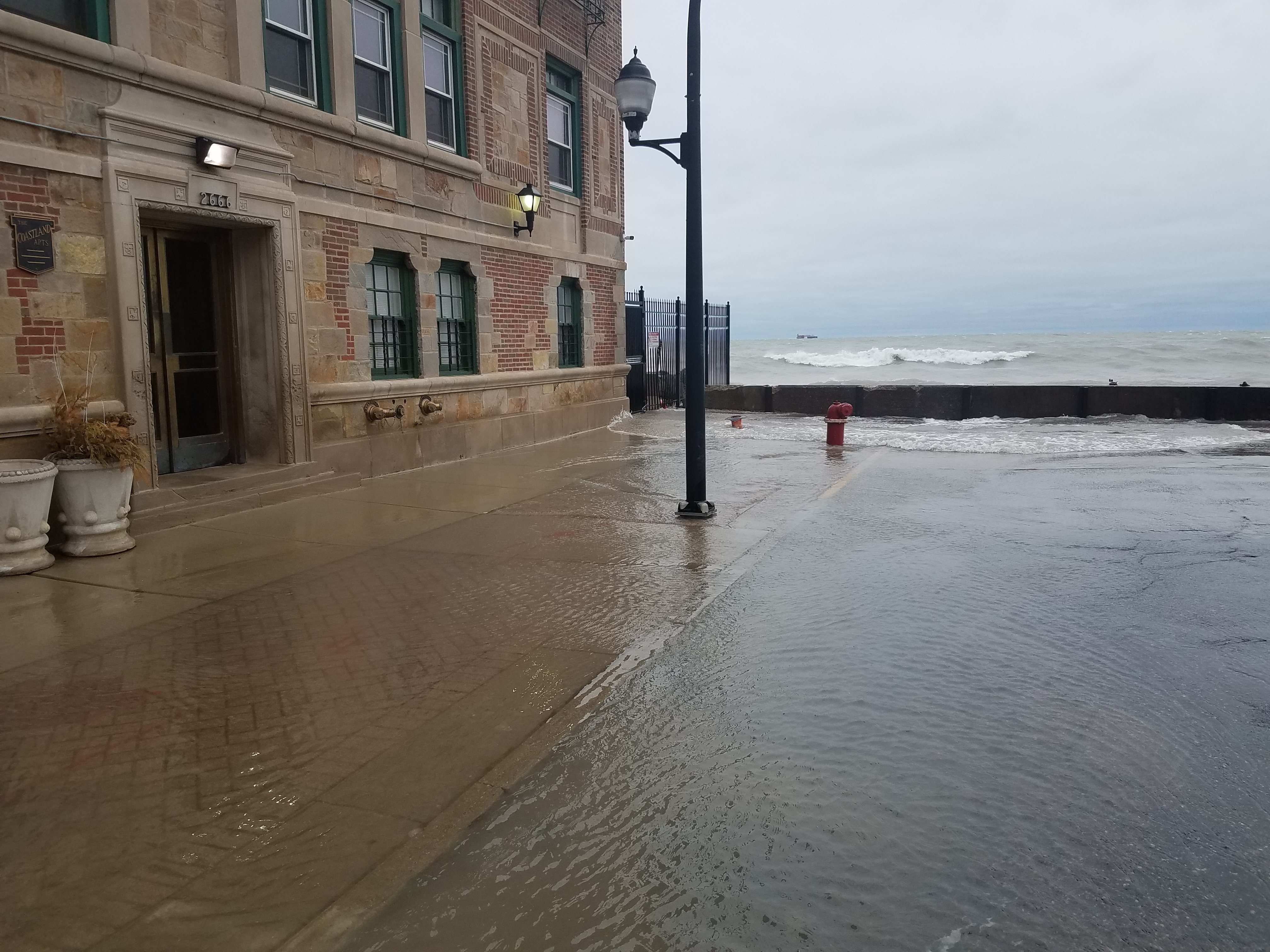
The below photos are courtesy of the Chicago Office of Emergency Management and Communications (OEMC).
 |
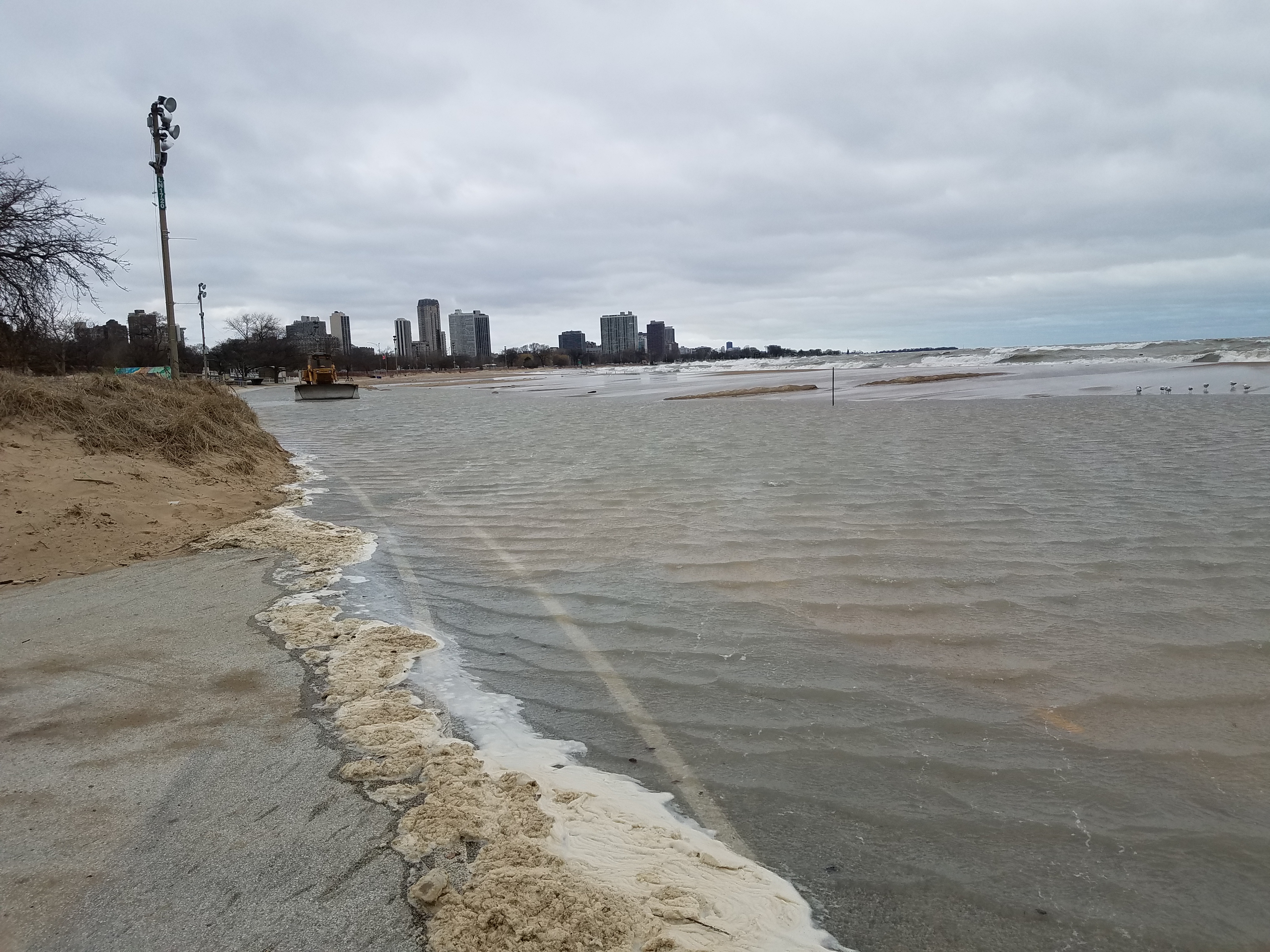 |
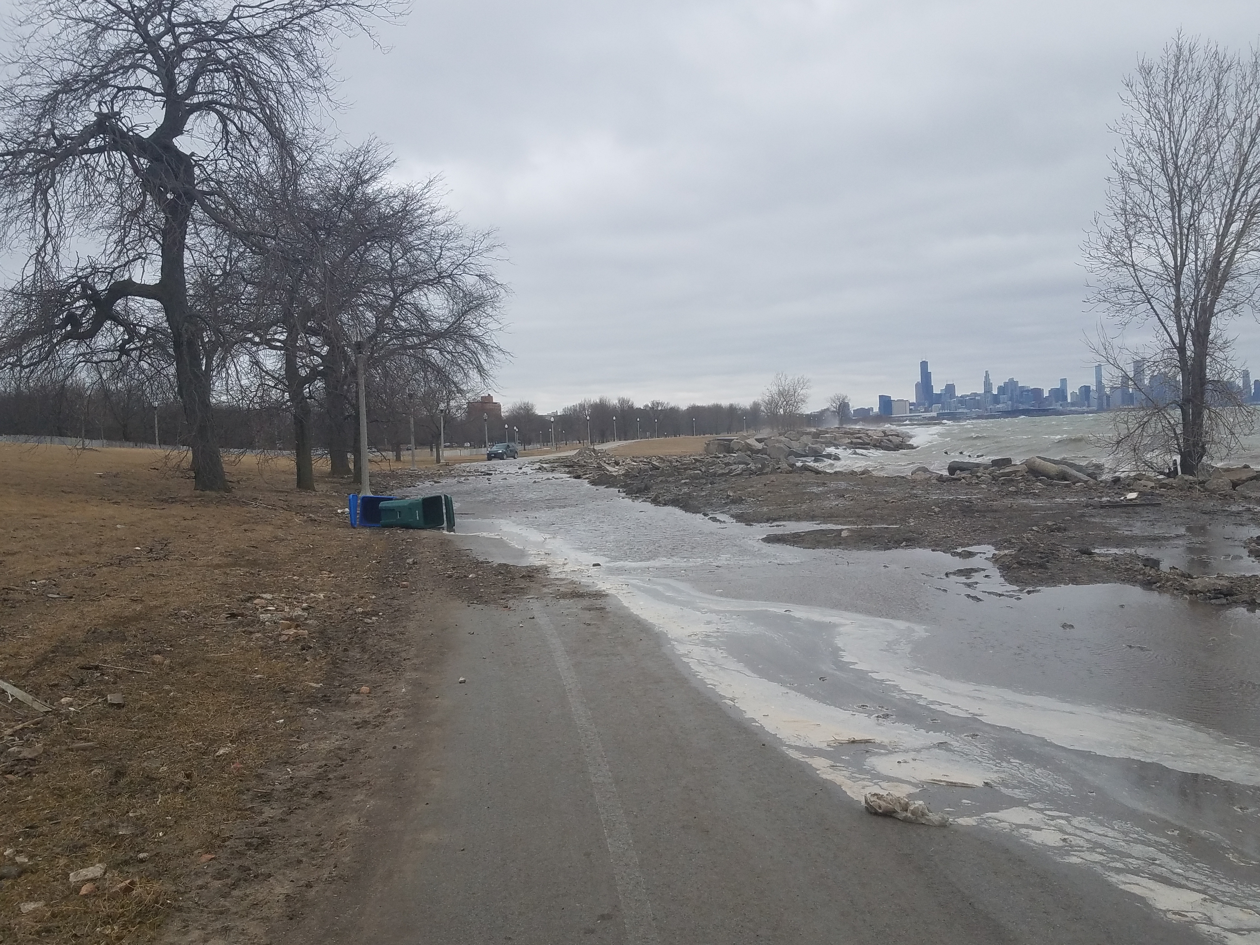
| Chicago, IL Bike Path near 47th St. | North Avenue Beach in Chicago, IL. |
 |
 |
| Chicago, IL near South Shore and 73rd | Chicago, IL near South Shore and 73rd |
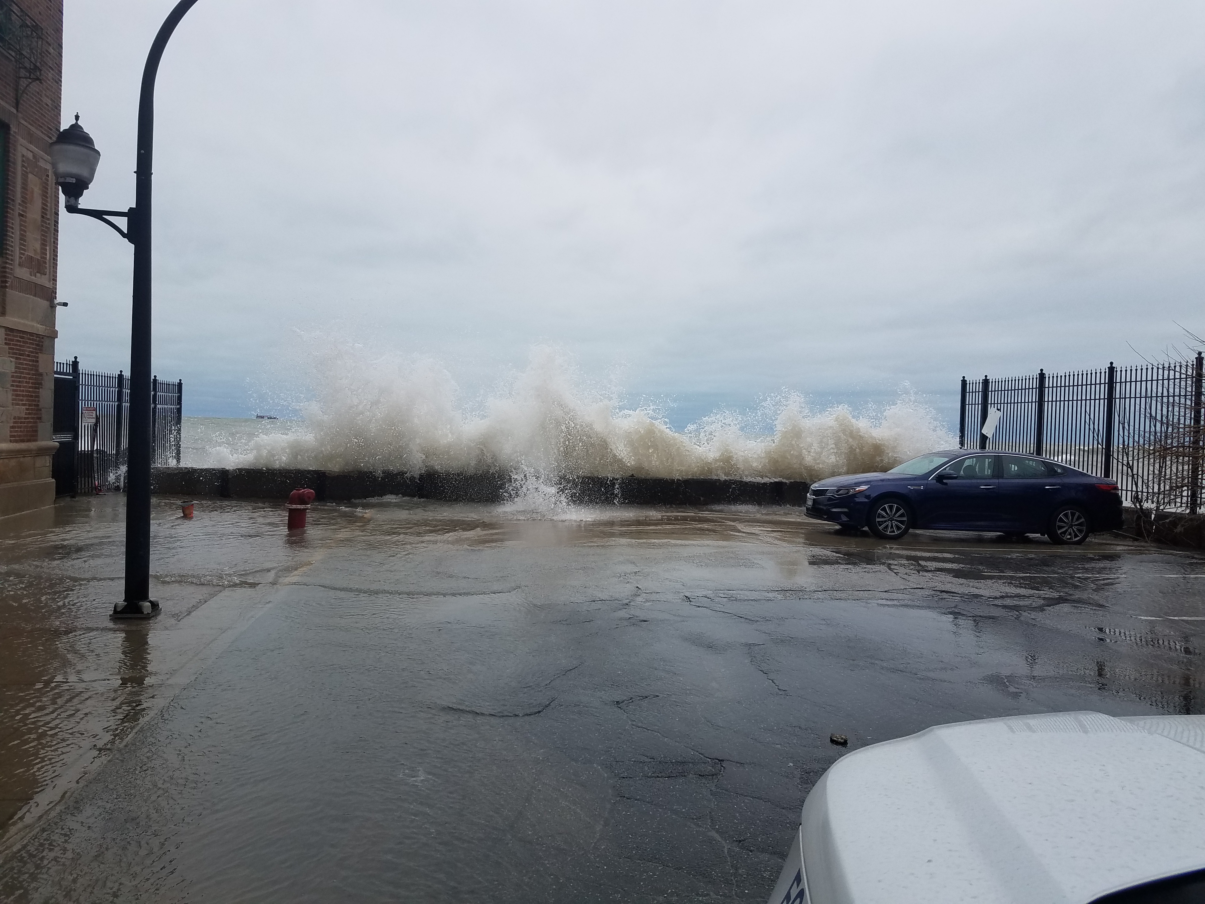
From Northwest Indiana:
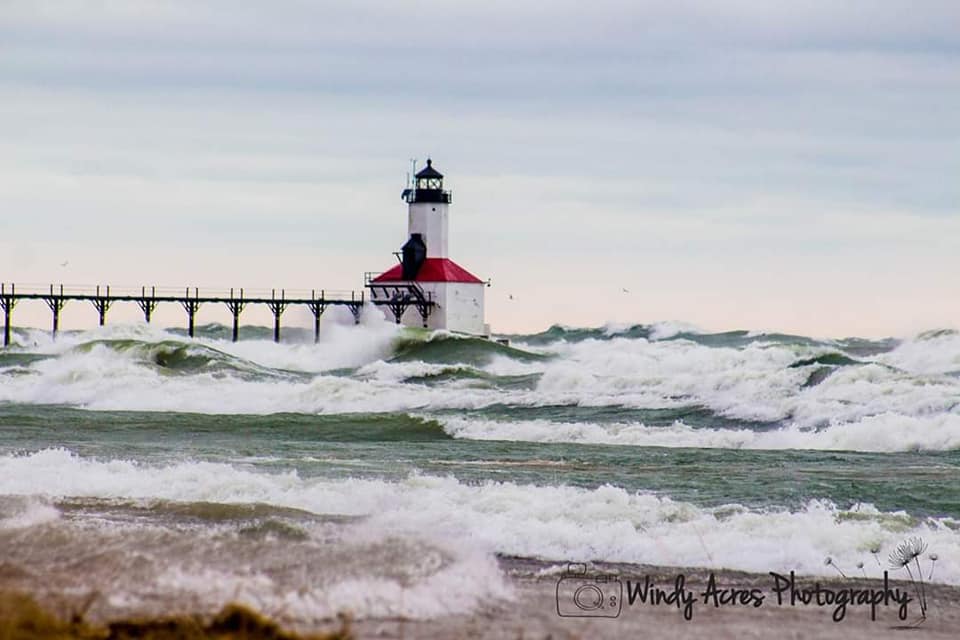 |
| Michigan City, IN courtesy of Patrick Pahl |
​
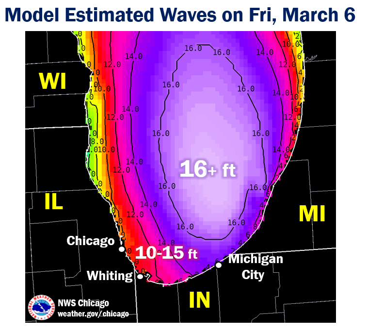
Winds
Public Information Statement
National Weather Service Chicago IL
534 PM CST Fri Mar 6 2020 /634 PM EST Fri Mar 6 2020/

...HIGHEST OBSERVED WIND GUSTS THURSDAY AND FRIDAY...

Observations are collected from a variety of sources with
varying equipment and exposures. Not all data listed are
considered official.

Land Location                Speed     Time/Date
----------------------------------------------------
Valparaiso Airport           48 MPH    0914 AM 03/06
Chicago Midway               45 MPH    0404 PM 03/05
Rockford Airport             45 MPH    0557 AM 03/06
Waukegan Airport             45 MPH    1150 AM 03/05
Sugar Grove - Aurora Arpt.   44 MPH    0324 PM 03/05
Chicago O`Hare               44 MPH    1045 AM 03/05
Wheeling - Chicago Exec. Arp 44 MPH    1211 PM 03/05
Morris Airport               41 MPH    0435 PM 03/05
Gary Airport                 41 MPH    0745 AM 03/06
Pontiac Airport              41 MPH    0855 PM 03/05
West Chicago - DuPage Arpt.  40 MPH    0617 AM 03/06
Romeoville - Lewis Airport   40 MPH    0415 PM 03/05
Peru Airport                 39 MPH    0115 AM 03/06
Kankakee Airport             38 MPH    0335 AM 03/06
Rochelle Airport             38 MPH    0315 PM 03/05
Schaumburg Airport           36 MPH    0237 AM 03/06
DeKalb Airport               36 MPH    0435 PM 03/05
Lansing Airport              36 MPH    1255 PM 03/05
Joliet Airport               36 MPH    0255 AM 03/06
Rensselaer Airport           33 MPH    0215 PM 03/05


Marine Location              Speed     Time/Date
----------------------------------------------------
Michigan City, IN            54 MPH    0900 AM 03/06
Chicago Harrison-Dever Crib  46 MPH    1230 PM 03/05
Calumet Harbor, IL           36 MPH    1130 AM 03/05
Storm Reports
PRELIMINARY LOCAL STORM REPORT...SUMMARY
NATIONAL WEATHER SERVICE CHICAGO IL
852 PM CST FRI MAR 6 2020

..TIME...   ...EVENT...      ...CITY LOCATION...     ...LAT.LON...
..DATE...   ....MAG....      ..COUNTY LOCATION..ST.. ...SOURCE....
            ..REMARKS..

1100 AM     LAKESHORE FLOOD  1 ENE BEVERLY SHORES    41.70N 86.97W
03/06/2020                   PORTER             IN   EMERGENCY MNGR

            LARGE ICE CHUNKS DEPOSITED BY THE WAVES ONTO
            LAKE FRONT DRIVE ON THE EAST END OF BEVERLY
            SHORES.

1100 AM     LAKESHORE FLOOD  1 WSW BEVERLY SHORES    41.69N 87.00W
03/06/2020                   PORTER             IN   EMERGENCY MNGR

            LAKEFRONT DRIVE CLOSED FROM BROADWAY TO
            DUNBAR DUE TO LARGE PIECES OF DEBRIS AND ICE
            CHUNKS BEING DEPOSITED ONTO THE ROAD BY THE
            WAVES. SEVERE EROSION AT LAKE VIEW BEACH
            ALSO FORCED THE CLOSURE OF THE SECTION OF
            LAKE FRONT DRIVE NEAREST THE BEACH EAST OF
            BROADWAY.

1100 AM     LAKESHORE FLOOD  BEVERLY SHORES          41.69N 86.98W
03/06/2020                   PORTER             IN   BROADCAST MEDIA

            A SEA WALL THAT PROTECTS HOMES COLLAPSED.
            REPORT FROM ABC CHICAGO.

1100 AM     LAKESHORE FLOOD  WHITING                 41.68N 87.49W
03/06/2020                   LAKE               IN   BROADCAST MEDIA

            WHITING LAKEFRONT PARK COMPLETELY INUNDATED.
            FROM ABC CHICAGO REPORT.

1100 AM     LAKESHORE FLOOD  1 ESE LINCOLN PARK      41.91N 87.62W
03/06/2020                   COOK               IL   EMERGENCY MNGR

            NORTH AVENUE BEACH COMPLETELY COVERED BY
            WATER, WITH WATER NEAR ON SITE FACILITIES.

1030 AM     LAKESHORE FLOOD  1 NNE HYDE PARK         41.81N 87.59W
03/06/2020                   COOK               IL   EMERGENCY MNGR

            LAKEFRONT PATH AT 47TH STREET FLOODED, WITH
            EROSION DAMAGE TO THE PATH NOTED.

0930 AM     LAKESHORE FLOOD  2 NNW SOUTH CHICAGO     41.76N 87.56W
03/06/2020                   COOK               IL   EMERGENCY MNGR

            IN SOUTH SHORE AREA, SOME ROADS TO LAKE SIDE
            OF SOUTH SHORE DRIVE PARTIALLY COVERED BY
            WATER. ON E 73RD STREET, WATER UP ONTO THE
            SIDEWALK AND LAPPING UP AGAINST APARTMENT
            BUILDING.
 |
Media use of NWS Web News Stories is encouraged! Additional recaps can be found on the NWS Chicago Science & Past Events Page. |
|