Chicago, IL
Weather Forecast Office
|
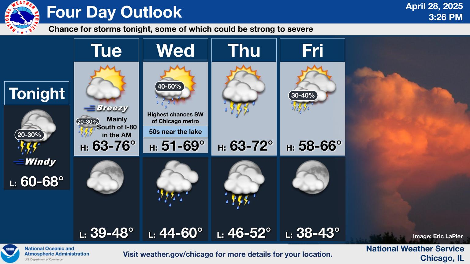
Current Conditions and Seven Day Forecast |
||

 |
|
|
|
|
Day 1
Text |
 Categorical Outlook |
 Tornado Probabilistic Outlook |
 Hail Probabilistic Outlook |
 Wind Probabilistic Outlook |
Day 2
Text |
 Categorical Outlook |
 Probabilistic Outlook |
Day 3
Text |
 Categorical Outlook |
 Probabilistic Outlook |
 Current Mesoscale Discussions |
 Current Severe Weather Watches |
 Great Lakes Radar Loop |
 Chicago Radar Loop |
 Milwaukee |
 Grand Rapids |
 Northern Indiana |
 Indianapolis |
 Central Illinois |
 Quad Cities |
 Upper Midwest Visible Satellite Image (Loop) |
 Upper Midwest Infrared Satellite Image (Loop) |
 Upper Midwest Water Vapor Satellite Image (Loop) |
US Visible (Loop) |  |
| US Infrared (Loop) |  |
|||
| US Water Vapor (Loop) |  |
 Today's Local Storm Reports |
 Yesterday's Local Storm Reports |
Hazards
Enhanced Hazardous Weather Outlook
Hazardous Weather Outlook
National Briefing
Storm Spotter Training and Seminars
Outlooks
Watch/Warning/Advisory Criteria
Snow Squall Warnings
Local Forecasts
Marine
Aviation
Fire
Text Products
Great Lakes Marine Portal
Lake Michigan Beach Forecast
El Nino
Snow and Ice Probabilities
US Dept of Commerce
National Oceanic and Atmospheric Administration
National Weather Service
Chicago, IL
250 George J Michas Dr.
Romeoville, IL 60446
815-834-1435 8am-8pm
Comments? Questions? Please Contact Us.

