National Radar Loop
Local Radar Loop
Potential for at least 2 inches of snow
Potential for at least 4 inches of snow
Potential for at least 6 inches of snow
Potential for at least 0.10 inches of ice
Potential for at least 0.25 inches of ice
Potential for at least 0.50 inches of ice
Expected Snow Forecast
Expected Ice Forecast
Graphicast
Weather Story Graphic Tab 3
Weather Story Graphic Tab 4
Weather Story Graphic Tab 5
Regional Radar Loop
Local Radar Loop
Graphical Nowcast
Local Watches, Advisories, and Warnings
National Watches and Warnings
Weather Story
Winter Storm Severity Index (Local Area)
Winter Storm Severity Index (USA)
Winter Storm Severity Index General Information
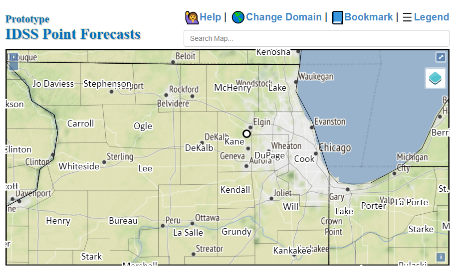
Prototype IDSS Point Forecasts Page
6-10 Day Temperature Outlook
6-10 Day Precipitation Outlook
3-7 Day Hazards Outlook
8-14 Day Temperature Outlook
8-14 Day Precipitation Outlook
8-14 Day Hazards Outlook
Day 1 Non-thunderstorm Wind Risk
NWS Chicago, IL Experimental Winter Weather Liaison Webpage This page will auto-update every 15 minutes.
If you notice old data, try reloading the page while ignoring caching by hitting Shift + F5 on a PC, or Shift + Command + R on a Mac.
Back to NWS Chicago, IL Main Page
0-36 Hours
National, Regional, and Local Radar Loops
Hourly Precipitation Graphs
Click on a location for hourly precipitation plot. Click the plot to clear the display.
These images will update around: 3:30 AM, 11:00 AM, 3:30 PM, 6:00 PM, and 9:30 PM.
Detailed Hourly Forecasts
Graphical Messaging Information
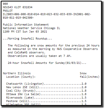
Snow and Ice Forecasts
Please see weather.gov/chicago/winter
Detailed Forecasts (Legacy Point and Click Page)
Current Conditions and
-- OR -- Hourly Weather Graph
NWS Chicago Watch/Warning/Advisory Criteria Show/Hide Map Key
Severe Weather & Flooding Winter Weather Visibility Restrictions
Tornado Warning
Blizzard Warning
Dense Fog Advisory
Severe Thunderstorm Warning
Winter Storm Warning
Dense Smoke Advisory
Flash Flood Warning
Ice Storm Warning
Dust Storm Warning
Severe Weather Statement
Wind Chill Warning
Blowing Dust Advisory
Flash Flood Statement
Winter Storm Watch
Tornado Watch
Wind Chill Watch Fire Weather
Severe Thunderstorm Watch
Winter Weather Advisory
Red Flag Warning
Flood Watch
Wind Chill Advisory
Fire Weather Watch
Flood Warning
Freezing Fog Advisory
Flood Statement
Freeze Warning Miscellaneous
Hydrologic Outlook
Freeze Watch
Hazardous Weather Outlook
Frost Advisory
Special Weather Statement
Wind
Air Quality Alert
High Wind Warning Heat
Civil Danger Warning
High Wind Watch
Excessive Heat Warning
Civil Emergency Message
Wind Advisory
Excessive Heat Watch
911 Telephone Outage
Heat Advisory
Child Abduction Emergency
Days 1.5 - 4
Weather Prediction Center Outlook Products
Graphics will update at approximately: 4 AM | 8 AM | 2 PM | 4 PM | 8 PM CST
WSSI Outlook (USA)
WSSI Outlook (Local Area)
Detailed Hourly Forecasts
Interactive Detailed Forecast Webpage
Detailed Forecasts (Legacy Point and Click Page)
Current Conditions and
-- OR -- Hourly Weather Graph
NWS Chicago Watch/Warning/Advisory Criteria Show/Hide Map Key
Severe Weather & Flooding Winter Weather Visibility Restrictions
Tornado Warning
Blizzard Warning
Dense Fog Advisory
Severe Thunderstorm Warning
Winter Storm Warning
Dense Smoke Advisory
Flash Flood Warning
Ice Storm Warning
Dust Storm Warning
Severe Weather Statement
Wind Chill Warning
Blowing Dust Advisory
Flash Flood Statement
Winter Storm Watch
Tornado Watch
Wind Chill Watch Fire Weather
Severe Thunderstorm Watch
Winter Weather Advisory
Red Flag Warning
Flood Watch
Wind Chill Advisory
Fire Weather Watch
Flood Warning
Freezing Fog Advisory
Flood Statement
Freeze Warning Miscellaneous
Hydrologic Outlook
Freeze Watch
Hazardous Weather Outlook
Frost Advisory
Special Weather Statement
Wind
Air Quality Alert
High Wind Warning Heat
Civil Danger Warning
High Wind Watch
Excessive Heat Warning
Civil Emergency Message
Wind Advisory
Excessive Heat Watch
911 Telephone Outage
Heat Advisory
Child Abduction Emergency
Days 4 - 7+
CPC and WPC Outlooks
3-10 Day Outlooks
6-10 Day Temperature Outlook 6-10 Day Precipitation Outlook Day 3-7 Hazards Outlook
Extended Outlooks
8-14 Day Temperature Outlook 8-14 Day Precipitation Outlook Day 8-14 Hazards Outlook
Detailed Forecasts (Legacy Point and Click Page)
Current Conditions and
-- OR -- Hourly Weather Graph
NWS Chicago Watch/Warning/Advisory Criteria Show/Hide Map Key
Severe Weather & Flooding Winter Weather Visibility Restrictions
Tornado Warning
Blizzard Warning
Dense Fog Advisory
Severe Thunderstorm Warning
Winter Storm Warning
Dense Smoke Advisory
Flash Flood Warning
Ice Storm Warning
Dust Storm Warning
Severe Weather Statement
Wind Chill Warning
Blowing Dust Advisory
Flash Flood Statement
Winter Storm Watch
Tornado Watch
Wind Chill Watch Fire Weather
Severe Thunderstorm Watch
Winter Weather Advisory
Red Flag Warning
Flood Watch
Wind Chill Advisory
Fire Weather Watch
Flood Warning
Freezing Fog Advisory
Flood Statement
Freeze Warning Miscellaneous
Hydrologic Outlook
Freeze Watch
Hazardous Weather Outlook
Frost Advisory
Special Weather Statement
Wind
Air Quality Alert
High Wind Warning Heat
Civil Danger Warning
High Wind Watch
Excessive Heat Warning
Civil Emergency Message
Wind Advisory
Excessive Heat Watch
911 Telephone Outage
Heat Advisory
Child Abduction Emergency
Winter Weather Watcher Training
Winter Weather Watching Tools