Virtual Tour Navigation: Go Back | Go Forward | Tour Directory
Page: 1 2 3 4 5 6 7 8 9 10 11 12 13 14 15 16 17 18
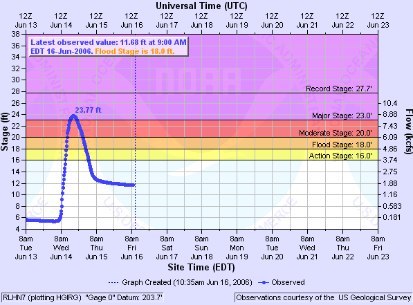
The weather isn't the only thing we forecast in the National Weather Service. Stream flow prediction is another major program in our organization. There are 13 River Forecast Centers (RFC's) across the U.S. The Southeast RFC (SERFC) serves our local hydrologic service area in central North Carolina. The SERFC is responsible for the production of river forecasts for all rivers that drain into the Atlantic Ocean along the coasts of North Carolina, South Carolina, Georgia, and Florida, as well as the rivers that drain into the Gulf of America from Mobile Bay to the southern most tip of Florida. The SERFC issues stage forecasts for specific points along rivers, special forecasts for rivers that are in flood, quantitative precipitation forecasts, and flash flood guidance.
The National Water Center (NWC), located in Tuscaloosa, Alabama, provides national guidance and services to inform essential emergency management and water resources decisions across all time scales, including drought, low-flow risks, and information needs for routine and long-range water management and planning.
The Raleigh, NWS Office will then use this information from the NWC and SERFC to write Flood Watches, Flood Warnings, Flood Statements, and routine River Summaries and Forecasts. We also collect Rainfall Observations and forward these to the SERFC.
The Hydrologist and forecast staff use a program called Hydroview which is a component of AWIPS that allows us to monitor river stages and rainfall so that we can issue timely watches and warnings. An excellent resource to view a variety of hydrologic information online is the National Water Prediction Service (NWPS) Web Page.


 Heat Safety
 Statewide Maps
 Forecaster Discussion