A heat wave over the Southwest will intensify this week, peaking and expanding into the Intermountain West and northern High Plains this weekend. Critical to extremely critical fire weather conditions are forecast from the Northwest and the northern Great Basin this weekend. Particularly Dangerous Situation Red Flag Warnings have been issued. Read More >
Tampa Bay Area, FL
Weather Forecast Office
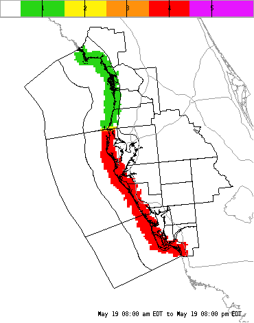
| Graphical Hazardous Weather Outlook | ||||||||||||||||||||||||||||||||||||||||||||||||||||||||||||||||||||||||
|
||||||||||||||||||||||||||||||||||||||||||||||||||||||||||||||||||||||||
Current Hazards
Outlooks
Graphical Hazards
Submit a Storm Report
Local Storm Report Map
Radar Imagery
Local KTBW Radar
Regional Radar
KTBW Radar Status
Current Conditions
Surface Observation Map
Satellite
Observed Precipitation
Local Beaches
Local Observations
Past Weather
Tropical Cyclone Reports
Weather Events
Weather History
Forecasts
Activity Planner
Aviation
Beach
Fire
Forecaster's Discussion
Graphical
Hydrology
Marine
Tropical
Probabilistic DSS
Climate
National
Local
Records and Normals
1991-2020 Climate Normals
Local Drought/Rainfall
Thunderstorm Climatology
El Niño Southern Oscillation
Arctic Oscillation
Climate Summaries
US Dept of Commerce
National Oceanic and Atmospheric Administration
National Weather Service
Tampa Bay Area, FL
2525 14th Ave. SE
Ruskin, FL 33570
(813) 645-2323
Comments? Questions? Please Contact Us.