Updated: 9/5/23
The following data is mainly based on the official Atlantic basin tropical cyclone (TC) database (HURDAT), which includes known tropical depressions (TD), tropical storms (TS) and hurricanes (H) back to 1851. Refer to the National Hurricane Center data archive page and NOAA Historical Hurricane Tracks website for more information.
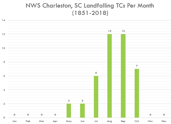
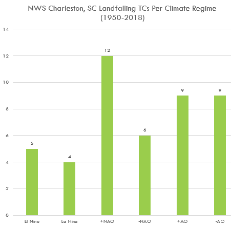
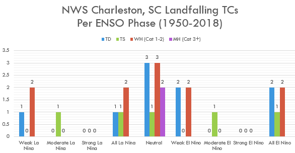
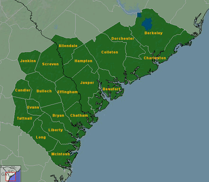
More local tropical cyclone statistics can be found here.
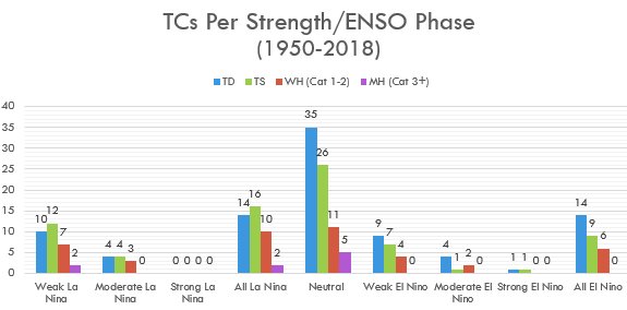
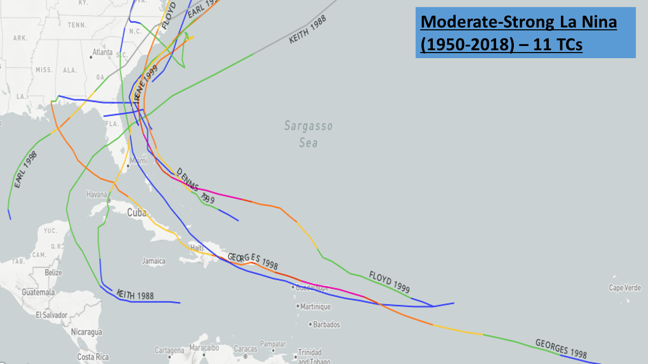
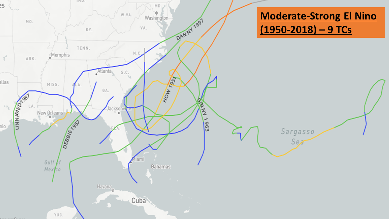
2019 Climatological Study:
Notable Storms:
Year |
Date(s) |
Name/# |
Notes/Impacts to the SC Lowcountry and GA Coastal Empire |
| Pre-1800 | |||
| 1686 | Sep 4-5 | "Spanish Repulse" | Likely made landfall near Charleston causing extensive damage to ships, trees, crops, houses and livestock, and killed many people. After the storm, the Spanish aborted an invasion and turned back to FL. |
| 1700 | Sep 14 | "Rising Sun" | Likely made landfall north of Charleston causing severe storm surge flooding despite winds shifting just before high tide, damage to several ships, including the 800-ton Scottish ship "Rising Sun", and 100+ deaths. |
| 1713 | Sep 16-17 | "Great Storm" | Extremely destructive hurricane made landfall north of Charleston causing significant property damage and at least 70 deaths. |
| 1722 | Sep 19-21 | Likely made landfall near Savannah causing significant flooding with the Savannah River over-spilling its banks. | |
| 1728 | Aug 13-14 | Likely made landfall just south of Charleston causing significant damage to ships, houses, wharfs, bridges and crops. | |
| 1752 | Sep 13-15 | "Great Hurricane" | Very strong (but likely small) hurricane made landfall just south of Charleston near high tide producing severe storm surge flooding (~17 ft MLW at Charleston), much property/crop/livestock damage and at least 95 deaths. It is likely the worst storm to ever hit Charleston. The storm occurred around the transition from the Julian to Gregorian calendars. |
| 1783 | Oct 6-8 | Strong hurricane tracked along the coast causing significant property damage but not as much flooding as the 1752 storm. | |
| 1800s | |||
| 1804 | Sep 6-8 | Large, violent (likely Cat 3 or 4) hurricane moved north near the GA coast before likely moving inland over southern SC. Produced significant wind/water damage around Charleston and killed hundreds of people. | |
| 1811 | Sep 8-10 | Hurricane likely made landfall south of Charleston causing a tornado which caused a lot of damage in the city. | |
| 1813 | Aug 27 | Brief but violent hurricane caused significant property damage and storm surge flooding similar to the 1752 storm and worse than the 1804 storm. | |
| 1822 | Sep 27 | Landfall just north of Charleston, SC as a small likely Cat 3 hurricane producing severe damage, mainly around the Santee River. | |
|
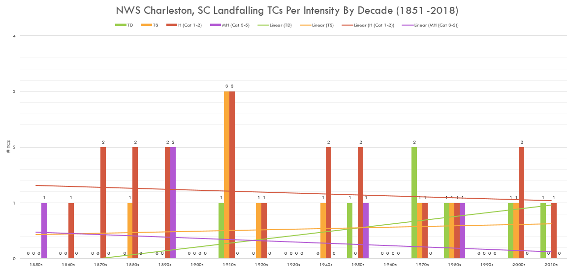
Official Records Begin in 1851 **Storms highlighted in red made landfall in the NWS Charleston County Warning Area (CWA)** |
|||
| 1854 | Sep 7-9 | "Great Carolina" | Landfall just south of Savannah, GA as a large Cat 3 hurricane and then slowly tracked just east of Statesboro, GA as a Cat 1 hurricane before weakening to a TS as it crossed the Savannah River into Allendale County, SC. Although most of the significant wind damage was near/south of Charleston, SC, substantial storm surge flooding occurred well northward along the SC coast ruining many crops. |
| 1867 | Jun 21-23 | ***Earliest landfalling hurricane in the NWS Charleston CWA*** Landfall at Isle of Palms, SC on June 22 as a Cat 1 hurricane and then weakened to a TS before moving through the Pee Dee and into central NC. | |
| 1874 | Sep 27-28 | Landfall on Seabrook Island, SC as a Cat 1 hurricane. Produced downed telegraph lines and extensive wharf/crop damage in Charleston along with 2 deaths. | |
| 1878 | Sep 10-12 | Landfall just south of Charleston, SC as a Cat 1 hurricane. Produced significant crop damage. | |
| 1881 | Aug 26-28 | Landfall just south of Savannah, GA as a Cat 2 hurricane with winds ~105 mph before moving west into central GA and weakening into a TS. Produced significant surge flooding, property/crop damage and 700 U.S. deaths. | |
| 1884 | Sep 9-13 | Landfall south of Savannah, GA on St. Catherine's Island as a TS. Weakened to a TD over land and re-curved out to sea off the SC coast before re-strengthening to a TS. | |
| 1885 | Aug 24-25 | Landfall at Kiawah Island, SC as a Cat 2 hurricane causing significant damage along the GA/SC coasts northward through around Pawley's Island, SC and at least 21 deaths. | |
| 1893 | Aug 27-28 | "Great Sea Islands" | ***Earliest landfalling major hurricane in the NWS Charleston CWA*** Landfall just south of Savannah, GA on August 28 as a very large Cat 3 hurricane with peak winds near 115 mph and minimum pressure of 954 mb. Moved north-northeast through the SC Midlands and weakened to a Cat 1 hurricane before reaching Columbia, SC. The storm tide along the coast was catastrophic, a combination of the ~16 foot storm surge and the high astronomical tides. Significant wind/water damage occurred northward through around Charleston and at least 1,000 (possibly 2,000+) people were killed in the U.S.. Fortunately, Savannah was spared complete inundation and less damage/deaths occurred in Charleston compared to the 1885 storm. However, the storm essentially marked the beginning of the end of rice cultivation and the phosphate industry in the region. |
| 1893 | Oct 12-13 | Moved northeast off the coasts of GA before making landfall along the SC coast just north of Charleston as a compact Cat 3 hurricane with 120 mph winds and minimum central pressure of 955 mb. Produced significant flooding due to already wet ground from previous storms. | |
| 1894 | Sep 26-27 | Landfall on Hilton Head Island, SC as a Cat 1 hurricane before moving northeast and passing just west of Charleston with winds around 80 mph. | |
| 1896 | Sep 29 | Tracked through southeast GA as a Cat 2/3 hurricane and through southeast SC as a Cat 1/2 hurricane. Produced significant wind damage around Savannah, GA and Beaufort, SC. | |
| 1898 | Aug 30-31 | Landfall on Hilton Head Island, SC as a Cat 1 hurricane. Produced significant wind damage around Savannah and saltwater from the storm surge wrecked rice crops along the Savannah and Ogeechee Rivers. | |
| 1898 | Oct 1-3 | Landfall on Cumberland Island, GA as a Cat 4 hurricane with winds near 130 mph. Moved northwest into central GA and weakened to a Cat 1 hurricane over Telfair County and then to a TS southwest of Macon. Produced a storm tide near 20 feet on Jekyll Island (with some significant flooding even around Savannah, GA), significant property damage across southeast GA and 179 U.S. deaths. | |
| 1900s | |||
| 1911 | Aug 27-30 | Landfall on Hilton Head Island, SC as a Cat 2 hurricane with winds near 100 mph. Moved slowly westward and weakened into a TS before reaching Statesboro, GA. Wind gusts reached 110 mph in Beaufort, SC, 96 mph in Savannah, GA, 95 mph on Edisto Island, SC and 94 mph at Charleston, SC (before the Weather Bureau's anemometer broke) causing many trees, power lines, and telegraph lines to fall. A significant storm surge produced extensive flood damage, especially from around Beaufort to Charleston. Much of the rice crops were destroyed, effectively ending the region's rice industry. | |
| 1912 | Jul 14-16 | Landfall near Altamaha Sound, GA as a TS. Slowly moved west across southern GA producing heavy rain. | |
| 1912 | Sep 5-6 | TS moved southwest off the SC coast before weakening into a TD and then making landfall on Ossabaw Island, GA. | |
| 1913 | Oct 7-10 | Landfall on Cape Island, SC just north of Charleston as a Cat 1 hurricane. Produced heavy rain, especially in northeast SC, including 4"+ at Charleston. | |
| 1916 | May 15-16 | ***Earliest landfalling tropical storm in the NWS Charleston CWA*** Landfall on Fripp Island, SC as a TS on May 16. | |
| 1916 | Jul 13-15 | Landfall at Bulls Bay, SC as a compact Cat 2 hurricane. The storm moved slowly and produced very heavy rain which caused severe river flooding. In fact, the Santee River at Jamestown observed the highest water level on record. Damage was most significant north of Charleston and likely the worst in that area since the 1822 hurricane. | |
| 1916 | Oct 3-5 | Landfall on Sapelo Island, GA as a TS. | |
| 1927 | Oct 2-3 | Landfall near Edisto Beach, SC as a TS. | |
| 1928 | Sep 18 | "Lake Okeechobee" | Landfall between Beaufort, SC and Charleston, SC as a Cat 1 hurricane. Produced some wind damage, mainly downed trees and power/phone lines, 11"+ of rain in Savannah, GA which caused significant flooding and ~$1 million in damage in Charleston. |
| 1940 | Aug 10-13 | Landfall near Hilton Head Island, SC as a Cat 2 hurricane with winds near 100 mph. Produced significant storm surge, 10+ inches of rain (mostly across SC). | |
| 1945 | Sep 16-17 | Landfall near the GA/SC border as a TS. Produced gusts near 90 mph at Paris Island, SC, moderate flooding, and tornadoes with $6-7 million damage. | |
| 1947 | Oct 14-16 | Landfall on Ossabaw Island, GA just south of Savannah as a Cat 2 hurricane with winds near 105 mph. Produced minor to moderate damage in Savannah as well as above normal tides in Charleston where minor flooding occurred. The lowest pressure at Savannah was 28.77 in Hg (974 mb), which is the 3rd lowest on record. | |
| 1950 | Sep 6-7 | Easy | TD moved through southern GA. Produced very heavy rainfall, especially across coastal GA where 15+ inches fell (Savannah, GA recorded 16" inches). |
| 1952 | Aug 30-31 | Able | Landfall near Beaufort, SC as a Cat 2 hurricane with sustained winds near 100 mph and minimum central pressure near 980 mb. Produced 90 mph winds at Beaufort, heavy rainfall over eastern SC and 2 deaths and $3 million in damage in SC. |
| 1953 | Aug 31-Sep 1 | TS approached the GA coast but weakened into a TD before making landfall south of Savannah, GA. The storm then moved inland through southeast GA and dissipated over central GA. | |
| 1954 | Oct 14-15 | Hazel | Brushed the SC Lowcountry and made landfall near the SC/NC border as a Cat 4 hurricane with sustained winds near 130 mph, the strongest storm on record to make landfall that far north. Caused 95 deaths in the U.S. and was one of the worst storms on record in SC with significant damage, mainly from Pawleys Island northward. |
| 1959 | Jul 4-9 | Cindy | Landfall just north of Charleston, SC near Bulls Bay as a Cat 1 hurricane with winds near 75 mph winds. 64 mph winds were recorded at McClellanville along with 1 death. Storm tides were ~4 feet above normal and heavy rain fell. |
| 1959 | Sep 28-30 | Gracie | Landfall near Beaufort, SC as a Cat 4 hurricane with sustained winds near 130 mph and minimum pressure of 951 mb. Moved northwest past Columbia and weakened into a TS before moving into NC producing heavy rainfall which led to significant flooding as well as severe crop damage. Although a significant storm surge occurred (~9 feet at Charleston Harbor), the resulting flooding would have been much worse if the storm hit at high tide instead of low tide. The highest recorded storm tide was ~12 feet above mean low water (MLW) at Edisto Beach, SC. The relatively slow speed of the storm helped cause extensive wind/flooding damage across southeast SC, mainly in the Beaufort to Charleston corridor, along with 10 deaths in GA and SC. For more info, check out the NHC archive. |
| 1960 | Sep 11 | Donna | Landfall in the FL Keys as a Cat 4 hurricane and then moved northeast while weakening to a Cat 1 and then re-strengthening to a Cat 2 off the SC coast. Produced heavy rain, gusts near 70 mph on the coast near Charleston, tides ~2 feet above normal and a tornado that injured ~10 people and caused considerable damage in the Charleston area. |
| 1971 | Sep 10-11 | Landfall near Charleston, SC as a TD and then dissipated before moving west into GA. | |
| 1976 | Aug 19-21 | Dottie | Landfall near Charleston, SC as a TS before dissipating north of Lake Moultrie. |
| 1979 | Jun 15-16 | TD approached the central SC coast from the south and made landfall near Kiawah Island before dissipating east of Columbia. Produced ~1-3 inches of rainfall across the area. | |
| 1979 | Sep 4-5 | David | Landfall on Sapelo Island, GA as a Cat 1 hurricane with winds ~90 mph. Produced 5 tornadoes, heavy rainfall (including 6.86" at Savannah), significant storm surge and beach erosion and ~$10 million in damage in SC. Savannah, GA recorded its 2nd lowest pressure on record (28.65" Hg / 970 mb). |
| 1981 | Jul 3 | TD moved north along the FL east coast and made landfall on Fripp Island, SC. | |
| 1985 | Jul 24-25 | Bob | Landfall on Fripp Island, SC as a Cat 1 hurricane. Produced a 44 mph wind gust in downtown Charleston, SC and a 48 mph gust at Folly Beach, SC. 5" of rain fell at the Charleston Airport. |
| 1988 | Aug 28 | Chris | Landfall near Savannah, GA as a TS. Produced heavy rainfall (~3 inches over eastern SC). |
| 1989 | Sep 21-22 | Hugo | Landfall at Sullivan's Island, SC as a Cat 4 hurricane with sustained winds near 140 mph producing very significant damage near Charleston. The peak wind gust in Downtown Charleston was 108 mph, at Folly Beach it was 107 mph and in North Charleston at the airport it was 98 mph. Landfall occurred just before high tide but still resulted in peak storm tides of ~20 feet above mean sea level at Romain Retreat, SC and 10-12 feet above mean sea level in Charleston Harbor. Rainfall amounts were limited due to the fast motion of the storm, although up to ~10 inches still occurred in southeast SC (highest total was 10.28 inches at Edisto Island). Check out our 25th anniversary video series in 2014 about the storm and its impacts! |
| 1995 | Aug 24-27 | Jerry | Landfall near Palm Beach, FL as a TS and then slowly moved northwest toward the Big Bend area and weakened to a TD before moving north into east-central GA and eventually dissipating northwest of Augusta. Produced heavy rainfall, including a widespread area of 7+ inches over the Lowcountry/Coastal Empire and 10+ inches in some spots, including ~13 inches at Hilton Head Island, SC, ~11 inches at Savannah Airport, and ~7 inches at Charleston Airport. |
| 1999 | Sep 15 | Floyd | Floyd was a large and intense Cape Verde storm that pounded parts of the Bahamas and threatened the entire Southeast U.S. coast. Floyd neared Cat 5 intensity in the Bahamas; however, it weakened thereafter and was a Cat 2 as it made landfall near Cape Fear, NC. Produced a 53 mph wind gust at the Savannah Airport and an 85 mph gust in Downtown Charleston. The minimum pressure at the Charleston Airport was 989.5 mb while rainfall totaled ~4 inches at the Charleston Airport and in Downtown Charleston. |
| 2000s | |||
| 2002 | Oct 11-12 | Kyle | Moved north-northeast along the GA/SC coasts before making landfall near McClellanville, SC as a TS. Produced heavy rainfall across coastal southeast GA and southeast SC (2.25 inches at the Savannah Airport and 4.91 inches at the Charleston Airport). |
| 2003 | Jul 25-26 | #7 | TD developed off the FL coast near Daytona Beach and moved northwest before making landfall at Sapelo Island, GA and then dissipating over central GA. Produced heavy rainfall, including ~5 inches near Savannah. |
| 2004 | Aug 14 | Charley | Landfall at Cape Romain, SC as a Cat 1 hurricane. Produced a peak wind gust of 38 mph and 1.02 inches of rain at the Charleston Airport. |
| 2004 | Aug 28-29 | Gaston | Landfall near Awendaw, SC as a Cat 1 hurricane. Produced a peak wind gust of 55 mph and 4.05 inches of rain at the Charleston Airport and 4.63 inches in Downtown Charleston. |
| 2004 | Sep 5-7 | Frances | Landfall on the FL coast near Stuart as a Cat 2 hurricane. The storm then moved into the northeast Gulf of Mexico and made a second landfall along the Big Bend area of FL as a TS before moving into western GA and dissipating into a TD. 20 tornadoes were documented across southeast SC and northern portions of southeast GA. |
| 2004 | Sep 26-28 | Jeanne | Landfall near Stuart, FL as a Cat 3 hurricane. The storm then moved up the west coast of FL and weakened into a TS before continuing into central GA and upstate SC as a TD. The storm produced ~1-3 inches of rain and 6 confirmed weak tornadoes across southeast SC and northern portions of southeast GA. |
| 2005 | Oct 5-6 | Tammy | Landfall near Atlantic Beach, FL as a TS. Moved northwest into southeast GA before weakening into a TD. Produced very heavy rainfall over southeast GA/SC, including localized amounts near 10 inches, especially over southeast GA where over 14 inches fell around Darien causing significant flooding. |
| 2006 | Jun 13-14 | Alberto | Landfall along the Big Bend area of FL as a TS. Moved northeast into southeast GA and weakened to a TD before moving into central SC and becoming an extra-tropical storm. Produced ~2-5 inches of rain across southeast SC/GA (3.29 inches of rain at the Savannah Airport and 2.51 inches at the Charleston Airport) with locally higher amounts ~7 inches (7.05 inches at Rincon, GA). In addition, 7 tornadoes were documented across southeast SC/GA in NWS Charleston's County Warning Area. |
| 2016 | May 28-30 | Bonnie | Developed north of the Bahamas and strengthened into a TS as it move northwest toward the GA/SC coasts, eventually weakening to a TD before making landfall near Charleston. Produced heavy rainfall (widespread 3-7 inches with local amounts over 10 inches), mainly north of I-16, which led to significant flooding. |
| 2016 | Jun 6-7 | Colin | Developed north of the Yucatan Peninsula and moved northeast while strengthening into a TS before making landfall around the Big Bend area of FL. Moved through southeast GA and then near the SC coast as a TS. Produced heavy rainfall (mainly 2-3 inches with locally higher amounts over 4 inches), which led to some flooding. Also produced some coastal flooding due to high storm tides. |
| 2016 | Sep 1-3 | Hermine | Made landfall around the Big Bend area of FL as a Cat 1 hurricane and then moved northeast just inland through southeast GA and SC as a TS. Produced widespread tropical storm force wind gusts (60+ mph near the coast), heavy rainfall (widespread 3-5 inches with locally higher amounts over 8 inches toward the SC Midlands), and 2 EF-1 tornadoes (1 in Liberty County, GA and 1 in Chatham County, GA). |
| 2016 | Sep 14-15 | Julia | Developed near Jacksonville, FL as a TS and moved north and then northeast near the GA coast and then southern SC coast before moving east away from the coast and weakening to a TD. The storm then meandered well offshore while strengthening into a TS again and then weakening into a TD before dissipating. |
| 2016 | Oct 7-8 | Matthew | Moved north and then northwest through the Caribbean Sea and then through the Bahamas while strengthening to a Category 4 hurricane. Tracked just off the east coast of FL and GA while weakening to a Category 1 storm before making landfall near McClellanville, SC with winds near 85 mph. Produced hurricane force wind gusts along the entire coast, significant coastal flooding from high storm tides (including a record level at Fort Pulaski), and very heavy rainfall (widespread 6 to 12 inches with locally higher amounts near 17 inches) which led to significant freshwater flooding. |
| 2017 | Sep 10-11 | Irma | Made landfall in the FL Keys as a Cat 4 hurricane and then moved along the southwest coast of FL as a Category 3 hurricane. The storm then moved north near the west coast of FL while weakening to a TS before moving into southwest GA and continuing to weaken. Produced significant coastal flooding, rainfall flooding, and river flooding as well as near hurricane-force wind gusts and 4 tornadoes. |
| 2018 | Sep 14-15 | Florence | Made landfall near Wrightsville Beach, NC as a Cat 1 hurricane and then slowly shifted southwest into northeast SC as a TS. Produced TS force wind gusts and heavy rain across the Charleston tri-county region but no significant impacts occurred. |
| 2019 | Sep 4-5 | Dorian | Cat 3 hurricane slowly moved north off the GA coast and then more northeast off the SC coast while weakening to a Cat 2 hurricane. Produced sustained TS force winds, hurricane force wind gusts, heavy rain and some coastal flooding, especially along the SC coast. |
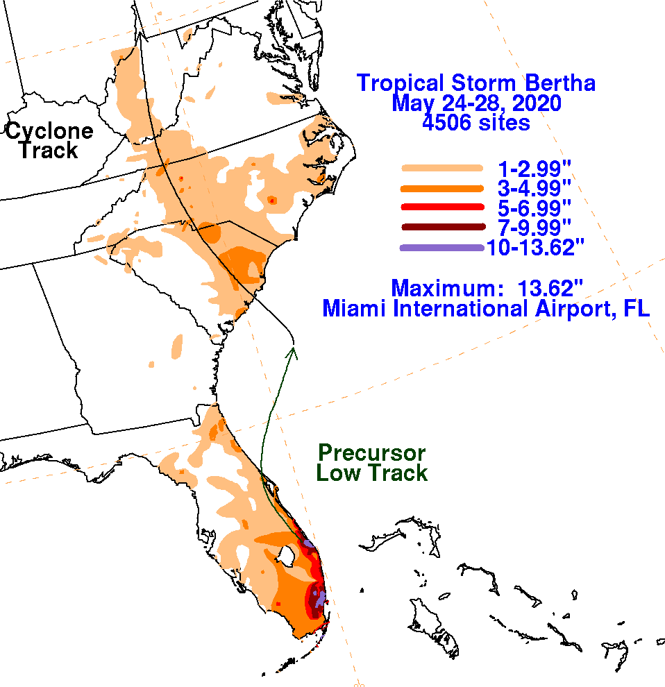
| 2020 | May 27 | Bertha | Developed just off the SC coast and made landfall near Isle of Palms, SC as a TS. Produced some heavy rain and minor wind damage. |
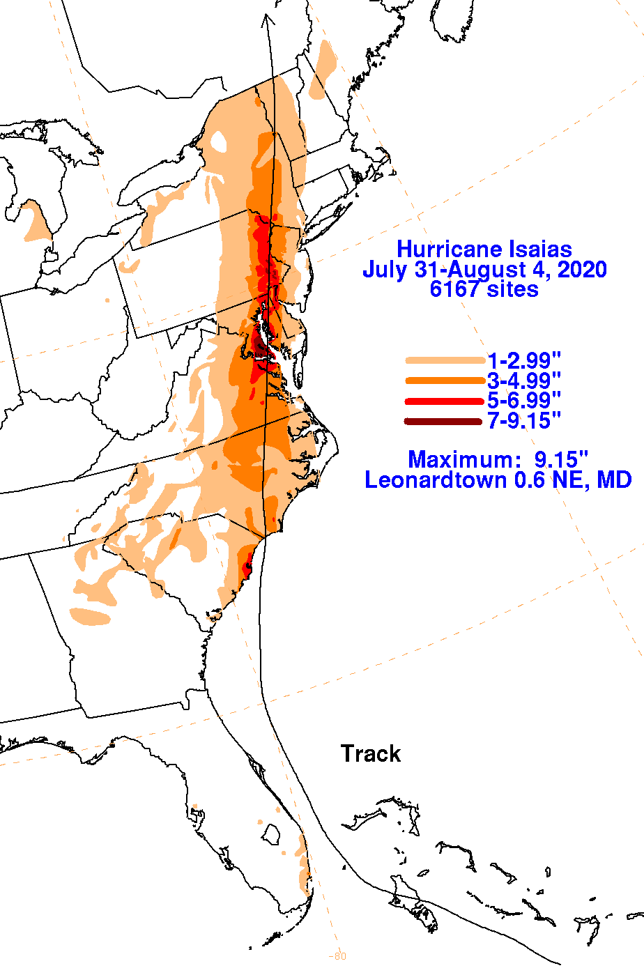
| 2020 | Aug 3 | Isaias | Tracked north-northeast just off the GA/SC coasts as a TS before strengthening to a Cat 1 hurricane ~50 miles east of Charleston, SC. Produced TS force wind gusts and heavy rain, mainly northeast of Charleston. |
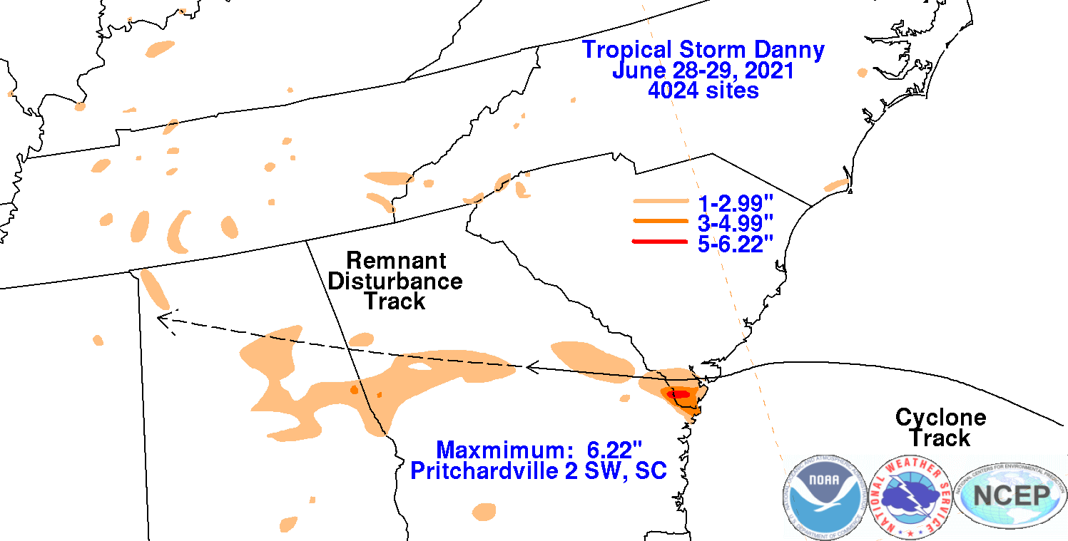
| 2021 | Jun 28-29 | Danny | Landfall on Pritchards Island, SC as a very weak TS. Produced some heavy rain (~3-6") which caused some flooding. |
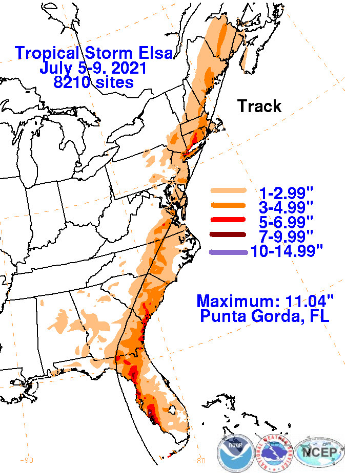
| 2021 | Jul 7-8 | Elsa | Tracked northeast through southeast GA/central SC as a TS. Produced some significant impacts from hurricane force wind gusts and heavy rain (8+ inches), mainly near the northern GA/southern SC coasts. |
| 2022 | Sep 30 | Ian | On Friday, September 30, 2022 Hurricane Ian made landfall near Georgetown, SC as a Category 1 Hurricane. Ian impacted the South Carolina Lowcountry with strong gusty winds and torrential rainfall producing several flash flooding events. |
| 2022 | Nov 10-11 | Nicole | Nicole made landfall as a Category 1 Hurricane just south of Vero Beach, FL on Nov 10th. The system weakened to a tropical storm over inland FL, then weakened to a depression as it tracked over SW GA. The system produced widespread rainfall across SE GA and SC, generally ranging between 1.5 to 3 inches. |
| 2023 | Aug 30 | Idalia | Idalia moved from the northeastern Gulf of Mexico region up through southeast GA and southeast SC before exiting back into the Atlantic just south of Myrtle Beach, SC. Tropical storm force winds were felt all along the southeast GA and southeast SC coastline. Very heavy rain fell across inland areas west of the Interstate-95 corridor leading to flooding in a number of locations. Idalia's passage coincident with high tide resulted in a damaging storm surge across portions of the SC coast. |
References:


 Coastal Flood