Overview
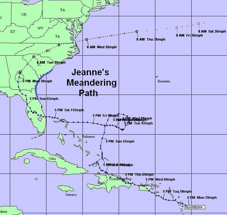
Jeanne took a long time to make it to her eventual landfall in Florida, but then quickly found her way up the Appalachians, and into the Mid-Atlantic. When she arrived here, she made lots of rain!
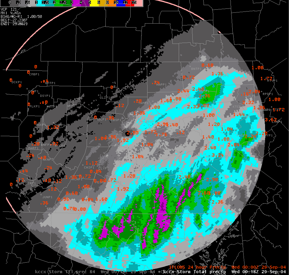
Rainfall from Hurricane Jeanne was up to 4 inches in many locations across the lower Susquehanna Valley. The map below is the radar's rainfall estimate using the Tropical-rainfall relationship. The highest rainfall report we received was 5 inches in western Adams County (in both Fairfield and Cashtown). See the text list below the picture for details on the reports received so far (as of 8 pm EDT Mon). Widespread flooding of most creeks and streams, as well as the smaller rivers and tributaries (of the Main Stem Susquehanna) occurred.
 |
 |
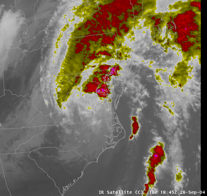 |
| Jeanne's Meandering Path | Rainfall Through 8pm EDT Monday | IR Satellite Imagery |
Flooding
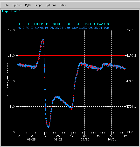
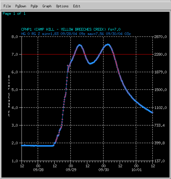
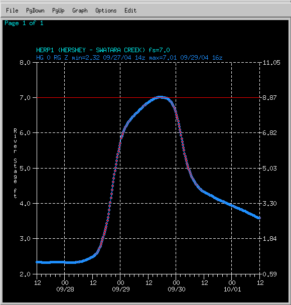
Hydrographs
 |
 |
 |
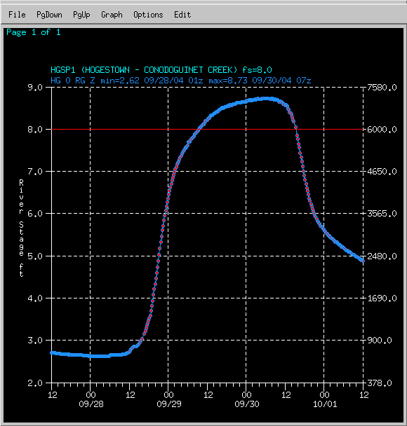 |
| Bald Eagle Creek at Beech Creek | Yellow Breeches Creek near Camp Hill | Swatara Creek near Hershey | Conodoguinet Creek near Hogestown |
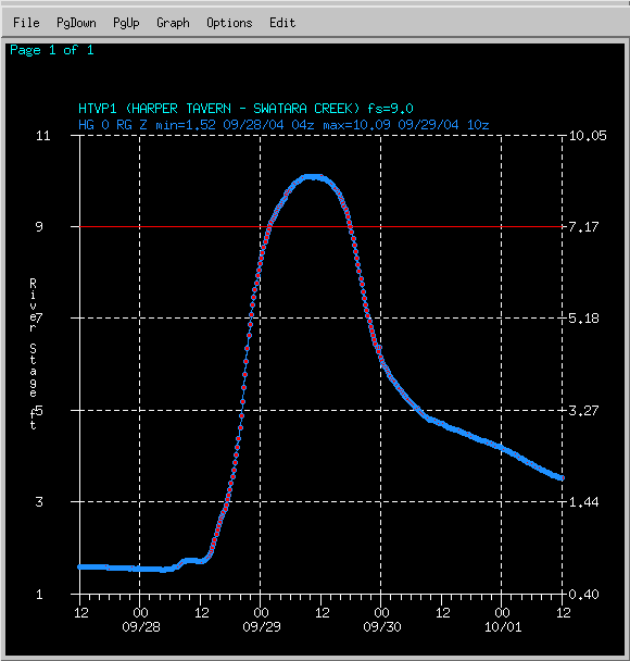 |
| Swatara Creek at Harper Tavern |
Rain Reports
...PRELIMINARY STORM TOTAL RAINFALL REPORTS RECEIVED FROM MIDNIGHT
TUESDAY THROUGH 8:50 PM TUESDAY NIGHT...

                           STORM TOTAL(INCHES)   REPORT TIME

...ADAMS COUNTY...
BUCHANAN VALLEY                 4.70                8:59 PM
BIGLERVILLE                     1.14                12 NOON
CASHTOWN                        5.00                8:47 PM
FAIRFIELD                       5.00                5:46 PM

...BEDFORD COUNTY...
BUFFALO MILLS                   0.53                12 NOON
EVERETT                         1.09                12 NOON
SAXTON                          1.20                12 NOON
WOLFBURG                        0.69                12 NOON

...BERKS...
READING                         2.47                8:00 PM

...BLAIR COUNTY...
ALTOONA                         0.75                8:00 PM
TYRONE                          1.22                12 NOON
WILLIAMSBURG                    1.03                12 NOON

...CAMBRIA COUNTY...
EBENSBURG                       0.41                12 NOON
JOHNSTOWN                       0.55                8:00 PM
...CAMERON COUNTY...
SINNEMAHONING                   0.07                12 NOON
STEVENSON DAM                   0.02                12 NOON

...CENTRE COUNTY...
MILLHEIM                        0.79                12 NOON
PHILIPSBURG 2S                  1.00                12 NOON
STATE COLLEGE                   2.19                8:50 PM

...CLEARFIELD COUNTY...
CLEARFIELD                      0.29                8:00 PM

...CLINTON COUNTY...
CASTANEA                        3.1                 4:00 PM
LOCK HAVEN                      1.85                12 NOON
RENOVO                          0.44                12 NOON

...COLUMBIA COUNTY...
BENTON                          0.64                12 NOON

...CUMBERLAND COUNTY...
CARLISLE                        3.00                5:35 PM
MOUNT HOLLY SPRINGS             3.25                5:35 PM
PINE GROVE FURNACE              0.75                12 NOON
SHIPPENSBURG                    1.34                12 NOON
SHIREMANSTOWN                   2.88                4:25 PM

...DAUPHIN COUNTY...
DEHART DAM                      0.58                12 NOON
HARRISBURG                      3.47                8:00 PM
HARRISBURG 1 NE                 0.27                12 NOON

...FRANKLIN COUNTY...
SOUTH MOUNTAIN                  0.46                12 NOON
UPPER STRASBURG                 0.94                12 NOON
FAYETTEVILLE                    2.12                1:20 PM
WAYNESBORO                      2.52                2:30 PM

...HARFORD COUNTY MD...
CONOWINGO DAM                   0.12                12 NOON

...HUNTINGDON COUNTY...
RAYSTOWN LAKE                   1.01                12 NOON

...LANCASTER COUNTY...
GLEN MOORE                      0.11                12 NOON
LANCASTER                       1.77                8:00 PM
NEW HOLLAND                     0.05                12 NOON
SAFE HARBOR                     0.03                12 NOON

...LYCOMING COUNTY...
MOUNTGOMERY                     1.75                7:25 PM
WILLIAMSPORT                    1.89                8:30 PM

...MCKEAN COUNTY...
PORT ALLEGHENY                  0.03                12 NOON

...MIFFLIN COUNTY...
LEWISTOWN                       0.69                12 NOON

...NORTHUMBERLAND COUNTY...
HERNDON                         2.25                6:45 PM
SUNBURY                         0.70                12 NOON

...POTTER COUNTY...
OSWAYO                          0.01                12 NOON

...SCHUYLKILL COUNTY...
MAHANOY CITY                    0.57                12 NOON
PINE GROVE                      0.38                12 NOON

...SNYDER COUNTY...
SELINSGROVE                     1.69                8:00 PM

...SOMERSET COUNTY...
CONFLUENCE                      0.10                12 NOON
GLENCOE                         0.47                12 NOON
LAUREL SUMMIT                   0.30                12 NOON
MEYERSDALE                      0.27                12 NOON
SOMERSET                        0.31                12 NOON

...SUSQUEHANNA COUNTY...
MONTROSE                        1.32                12 NOON

...TIOGA COUNTY...
COVINGTON                       0.30                12 NOON
SABINSVILLE                     0.07                12 NOON

...UNION COUNTY...
LEWISBURG                       0.48                12 NOON

...WARREN COUNTY...
CHANDLERS VALLEY                0.05                12 NOON

...YORK COUNTY...
CAPITAL CITY AIRPORT            3.81                8:00 PM
HANOVER                         0.96                12 NOON
THOMASVILLE                     2.75                8:00 PM

$$

CRUZ
 |
Media use of NWS Web News Stories is encouraged! Please acknowledge the NWS as the source of any news information accessed from this site. |
|


 Send Us a Report