Overview
|
An early season (pre-Halloween) Snow event occurred on October 24th and 25th giving Central Pennsylvania its first taste of winter. The event started out as as rain when moisture associated with the remnants of Hurricane Wilma and Tropical Storm Alpha streamed up along the East Coast. This tropical moisture was also tapped by a developing East Coast low pressure center that developed in response to an upper level disturbance moving over the region. As colder air moved into Pennsylvania behind the low on Oct 25th much of the rain mixed with and changed to wet snow across Northern and Central Pennsylvania, especially at higher elevations above 1500 feet. |
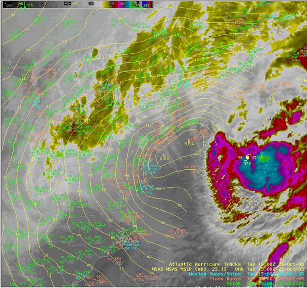 Pre-Halloween Snowfall and Heavy Rain Event Associated with Tropical Moisture from Hurricane Wilma |
 |
 |
 |
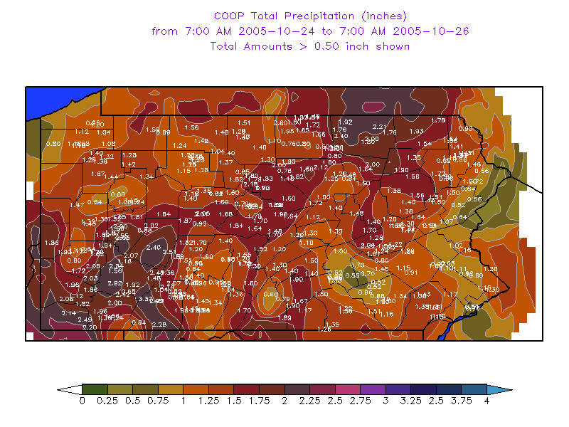
| Snowfall Reports | 48 Hour COOP Rainfall 7:00 am Oct 24 through 7:00 am Oct 26 |
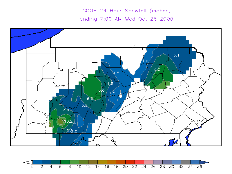
24 Hour COOP Snowfall Ending 7:00 am Oct 26 |
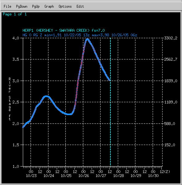
Flooding
Hydrographs
 |
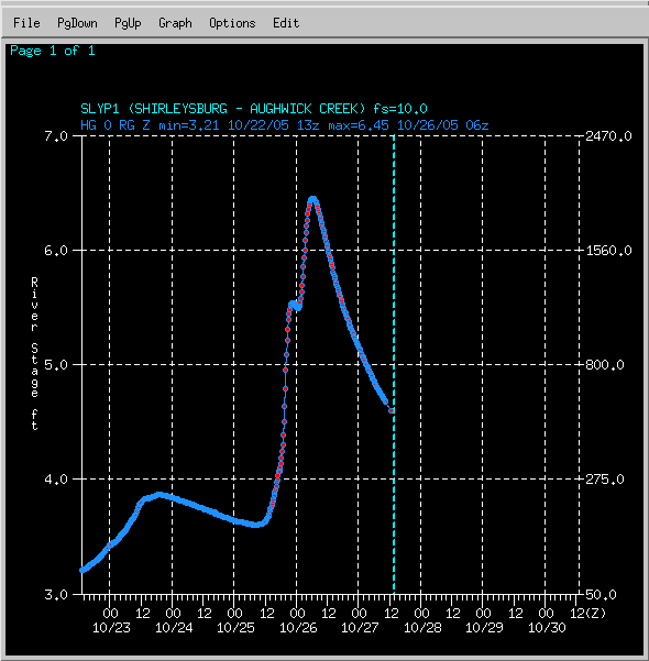 |
| HERP1 - Swatara Creek at Hershey | SLYP1 - Aughwick Creek at Shirleysburg |
Snow and Rainfall Text Reports
000
NOUS41 KCTP 261656 AAA
PNSCTP
PAZ004>006-010>012-017>019-024>028-033>037-041-042-045-046-049>053-
056>059-063>066-270447-

PUBLIC INFORMATION STATEMENT
SPOTTER REPORTS
NATIONAL WEATHER SERVICE STATE COLLEGE PA
1255 PM EDT WED OCT 26 2005

THE FOLLOWING ARE UNOFFICIAL OBSERVATIONS TAKEN DURING THE PAST 48
HOURS FOR THE STORM THAT AFFECTED OUR REGION.  APPRECIATION IS
EXTENDED TO HIGHWAY DEPARTMENTS...COOPERATIVE OBSERVERS...SKYWARN
SPOTTERS AND MEDIA FOR THESE REPORTS.  THIS SUMMARY IS ALSO
AVAILABLE ON OUR HOME PAGE AT WEATHER.GOV/CTP

********************STORM TOTAL RAINFALL********************

LOCATION          STORM TOTAL    TIME/DATE    COMMENTS
                     RAINFALL       OF
                     (INCHES)   MEASUREMENT


PENNSYLVANIA

...ADAMS COUNTY...
   BIGLERVILLE           1.07  1152 AM 10/26

...BEDFORD COUNTY...
   WOLFSBURG             1.31  1154 AM 10/26
   BUFFALO MILLS         1.20  1152 AM 10/26
   EVERETT               1.17  1153 AM 10/26
   SAXTON                1.15  1153 AM 10/26

...BLAIR COUNTY...
   TYRONE                1.35  1155 AM 10/26
   ALTOONA               1.00  1154 AM 10/26

...CAMBRIA COUNTY...
   PRINCE GALLITZIN      1.55  1156 AM 10/26
   EBENSBURG             1.38  1156 AM 10/26

...CAMERON COUNTY...
   SINNEMAHONING         1.77  1158 AM 10/26
   EMPORIUM              1.30  1157 AM 10/26
   STEVENSON DAM         0.80  1158 AM 10/26

...CENTRE COUNTY...
   PHILIPSBURG           2.03  1200 PM 10/26
   CLARENCE              1.82  1159 AM 10/26
   STATE COLLEGE         1.58  1201 PM 10/26

...CLEARFIELD COUNTY...
   GRAMPIAN              1.80  1201 PM 10/26

...CLINTON COUNTY...
   RENOVO                1.77  1203 PM 10/26
   LOCK HAVEN            1.57  1203 PM 10/26

...COLUMBIA COUNTY...
   BENTON                0.74  1204 PM 10/26

...CUMBERLAND COUNTY...
   PINE GROVE FURNACE    1.64  1207 PM 10/26
   SHIPPENSBURG          0.79  1213 PM 10/26

...DAUPHIN COUNTY...
   DEHART DAM            1.72  1214 PM 10/26
   HARRISBURG            0.93  1215 PM 10/26
   HERSHEY               0.92  1216 PM 10/26

...ELK COUNTY...
   RIDGWAY               1.09  1216 PM 10/26
   WILCOX                0.71  1217 PM 10/26

...FRANKLIN COUNTY...
   SOUTH MOUNTAIN        1.87  1217 PM 10/26
   UPPER STRASBURG       0.35  1218 PM 10/26

...HUNTINGDON COUNTY...
   HUNTINGDON            1.47  1219 PM 10/26

...LANCASTER COUNTY...
   SAFE HARBOR           1.51  1222 PM 10/26
   GLEN MOORE            1.43  1220 PM 10/26
   NEW HOLLAND           1.34  1221 PM 10/26
   HOLTWOOD              0.73  1221 PM 10/26

...LYCOMING COUNTY...
   WILLIAMSPORT          1.01  1222 PM 10/26

...MCKEAN COUNTY...
   CLERMONT              1.40  1222 PM 10/26
   KANE                  1.22  1229 PM 10/26

...MIFFLIN COUNTY...
   LEWISTOWN             1.20  1231 PM 10/26

...MONTOUR COUNTY...
   DANVILLE              1.48  1232 PM 10/26

...NORTHUMBERLAND COUNTY...
   SUNBURY               1.30  1232 PM 10/26

...POTTER COUNTY...
   OSWAYO                1.48  1233 PM 10/26
   COUDERSPORT           1.34  1233 PM 10/26

...SCHUYLKILL COUNTY...
   PINE GROVE            1.61  1234 PM 10/26

...SNYDER COUNTY...
   SELINSGROVE           1.29  1235 PM 10/26

...SOMERSET COUNTY...
   LAUREL SUMMIT         3.12  1236 PM 10/26
   SOMERSET              2.07  1238 PM 10/26
   MEYERSDALE            2.02  1237 PM 10/26
   LAUREL MOUNTAIN       1.16   800 AM 10/25
   CONFLUENCE            0.52  1235 PM 10/26

...SULLIVAN COUNTY...
   LAPORTE               1.64  1239 PM 10/26

...TIOGA COUNTY...
   SABINSVILLE           1.95  1242 PM 10/26
   COVINGTON             1.88  1242 PM 10/26
   COWANESQUE DAM        1.49  1243 PM 10/26
   WELLSBORO             0.80  1242 PM 10/26

...UNION COUNTY...
   LEWISBURG             1.32  1243 PM 10/26

...WARREN COUNTY...
   WARREN                1.49  1244 PM 10/26
   CHANDLERS VALLEY      0.59  1243 PM 10/26

...YORK COUNTY...
   HANOVER               1.25  1244 PM 10/26

********************STORM TOTAL SNOWFALL********************

LOCATION          STORM TOTAL    TIME/DATE    COMMENTS
                     SNOWFALL       OF
                     (INCHES)   MEASUREMENT


PENNSYLVANIA

...BEDFORD COUNTY...
   BEDFORD                2.0   720 PM 10/25   PENNDOT - ON MTN TOPS

...BLAIR COUNTY...
   HOLLIDAYSBURG          3.0  1045 AM 10/25
   ALTOONA                0.5  1154 AM 10/26

...CAMBRIA COUNTY...
   PRINCE GALLITZIN       6.0  1156 AM 10/26
   EBENSBURG              5.0   731 PM 10/25   PENNDOT COUNTY AVG.

...CENTRE COUNTY...
   PHILIPSBURG            8.0   716 PM 10/25   PENNDOT
   CLARENCE               4.5  1159 AM 10/26
   STATE COLLEGE          2.0  1100 AM 10/25

...CLEARFIELD COUNTY...
   CLEARFIELD             1.0  1215 PM 10/25   4.5 ON ROCKTON MTN

...CLINTON COUNTY...
   RENOVO                 1.5  1203 PM 10/26

...ELK COUNTY...
   RIDGWAY                4.5  1130 AM 10/25   ONLY 1 INCH IN VALLEY
   WILCOX                 0.5  1217 PM 10/26

...MCKEAN COUNTY...
   ELDRED                10.0   725 PM 10/25
   KANE                   8.0   725 PM 10/25   PENNDOT
   BRADFORD               6.0   724 PM 10/25
   CYCLONE                3.0  1001 AM 10/25   TREE LIMBS DOWN

...POTTER COUNTY...
   COUDERSPORT            4.0  1052 AM 10/25

...SOMERSET COUNTY...
   LAUREL SUMMIT         16.2  1236 PM 10/26
   MEYERSDALE             8.0  1237 PM 10/26
   SOMERSET               7.0   731 PM 10/25   PENNDOT COUNTY AVG.
   LAUREL MOUNTAIN        6.0   800 AM 10/25

...SULLIVAN COUNTY...
   DUSHORE               12.0  1151 AM 10/26
   LAPORTE                6.0  1239 PM 10/26
   COLLEY                 4.0  1230 PM 10/25
   ESTELLA                3.5   706 PM 10/25   PENNDOT

...TIOGA COUNTY...
   LIBERTY                5.0   730 PM 10/25   PENNDOT COUNTY AVG
 |
Media use of NWS Web News Stories is encouraged! Please acknowledge the NWS as the source of any news information accessed from this site. |
|


 Send Us a Report